

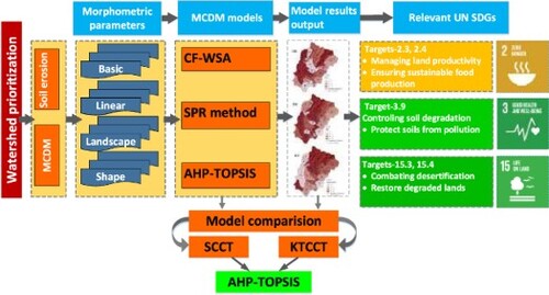
ABSTRACT
The Himalayan region is the most sensitive due to its fragility, especially in soil erosion; therefore, it is a growing concern for environmentalists and natural resource planners. The study river basin Mandakini is situated in the central part of the Garhwal Himalayan region (Uttarakhand, India), which is highly prone to soil erosion due to various hydro-geomorphological factors. The factors include precipitous slope, geology, rugged terrain, land use and drainage pattern. Therefore, to identify the erosion-prone areas of the study basin, employed watershed prioritization technique using geographical information system and remote sensing integrated with weighted sum analysis (WSA), sediment production rate (SPR) and Technique of Order Preference Similarity to the Ideal Solution with Analytical Hierarchical Process (AHP-TOPSIS) models. It is calculated by taking different parameters indicating linear, landscape, and shape parameters. All the sub-watersheds (SW) of the basin were prioritized in different categories for all models with model performance for the Mandakini river basin in the central Himalaya. The results are showing almost similar results except for high erosion-prone regions. The results of the SPR model indicate that vary large areas (43.47%) of the basin suffering from severe erosion limited in the north-central (WS11, WS12, WS21), eastern (WS2), and southern (WS22 and WS23) parts of the basin among 23 sub-watersheds. The result of model evaluation indicates AHP-TOPSIS is the efficient model in assessing soil erodibility. The study can help to undertake the precise decisions to propose an effective framework for soil erosion control measures and encourage soil conservation priorities of the region. The findings have implications for defining sustainable land resource management and conservation, which are critical to attaining the United Nations’ 2030 Agenda for Sustainable Development's societal goals.
GRAPHICAL ABSTRACT
Disclosure statement
No potential conflict of interest was reported by the author(s).