

ABSTRACT
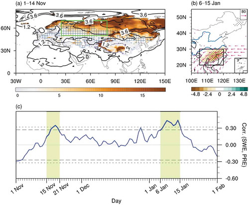
Evolution of the autumn snowpack has been considered as a potential source for the subseasonal predictability of winter surface air temperature, but its linkage to precipitation variability has been less well discussed. This study shows that the snow water equivalent (SWE) over the Urals region in early (1–14) November is positively associated with precipitation in southern China during 15–21 November and 6–15 January, based on the study period 1979/80–2016/17. In early November, a decreased Urals SWE warms the air locally via diabatic heating, indicative of significant land–atmosphere coupling over the Urals region. Meanwhile, a stationary Rossby wave train originates from the Urals and propagates along the polar-front jet stream. In mid (15–21) November, this Rossby wave train propagates downstream toward East Asia and, combined with the deepened East Asian trough, reduces the precipitation over southern China by lessening the water vapor transport. Thereafter, during 22 November to 5 January, there are barely any obvious circulation anomalies owing to the weak land–atmosphere coupling over the Urals. In early (6–15) January, the snowpack expands southward to the north of the Mediterranean Sea and cools the overlying atmosphere, suggestive of land–atmosphere coupling occurring over western Europe. A stationary Rossby wave train trapped in the subtropical westerly jet stream appears along with anomalous cyclonic circulation over Europe, and again with a deepened East Asian trough and less precipitation over southern China. The current findings have implications for winter precipitation prediction in southern China on the subseasonal timescale.
Graphical abstract
摘要
众多研究表明, 秋季积雪的时空演变是次季节尺度气温预测的重要依据, 然而其与降水变化的关系还未得到充分研究。本文分析发现, 在1979/80至2016/17时期, 11月前期 (1至14日) 乌拉尔山地区雪水当量与该年11月15至21日及次年1月6至15日中国南方降水有显著的正相关关系。乌拉尔山雪水当量在11月前期 (1至14日) 偏少时, 可以通过非绝热加热过程增暖其上空大气, 表现为显著的陆–气耦合。同时乌拉尔山地区出现准定常Rossby波列, 并沿极锋急流向东传播。在11月中期 (15至21日), 该波列向下游传播至东亚地区, 增强了东亚大槽强度, 使得中国南方水汽输送强度减弱, 降低了该地区的降水强度。在其后的11月22日至次年1月5日, 乌拉尔山地区陆–气耦合较弱, 其上空环流异常也较弱。在次年1月前期 (6至15日), 积雪向南扩展至地中海北侧地区, 并通过陆–气耦合作用冷却其上方大气。气旋性环流异常出现在欧洲上空, 同时伴随着沿副热带西风急流传播的准定常Rossby波列。该波列加深东亚大槽, 并减弱了中国南方地区的降水强度。本文研究结果可用于中国南方冬季次季节尺度降水的预测。
Disclosure statement
No potential conflict of interest was reported by the authors.