

ABSTRACT
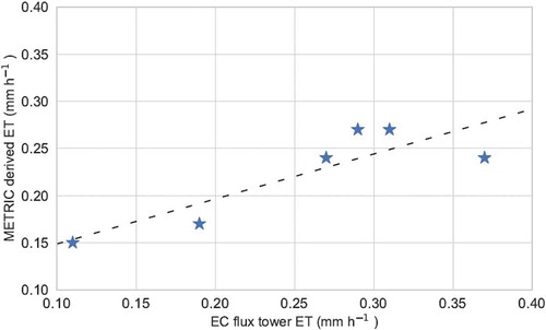
Climatic and atmospheric properties vary significantly within a small area for a topographically diverse region like Nepal. Remote sensing can be used for large-scale monitoring of atmospheric parameters in such diverse terrains. This work evaluates the Landsat-based METRIC (Mapping Evapotranspiration at High Resolution with Internalized Calibration) model for estimating Evapotranspiration (ET) in Nepal. The slope and aspect of terrain are accounted for in our implementation, making the model suitable for regions with topographical variations. The estimations obtained from the model were compared with ground-based measurements. The root-mean-square error for hourly ET (daily ET) was 0.06 mm h−1 (1.24 mm d−1), while the mean bias error was 0.03 mm h−1 (0.29 mm d−1). These results are comparable with results from other studies in the literature that have used the METRIC model for different regions of the world. Thus, this work validates the applicability of the METRIC model for ET estimation in a mountainous area like Nepal. Further, this implementation provides ET estimation at a very high resolution of 30 m compared to the best available resolution of 5 km in earlier works, without compromising on the accuracy. ET estimation with high resolution over a large region in Nepal has applications in agricultural planning and monitoring, among others.
Graphical abstract
摘要
鉴于尼泊尔地区地形复杂, 大气和气候特性的局地性变化很强, 我们尝试将遥感用于该地区复杂地形以检测大气参数。本研究评估了基于Landsat的METRIC模型在尼泊尔地区复杂下垫面估算蒸散量的适用性, 同时也考虑了地形的坡度和坡向对模拟的影响。结果表明, 每小时ET (每日ET) 的均方根误差为0.06mm h−1 (1.24mm d−1), 而平均偏差误差为0.03mm h−1 (0.29mm d−1) 。这一结果与前人评估METRIC模型所得到的结果类似, 因此验证了该模型在尼泊尔地区的适用性。我们的研究将ET估算的分辨率提升至30m的同时不会影响其精度。在尼泊尔的复杂地形下, 高分辨率的ET估算可用于农业规划和监测等。
Acknowledgments
The authors are grateful for the open-source data provided by the USGS.
Disclosure statement
The authors declare no conflict of interest.