
ABSTRACT
Placer gold on beaches on either side of a major active mountain belt has strongly contrasting compositions and morphologies. Pleistocene-Holocene beach gold placers have formed along the West Coast where silver (Ag)-bearing gold has been eroded from mountains via steep rivers and glaciers, followed by rapid burial in the abundant associated coastal sediments. Deformation along transport pathways has produced flattened gold flakes, but some primary crystalline shapes are preserved. Internal deformation of particles has caused recrystallisation to fine-grained (µm scale) grain structures including mylonitic banding. However, only minor localised (µm scale) Ag leaching has occurred on some particle margins. In contrast, Pleistocene beach placers formed on the southern side of the mountains contain flattened gold particles with a complex transport history involving long-distance (hundreds of km) fluvial transport since Cretaceous. Most primary Ag has been leached from this gold during transport-related recrystallisation to fine (5–20 µm) internal grains. Sand-blasting on the southern beaches with low sediment supply has resulted in further deformation and leaching of Ag to form toroidal shapes with Ag-free delicate extremities. Placer gold which has undergone rapid transport and deposition is useful as a prospecting tool for bedrock deposits in glaciated terranes around the world.
Introduction
Placer gold accumulations on beaches are widespread around the world, and many host mine sites, both historical and modern, although beach placers are typically smaller than fluvial placers (Boyle Citation1979; Eyles Citation1990; Tan et al. Citation1994; Garnett Citation2000; Garnett and Bassett Citation2005; Moufti Citation2014; Kungurova Citation2021). Despite these widespread occurrences and their local economic significance, there have been few detailed studies of the actual nature of beach gold particles in these placers (Eyles Citation1990; Fraser Citation2011; Kungurova Citation2021; Nikiforova Citation2021). Further, the limited previous work that has been done on these placers has focused on particle morphology, rather than particle chemistry (Fraser Citation2011; Kungurova Citation2021; Nikiforova Citation2021). The present study aims to fill this gap in knowledge by relating the observed chemical composition of gold, primarily the Ag contents, to the sedimentary transport and depositional environments and the accompanying morphological changes to gold particles.
Beach gold is principally derived from detrital gold carried to the coast by rivers, combined with longshore drift by ocean currents (Garnett Citation2000; Garnett and Bassett Citation2005; Craw et al. Citation2013; Moufti Citation2014; Hou et al. Citation2017; Ritchie et al. Citation2019). Consequently, the morphology and composition of beach gold are strongly affected by the onshore history of the fluvial gold, combined with subsequent coastal processes. In this study, we compare the compositions and morphologies of beach gold collected from two entirely different topographic and sedimentary regimes emanating from the tectonically active Southern Alps mountains of New Zealand (Norris et al. Citation1990; Koons Citation1995). One side of this orogen has steep short rivers that erode young orogenic gold deposits and feed that gold to beaches in a high-sedimentation setting (Koons Citation1995). In contrast, the other side of the orogen has lower relief and lower-gradient rivers (Koons Citation1995) and these are transporting older, multiply-recycled detrital gold to the beaches. The latter type of beach placer has been studied previously (Craw et al. Citation2013, Citation2015a; Palmer and Craw Citation2023), and we extend that work by making comparisons to previously undescribed beach gold from the more dynamic side of the orogen. The results of these observations are relevant for understanding gold transport history, not just for beach gold but for other exploration activities that involve detrital gold, especially for Pleistocene glacial-fluvial sediments that are common across the Northern Hemisphere (McClenaghan and Cabri Citation2011; Chapman and Mortensen Citation2016; McClenaghan and Paulen Citation2018; Chapman et al. Citation2021; Citation2022a, Citation2022b).
General setting
Tectonic geomorphology
The South Island of New Zealand lies astride the active Pacific-Australian tectonic plate boundary, with the Alpine Fault as the surface manifestation of that boundary (A; Norris et al. Citation1990). The Alpine Fault is currently an oblique convergent structure, with uplift rates up to 8 mm/year that has caused a rise of the 3-km high Southern Alps mountain backbone along the length of the island (A; Norris et al. Citation1990; Koons Citation1995). The mountains have been dissected by numerous deep valleys on both sides that channel rivers out to marginal outwash plains (A–D; Koons Citation1995).
Figure 1. Location hillshade DEM maps (geographx.co.nz) for aspects of this study, with transport directions for detrital gold. A, Topography of the Southern Alps in South Island of New Zealand. B, Oblique view from northwest of a portion of the Southern Alps goldfield, showing the topographic setting of beach placers. C, Map view of the northern portion of Southern Alps goldfield with the location of principal samples examined in this study in Late Pleistocene-Holocene beach placers near Lake Mahinapua. D, Map view of southern South Island showing topography on the southeast side of Southern Alps in the Otago and Southland goldfields and Cenozoic transport of gold to south coast beach placers.
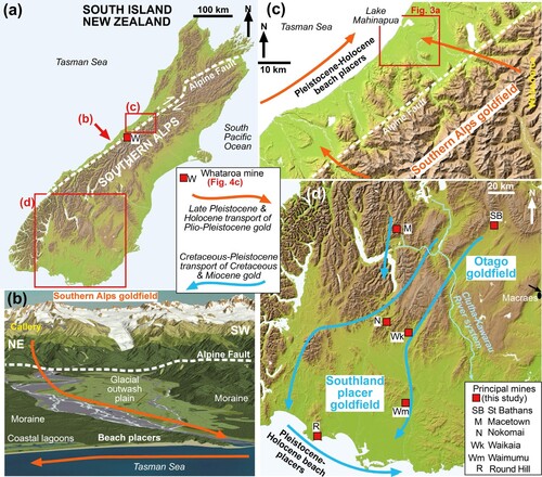
On the northwestern side of the mountains, high rates of orographic rainfall (up to 12 m/year; Griffiths and McSaveney Citation1983) have carved steep short valleys perpendicular to the mountains, and these discharge into the sea across a narrow coastal plain (A–C). Northeast-directed ocean currents sweep sediment along the coast (Ritchie et al. Citation2019), forming sandy beaches and bars with lagoons and swampy lands behind them (B). Uplift rates and erosion rates in the mountains are approximately equal, and there have been several kilometres of erosion in the hanging wall of the Alpine Fault since the Pliocene (Norris et al. Citation1990; Koons Citation1995). The valleys have been further modified by ice, as glaciers have periodically extended from the crest of the mountains to, and locally beyond, the present shoreline leaving extensive moraine deposits (B,C; Nathan et al. Citation2002; Cox and Barrell Citation2007).
In contrast, the southeastern side of the mountains is within a rain shadow caused by the prevailing westerly winds, and erosion rates are relatively low (Koons Citation1995). Consequently, the southeast side of the orogen is dominated by large areas of low-relief foothills and rounded mountain ranges that have topography defined by Cenozoic basement unconformity surfaces, locally with remnants of sediments as old as Cretaceous (A,D; Koons Citation1995; Craw et al. Citation2006; Craw et al. Citation2013; Upton and Craw Citation2016; Malloch et al. Citation2017). River valleys are oriented oblique to the orogen, with general drainage flowing towards the south or southwest (A,D; Koons Citation1995; Upton and Craw Citation2016). This drainage geometry has been disrupted by the progressive rise of the low mountain ranges, with numerous river capture events (Craw et al. Citation2013).
Goldfields and gold transport
Hydrothermal activity in the rising Southern Alps has formed scattered orogenic quartz vein-hosted gold deposits that have since been exposed to ongoing erosion (Craw et al. Citation2006; Upton and Craw Citation2016). This mineralisation was initiated in the Miocene at the southern end of the mountains and evolved progressively northeast in the Pliocene and Pleistocene (Craw et al. Citation1999; Citation2006). Erosion of these deposits has fed detrital gold into the river systems on both sides of the Southern Alps (Roy et al. Citation2018) but mostly on the northwestern side, to form what is called herein the Southern Alps goldfield (A–C). This goldfield, involving young orogenic and placer accumulations from them, is largely separate from what is commonly known as the Westland goldfield that includes Paleozoic orogenic deposits and fluvial placers derived from them (Williams Citation1974). Mining on the northwestern side focused on placer deposits in the rivers discharging from the mountains and on heavy mineral concentrates on the modern beaches (B,C) and on Pleistocene beaches farther onshore (Williams Citation1974). Historic mining of the orogenic veins was primarily confined to the Miocene deposits on the southeast side (e.g. Macetown; D; Craw et al. Citation2006), and these deposits fed some detrital gold into the southwestward drainage system (Upton and Craw Citation2016).
The Otago orogenic and placer goldfield on the southeastern side of the mountains (D) has been a major producer historically (∼8 Moz; 240 tonnes), and is still producing gold at the large (>12 Moz resource) Macraes orogenic deposit (D; Williams Citation1974; Craw and MacKenzie Citation2016). Most historic production was from fluvial placer deposits, including numerous paleoplacer deposits from Cretaceous to Pleistocene in age (Craw et al. Citation2013; Malloch et al. Citation2017; Palmer and Craw Citation2024). The older paleoplacer deposits occur as remnants in the tectonically active landscape, where uplift and erosion have repeatedly recycled gold into progressively younger fluvial sediments (Henley and Adams Citation1979; Craw et al. Citation2013; Chapman et al. Citation2022b; Palmer and Craw Citation2024). The Clutha-Kawarau river system (D) currently drains most of the Otago goldfield and has been a major producer of placer gold (Williams Citation1974; Youngson and Craw Citation1999; Craw et al. Citation2013).
Miocene rivers through the Otago goldfield carried detrital gold southwards and southwestwards into what is now the Southland placer goldfield (D), which has negligible orogenic deposits (Craw et al. Citation2015a, Citation2015b; Palmer and Craw Citation2024). Most drainage links between Otago and Southland were severed by tectonic uplift in the late Miocene and Pliocene, but recycling of detrital gold continued, with the formation of younger placers (Craw et al. Citation2013; Craw et al. Citation2015b; McLachlan et al. Citation2018; Chapman et al. Citation2022b; Palmer and Craw Citation2024). Some of this gold has been transported to the south coast, where it has been concentrated on Pleistocene and modern beaches sufficiently to be mined (D; Craw et al. Citation2013, Citation2015a; Craw and Kerr Citation2021; Palmer and Craw Citation2023).
Regional gold compositions
Orogenic gold compositions in both the Southern Alps and Otago goldfields are typical of orogenic gold elsewhere in the world (Morrison et al. Citation1991), with most consisting of >80 wt% Au (A; MacKenzie and Craw Citation2005). The Ag contents that are a focus of this study are typically <10 wt% in presently exposed sites in both goldfields (A). The Southern Alps orogenic gold has the most restricted compositional range, with Ag contents typically between 3 and 5 wt%, rarely extending to 6 wt% Ag, and no detectable Hg (A; MacKenzie and Craw Citation2005). Orogenic gold in Otago has a slightly wider compositional range for Ag, and highly variable Hg contents (A).
Figure 2. Typical gold compositions in Otago and Southland goldfields compared to Southern Alps. A, Plot of Ag versus Hg for orogenic gold in Otago (data replotted from MacKenzie and Craw Citation2005), with range for Southern Alps (red dashed box; Hg <1 wt%). B, SEM backscatter image of Southland Pleistocene fluvial gold (etched with aqua regia) overlain with Au map (left) and combined Au and Ag maps (right), showing red Ag-rich etching residues. Modified from Craw et al. (Citation2017). C, Silver content of bulk gold bars produced at Waikaia mine, Southland goldfield (D), in a Pleistocene paleochannel. Data replotted from Craw et al. (Citation2017). Ag content decreased over 2 km down the paleochannel. D, Range of Ag and Hg in placer gold from Nokomai mining area in Southland placer goldfield (D). Data summarised from Youngson et al. (Citation2002). E, Ag contents of beach gold particle cores on the south coast of Southland placer goldfield (Round Hill mining area; D). Data replotted from Mitchell (Citation1996).
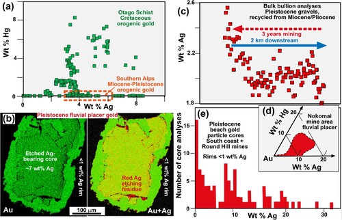
Placer gold compositions in the Southern Alps goldfield generally reflect the orogenic gold sources, with only minor deviations that are the subject of observations in the following sections. However, supergene processes and effects of sedimentary groundwater have apparently caused leaching of some Ag and Hg from gold in Otago and Southland goldfields (B,C; Stewart et al. Citation2017; Kerr et al. Citation2017; Malloch et al. Citation2017; Craw et al. Citation2017). This has resulted in most detrital gold having relict cores of Ag-bearing gold surrounded by rims with little or no Ag (B). At the mining scale, the bulk Ag content of Otago-sourced placer gold is near 2 wt% Ag but variable spatially depending on the position in the paleoriver system (C; Craw et al. Citation2017). In detail, there are also some detrital gold particles with cores containing Ag contents >10 wt%, and even rarer particles with Ag contents >30 wt% Ag (D,E; Mitchell Citation1996; Youngson et al. Citation2002; Malloch et al. Citation2017). These relatively Ag-rich particles presumably reflect minor basement sources that have not yet been identified (MacKenzie and Craw Citation2005).
Detailed analysis of Hg contents of inhomogeneous gold is difficult because of analytical overlaps between Au and Hg signals and is practically limited to Hg contents substantially >1 wt% (D; Youngson et al. Citation2002; MacKenzie and Craw Citation2005). Only one Southland placer mining area (Nokomai; D) has consistently high Hg contents in detrital gold (D; Youngson et al. Citation2002). The bulk placer gold analysed in C had Hg contents of ∼0.2 wt% but some additional Hg was driven off during the melting of the gold bars in the mine and was not specifically quantified (Craw et al. Citation2017). Rare beach gold particles on the south coast (Round Hill; D, E) have cores with Hg up to 6.7 wt% but no detectable Hg in associated rims (Mitchell Citation1996). However, no beach gold examined in this study had detectable Hg, and detailed Hg analyses were not pursued.
Methods
Sample selection
Beach gold is notorious for its fine particle size (commonly ∼100 µm) and difficulty of extraction (Kungurova Citation2021; Palmer and Craw Citation2023). Our general field work has involved the collection of numerous small samples with gold pans. However, such small samples tend to be poorly representative of the diversity of gold in beach and also in fluvial environments. Hence, in this study, we focus on more representative gold samples that have been extracted by mechanical concentration of larger volumes of host material in the mineral exploration and mining context. We use these bulk samples to characterise the chemical compositions and morphological variations of beach gold within the context of our more general observations of gold erosion and transport in the two contrasting tectonic-sedimentary settings of the Southern Alps goldfield and the Otago-Southland placer goldfields (A).
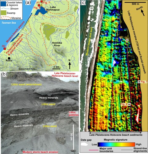
Beach gold from the Southern Alps goldfield was obtained from an exploration site for potential extraction of industrial garnets and associated placer gold from heavy mineral concentrates in Late Pleistocene-Holocene beach sands (C; A–E). The sample sites are ∼1 km inland from active beaches and associated lagoons, near Lake Mahinapua which is itself a large coastal lagoon (C; A). The sites are on a narrow flat coastal plain, close to eroded Pleistocene moraines derived from the nearby mountains (C; A,C). One sample for this study was taken from bulk material extracted from an excavation on an old coastal strand-line, and gold for that sample was mechanically concentrated. A nearby sample was extracted by manual panning from a heavy mineral concentrate in beach sediments at the foot of a Pleistocene moraine deposit (A,C).
Figure 3. Location and geological setting for Southern Alps Late Pleistocene-Holocene beach gold sample sites near Lake Mahinapua (C). A, Map of landscape features around the sample sites, with moraine distribution from Nathan et al. (Citation2002). B, Modern storm-eroded cliff section (site shown in a) through beach sediments including several heavy mineral layers. C, Total magnetic intensity (TMI) survey map (relative scale) of inland beach sands in the area for which samples were taken for this study. Heavy mineral concentrates with magnetite (and gold) are indicated in red-orange colours.
Samples from the Otago and Southland placer goldfields were obtained from fluvial placer mining areas and beach gold from a mine on the south coast (D). General descriptions of some of this gold have been published previously (Craw et al. Citation2015a, Citation2015b; Kerr et al. Citation2017; Stewart et al. Citation2017; McLachlan et al. Citation2018; Craw and Kerr Citation2021; Palmer and Craw Citation2023), and we build on those previous observations. In addition, we have obtained gold from exploration drillholes in the St Bathans fluvial mining area (D; Henderson et al. Citation2016; Palmer and Craw Citation2024). These samples of fluvial gold are from the headwaters of the main Miocene paleochannel that contributed gold to the Southland goldfield (D; Craw et al. Citation2013; Craw et al. Citation2015b; Palmer and Craw Citation2024). Hence, these samples provide a view of the gold that was a precursor to the more chemically and morphologically evolved gold that occurs in the Southland goldfield and ultimately ended up in the beach placers of the south coast. Consequently, we focus part of this study on that precursor gold in comparison to the downstream beach gold.
Aqua regia etching
Preparation of polished sections of gold for detailed examination inevitably causes smearing of the soft gold surface and disruption of that surface texture (Kerr et al. Citation2017; Stewart et al. Citation2017). Hence, it is necessary to remove this surficial smear artefact, commonly called the Beilby layer (e.g. Stewart et al. Citation2017). One method for such removal is etching with aqua regia, and that was employed for all polished samples in this study. An advantage of this method is that aqua regia etches Ag-bearing gold more rapidly than pure gold, resulting in clear visual distinctions between these two gold compositions within particles (e.g. B; Craw et al. Citation2017). A disadvantage is that the process leaves an Ag-rich residue locally on the etched surface (B). Etching also exaggerates polishing scratches on sample surfaces.
The etching process proceeds rapidly (seconds) with fresh aqua regia and can be difficult to control and etch to similar depths in different polished sections. In order to better control this etching process and make direct visual comparisons between gold from Lake Mahinapua (Southern Alps goldfield) and St Bathans gold (Otago-Southland goldfields), we prepared a single resin block with two samples from each goldfield embedded and polished. This block was etched using old (>1 year) aqua regia for ∼5 min in total, with checking each minute, until internal textures were visible in St Bathans gold particles. The principal internal textures exposed in St Bathans gold were those associated with Ag-bearing cores and low-Ag rims. Importantly, similar textures were not observed on the Lake Mahinapua gold, which remained uniform in appearance.
Electron microscopy
Particles were mounted on aluminium stubs using double-sided carbon tape for observations of external morphology. The samples were not carbon-coated, so any associated silicates displayed bright charging phenomena. Observations were made on a Zeiss Sigma VP (variable pressure) scanning electron microscope (SEM) at the Otago Micro and Nanoscale Imaging (OMNI) (University of Otago, New Zealand). Backscatter-electron images (BEI) were obtained at 15 kV. Samples embedded in 25-mm epoxy resin discs were ground to expose sections through the particles before polishing and aqua regia etching (as above), and carbon-coated before examination with the SEM. Analyses of Ag contents of gold were obtained via energy dispersion (EDX) attachment to the same SEM. A beam size of 3 µm was used at 15 kV to make spot analyses on polished and etched specimens, for which the detection limit was ∼0.5 wt% Ag.
Etched surfaces are rough, especially where scratches are enhanced, and where there are Ag contrasts that cause differential etching depths and enhance surface topography (B). Since the analytical surfaces are not flat, spot analyses are merely semiquantitative, and we use the results in a relative sense only. The inevitable presence of Ag-bearing etching residues (above; B) further limited analytical precision. In the text, we quote most low-Ag analyses as ‘<1 wt% Ag’. For the purposes of most aspects of this study, the distinction between ‘Ag-bearing’ and ‘<1 wt% Ag’ gold was the principal analytical target. This general distinction was further documented semiquantitatively with Au and Ag element maps produced by automatic scanning of rectangular areas of the specimen.
Internal grain structures of etched gold particles were recorded via electron backscatter diffraction (EBSD) maps using the same Zeiss VP-FEG-SEM equipped with an Oxford Instruments Nordlys F EBSD camera. Details of instrumental settings and subsequent data processing are provided by Palmer and Craw (Citation2023) and not repeated herein. Gold particles were mapped by scanning the electron beam over rectangular map areas and imaged EBSD patterns were automatically indexed by Oxford Instruments Aztec version 4.1 SP1 software. The EBSD data were exported to HKL Channel 5 software for further processing. Inverse pole figure (IPF-Y) maps were initially created with the Aztec software, and crystallographic misorientation maps were also created to show local misorientations below the subgrain angle of 2°. Grain boundaries were added where misorientation angles were >10° and sub-grain boundaries were added where misorientation angles were >2°.
Results
Source and transport of Southern Alps beach gold
Plio-Pleistocene gold-bearing orogenic vein systems occur principally in the high mountains, 1-3 km above sea level where steep rock faces are eroded rapidly by glaciers and streams (B, A). The gold occurs in quartz veins that cut across the fabric of the metamorphic schist basement, this vein material is readily liberated into the steep and active glacio-fluvial system (A–C). The coarsest gold has accumulated during the Holocene in river gravels at a sharp break in slope near the Alpine Fault (B; C). The gold in C was extracted in a small mine ∼1 km upstream from the Alpine Fault (B) and includes well-flattened flakes and rough irregular particles, some of the latter retaining remnants of hydrothermal quartz. During Pleistocene glaciations, gold was also carried with the entrained till and deposited in moraines on the coastal plains and locally beyond the present shoreline (B; A). Subsequent erosion of these moraines has released gold into the nearshore and littoral sedimentary systems.
Figure 4. Geological features of the active components of Southern Alps goldfield. A, An example of source area (Callery valley; B) for erosion of Plio-Pleistocene orogenic gold from uplifted schist basement. B, Example of eroded orogenic gold in a quartz vein cobble. C, Coarse fluvial gold from a small mine located at the break in slope immediately upstream of Alpine Fault (Whataroa River; A). Some particles retain remnants of host vein quartz (Qtz). D, Active beach placer concentrations of gold-bearing heavy mineral sands (dark streaks). E, Section through modern beach sand, showing several subsurface heavy mineral layers.
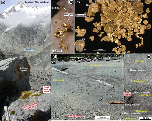
The coastline receives abundant sand in this high sedimentation tectonic setting, and the sand is highly mobile laterally via longshore drift (B; D,E). Modern beach gold deposits occur in heavy mineral layers formed by surf-driven winnowing of lithic beach sands derived from the mountains via the river and moraines (B; D,E). The heavy mineral sand layers are dominated by garnet and ilmenite, with subordinate magnetite and zircon, and gold has been concentrated with these minerals. Modern beaches have widespread irregular surficial coatings of these concentrates (D) and can have several subsurface layers as well (E). However, these sedimentary features are regularly eroded and re-formed by storm events as the entrained gold migrates northeastwards (B). More onshore gold is added to the beaches by the various rivers and from surf erosion of coastal moraines.
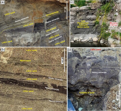
In addition, one of the most significant contributors of gold to modern beaches is the erosion of older (Late Pleistocene-Holocene) beach sediments, with their heavy mineral concentrates (B,C). These deposits form narrow (< 2 km) coastal plains along the coast and their preservation has been facilitated by the abundance of sand supply, sea level changes, and tectonic uplift (up to 2 mm/year in late Holocene; Suggate Citation1968). The samples for the present study were obtained where beach sands progressively accumulated in a coastal embayment, causing shoreline progradation (C).
Within this sampled coastal plain, heavy mineral concentrates were preserved in distinct narrow (∼20 m) linear strand-lines that are traceable geophysically (TMI) for several km (C). Internally-coherent units of older strand-lines (∼200 m scale) have trends that are truncated at a low angle (<10°) by younger units (C). Numerous buried heavy mineral layers of varying thickness (0.01-0.5 m) occur at 1-3 m depth along these strand-lines, interlayered with lithic sands (B; A–D). Minor internal unconformities truncate heavy mineral layers locally (A). On the onshore edge of this sandy coastal plain, beach sediments with heavy mineral concentrates abut Pleistocene moraine debris (C,D).
Figure 5. Late Pleistocene-Holocene beach sediments were excavated ∼1 km inland from the modern shoreline for extraction of gold samples. A, Excavation wall in beach sands near sample site, showing truncated heavy mineral layers. B, Close view of an excavation wall in beach sands (as in a) showing heavy mineral layers. C, An excavation site in beach sands at foot of moraine deposit (A,C). D, Close view of basal heavy mineral layers in c, from which gold in was extracted.
Morphology of Southern Alps beach gold
The Pleistocene beach gold has a wide range of external shapes, from rough and irregular particles, including rough rods, to well-flattened smooth flakes (A–N; A–J). This range of shapes is similar to that seen in onshore fluvial gold, but the beach gold is generally finer (<0.4 mm; A; A) rather than ∼1 mm in the fluvial setting (C). The two samples focused on in this study are broadly similar in the range of particle shapes, although the northern sample has a higher proportion of well-flattened flakes (A, A).
Figure 6. SEM backscatter images of beach gold extracted from exploration bulk sample near Lake Mahinapua (C; A,C; A,B). A, General view of gold shapes. B–E, Particles with remnants of orogenic crystalline gold forms. F–I, Irregular particles with variably deformed rough surfaces. J–M, Flakes with smoothed and deformed surfaces. The particle in l has embedded fine silicate clasts. N, Close view of a cavity in m, with a cluster of vermiform gold.
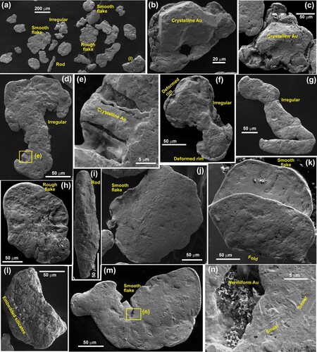
Figure 7. SEM backscatter images of beach gold panned from a heavy mineral concentrate near moraines at Lake Mahinapua (C; A,C; C,D). A, General view of gold shapes. B, Rounded particle with remnants of crystalline forms. C,D, Smoothed flakes. E–H,. Close views of flake surfaces with vermiform gold in depressions. I, J, Smooth flake with embedded silicate clasts (S), partially covered with smeared surface gold.
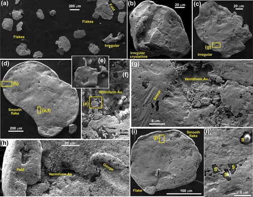
Some of the irregular beach particles in both samples have remnants of primary crystalline gold morphology, especially where preserved in embayments within the particles (B–E; B). However, there is abundant evidence of marginal ductile deformation of rough particles that has overprinted the primary structures (B–F; B). At the other end of this morphological spectrum, flakes vary from rough and thick to smooth and thin (H, J–M; D,I). Flake have been deformed to produce thickened rims, partially folded over (J,M; D,H,I) and some of the thinner flakes are fully folded (K; A). Flake surfaces show abundant evidence of transport-related deformation at the 1–10 µm scale, such as ductile smears and gouges (J,N; G,H). This deformation has caused the common inclusion of fine silicate particles, some of which are almost fully embedded beneath deformed surficial gold (L; J). Despite these near-pervasive deformation features, small embayments in particle surfaces commonly contain delicate vermiform gold at the micron scale (H; D–H).
Internal structure and composition of Southern Alps beach gold
The range of internal structures of the beach gold is quantified herein with the comparison of particles from the ends of the spectrum of morphological evolution described above: a rough irregular particle with a deformed extremity (A–G) and a smooth folded thin flake (A–F). The EBSD data in and show the internal structures of these particles at a range of scales. In addition, both particles have localised surficial vermiform gold coatings in embayments on their rims, and parts of these are visible in the etched sections, allowing extraction of some chemical observations (A,B; E,F).
Figure 8. SEM views of the internal structure of an irregular Southern Alps beach gold particle. A, Backscatter electron image of surface etched with aqua regia but showing no contrasts in internal structure. B, Part of an image in B, overlain with Au and Ag element maps to show dominant Ag-bearing gold (green) and Ag-depleted gold on the upper margin (increasing red colouring). A portion of a coating of Ag-free vermicular gold occurs on the bottom side (red). C, EBSD IP view of the least-deformed, coarse-grained portion of the particle. D, EBSD crystallographic misorientation map of part of a large grain on particle margin in C. E, EBSD crystallographic misorientation map of moderately deformed part of a particle. F, EBSD IP view of the most-deformed and extended part of the particle. G, EBSD crystallographic misorientation map of part of the deformed extension in f.
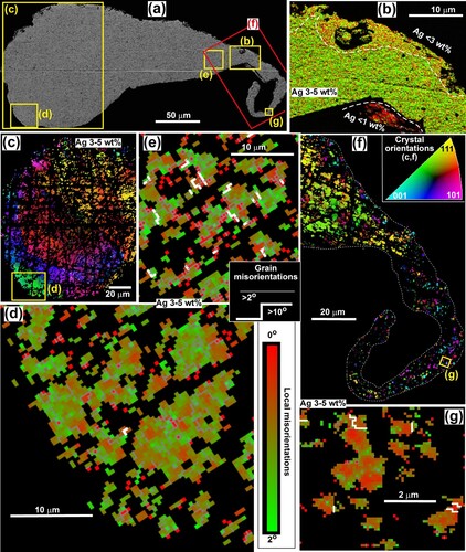
Figure 9. SEM views of the internal structure of a complexly folded Southern Alps beach gold flake. Legends are the same as in . A, Backscatter electron image of surface etched with aqua regia but showing no contrasts in internal structure. B, EBSD IP view across the particle. C, Close view of ribbon textured gold, as indicated in B. D, EBSD crystallographic misorientation map of part of the ribbon textured gold, as indicated in b. E,F, Parts of an image in A, overlain with Au and Ag element maps to show dominant Ag-bearing gold (green) and Ag-depleted marginal gold (increasing red colouring). A portion of a coating of Ag-free vermicular gold occurs on the top side of e (red).
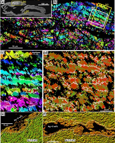
The least-deformed interior part of the rough particle consists of large (>100 µm scale) crystalline grains (A,C). There has been some internal deformation of these grains, resulting in gradational changes in crystal orientations across the grains. The intensity of this internal deformation increases towards the margin of the particle, as shown by the detailed structure of a single large marginal grain (C,D). The crystal structure of this grain has been deformed to form numerous subgrains (>2° misorientations) at the 5 µm scale (D). Further, these subgrains all have variable internal misorientations on the micron scale (D). Towards the more deformed end of this particle, the original coarse grains are no longer preserved, and these have been replaced by fine (10 µm scale) grains (E,F). These finer grains also have abundant internal grain misorientations at the micron scale (E). The highly deformed and attenuated extremity of this particle is poorly resolved with EBSD (F) but apparently consists of micron-scale or even finer grains with internal misorientations (F,G).
The thin flake (A) has no remnants of coarse primary gold and now consists entirely of fine (10 µm scale or less) grains with variable internal deformation (B–D). Many of the grains are approximately equant in shape, but parts of the particle are dominated by highly elongated grains that are oriented oblique (∼20°) to the flake margin (B). These latter grains are ribbon-like (B-D), similar to some mylonitic textures in silicates, and may have similar origins via intense ductile deformation. In detail, these ribbon grains are made up of abundant subgrains (>2° misorientations; C). The ribbon grains are accompanied by numerous smaller and more equant grains at micron scale or even finer, with abundant internal misorientations (C,D).
Chemically, the beach gold is remarkably uniform in composition, with Ag contents of 3-5 wt% in all particles. Compositions are similar in cores and on most rims. However, the vermiform gold on exterior surfaces is relatively depleted in Ag. EDX analyses conducted directly on this vermiform gold exposed on exterior surfaces indicate <1 wt% Ag, although interference from underlying Ag-bearing gold confounds such analyses. In the polished sections through particle margins, Ag variations are more complex (B; E,F). The well-defined external gold coating has Ag content clearly <1 wt% (B, lower centre). In contrast, parts of the rim zone of the gold particle have Ag contents that are lower than the core, but higher than in the exterior coating (B; E). A similar Ag depletion zone occurs on both sides of an internal fold of the deformed flake (A,F). These zones of Ag depletion, and the low-Ag exterior coatings, occur only at the micron scale (B; E,F).
Source, recycling and onshore transport of Southland beach gold
Gold in Southland placers has undergone long-distance (>100 km) fluvial transport from the Otago goldfield (D), and this transport has caused progressive modification of the gold (A–I). Part of this transportation of gold from Otago primary sources involved recycling through various intermediate paleoplacer deposits, and some of the gold that ultimately ended up on Southland beaches may have started detrital passage in the Cretaceous (D; A,B). Even the youngest (Miocene) primary sources in the Otago goldfield (e.g. Macetown; D) have contributed detrital gold to Southland over >20 million years. This temporally and spatially long and complex sedimentary history is in strong contrast to the short transport distances and time scales (described above) that characterise the Southern Alps gold placers on the northwest side of the mountains (A,B; A–E).
Figure 10. Evolution of fluvial placer gold particles in Otago and Southland goldfields. A, SEM backscatter image of an etched polished section through the edge of a particle of Otago Cretaceous fluvial gold, showing Ag variations. B, SEM EDS element map for Ag on a flat portion of the exterior surface of a Cretaceous particle. C, SEM backscatter image of the surface of Otago Eocene fluvial gold particle, with vermiform authigenic gold (left) and smeared gold (right). D, EBSD Euler colour map (modified from Kerr et al. Citation2017) of fine grains of the smeared gold surface, as in d. E, EBSD Euler colour map of a particle of Otago Miocene fluvial gold, with a yellow dashed boundary between Ag-bearing coarse-grained core and low-Ag fine-grained rim. F, Incident light view of etched gold from Pleistocene deposit (Waikaia mine; D) in Southland goldfield. Large particle has a deeply leached Ag-bearing core and prominent rim of low-Ag gold. G, EBSD IP view of grain structure in small particle in F, showing contrasts between core and rim. H, Incident light view of thin Ag-poor Southland flake with a small remnant of Ag-bearing core. I, Backscatter electron image of thin folded Southland flake with very small remnant Ag-bearing core.
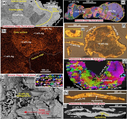
The extended transport and recycling history resulted in the progressive modification of initially rough and irregular detrital gold to form populations dominated by thin flakes (A–I). Some irregular and thicker particles persisted through these complex processes, but their external surfaces became progressively smoothed and rounded (E–G). Extensive surficial smearing contributed to these shape changes (C). Almost all the detrital gold developed rims of relatively fine grains (typically 5–20 µm) around cores of coarser grains (A,E,G). Smeared exterior surfaces have even finer grains (micron scale; D). Despite this extensive surface deformation, many particles from paleoplacers of all ages have micron-scale vermiform gold coatings, especially in embayments (C). Some patches of vermiform gold have been incipiently flattened by deformation during recycling stages, but are still recognisable as coatings rather than components of the fine-grained rims.
The development of fine-grained particle rims was accompanied by the leaching of Ag from the gold particles to form relatively low-Ag rims. Cretaceous particles commonly have a transitional zone of depleted Ag towards their outer edges, and some exterior surfaces still retain up to 3 wt% Ag (A,B). However, gold particles from younger paleoplacers all have fine-grained rims with <1 wt% Ag (C–I). The rims are highly irregular in thickness around the particles, and some rimless coarse grains can persist to the particle edges (E–G). The vermiform gold coatings all have <1 wt% Ag (C).
Silver leaching occurred initially along coarse grain boundaries, where new fine grains were forming from deformed coarse grains (A–G). Irregular micron-scale Ag-free grains developed from deformation-induced subgrains along and near these grain boundaries (A–C). With further deformation and Ag leaching, patches of low-Ag gold developed with slightly coarser grain size (5–20 µm) around the rims and extending into the particles (E–G; D–G). With the progressive development of thin flakes, the proportion of Ag-depleted rim gold increased, and the size of the core decreased (H,I) and many Southland flakes have no remaining Ag-bearing cores. These changes are responsible for the downstream decrease in Ag content of mine-derived bulk gold (C).
Figure 11. Microscopic views of the internal structure of Otago and Southland fluvial gold (etched with aqua regia), showing details of Ag leaching to leave Au-rich portions. A, Backscatter electron image of core grains of a particle, overlain with Au and Ag element maps to highlight Ag-poor (red; high relief) grains that have formed by Ag-leaching along coarse grain boundaries. B, Backscatter electron image of a particle in a, showing larger scale zones of Ag leaching (paler, Ag-poor zones) along grain boundaries. C, EBSD IP view across a gold particle from Southland goldfield showing contrasts in grain sizes and Ag contents. D, Incident light view of a particle in C. E,F, Close views of areas of Ag leaching and grain size reduction, as indicated in C. G, Incident light view of a Southland particle with a prominent Ag-poor rim (darker yellow) and extensive irregular and scattered internal Ag-leached patches and fine grains.
Morphology and composition of Southland beach gold
Detrital gold has reached the south coast via the rivers of the Southland placer goldfield and readily accumulates on beaches in heavy mineral concentrates (A,B). These gold-bearing heavy mineral concentrates are dominated by garnet and ilmenite, with subordinate magnetite and zircon, similar to those on the northwestern beaches (D,E). These processes have been occurring through the Pleistocene, and Pleistocene beaches with heavy mineral concentrates occur above the present sea level, similar to those on the northwestern coast. Localised recycling of beach sediments has occurred, and the Round Hill mines have been developed in marginal marine fluvial channels where the gold and other heavy minerals were further concentrated (Craw and Kerr Citation2021; Palmer and Craw Citation2023).
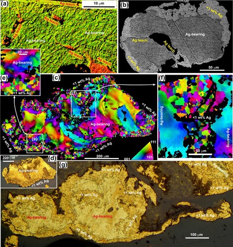
Figure 12. Beach gold on the south coast of the Southland goldfield, in the Round Hill mining area (D). A,B, Gold-bearing heavy mineral concentrates (dark) on an active beach. C,D, SEM backscatter images of detrital gold on an active beach at the mouth of a gold-bearing river. E, Recycled toroidal beach gold in a Pleistocene marginal marine fluvial channel. F, Polished section view of toroids (yellow) with relict Ag-rich cores arrowed. White flakes are platinum. G, Backscatter electron image (modified from Palmer and Craw Citation2023) of a spheroidal toroid with relict Ag-bearing core (dark green, with EDX analytical spots). The image is overlain with Au and Ag element maps to highlight Ag-poor (lighter green) rim and attenuated rim protrusions. H, EBSD crystallographic misorientation map of a toroid, showing variations in grain size (white grain boundaries) and amounts of internal crystallographic misorientations. I, Enlarged view of toroidal rim protrusion in h, showing fine grain size and misorientations.
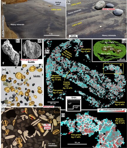
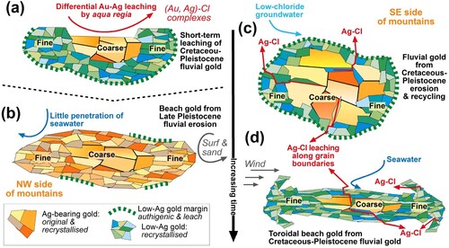
When detrital gold first arrived on the south coast it had the fluvial textures and morphology (C,D) inherited from its complex pathway from Otago goldfield (above). However, the relatively low sediment supply to beaches compared to the northwestern beaches, combined with regular surf activity, ensures that the south coast heavy mineral concentrates remain exposed at the beach surface for long intertidal periods (A,B). Strong winds acting on these concentrates caused substantial modification of the particles by sand-blasting, to yield toroidal shapes that predominate in the beach placers (E–I; Craw and Kerr Citation2021; Palmer and Craw Citation2023).
Edges of flakes were deformed during the wind-driven processes to cause the development of attenuated protrusions extending around both sides of the particles, with a thin relict central zone (E,F,H). Some of the attenuated edges merge from both ends to form spheroids with internal voids (F,G). Relict cores with relatively coarse grains survive in some of these toroidal particles (H). However, these core grains are internally deformed with abundant misorientations and some subgrain formation (H). Most of the toroids consist of medium-fine grains (5–20 µm), with the attenuated marginal protrusions dominated by even finer, micron-scale, grains (H,I). All these grains have some local misorientations internally (H,I).
Beach gold relict coarse-grained cores have a wide range of Ag contents, from <1 wt to >30 wt% (E; F–H). However, the marginal grains that dominate the toroid structures have <1 wt% Ag throughout (F-I). Many of the toroids have no remaining Ag-bearing core grains (F) and consequently are essentially pure Au. It is not clear how much Ag leaching has occurred in the beach environment rather than in the complex previous fluvial history (e.g. , ). However, textural observations suggest that deformation-induced grain size reduction and recrystallisation have occurred during the sand-blasting transformations (H,I), and any Ag-bearing grains affected by these processes are likely to have lost Ag, as occurred in the fluvial environment (e.g. A–G).
Discussion
Differential Ag and Au mobilisation in detrital gold
There is abundant evidence for Ag depletion in gold from the Otago and Southland goldfields, and this typically accompanied by grain size reduction (; Stewart et al. Citation2017; Kerr et al. Citation2017; Malloch et al. Citation2017; Craw et al. Citation2017; Palmer and Craw Citation2024). Silver depletion of placer gold, especially particle rims, has been observed around the world (Desborough Citation1970; Groen et al. Citation1990; Knight et al. Citation1999; Chapman et al. Citation2000; Citation2011; Chapman and Mortensen Citation2016). The Ag depletion is enhanced by distance of travel and associated hammering of the gold particles into thin flakes (C; E–I; Groen et al. Citation1990; Knight et al. Citation1999; Craw et al. Citation2017).
Silver is soluble in surficial waters as chloride complexes under moderately oxidising conditions (Mann Citation1984; Webster and Mann Citation1984), as depicted in A. Groundwater in the Otago goldfield has locally elevated dissolved chloride from a combination of marine aerosols in rain and high evaporation rates in the rain shadow of the mountains (Craw and Kerr Citation2017). Similarly, damp coastal areas receive abundant marine aerosols that enhance the chloride content of groundwaters (Craw and Kerr Citation2017; Citation2021). Hence, Otago and Southland groundwaters have presumably contained at least some dissolved chloride throughout the Cretaceous-Cenozoic history of the goldfield. The model in A indicates that Ag can be readily chemically mobilised by chloride-rich groundwater with a high dissolved Ag of 1 mg/L. The model also predicts that precipitation of authigenic native Ag can occur if the chloride concentration decreases at neutral-alkaline pH, as has been observed at the Round Hill gold mine near the south coast (B). Long-term groundwater leaching with lower chloride concentrations could also mobilise Ag at lower concentrations than 1 mg/L, and this is a more plausible scenario for Ag leaching from detrital gold, with slow penetration of groundwater along grain boundaries (e.g. A,B; Stewart et al. Citation2017). This leaching process is probably enhanced by deformation-induced grain size reduction and gold recrystallisation (Kerr et al. Citation2017; Stewart et al. Citation2017). Likewise, the removal of Ag from the Au-Ag alloy can enhance porosity and permit further water incursion (Erlebacher et al. Citation2001).
Figure 13. Geochemical models for solubility of Ag and Au. A, Geochemical model (from Geochemists Workbench®) of Ag solubility in chloride solutions, with typical environmental water compositions (green boxes). The main diagram is for moderately oxidised waters; the effects of lower redox conditions are shown at the lower left. B, Backscatter electron image of authigenic silver (Ag) on clay at Round Hill placer mine, south coast (D). C, Solubility of gold in near-surface environments (modified from Craw and Lilly Citation2016).
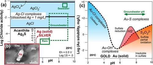
It is notable that this Ag mobility is independent of water pH (A), whereas chemical mobilisation of gold via chloride complexes occurs at low pH (C; Mann Citation1984; Webster and Mann Citation1984), outside typical surficial environmental conditions in all the New Zealand placer goldfields (Craw and Kerr Citation2017). Our observations with short-term high-chloride leaching of gold with aqua regia suggests that Ag-bearing gold is more susceptible to such leaching than Ag-poor gold despite the acidic conditions (B; A,B; A). The presence of dissolved sulphur under low redox acid conditions with low dissolved chloride can cause formation of solid acanthite, but as chloride increases any acanthite will dissolve as well, as implied by our modelling (A).
Figure 14. A, Differential chloride leaching of Au and Ag by aqua regia (e.g. B). B, Young Southern Alps beach gold has resisted Ag leaching and is frequently buried out of the wind by surf and sand. C, Otago-Southland fluvial gold has progressive Ag leaching along grain boundaries (e.g. ). D, Southland beach toroid with enhanced Ag leaching during wind-driven deformation.
Dissolution of Au in surficial environments is more constrained by local chemical conditions than Ag dissolution (A,C). In the alkaline pH environments typical of the New Zealand goldfields in this study, Au mobilisation occurs primarily as sulphur complexes under relatively low redox conditions (C; Craw and Kerr Citation2017). The most favourable chemical environments for Au mobility are within the oxidising primary deposits, with decomposing sulphide minerals (A; Webster Citation1986; Craw and Lilly Citation2016; Craw and Kerr Citation2017). However, the widespread occurrences of micron-scale vermiform and locally crystalline gold coatings on placer gold attest to minor Au mobility in groundwater in placer systems (N; E–H; C; A–C; Kerr et al. Citation2017). This localised Au mobility may be facilitated by bacterial activities at the micron scale (Reith et al. Citation2007; Kerr and Craw Citation2017).
Contrasts in beach gold across the mountains
Toroids on the Southland beaches are formed by deformation driven by wind-driven sand-blasting deformation of gold particles (Craw and Kerr Citation2021; Nikiforova Citation2021; Palmer and Craw Citation2023). The requisite surface exposures of gold within the heavy mineral concentrates on intertidal beaches (A,B) is facilitated by relatively low sediment supply to the coast compared to the high erosion environment west of the mountains (A–E). Equivalent toroidal gold shapes are absent from the Southern Alps beaches, and the beach gold instead largely retains morphological features imposed in the short fluvial transport distances (, ). Even some evidence of primary crystalline gold morphology persists on the Southern Alps beaches (B–E; B), in total contrast to the flattened flakes that dominate the precursor particles for toroid formation on Southland beaches (F–I; D; Craw et al. Citation2013). Wind exposure and toroid formation may be prevented on Southern Alps beaches by the high sediment supply and frequent storm re-burial of the heavy mineral concentrates (B; D,E; B).
Seawater, with its high chloride content, pervades a beach environment and can interact with beach gold particles that are undergoing physical deformation, and these processes apparently contribute to additional leaching of Ag from toroidal gold on the south coast (H,I). However, this effect is largely absent, or locally minor at the micron scale, from Southern Alps beach gold (B; E,F; B). The short time scales (<1 million years) of the passage of Southern Alps gold from source to beach placer preservation () are apparently insufficient for Ag leaching that occurs over millions of years in Otago and Southland (B–D).
The relatively unmodified nature of Southern Alps beach gold is likely to be observed elsewhere in the world where young orogenic gold deposits are eroded from active mountain belts, such as the beach gold of eastern Taiwan (Tan et al. Citation1994) and the southwestern Alaskan coast (Eyles Citation1990; Upton and Craw Citation2016). The high sediment supplies and rough ocean-facing environments of such settings, like the Southern Alps beaches, may preclude the formation of toroidal beach gold. In contrast, beach gold that has had a long and complex previous history, like that of Otago and Southland, is predicted to show abundant Ag depletion associated with morphological evolution, for example in areas such as northwestern Alaska (Garnett Citation2000) and northern Siberia (Nikiforova et al. Citation2011). These more passive coastlines, and their precursors at times of different sea level, may have been more conducive to the formation of toroidal gold, such as has been observed on the Siberian platform (Nikiforova et al. Citation2011; Nikoforova Citation2021). However, these predictions have yet to be tested with direct observations of the structure and composition of gold from such contrasting areas.
Significance for gold exploration around the world
Detrital gold is commonly used in exploration programmes as an indicator for upstream deposits (Townley et al. Citation2003; McClenaghan and Cabri Citation2011; McClenaghan and Paulen Citation2018; Chapman et al. Citation2021, Citation2022a). Further, the morphology of detrital gold particles, including progressive development of flake flatness, has been used as an indicator of the distance of travel of that gold, at least semiquantitatively, to indicate potential source areas (Knight et al. Citation1999; Youngson and Craw Citation1999; Townley et al. Citation2003). Gold compositions, low-Ag rim development extent, and mineral inclusions in detrital gold particles can be used as an indicator of the distance of travel and potential type of upstream basement sources (e.g. Knight et al. Citation1999; Youngson and Craw Citation1999; Townley et al. Citation2003; McClenaghan and Cabri Citation2011; McClenaghan and Paulen Citation2018; Chapman et al. Citation2021, Citation2022a,b). However, as noted for Otago and Southland goldfields in this study, detrital gold that has undergone numerous stages of recycling over millions of years can be transformed morphologically to yield thin flakes with little or no original gold composition such as the Ag component (). At the same time, gold has been redistributed fluvially over hundreds of kilometres, including in river systems that no longer exist (D; Youngson and Craw Citation1999; Craw et al. Citation2013; Palmer and Craw Citation2024). Similar processes are likely to have occurred in other goldfields around the world in which there is a substantial time gap between hydrothermal gold emplacement and later deposition of detrital gold (Craw Citation2010). Consequently, links to primary sources commonly become obscured by these transport-related and time-related processes.
Conversely, our observations of Southern Alps beach gold in this study show that detrital gold particles can be transported from primary sources to buried deposition sites on much shorter time scales (<1 million years) with almost no change in original chemical composition despite the substantial morphological changes (). This short sedimentary life was facilitated by the steep topography and rapid erosion, especially glaciation (). These observations are relevant to exploration activities in other glaciated terranes, especially large parts of the Northern Hemisphere that were extensively glaciated during the Pleistocene (McClenaghan and Cabri Citation2011; Chapman and Mortensen Citation2016; McClenaghan and Paulen Citation2018; Chapman et al. Citation2021; Citation2022a, Citation2022b).
From our observations across an active mountain belt, it is clear that the extent of development of Ag-depleted rims on gold particles, with associated recrystallisation to finergrained gold, gives an indication of the relative complexity of the transport history of that gold. In particular, it is the gold particles with the smallest, or no, Ag-depleted rims that are the most useful as indicators of erosion and transport directly from basement sources that may still exist nearby. However, it is difficult in this setting to use particle morphology, such as the extent of flattening, as an indicator of distance of travel, because of differential tumbling and liberation of particles in the short but dynamic fluvial systems.
Conclusions
Silver can be leached from detrital gold particles as soluble Ag-Cl complexes by chloride-bearing groundwater in fluvial environments and by seawater on beaches. Leaching is focused by water penetration along crystallographic grain boundaries, especially on the particle rims but also extending into the gold particles. This is further facilitated by crystallographic grain size reduction that is induced by transport-related deformation and recrystallisation of the gold as shapes evolve from irregular particles to flattened flakes. In southern New Zealand, these processes have become most advanced during long-distance (hundreds of kilometres) transport of gold on the southerneastern side of active mountains where limited tectonic uplift and slow uplift rates prevail. The complex gold transport history included several stages of deposition, uplift and recycling since Cretaceous initiation of erosion of gold from basement sources. These processes persisted in Pleistocene-Holocene beach gold that was sand-blasted by prevailing winds into toroidal shapes. Authigenic Ag may have precipitated locally from groundwater.
In contrast, gold shed from the northwestern side of the active mountains had a short-lived and smaller-scale transport history as it was carried via steep rivers and glaciers over ∼10 km to Pleistocene-Holocene beaches. Gold particles in the beach placers have a wide variety of shapes, from irregular and partially crystalline to well-developed flakes. The beach gold particles have variable amounts of internal deformation, crystallographic grain size reduction and recrystallisation. No toroids were formed because the high sediment supply to the beaches and frequent storm-driven reburial of heavy mineral concentrates protected the gold from surficial sand-blasting. There has been little or no Ag depletion from primary gold compositions accompanying these transformations during transport to and within the beach environments, in strong contrast to the beach gold on the other side of the mountains. This preservation of primary composition despite extensive transport-related deformation may be a useful indicator of primary bedrock gold sources in exploration programmes elsewhere in the world, especially in glaciated terrains. Conversely, occurrences of Ag-depleted gold in such exploration samples may reflect recycling of particles from older paleoplacers rather than a basement source.
Acknowledgements
Beach gold samples at Lake Mahinapua were obtained with the support of Western Mineral Sands exploration activity, with the encouragement of Duncan Hardie. Access to the Round Hill mine was facilitated by Ray Stewart and Mark Skinner. Discussions and field visits with Donna Falconer and John Youngson were stimulating and helpful, although they may not agree with all the conclusions. SEM work was conducted at the Otago Micro and Nanoscale Imaging (OMNI) facility, University of Otago, New Zealand, assisted at times by Kat Lilly and Marianne Negrini. Some previously unpublished SEM image production was facilitated by Kirstine Malloch (A,B), Gemma Kerr (C,D), James Stewart (E), Christine McLachlan (G; C), and Rob McCann (C,D). Constructive comments from Neil Phillips and an anonymous reviewer substantially improved the ms.
Disclosure statement
No potential conflict of interest was reported by the authors.
Data availability statement
All data are included in this paper and cited references.
Additional information
Funding
References
- Boyle RW. 1979. The geochemistry of gold and its deposits. Geological Survey of Canada Bulletin. 280:579 pp.
- Chapman RJ, Banks DA, Styles MT, Walshaw RD, Piazolo S, Morgan DJ, Grimshaw MR, Spence-Jones CP, Matthews TJ, Borovinskaya O. 2021. Chemical and physical heterogeneity within native gold: implications for the design of gold particle studies. Mineralium Deposita. 56:1563–1588. doi:10.1007/s00126-020-01036-x.
- Chapman RJ, Craw D, Moles NR, Banks DA, Grimshaw MR. 2022b. Evaluation of the contributions of gold derived from hypogene, supergene and surficial processes in the formation of placer gold deposits. Geological Society, London, Special Publications. 516:291–311. doi:10.1144/SP516-2020-260.
- Chapman RJ, Leake RC, Moles NR, Earls G, Cooper C, Harrington K, Berzins R. 2000. The application of microchemical analysis of gold grains to the understanding of complex local and regional gold mineralization: a case study in Ireland and Scotland. Economic Geology. 95:1753–1773.
- Chapman RJ, Moles NR, Bluemel B, Walshaw RD. 2022a. Detrital gold as an indicator mineral. Geological Society, London, Special Publications. 516:313–336. doi:10.1144/SP516-2021-47.
- Chapman RJ, Mortensen JK. 2016. Characterization of gold mineralization in the Northern Cariboo Gold District, British Columbia, Canada, through integration of compositional studies of lode and detrital gold with historical placer production: a template for evaluation of orogenic gold districts. Economic Geology. 111:1321–1345. doi:10.2113/econgeo.111.6.1321.
- Chapman RJ, Mortensen JK, LeBarge WP. 2011. Styles of lode gold mineralization contributing to the placers of the Indian River and Black Hills Creek, Yukon Territory, Canada as deduced from microchemical characterization of placer gold grains. Mineralium Deposita. 46:881–903. doi:10.1007/s00126-011-0356-5.
- Cox SC, Barrell DJA. 2007. Geology of the Aoraki area. Institute of Geological & Nuclear Sciences 1:250 000 geological map 15. 1 sheet + 71 pp. Lower Hutt, New Zealand: Institute of Geological and Nuclear Sciences.
- Craw D. 2010. Delayed accumulation of placers during exhumation of orogenic gold in southern New Zealand. Ore Geology Reviews. 37:224–235. doi:10.1016/j.oregeorev.2010.03.006.
- Craw D, Begbie M, MacKenzie D. 2006. Structural controls on tertiary orogenic gold mineralization during initiation of a mountain belt, New Zealand. Mineralium Deposita. 41:645–659. doi:10.1007/s00126-006-0088-0.
- Craw D, Kerr G. 2017. Geochemistry and mineralogy of contrasting supergene gold alteration zones, southern New Zealand. Applied Geochemistry. 85:19–34. doi:10.1016/j.apgeochem.2017.08.005.
- Craw D, Kerr G. 2021. Physical and chemical evolution of a Pleistocene marginal marine gold paleoplacer deposit, southern New Zealand. Ore Geology Reviews. 138:104341. doi:10.1016/j.oregeorev.2021.104341.
- Craw D, Kerr G, Falconer D. 2015b. Mineralogy and provenance of auriferous Waimumu Quartz Gravels, Southland, New Zealand. New Zealand Journal of Geology and Geophysics. 58:281–295. doi:10.1080/00288306.2015.1070182.
- Craw D, Kerr G, Reith F, Falconer D. 2015a. Pleistocene paleodrainage and placer gold redistribution, western Southland, New Zealand. New Zealand Journal of Geology and Geophysics. 58:137–153. doi:10.1080/00288306.2015.1007462.
- Craw D, Lilly K. 2016. Gold nugget morphology and geochemical environments of nugget formation, southern New Zealand. Ore Geology Reviews. 79:301–315. doi:10.1016/j.oregeorev.2016.06.001.
- Craw D, MacKenzie D. 2016. Macraes gold deposit, New Zealand. Springer briefs in world mineral deposits. Springer Nature. 130 pp.
- Craw D, McLachlan C, Negrini M, Becker N. 2017. Quantification and prediction of bulk gold fineness at placer gold mines: a New Zealand example. Minerals. 7:226. doi:10.3390/min7110226.
- Craw D, Mitchell M, McCann R, Reay A. 2013. Compositional variations and morphological evolution in platinum beach placers, southern New Zealand. Mineralium Deposita. 48:81–97. doi:10.1007/s00126-012-0417-4.
- Craw D, Youngson JH, Koons PO. 1999. Gold dispersal and placer formation in an active oblique collisional mountain belt, Southern Alps, New Zealand. Economic Geology. 94:605–614. doi:10.2113/gsecongeo.94.5.605.
- Desborough GA. 1970. Silver depletion indicated by microanalysis of gold from placer occurrences, western United States. Economic Geology. 65:304–311. doi:10.2113/gsecongeo.65.3.304.
- Erlebacher J, Aziz MJ, Karma A, Dimitrov N, Sieradzki K. 2001. Evolution of nanoporosity in dealloying. Nature. 410:450–453. doi:10.1038/35068529.
- Eyles N. 1990. Glacially derived, shallow-marine gold placers of the Cape Yakataga district, Gulf of Alaska. Sedimentary Geology. 68:171–175. doi:10.1016/0037-0738(90)90110-F.
- Fraser N. 2011. Technical report for offshore sampling of PP51979, West Coast. Wellington, New Zealand: Seafield Resources Ltd. Mineral Report Series MR4761, NZ Petroleum and Minerals. 89 pp.
- Garnett RHT. 2000. Marine placer gold, with particular reference to Nome, Alaska. In: Cronan DS, editor. Handbook of marine mineral deposits. Boca Raton, FL: CRC Press; p. 67–101.
- Garnett RHT, Bassett NC. 2005. Placer deposits. Economic Geology 100th Anniversary volume, pp. 813–843.
- Griffiths GA, McSaveney MJ. 1983. Distribution of mean annual precipitation across some steepland regions of New Zealand. New Zealand Journal of Science. 26:197–209.
- Groen JC, Craig JR, Rimstidt RD. 1990. Gold-rich rim formation on electrum grains in placers. Canadian Mineralogist. 28:207–228.
- Henderson SM, Fenton J, Bartle A, Hamilton A, Craw D. 2016. Manuherikia Valley placer gold project, Central Otago. In: A.B. Christie, editor. Mineral deposits of New Zealand: exploration and research. Carlton, VIC: Australasian Institute of Mining and Metallurgy Monograph 31; p. 367–372.
- Henley RW, Adams J. 1979. On the evolution of giant gold placers. Transactions of the Institute of Mining and Metallurgy. 88:B41–B50.
- Hou B, Keeling J, Van Goen B. 2017. Geological and exploration models of beach placer deposits, integrated from case-studies of southern Australia. Ore Geology Reviews. 80:437–459. doi:10.1016/j.oregeorev.2016.07.016.
- Kerr G, Craw D. 2017. Mineralogy and geochemistry of biologically-mediated gold mobilisation and redeposition in a semiarid climate, southern New Zealand. in: Reith F; Shuster J (eds). Minerals. 7:147. Special Issue “Geomicrobiology and biogeochemistry of precious metals”. doi:10.3390/min7080147.
- Kerr G, Falconer D, Reith F, Craw D. 2017. Transport-related mylonitic ductile deformation and shape change of alluvial gold, southern New Zealand. Sedimentary Geology. 361:52–63. doi:10.1016/j.sedgeo.2017.09.019.
- Knight JB, Morison SR, Mortensen JK. 1999. The relationship between placer gold particle shape, rimming and distance of fluvial transport; as exemplified by gold from the Klondike District, YukonTerritory, Canada. Economic Geology. 94:635–648. doi:10.2113/gsecongeo.94.5.635.
- Koons PO. 1995. Modeling the topographic evolution of collisional belts. Annual Review of Earth and Planetary Sciences. 23:375–408. doi:10.1146/annurev.ea.23.050195.002111.
- Kungurova VE. 2021. Evaluating the effectiveness of fine gold extraction technologies on the example of titanomagnetite beach placers of the western coast of Kamchatka. Journal of Mining Institute. 252:840–853. doi:10.31897/PMI.2021.6.6.
- MacKenzie DJ, Craw D. 2005. The mercury and silver contents of gold in quartz vein deposits, Otago Schist, New Zealand. New Zealand Journal of Geology and Geophysics. 48:265–278. doi:10.1080/00288306.2005.9515114.
- Malloch K, Kerr G, Craw D. 2017. Placer gold in the cretaceous blue spur conglomerate at Waitahuna, southern New Zealand. New Zealand Journal of Geology and Geophysics. 60:239–254. doi:10.1080/00288306.2017.1311931.
- Mann AW. 1984. Mobility of gold and silver in lateritic weathering profiles: some observations from Western Australia. Economic Geology. 79:38–49. doi:10.2113/gsecongeo.79.1.38.
- McClenaghan MB, Cabri LJ. 2011. Review of gold and platinum group element (PGE) indicator minerals: methods for surficial sediment sampling. Geochemistry: Exploration, Environment, Analysis. 11:251–263. doi:10.1144/1467-7873/10-IM-026.
- McClenaghan MB, Paulen RC. 2018. Application of till mineralogy and geochemistry to mineral exploration. In: Menzies J, van der Meer JJM, editors. Past glacial environments. 2nd Edition. Elsevier; p. 689–751.
- McLachlan C, Negrini M, Craw D. 2018. Gold and associated minerals in the Waikaia placer gold mine, Northern Southland, New Zealand. New Zealand Journal of Geology and Geophysics. 61:164–179. doi:10.1080/00288306.2018.1454482.
- Mitchell M. 1996. Alluvial platinum group minerals from southern New Zealand. Unpublished PhD thesis, University of Otago, Dunedin, New Zealand. 277 pp.
- Morrison GW, Rose WJ, Jaireth S. 1991. Geological and geochemical controls on the silver content (fineness) of gold in gold-silver deposits. Ore Geology Reviews. 6:333–364. doi:10.1016/0169-1368(91)90009-V.
- Moufti AMВ. 2014. Opaque mineralogy and resource potential of placer gold in the stream sediments between Duba and Al Wajh, Red Sea coast, northwestern Saudi Arabia. Journal of African Earth Sciences. 99:188–201. doi:10.1016/j.jafrearsci.2013.10.011.
- Nathan S, Rattenbury MS, Suggate RP. 2002. Geology of the Greymouth area: scale 1:250 000 geological map 12. 1 sheet + 58 pp. Lower Hutt, New Zealand: Institute of Geological and Nuclear Sciences.
- Nikiforova Z. 2021. Criteria for determining the genesis of placers and their different sources based on the morphological features of placer gold. Minerals. 11:381–404. doi:10.3390/min11040381.
- Nikiforova ZS, Gersaimov BB, Tulaeva EG. 2011. Genesis of gold-bearing placers and their possible sources (Eastern Siberian Platform). Lithology and Mineral Resources. 46:17–29. doi:10.1134/S0024490210041017.
- Norris RJ, Koons PO, Cooper AF. 1990. The obliquely-convergent plate boundary in the South Island of New Zealand: implications for ancient collision zones. Journal of Structural Geology. 12:715–725. doi:10.1016/0191-8141(90)90084-C.
- Palmer M, Craw D. 2023. Morphology and structural evolution of fine beach gold in comparison to detrital platinum, southern New Zealand. Mineralium Deposita. 59:69–83. doi:10.1007/s00126-023-01200-z.
- Palmer M, Craw D. 2024. Detrital gold morphology and recycling around the early Miocene St Bathans paleovalley, Central Otago, New Zealand. New Zealand Journal of Geology and Geophysics. 1–15. doi:10.1080/00288306.2023.2284281.
- Reith F, Lengke MF, Falconer D, Craw D, Southam G. 2007. The geomicrobiology of Au. The ISME Journal. 1:567–584. doi:10.1038/ismej.2007.75.
- Ritchie T, Scott J, Craw D. 2019. Garnet compositions track longshore migration of beach placers in western New Zealand. Economic Geology. 114:513–540. doi:10.5382/econgeo.4647.
- Roy S, Upton P, Craw D. 2018. Gold in the hills: patterns of placer gold accumulation under dynamic tectonic and climatic conditions. Mineralium Deposita. 53:981–995. doi:10.1007/s00126-017-0789-6.
- Stewart J, Kerr G, Prior D, Halfpenny A, Pearce M, Hough R, Craw D. 2017. Low temperature recrystallisation of alluvial gold in paleoplacer deposits. Ore Geology Reviews. 88:43–56. doi:10.1016/j.oregeorev.2017.04.020.
- Suggate RP. 1968. The thirty-foot raised beach at Rapahoe, North Westland. New Zealand Journal of Geology and Geophysics. 11:648–650. doi:10.1080/00288306.1968.10420276.
- Tan LP, Chen CH, Yeh TK, Takeuchi A. 1994. Tectonic and geochemical characteristics of Pleistocene gold deposits in Taiwan. In: Jones M, Cosgrove J, editor. Neotectonics and resources. London: Bellhaven Press; p. 290–305.
- Townley BK, Herail G, Maksaev V, Palacios C, De Parseval P, Sepulveda F, Orellana R, Rivas P, Ulloa C. 2003. Gold grain morphology and composition as an exploration tool: application to gold exploration in covered areas. Geochemistry: Exploration, Environment, Analysis. 3:29–38. doi:10.1144/1467-787302-042.
- Upton P, Craw D. 2016. Coeval emplacement and orogen-parallel transport of gold in oblique convergent orogens. Tectonophysics. 693(Part B):197–209. doi:10.1016/j.tecto.2016.01.015.
- Webster JG. 1986. The solubility of Au and Ag in the system Au–Ag–S–O2–H2O at 25 °C and 1 atm. Geochimica et Cosmochimica Acta. 50:245–255. doi:10.1016/0016-7037(86)90242-5.
- Webster JG, Mann AW. 1984. The influence of climate, geomorphology and primary geology on the supergene migration of gold and silver. Journal of Geochemical Exploration. 22:21–42. doi:10.1016/0375-6742(84)90004-9.
- Williams GJ. 1974. Economic geology of New Zealand. Parkville, Victoria, Australia: Australasian Institute of Mining and Metallurgy Monograph 4. 490 pp.
- Youngson JH, Craw D. 1999. Variation in placer style, gold morphology, and gold particle behavior down gravel bed-load rivers: an example from the Shotover/Arrow-Kawarau-Clutha river system, Otago, New Zealand. Economic Geology. 94:615–634. doi:10.2113/gsecongeo.94.5.615.
- Youngson JH, Wopereis P, Kerr LC, Craw D. 2002. Au-Ag-Hg and Au-Ag alloys in Nokomai and Nevis valley placers, northern Southland and Central Otago, New Zealand, and their implications for placer-source relationships. New Zealand Journal of Geology and Geophysics. 45:53–69. doi:10.1080/00288306.2002.9514959