
ABSTRACT
This paper explores, for the first time, a 405 km long wall system located in eastern Mongolia: the “Mongolian Arc” consists of an earthen wall, a trench, and 34 structures. It is part of a much larger system of walls built between the 11th and 13th centuries a.d. The Mongolian Arc, despite its magnitude, has been largely overlooked in existing academic discourse. Our team collected remote sensing data of different types and conducted an archaeological field survey of the entire Mongolian Arc. The different datasets obtained in the lab and the field were analyzed using a geographic information system (GIS). These results were integrated with excerpts from relevant primary sources to provide a preliminary interpretation of the design and potential functions of the Mongolian Arc. Key areas of exploration include the idiosyncratic gaps along the wall, the spatial organization of the wall and structures, and their interrelationship with the adjacent landscape.
GRAPHICAL ABSTRACT
Introduction
The research presented in this paper is part of a larger multidisciplinary project that addresses a very large and complex system of long walls and associated structures that were constructed in northern China and eastern Mongolia from the 11th–13th centuries a.d. The questions we ask about this medieval wall system (MWS) are relevant to other instances of wall construction: why did some states and empires decide to invest massive amounts of resources and manpower in the construction of long border fencing, walls, and trenches? What were the intended functions of those monuments? How effective were they, and what were the social, political, economic, and environmental consequences of their construction? For how long did they function, and why were they abandoned?
These questions are relevant to our understanding of both the past and the present (McAtackney and McGuire Citation2020; Shelach-Lavi, Ulus, and Avni Citation2023). Indeed, in recent years, they have become the focus of broad public debates, as well as academic research. Such discussions center on issues of boundary construction and border crossing and on concrete recent examples, such as the fencing of the long border between Mexico and the USA (the so-called “Trump Wall”), new construction of internal borders within the European Union and between the European Union and its neighbors, and the fortification of the border between Israel and Egypt (e.g., Becker Citation2021; Ben-Ze’ev and Gazit Citation2020; Khosravi Citation2019; Koca Citation2019; Yang Citation2017). Yet, these issues have deep historic roots and archaeological analogies: famous examples include the Roman limes, the Offa’s and Wat’s Dykes in Britain, and the Gorgan and Tammishe walls in Iran (Hill Citation2020; Isaac Citation1988; Nokandeh et al. Citation2006; Sauer et al. Citation2017).
The Great Wall of China is not only the best known example of ancient border walls, but it is also, arguably, one of the most extensive built monuments in human history. However, “the Great Wall of China” is actually a misleading term. While long (or “Great”) walls were constructed and employed periodically throughout Chinese history, there were also long periods in which no such walls existed. Moreover, the location, function, and symbolic meaning of those walls varied dramatically from period to period. It is debated, for example, how effective the walls were and whether they were constructed to defend China against invasions from the north (Barfield Citation1989) or served to solidify China’s hold in newly conquered territories (Di Cosmo Citation2002, 127–158).
The economic and ecological contexts of wall construction are also debated. Scholars have commonly viewed these walls as demarcating an ecological boundary between the domains of agricultural societies and those of pastoral nomads (Huang and Needham Citation1974, 384; Lattimore Citation1937). However, the earliest examples of such walls, constructed during the 5th century b.c., are located inside what is today the heartland of China and were constructed in the context of wars among highly developed agricultural states (Pines Citation2018). Our study is focused on another example that does not conform to the commonly held distinction between agriculture and pastoralism. The Mongolian Arc, as well as many other contemporaneous wall segments, are located deep in the steppe, in an area that is associated with nomadic pastoralism and unsuitable for intensive agriculture (Shelach-Lavi, Honeychurch, and Chunag Citation2020; Shelach-Lavi et al. Citation2020; Storozum et al. Citation2021).
The need to understand the specific reasons for building and the intended functions of each section and every episode of “Great” wall construction in Mongolian and Chinese history is made even clearer by the fact that such huge projects were not unchallenged. Documentation from the last and most famous episode of long wall construction, during the Ming dynasty (a.d. 1368–1644), provides clear evidence that many high court officials resented the construction of the wall and pointed to its many strategic problems (Waldron Citation1990). Similar court debates are also reported for the Jin period (see discussion section below). It is also clear that even the Ming wall, which is the most monumental of its kind, was not planned from the start as one coherent project but, rather, that the end result is comprised of different sections that were constructed during different periods in reaction to new challenges (Waldron Citation1990). Considering these understandings, we are certain that one of the most productive ways to address the large questions set out above, as well as the concrete historic questions related to specific wall lines, is through spatially-oriented archaeological research.
The Medieval Wall System and the Mongolian Arc
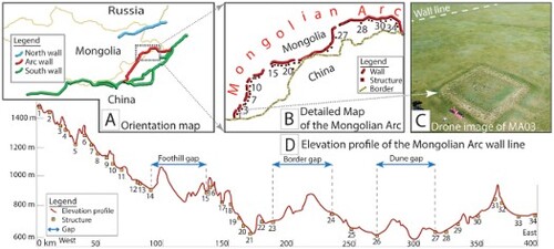
In this paper, we report on a remote sensing research and archaeological fieldwork project conducted in eastern Mongolia. The aim of this research is to provide comprehensive documentation and a preliminary analysis of a 405 km long wall section, which is part of a larger wall system in China and Mongolia. It is suggested, based on historical records, that the entire system was built sometime between the 11th and 13th centuries a.d., but the archaeological work conducted so far is insufficient to date the construction time of its different sections more accurately. We have dubbed the section analyzed in this paper the “Mongolian Arc,” in reference to an arc-shaped wall line located in the eastern Mongolian provinces of Dornod and Sukhbaatar. It extends from the primary wall line in present-day northern China and runs more or less parallel to the current border between China and Mongolia ().
Figure 1. Map delineating three distinct wall sections: the Northern Line is represented in blue, the Southern Line in green, and an extension segment of the Southern Line in red. The Mongolian Arc is the part of the red line that extend into Mongolian territory.

Figure 2. Map of the Mongolian Arc wall line marking the locations of structures and water sources along the wall line and highlighting three distinct gaps in the associated structures along the line.

The entire wall system to which the Mongolian Arc belongs has received different names in the research literature. It has been called the “Jin border trench” (金界壕), the “Jin long wall (金長城),” and the “Liao-Jin wall” (Jing Citation2006; Jing and Tiene’ 苗天娥 Citation2008; Sun Citation2010; Xie, Zhang, and Li Citation2020, 7–8). It is also one of the most enigmatic long wall and trench systems in the history of China and Mongolia. In spite of its scale and complexity (see ), it is unclear when exactly it was built, who built it, and for what purpose. It is not even clear whether the entire array of walls was built at the same time or if, as we now hypothesize, it is an accumulation of different projects built over a long period of time. Due to these uncertainties, we refer to this extensive wall system and its associated structures as the “Medieval Wall System” (MWS) (Shelach-Lavi, Honeychurch, and Chunag Citation2020; Shelach-Lavi et al. Citation2020; Storozum et al. Citation2021).
Perhaps because of the uncertainties associated with its time of construction and use, the fact that it is located in remote areas, and the fact that is not visually impressive, the MWS has received much less attention than other episodes of long wall (or Great Wall) construction in the history of this region. For example, in the authoritative work on this period in English, volume 6 of the Cambridge History of China, only one short paragraph is devoted to a schematic description of the wall (Franke Citation1994, 250). Even in books that are focused on the so-called Great Wall of China, such as Arthur Waldron’s famous book (Citation1990), the Jin wall is only mentioned in passing, without the kind of detailed discussion devoted to earlier and later episodes of wall construction. The MWS did not, however, go unnoticed by traditional Chinese scholarship and was referenced in various sources of the late imperial period. For example, the Qianlong Emperor (r. a.d. 1735–1796) mentions it in a stele erected in a.d. 1752 (Zhang Citation2004). A more detailed description is found in the work Heilongjiang waiji (External Records of Heilongjiang) by a Manchu scholar whose Chinese name was Xiqing (Citation1894, 2:2). Further studies of the “Jin border trench” emerged during the Republican period, starting with the famous studies by Wang Guowei (Citation1921).
While no comprehensive archaeological study of this wall system exists, several small-scale excavations and surveys of parts of the MWS have been conducted in recent decades (Sun and Wang Citation2009; Wang, Hao, and Liu Citation2013; Wang and Liu Citation2009; Xie, Zhang, and Li Citation2020; Yang et al. Citation2002; Zhao Citation1993). Most of these studies focus on parts of the southern lines in China, as well as on the so-called Northern Line (the “Wall of Chinggis Khan”), located in Russia and Mongolia (Kradin Citation2019). The section that is the focus of our current study, the Mongolian Arc, has not previously received serious academic attention. If mentioned at all, this wall section and its associated structures are either unrecognized or incompletely and inaccurately documented in existing literature (e.g., Baasan Citation2006; Sun and Wang Citation2009; Xie, Zhang, and Li Citation2020).
As part of the current project, our team analyzed various types of satellite images, Chinese atlases, and Soviet maps relating to the MWS and used this data to better map the Mongolian Arc and its associated structures. In July 2022, we conducted a field survey of the wall and explored its structures and layouts on the ground for the first time. The data was analyzed to examine the distribution of walls, wall gaps, and associated structures. Described below are the various methods of analysis we employed with the aim to provide an initial understanding of the nature of this wall section, including the gaps that exist in the wall line, the organization of the wall and its associated structures, and their relationship with the surrounding landscape.
Current Understanding of the Mongolian Arc
The Mongolian Arc is situated in eastern Mongolia, stretching from Sukhbaatar Province in the southwest to Dornod Province in the northeast (see ). Today, apart from the small township of Erdenetsagaan, this area is sparsely populated by small pastoral groups. It is a steppe environment where, during the summer and autumn, the land is thickly covered by grasses and is frozen and barren during the winter and spring. The mean average temperature in Dornod is 19° C. For seven months of the year, from October to April, the temperature drops below zero, and during January and February, the temperatures range between -15 and -25° C. Average annual precipitation is 245 mm, with most of it occurring between June and August. Soil accumulation is relatively shallow and concentrated in the valleys and flat lowlands, but even there, it is not deep.
The Mongolian Arc is connected to the southern lines of the MWS, which extends from the Ni’erji dam at the border between Heilongjiang and Inner Mongolia to Miaogouxiang in Wuchuan County, Inner Mongolia. The section of which the Arc is part is an extension of this wall line. The total length of the entire section is 1660 km (red line in ). This wall line is often associated with the border of the Jin dynasty (a.d. 1115–1234) (Guojia Wenwuju Citation2003; Wang Citation1921) and is believed to have been built and used during the Jin period. However, this dating has never been proven conclusively, and more archaeological and historical research is needed to support this hypothesis.
The earliest existing mapped record of the Mongolian Arc is in Soviet maps, as described in our previous paper (Storozum et al. Citation2021). These maps marked a few incomplete lines that provide some information about the approximate distribution of the wall. Similarly, Baasan (Citation2006, 30, 71–72, 90, 107–109) mentioned and recorded the beginning and the end sections of this wall. Some Chinese literature also acknowledges that the wall extends into the current territory of Mongolia and shows some of the structures along the wall (Feng Citation1991; Jia Citation1979, 178; Pang Citation1981). Other literature suggests, without concrete evidence, that the wall ends somewhere south of Buir Lake (Feng Citation2008, 51; Guojia Wenwuju Citation2003, 66–67, 96; Li Citation2009, 212, 214). Thus, although the Mongolian Arc is occasionally described, this wall section is often misrepresented as being linked to a different branch line of the southern lines in China (Li Citation2009, 214). This same mistake is even perpetuated in a recent and comprehensive book on the MWS (Xie, Zhang, and Li Citation2020, 62, 84, 92, 95, 109, 110, 122).
The first acknowledgment and precise mapping of parts of the Mongolian Arc were conducted by Pount (Citation2019). However, Donto’s results have thus far only been published as a conference proceedings paper, which only provides a preliminary introduction to this section of the wall, without details of the associated structures. In this project, we conducted a thorough analysis of satellite imagery and a field survey and have ascertained that the Mongolian Arc spans 405 km inside the border of Mongolia, and we have accurately traced its connection with the southern wall lines in China.
Methodology
Information on the locations of walls and structures along the Mongolian Arc is derived from our database and the use of the multi-method mapping approach (for details, see Storozum et al. Citation2021). Our comprehensive examination of the wall and trench situated along the Mongolian Arc employed an array of diverse tools: in the initial stage, we utilized various resources to chart the basic trajectory of the wall. After the foundational discovery phase, we procured high-resolution images from Planet Labs which enabled us to detect further segments of the wall. This approach involves the exploration of various types of satellite images including maps from Google, ESRI, ACME, and Bing, declassified CORONA images from as early as the 1960s, and real-time tasking images at submeter resolution (0.5 m) taken in April 2022 by SkySat satellite low orbit constellation for analytical services purchased from Planet Labs PBC. This imagery process included, among others, a 3-band (RGB) ortho process. Using these sources, we were able to trace the complete wall line and identify 33 structures associated with it. During the field survey, we were able to confirm an additional structure along the wall, raising the total number of structures to 34 (). Among these structures, 32 are strongly associated with the wall, and two (MA21 and MA12) are ambiguous. All the information collected in the lab and the field was georeferenced and mapped using ArcGIS Pro 3.1.1. Our dataset also includes layers related to the surrounding environment of the relevant area, including features such as wells, springs, lakes, and the topography.
Table 1. Documentation of the 34 structures located along the Mongolian Arc. CBI = cannot be identified. N/A = not available.
During the field survey, we traveled along the wall line, stopping at designated locations and selecting structures for systematic pedestrian survey and detailed investigation and measurements. We measured and documented 16 structures and surveyed an additional five designated stretches along the wall as part of the survey (see , ). The sample of sites we visited was selected so as to represent different sections of the Mongolian Arc. In each of the locations, we used a uniform set of actions and methods so that the data collected could be compared among the sites we visited, as well as with the sites only documented using remote sensing sources. In each of the sites, we measured the inner length and width of the structures, gates, and walls, and the features identified at the four corners of the structures, the upper and lower width and height of the wall sections, and the width and depth of the trench associated with these structures, whenever identifiable and applicable. We also sketched maps of the structures where necessary. All the measurements were taken using the SNDWAY SW-1500B Laser Rangefinder. Drone (DJI Mavic Pro) photos and recordings were also captured for all the structures we visited to document their current appearance, identify their layouts, and trace the wall lines from the air.
Table 2. Documentation of the five locations visited along the Mongolian Arc wall during the survey.
A botanical expert was engaged to evaluate variations in vegetation species and density, comparing the biotic environment atop the wall, along the trench, and within the broader secondary area. Upon concluding the fieldwork and analysis with these tools, we revisited our Planet SkySat satellite Ortho 3 band (RGB) imagery. This enabled us to better comprehend and scrutinize the finer details of the wall and trench, enhancing our overall understanding of the site, and to prepare for future analyses of other parts of the MWS.
In order to attain precise and consistent measurement documentation during the field survey, we evaluated several documentation tools suitable for our task, specifically testing the ESRI app ArcGIS Survey123. After weighing the respective advantages and disadvantages, we decided to develop a new app, dubbed “The-Wall.” We designed this Android-based application ourselves, and it was developed in collaboration with Peleg Computer and Programing Services. It was designed to function effectively without internet or cellphone reception, a necessary solution to the constraints of working in remote areas with very patchy and unstable reception, such as the eastern part of Mongolia. Our team was divided into specialized groups at each site: drone piloting, sherd collection, measurement data collection, and photography. With the assistance of the The-Wall app, we streamlined our on-site processes, enabling us to complete our tasks in a relatively short time and ensuring that all the necessary data was collected and documented properly.
The app was preloaded with all relevant data about the locations we intended to visit. Upon arrival at each site, the app automatically displayed the site-specific data. It leveraged the phone’s GPS to indicate the exact site coordinates and showed the date and time of data collection, as derived from the phone’s system. It also displayed the site number predefined by us and the name of the documenter derived from the smartphone. The app contained a pre-drawn sketch, enabling the documenter to input the measurement data directly onto the sketch obtained using a laser range finder (). Photographs taken through the app were systematically saved with embedded metadata in the file name, such as GPS coordinates, site name, and the documenter’s name. When we reached a location with Wi-Fi reception, The-Wall synchronized and uploaded collected data and photos to our cloud-based database. This eliminated the need for manual transcription from paper or data transfers from one device to another, significantly accelerating our data collection and uploading process.
Figure 3. The-Wall app, typical screen shots. On the left is the main entry screen; on the right is a measurement data collection screen for a structure with a pre-drawn schematic sketch and measurement input fields.

We conducted a pedestrian survey in and around each of the structures. A systematic collection procedure was applied, separating each structure and its surrounding area into five areas: the area of the structure itself and the four trapezoids’ areas, ranging from 30–50 m2, attached to the four sides of the structure. Each of these areas was assigned different collection numbers and investigated and recorded separately by one member of our team who systematically walked the area of the assigned polygon for 10–15 minutes. The borders of each of the areas were also marked and recorded in the field. The polygons were pre-drawn in a MAPS.ME app for navigation and accuracy prior to the survey. The recorded information includes survey recorders, dates, coordinates, collection numbers, surface visibility, artifact types, number of bags of collected artifacts, and descriptions of artifacts. Artifacts, mainly potsherds, were collected at the sites. However, artifacts were very scarce, and we were able to find them only at six sites. All the pottery was identified as dated to the medieval period (11th–13th centuries a.d.), but none of the sherds are indicative of any specific period within this 300 year span.
One exception to the above is the structure labeled MA21. It is rectangular in shape, unlike the other more or less square structures. It is located 17 km away from the wall line, much farther than any other structure. Most importantly, in contrast with the scarcity of objects found at all the other structures and locations we visited, many objects were revealed during our survey of this site. This site was visited by Perlee in the 1950s and again by Bayar during the 1980s. They provided a short description of the site, which they named Khaltaryn Balgas, but did not provide any dating or other relevant information (Bayar Citation1982).
MA21 is oriented more or less according to the cardinal directions (slightly tilted to north-northwest/south-southeast) (). The outer walls of the site are constructed of stones and are enclosed by a ditch. They measure 38 × 49 m and have towers at the four corners and an entrance gate at the center of the southern wall. The walls are about 1 m high from the internal level of the structure and about 2.5 m above the level of the external ditch. The internal mound, which was probably the foundation of a structure, is also rectangular in shape, some 20.5 × 25.5 m. It has a higher platform on its northern side (where the main building probably stood) and a lower part towards the south, which may have been an open court. At the southernmost part of this, just in front of the enclosure’s gate, there is a semi-circular ramp, perhaps the location of the stairs that led to the structure.
Figure 4. Drone photo of Khaltaryn Balgas (MA21).

The surface of the site, including the entire area inside the enclosure walls, as well as areas extending some 20 m around them, was literally covered with a huge quantity of glazed pottery. Those were mostly roof tiles and other construction materials, which probably represent the collapse of structures that covered the entire site (). While we could not clearly date this pottery, our current estimate is that it is from the Mongol period (a.d. 1206–1368). Therefore, we did not include structure MA21 in our analysis. Another structure, MA12, is also larger than most of the other structures and is rectangular in shape. It is only 400 m away from another structure (MA13), and thus seems redundant. While no artifacts comparable to those found on the surface of MA21 were found in or near MA12, we decided to also omit these two structures from our analysis, leaving us with a dataset of 32 structures.
Figure 5. Artifacts collected on the surface of Khaltaryn Balgas (MA21).

The Structure of the Wall, Trench, and the Enclosures
Based on our analysis of the satellite and remote sensing imaging, we selected a sample of wall sections and structures (enclosures) to be surveyed on the ground. Based on careful measurements conducted at five wall sections, we found that the walls are preserved to a maximum height of 1–1.5 m but are usually much more eroded and are barely visible above the ground level. The walls are between 2.5 m wide at the top and 13.8 m wide at the bottom and are accompanied by a trench on their outer (northern) side (see ). It should be stressed that these walls are not as impressive as the popular imagery of the “Great Wall of China” may have us assume (). Although we have yet to excavate any parts of the Mongolian Arc, our excavations of the Northern Line suggest that the main feature of these structures was the trench. At least for the Northern Line, the wall itself was not a formal construction but rather a pile of the earth excavated from the trench, which was tamped, as seen in the rammed earth (hangtu 夯土) walls of the enclosure (Shelach-Lavi, Honeychurch, and Chunag Citation2020). In fact, it seems that it is not only here but also in many other examples from the ancient world that long trenches, rather than walls, were the main feature of such monumental structures (Shelach-Lavi, Ulus, and Avni Citation2023). Our planned excavations of the Mongolian Arc line will confirm whether it is similar to our findings at the Northern Line or was perhaps more formally constructed, as the height of its preservation may suggest.
Figure 6. Drone image of a typical wall section located between structures 17 and 18. Measurements are typical based on measurements at various locations along the wall.

Our preliminary observations, made using the satellite images described above, are that, unlike the previously studied Northern Line (Shelach-Lavi, Honeychurch, and Chunag Citation2020; Shelach-Lavi et al. Citation2020), the Mongolian Arc is not a continuous line and has several noticeable gaps separating it into unconnected sections. Spanning a total length of 405 km, the Mongolian Arc includes 21 identified gap sections, adding up to 105 km, or approximately 25% of the entire Arc length. The average length of these gaps is 2.7 km, with individual gaps ranging from 0.3 km to a maximum of 17.9 km. To determine the nature of these gaps, we conducted on-the-ground surveys of selected locations along the wall line. Our primary objective was to ascertain whether these were intentional gaps—that is, areas where the wall was never built—or simply segments that have suffered substantial erosion or coverage over time. Our observations suggest that there are two types of gaps: gaps with distinct wall endpoints and gaps which are clearly the result of natural processes such as rivers, cliffs, or sand dune coverage of the wall line.
We recognized two distinct types of gaps: gaps where the wall lines do not exist and gaps where the wall exists but is not accompanied by structures. The second type, that of “structure gaps,” are concentrated in three sections (see ). 1) The “Sand Dunes Gap” located between structures 26 and 27: this gap appears to be a result of erosion and coverage, where shifting sand dunes spanning 30 km have covered portions of the wall and possibly concealed yet-to-be-identified structures. 2) The “Border Gap,” approximately 40 km between structures 23 and 24, where the wall runs parallel and proximate to the Chinese-Mongolian border, but, strangely, no associated structures were identified. Our analysis did not reveal any structures in this region, possibly due to the presence of comprehensive border fortifications, border roads, fences, and military bases that may have destroyed and covered those structures. 3) The “Mountain Foothill Gap” between structures 14 and 15: this is a genuine gap of roughly 17 km that precedes an ascent up towards a mountain range. It is intriguing given the lack of evident erosion or other justifiable reasons for the absence of a wall and structures along this section.
Our observations in the field suggest that most of the wall gaps should be classified as gaps where the wall was never built. These wall gaps are characterized by a clear demarcation where the wall descends towards the gap. Rather than gradually phasing out, as can be expected at the edges of an area affected by erosion or coverage, the end of the wall is very clear, and no traces can be identified beyond it until it reappears at the other end of the gap. In such places, there are no indications of sand coverage or reasons for fast and aggressive erosion (such as streams that cut through the wall line). Of the total identified wall gaps, 83 km are those gaps which we identify as actual gaps and 22 km are ambiguous, lacking a distinct start or end point. We suspect that these latter gaps are places where the wall may have eroded or was buried, as is the case in the Sand Dune Gap between structures 26 and 27. In future field seasons, we plan to carry out excavations and use remote sensing tools to further understand the gaps and test our hypotheses that are currently based on surface observations.
As mentioned above, we identified 34 individual structures along the Mongolian Arc wall line through our lab and fieldwork. For reasons discussed above and in order to make sure we only analyzed structures that are clearly associated with the wall line, we decided to omit two structures from the analysis, which focused on a dataset of 32 structures. These 32 structures are all rectangular enclosures surrounded by earthen walls and trenches. The structures are oriented towards the nearest section of the wall, with one corner of the rectangular enclosure pointing in the direction of the wall. Therefore, their compass orientation varies from location to location, depending on the orientation of the wall line. The enclosure walls are preserved to a height of up to 1 m and are up to 9 m wide at the bottom (though this width probably represents an accumulation of soil that eroded from the tops of the walls). Remains of stone construction were identified in the corners and walls of some of the enclosures, but we were unable to identify specific structures inside or outside the enclosure walls (). We plan to continue examining the structures through targeted excavations.
Figure 7. Drone image of structure MA03.

In general, the structures along the Mongolian Arc are smaller in size than similar structures located along the Northern Line of the MWS (Shelach-Lavi et al. Citation2020). Their areas, inside the enclosure walls, range from 650–2303 m2 (see ). The average size is 1100 m2 (STD 388 m). We were furthermore able to identify the position of the gate to the enclosure at some of the structures, usually located on their southern or southeastern sides, facing away from the wall line.
Spatial Analysis of the Mongolian Arc
The northeastern part of the Mongolian Arc is situated in a relatively flat area at an elevation of 700–800 masl. It gradually ascends a mountain range towards the southwest up to an elevation of 1200–1370 masl. The absolute elevation (above sea level) of the individual structures does not indicate an intentional selection of where the structures were placed (see more below). Rather, it reflects the general environment of the area where the wall passes.
We estimate that the 32 structures which we identified as clearly belonging to the wall system are not the full original number of structures that existed along the Mongolian Arc. Our observation of the distribution of the 32 structures identified three sections where few or no structures are found: a sand dune region at the northeastern part of the Arc; a segment running parallel and very close to the Mongolian-Chinese border, between structures MA23 and MA24 at the central part of the Arc; and, a lengthy 17 km gap between structures MA14 and MA15 (), where the wall is at the foothills just before it begins to ascends a mountain. It seems clear sections of the wall and possibly its associated structures were buried under the sand in the sand dunes region. Along the Chinese-Mongolian border, the wall is located on the Mongolian side of the border, and the probable location of the structures is on the Chinese side of the border, which has been heavily disturbed by Chinese border fortifications, including fences, roads, and surface flattening. For the third section, before the wall ascends a mountain slope, we could not find a natural or anthropogenic reason for wall erosion. This is also the segment where the longest gap in the wall line itself exists.
Figure 8. Elevation profile of the Mongolian Arc, with the locations of structures and gaps.

Our analysis shows that most structures are located relatively close to the wall, which strongly suggests their association with it and their function as part of the wall system. The distance between the structures and the wall line is between 46 and 4474 m. The average distance is 1308 m (median 843 m). The distances between the structures are relatively short. To calculate those distances, we omitted MA21, which does not appear to be associated with the other structures. We also omitted from this specific calculation structure MA12, which is close to MA13 (400 m). We were left with 32 structures, or 31 distances between structures. These distances range between 2.9 and 53.6 km (average 11.87 km; median 7.8 km; standard deviation 12.32 km) (). Most of the distances range between 3 and 8 km, with a few around 15 km, but the calculated mean and standard deviation are larger because of three unusually large gaps in the location of the structures. These structure gaps are the same three large gaps described above: 1) on the plain just before the wall ascends into the mountains; 2) where the wall runs very close to the Chinese-Mongolian border; and, 3) where the wall crosses an area of sand dunes. To simulate what we believe were the actual distances (or the distances originally planned by the builders of the wall) between structures, we omitted these three largest gaps from the dataset and recalculated. The new results are distances between 2.9 and 16.7 km, with an average distance of 8.19 km (standard deviation 3.81 km). By omitting the three gaps, the standard deviation decreased significantly, indicating that the data is now more concentrated around the mean distance between the structures. It seems, therefore, that the structures along the Mongolian Arc were distributed with an average distance of 8 km between them. This is closer than the observed distances along the Northern Line, where the distances between structures (clusters of structures) are between 8 and 29 km (Shelach-Lavi et al. Citation2020). The reduced spacing between structures suggests the potential need for enhanced security measures along this wall section of the Mongolian Arc.
Figure 9. A) Distances between structures in sequence, from east to west, showing 3 gaps. B) Constrained Kernel Density Estimation (KDE) plot representing the distribution of distances between forts, excluding the three noted gaps.

Identifying the visibility of the 32 structures, or, in other words, what portion of the surrounding environment could be seen from each structure and whether they could see each other and the wall line, is important for a better understanding of their function. To address those questions, we used viewshed and observer points analyses. These GIS tools are commonly used in archaeology, especially in regional and landscape archaeology (Conolly and Lake Citation2006, 225–233; Malaperdas Citation2021). Viewshed analysis is used to assess and visualize the observable area from one or multiple vantage points of a specific geographical region. The observer points tool is used to determine which observer locations are visible from any given point within the study area. In , we present the outcomes of both these analyses. The viewshed analysis was executed for each individual structure along the wall. We employed all the structures as the input dataset in this analysis. The resulting raster delineates precisely which observer points are visible from each location and quantifies how many observers can be seen from each position. These analyses were conducted using the ArcGIS Pro software Spatial Analyst tool box (version 3.1.3) and a 90 m per pixel digital elevation model (SRTM).
Figure 10. Viewshed and observer point analyses: colored locations are areas that can be seen from at least one structure along the Mongolian Arc. Inset map (bottom right) represents the results of an observer point analysis of the 34 structures along the entire length of the Mongolian Arc. The larger map shows the result of a viewshed analysis for structures 1–14.

The analysis indicates that the distance and extent of the line-of-sight varied among the structures, but our general observation is that, in most cases, the structures did not have very extensive visual command over their environment, including the ability to see each other and to watch over the wall line (see , inset map). Structures located in the southeasternmost section of the wall, between structures MA01 and MA14, are situated at locations that are unfavorable to having a line of sight. While these structures are not located at a great distance from each other, most of them cannot see or be seen from neighboring structures (see , large map). MA11 is an exception, as its viewshed covers an extensive area, including the wall line and neighboring structures. The analysis also shows that the structures’ sight coverage of the wall line and areas beyond it is very limited, leaving considerable parts of wall unseen from any of the structures. This poor command of the lines of sight is explained by the location of the structures at relatively low points in the environment, as exemplified by a transection of the location of enclosures MA02, MA03, and MA05 (). Nearly all the structures in this southeasternmost section are positioned between the wall to their east and a stream to their west. This location provided flat spaces upon which the structures could be easily built but is perhaps also related to locations where there were easy passes across the streams.
Figure 11. Three examples of elevation profiles illustrating the positioning of three structures—MA02, MA03, and MA05—and the wall within their surrounding spatial environments. The topmost figure presents a 3D spatial layout of MA02 in its surroundings, derived from the integration of remote sensing imagery and a digital elevation model (DEM).

The findings for structures MA12–MA18 are similar to those of the first (southernmost) section. Structures MA19–MA29 have a wider and more extensive line of sight but still only command the wall partially. Interestingly, analysis of the section between MA19 and MA26 shows an unusual pattern: the sight lines from most of the structures cover the areas inside of the wall instead of towards and outside of it. The only section of the Mongolian Arc where the structures have a relatively extensive line of sight covering a longer section of the wall is between MA30 and MA34, perhaps because this is a relatively flat area.
Overall, this topographic placement of the structures is similar to the patterns we observed in the Northern Line (Shelach-Lavi et al. Citation2020). The structures (or enclosures) are located in places that are relatively low in the landscape. These placements are not favorable for combat and for defending against military threats. However, they may be associated with the movement of people and animal herds along natural passes and streams. The locations appear more suited to functions such as tax collecting and general supervision of the movement of the civilian population in and out of the walled area, as well as possibly preventing small-scale intrusions and raids.
Water is one of the most crucial resources for both humans and animals in the steppe environment. Analyzing the distribution of permanent water sources and their association with the structures in question is, therefore, important. The region traversed by the Mongolian Arc has many small streams, but these are seasonal and most were probably dry in the winter. Lakes in this area are salty and not suitable for drinking and, thus, their location is not relevant to the location of the structures. Currently, the only stable sources of drinking water in this area are natural springs, along with wells that reach the relatively high underground water level. Plotting the distribution of these sources (identified on Russian and Mongolian maps) shows that many of them are located very close to the wall line (see ). It should be noted that we did not find any definitive evidence of wells dug during ancient times. However, the spatial distribution of the structures suggests that springs and wells were the main water sources available to the people who built and manned the Mongolian Arc. Perhaps this was another reason the structures were positioned at low elevations where the underground water level is close to the surface and where it is easier to dig wells.
Discussion
The present investigation of the Mongolian Arc is part of our ongoing effort to better understand the huge array of walls, trenches, and structures that we refer to as the Medieval Wall System. As mentioned at the beginning of this paper, the MWS is a highly complex construction that is poorly understood and lacks thorough study. Our long-term research agenda, funded by the European Research Council (ERC), focuses, on the one hand, on applying a multidisciplinary approach that uses various methods of data acquisition and analysis in an attempt to comprehensively document the entire MWS. Because of their extensive spatial dimensions, archaeological research of long walls and other types of linear border markers presents unique methodological and analytical problems. New methodologies introduced to archaeology in recent years, such as satellite imaging, remote sensing, and 3D modeling, allow for better mapping and novel understandings even of well-known and intensively studied monuments such as the Roman limes (Bachagha et al. Citation2020; Casana, Goodman, and Ferwerda Citation2023) or the Great Wall of Ming China (Li, Tuo, and Zhang Citation2023). Our research on the highly complex and much less studied MWS also incorporates such new methods (Storozum et al. Citation2021), but we believe that this broad approach should be complemented with on-the-ground truthing and in-depth research and analysis of specific wall sections and targeted excavations at individual sites and locations.
One of the strategies we adopted in tackling the massive MWS monument is to compare case studies of its different sub-sections. We previously conducted surveys and excavations along the Northern Line and have now shifted our focus to the Mongolian Arc, which is part of the Southern Line (but does not necessarily represent all parts of this complex line). At this stage, comparing these two wall sections allows us to identify and study the overall similarities and differences that may be associated with local geographic and ecological conditions and/or with different periods of construction and with different functions.
One of the major differences that we have observed between the Northern Line and the Mongolian Arc is the large gaps identified in the structures that accompany the wall line of the latter. Our field observations suggest that these gaps were not caused by natural geomorphological processes but, in most cases, are locations where walls were never built in the first place. As we currently cannot fully explain the functions of the gaps or the reasons for their location, more work is needed in order to develop a better working hypothesis. Currently, it seems that these gaps could have undermined the effective functions of the wall system. Each of the gaps is too wide to have been designed for the passage of people, so we do not think this was their intended purpose.
One possible explanation for the gaps, which were points of vulnerability in the system, is that the Mongolian Arc was hastily built during the final years of the Jin dynasty as a defense against the expected invading Mongol armies. This explanation was presented by the eminent Chinese historian Wang Guowei some 100 years ago (Wang Citation1921) and has remained popular among historians and archaeologists of this period ever since. The gaps we identified in our survey might be the first archaeological evidence in support of this hasty wall building hypothesis. As part of our project, we are systematically scrutinizing relevant historical texts to better understand the various issues related to the context of the MWS construction, its possible functions, and other related questions. Primary among the sources we are analyzing are the official histories of the Liao dynasty (Liaoshi 遼史) and the Jin dynasty (Jinshi 金史). While the Liaoshi contains almost no information directly pertaining to wall construction and the digging of trenches, the Jinshi is a much richer source in this respect. It describes several campaigns of wall construction that were started shortly after the dynasty was established and accelerated towards its demise. While the descriptions in the Jinshi cannot be correlated with specific corresponding sections of the Mongolian Arc, they raise important issues that could be applied to our study. For example, the Jinshi describes debates in the Jin court about the usefulness of constructing walls and border trenches and highlights the fiscal, labor, climate, and logistical challenges that impeded the efficient construction of walls and trenches. An intriguing section (Jinshi Citation1995, 24:563–564) highlights the emperor’s dissatisfaction with the quality of the wall and garrisons, leading him to order an inspection in a.d. 1181. Setbacks in the delivery of vital food supplies due to famine likely also resulted in construction delays. The Jinshi (Citation1995, 24:563–564) also describes the detrimental impact of weather conditions, specifically the fact that newly-dug trenches were leveled by sandstorms within a short time.
Most relevant to this paper, perhaps, is a memorandum presented to the Jin court around the year a.d. 1200 (Jinshi Citation1995, 93:2064). The memorandum discusses a defensive wall section of about 300 km built in haste (cupo促迫, “great hurry”). Although the wall section discussed here is probably not the Mongolian Arc part of the wall, we suggest that the Mongolian Arc was likewise built in haste. Considering the historical context of a.d. 1200, just before the rapid Mongolian invasion of Jin territories, it seems plausible that the rush to construct trenches and walls resulted in the gaps we find today. The fact that the longest gap in the wall, between structures MA14 and MA15, is also where we did not find any structures for a relatively long stretch, can also support this hypothesis. Our ongoing archaeological exploration and dating might substantiate this hypothesis.
Our spatial analysis of the structures along this line reveals a different pattern, which appears to disprove the military purpose of the Mongolian Arc. Unlike the Northern Wall line, where structures are grouped together in clusters, with each cluster located around 20–30 km from the next, the structures along the Mongolian Arc line are individually placed but in closer proximity to each other (typically around 8 km apart). This denser arrangement might suggest a defensive function. However, our viewshed analysis revealed that the structures have limited visibility and are unable to establish visual communication with one another. This is especially clear in the southern part of the Arc, which was built northwest of a long mountain ridge (see , ). This placement away from the ridge rather than on top of it, where the wall and associated structures would have broader sight coverage and control over their surroundings and would have been easier to defend, goes against a military logic for the wall. This positioning suggests that their primary function was not military or defensive in nature but rather that it was associated with controlling the movement of people and their herds, maybe with other civilian functions such as taxation. Nonetheless, if the function was to defend against the Mongolian invasions (or even against smaller scale raids), perhaps the positioning of the wall and its structures was affected by consideration of convenience and cost. As mentioned, soil accumulation in this region is very limited, so the most convenient places to excavate trenches and build walls and earthen enclosures, especially if expediency is an issue, is in the low and relatively flat areas where soil has accumulated. Those areas also have better access to permanent sources of drinking water.
This paper presents the first comprehensive documentation of the Mongolian Arc and provides a preliminary understanding of the organization of this section of the wall through spatial analysis. The insights and conclusions drawn from our analysis should be considered hypotheses to be tested in future archaeological research. We are currently making plans for the next stage of field research, which will build upon the results reported here and aims to test some of our hypotheses. During the upcoming field season, our objectives include conducting test excavations at two of the structures and the wall line itself. Through these excavations, we hope to gain a better understanding of their features and structures, determine the construction dates and duration of use, and shed light on the activities of the people stationed in these enclosures. Additionally, we are planning to employ remote sensing equipment such as multispectral photography and magnetic susceptibility, as well as geological coring, to further investigate the gaps observed along the wall line. We anticipate that these endeavors, combined with subsequent analysis of samples obtained from the excavations, will significantly advance our understanding of the Mongolian Arc and, more broadly, the MWS.
Geolocation Information
The Mongolian Arc is in present-day eastern Mongolia, starting from Dornod Province, where it crosses from China into Mongolia (46.69419, 118.7072) in the northeast, and ending in Sukhbaatar Province, where it crosses from Mongolia back into China (45.3909, 115.10779) in the southwest.
Conflict of Interest
The authors declare no conflict of interests.
Acknowledgments
This project received funding from the European Research Council (ERC) under the European Union’s Horizon 2020 research and innovation program (“The Wall” project, grant agreement No. 882894).
Additional information
Notes on contributors
Ying Tung Fung
Ying Tung Fung (Ph.D. 2022, Oxford University) is a post-doctoral fellow of The Wall project at the Hebrew University. Before coming to the Hebrew University, she worked on the Late Neolithic site of Shimao, located in northwestern China.
Angaragdulguun Gantumur
Angaragdulguun Gantumur is a Ph.D. candidate at the Department of Asian Studies, The Hebrew University. He is part of The Wall project and his main interest are in the fields of regional archaeology, GIS analysis, and the use of remote sensing in archaeology.
Ido Wachtel
Ido Wachtel (Ph.D. 2018, The Hebrew University) is a post-doctoral fellow, Martin Buber Society of Fellows, at the Hebrew University. His research interests include Bronze and Iron Age archaeology of northern Israel, regional survey methods, and GIS analysis.
Amartuvshin Chunag
Amartuvshin Chunag (Ph.D. 2004, National University of Mongolia) is a professor at the Department of Archaeology and Anthropology, National University of Mongolia, Ulaanbaatar, Mongolia. His research interests include the emergence of social complexity among nomadic groups, the study of mortuary processes, and the preservation of steppe nomadic heritage. His most recent monograph is Archaeological Landscape of the Gobi: Sites of the Khanbogd Soum (Ulaanbaatar, 2019).
Zhidong Zhang
Zhidong Zhang is a Ph.D. candidate at the Department of Islamic and Mideastern Studies, Hebrew University. He is analyzing texts in Arabic, Persian, and Classical Chinese. His research focus is the Islamization of Central Asia and the contacts between China and Central Asia.
Or Fenigstein
Or Fenigstein is an MA student at the Institute of Archaeology, the Hebrew University. She is specialized in spatial analysis of societies living in arid areas.
Dan Golan
Dan Golan is an independent scholar affiliated with the Department of Asia Studies and The Wall project at the Hebrew University. He is specialized in digital humanity tools, including AI and machine learning, the use of large-scale databases, GIS, and graphic programs.
Gideon Shelach-Lavi
Gideon Shelach-Lavi (Ph.D. 1996, University of Pittsburgh) is Professor at the Department of Asian Studies, the Hebrew University, Israel. His research is focused on the development of complex societies in China and Mongolia. He is the director of the ERC-funded project “The Wall: People and Ecology in Medieval Mongolia and China.” Shelach-Lavi’s recent book, The Archaeology of Early China: From Prehistory to The Han Dynasty, was published by Cambridge University Press (2015).
References
- Baasan, T. 2006. Čingisiin Dalan Gej yu ve? (What are the Dikes of Chinggis?). Ulaanbaatar: ADMON LLC.
- Bachagha, N., X. Wang, L. Luo, L. Li, H. Khatteli, and R. Lasaponara. 2020. “Remote Sensing and GIS Techniques for Reconstructing the Military Fort System on the Roman Boundary (Tunisian Section) and Identifying Archaeological Sites.” Remote Sensing of Environment 236: 111418. doi:https://doi.org/10.1016/j.rse.2019.111418.
- Barfield, T. J. 1989. The Perilous Frontier: Nomadic Empires and China. Oxford: Oxford University Press.
- Bayar, T. 1982. 1982 онд Сүхбаатар аймагт ажилласан археологийн шинжилгээний экспедицийн тайлан (Report of the 1982 Archaeological Research Expedition to Sukhbaatar Province). Ulaanbaatar: Institute of Archaeology, Mongolian Academy of Sciences.
- Becker, J. 2021. “Speaking to the Wall: Reconceptualizing the US–Mexico Border “Wall” from the Perspective of a Realist and Constructivist Theoretical Framework in International Relations.” Journal of Borderlands Studies 36 (1): 17–29.
- Ben-Ze’ev, E., and N. Gazit. 2020. “The Fickle Zone: Borderland and Borderlanders on the Egyptian-Israeli Front.” Journal of Borderlands Studies 37 (5): 1025–1045.
- Casana, J., D. Goodman, and C. Ferwerda. 2023. “A Wall or a Road? A Remote Sensing-Based Investigation of Fortifications on Rome's Eastern Frontier.” Antiquity, 1–18. doi:10.15184/aqy.2023.153.
- Conolly, J., and M. Lake. 2006. Geographical Information Systems in Archaeology. Cambridge: Cambridge University Press.
- Di Cosmo, N. 2002. Ancient China and its Enemies. Cambridge: Cambridge University Press.
- Feng, Y. 冯永谦. 1991. “Jin Changcheng (金长城The Jin Great Wall).” In Dongbeiya Lishi yu Wenhua (东北亚历史与文化 History and Culture of Northeast Asia), edited by Z. Zhili (张志立), and W. Honggang (王宏刚), 45–87. Liaoning: Liaoshen shushe.
- Feng, Y. 冯永谦. 2008. “Jin Changcheng Xiuzhu Niandai Bian (金长城修筑年代辨 Dating the Construction of the Jin Great Wall).” Dongbei Shidi (东北史地 3: 46–56.
- Franke, H. 1994. “The Chin Dynasty.” In The Cambridge History of China: Vol. 6. Alien Regimes and Border States, 907-1368, edited by H. Franke, and D. C. Twitchett, 215–320. Cambridge: Cambridge University Press.
- Guojia Wenwuju 国家文物局. 2003. Zhongguo Wenwu Dituji Neimenggu Zizhiqu Fence (中国文物地圖集 內蒙古自治區分冊Atlas of Chinese Cultural Relics Inner Mongolia Autonomous Region). Xi’an: Xi’an Ditu Chubanshe.
- Hill, D. 2020. “Offa’s and Wat’s Dykes.” Offa’s Dyke Journal 2: 141–159.
- Huang, R., and J. Needham. 1974. “The Nature of Chinese Society: A Technical. Interpretation.” East and West 24 (3-4): 381–401.
- Isaac, B. 1988. “The Meaning of the Terms Limes and Limitanei.” Journal of Roman Studies 78: 125–147.
- Jia, Z. 贾洲杰. 1979. “Jindai Changcheng Chuyi (金代长城初议 Preliminary Discussion of the Jin Great Wall).” Neimenggu Daxue Xuebao (內蒙古大学学报) 3 (4): 170–178.
- Jing, A. 景爱. 2006. Zhongguo Changcheng Shi (中国长城史 History of the Chinese Great Wall. Shanghai: Shanghai Renmin Chubanshe.
- Jing, A. 景爱, and M. Tiene’ 苗天娥. 2008. “Liao Jin Bianhao yu Changcheng (辽金边壕与长城The Great Wall and Border Markers of the Liao and Jin).” Dongbei Shidi (东北史地) 6: 18–31.
- Jinshi (Toqto’a脫脫). 1995. Jinshi 金史 (History of the Jin Dynasty). Beijing: Zhonghua Shuju.
- Khosravi, S. 2019. “What Do We See If We Look at the Border from the Other Side?” Social Anthropology/Anthropologie sociale 27 (3): 409–424.
- Koca, B. T. 2019. “Bordering Practices Across Europe: The Rise of “Walls” and “Fences”.” Migration Letters 16 (2): 183–194.
- Kradin, N. 2019. The Great Wall of Khitan: North Eastern Wall of Chinggis Khan. Moscow: Nauka –Vostochnaya Literatura.
- Lattimore, O. 1937. “Origins of the Great Wall of China: A Frontier Concept in Theory and Practice.” Geographical Review 27 (4): 529–549.
- Li, Y. 李逸友. 2009. “Jinjiehao: Bi Changcheng Geng Chang (金界壕: 比长城更长 Jin Border Trench: Longer Than the Great Wall).” In Jin Changcheng Yanjiu Lunji (金长城研究论集 Collection of Research on the Jin Great Wall), edited by S. Wenzheng, and W. Yongcheng, 210–215. Jilin Wenshi Chubanshe: Jilin.
- Li, Z., X. Tuo, and M. Zhang. 2023. “Types and Historical Roles of Secret Gates: A New Understanding of the Ming Great Wall Based on a Digital Heritage Survey.” Journal of Asian Architecture and Building Engineering 22 (2): 842–860.
- Malaperdas, G. D. 2021. “Practical Methods of GIS for Archaeologists: Viewshed Analysis – The Kingdom of Pylos Example.” Geoplanning: Journal of Geomatics and Planning 8 (1): 1–22.
- McAtackney, L., and R. H. McGuire. 2020. Walling In and Walling Out: Why are we Building New Barriers to Divide Us? University of New Mexico Press.
- Nokandeh, J., E. W. Sauer, H. O. Rekavandi, T. Wilkinson, G. A. Abbasi, J.-L. Schweninger, M. Mahmoudi, D. Parker, M. Fattahi, and L. S. Usher-Wilson. 2006. “Linear Barriers of Northern Iran: The Great Wall of Gorgan and the Wall of Tammishe.” Iran 44: 121–173.
- Pang, Z. 庞志国. 1981. “Jin Dongbeilu, Linhuanglu Jilinsheng Duan Jiehao Bianbao Diaocha (金东北路、临潢路吉林省段界壕边堡调查Survey of the Northern Line and Linhuang Line of the Jin Border Trench in Jilin Province).” In Zhongguo Changcheng Yiji Diaocha Baogao Ji (中国长城遗迹调查报告集 Collection of Reports on the Chinese Great Wall), edited by W. B. Weiyuanhui (文物编辑委员会), 84–92. Beijing: Wenwu Chubanshe.
- Pines, Y. 2018. “The Earliest ‘Great Wall’? Long Wall of Qi Revisited.” Journal of the American Oriental Society 138 (4): 743–762.
- Pount, D. D. 2019. “Who Built the ‘Wall in the North’ and What Does Chinggis Khan Have to do with it?” Proceedings of the 13th International Mongolian Studies Conference. Washington D.C. https://www.academia.edu/66108737/Who_built_the_Wall_in_the_North_and_what_does_Chinggis_Khan_have_to_do_with_it.
- Sauer, E. W., J. Nokandeh, K. Pitskhelauri, and H. O. Rekavandi. 2017. “Innovation and Stagnation: Military Infrastructure and the Shifting Balance of Power Between Rome and Persia.” In Sasanian Persia: Between Rome and the Steppes of Eurasia, edited by E. W. Sauer, 241–268. Edinburgh: Edinburgh University Press.
- Shelach-Lavi, G., W. Honeychurch, and A. Chunag. 2020. “Does Extra-Large Equal Extra-Ordinary? The ‘Wall of Chinggis Khan’ from a Multidimensional Perspective.” Humanities and Social Sciences Communications 7 (1): 1–10.
- Shelach-Lavi, G., T. Ulus, and G. Avni. 2023. “Insights from a Recent Workshop on Walls, Borders, and Frontier Zones in the Ancient and the Contemporary World.” Offa’s Dyke Journal 5: 13–18.
- Shelach-Lavi, G., I. Wachtel, D. Golan, O. Batzorig, C. Amartuvshin, R. Ellenblum, and W. Honeychurch. 2020. “Medieval Long-Wall Construction on the Mongolian Steppe During the Eleventh to Thirteenth Centuries AD.” Antiquity 94 (375): 724–741.
- Storozum, M., D. Golan, I. Wachtel, Z. Zhang, J. S. Lotze, and G. Shelach-Lavi. 2021. “Mapping the Medieval Wall System of China and Mongolia: A Multi-Method Approach.” Land 10 (10): 997.
- Sun, W. 孙文政. 2010. “Jin Changcheng Yanjiu Gaishu (金长城研究概述Summary of Research on the Jin Great Wall).” Zhongguo Bianjiang Shidi Yanjiu (中国边疆史地研究) 20 (1): 139–147.
- Sun, W. 孙文政, and Y. Wang 王永成, eds. 2009. Jin Changcheng Yanjiu Lunji Sheng (金长城研究论集Collected Research Papers on the Jin Great Wall). Jilin Wenshi Chubanshe: Jilin.
- Waldron, A. 1990. The Great Wall of China: From History to Myth. Cambridge: Cambridge University Press.
- Wang, G. 王国维. 1921. Jin Jiehao kao (金界壕The Border Trench of Jin). Beijing: Zhonghua Shuju.
- Wang, Y. 王禹浪, B. Hao 郝冰, and J. Liu. 刘加明. 2013. “Nenjiang Liuyu Liao Jin Gucheng de Fenbu yu Chubu Yanjiu (嫩江流域辽金古城的分布与初步研究Preliminary Research on the Distribution of Walls from the Liao and Jin Period in the Nenjiang River Basin).” Ha’erbin Xueyuan Xuebao (哈尔滨学院学报) 34 (7): 1–15.
- Wang, Y. 王禹浪., and G. Liu. 刘冠缨 2009. “Heilongjiang Diqu Jindai Gucheng Fenbu Shulue (黑龙江地区金代古城分布述略A Brief Introduction to the Distribution of Jin Dynasty Ancient Walls in the Heilongjiang Area).” Ha’erbin Xueyuan Xuebao (哈尔滨学院学报) 30 (10): 1–26.
- Xie, D. 解丹., Y. Zhang 张玉坤, and Y. Li. 李严. 2020. Jin Changcheng Fangyu Tixi yu Junshi Juluo (金长城防御体系与军事聚落Defense System and Military Settlements of the Jin Great Wall). Beijing: Zhongguo Jianzhu Gongye Chubanshe.
- Xiqing 西清 (Sirin Gioro). 1894. Heilongjiang Waiji (黑龙江外记External Records of Heilongjiang). Shanghai: Guangfangyuan Guan.
- Yang, M. 2017. “The Trump Wall: A Cultural Wall and a Cultural War.” Lateral 6 (2),.
- Yang, X. 杨星宇, J. Feng 冯吉祥, W. Ao 敖卫东, and Q. Ao. 奥奇. 2002. “Ni’erji Shuili Shuniu Gongchengqu nei Jindai Jiehao Fajue Jianbao (尼尔基水利枢纽工程区内金代界壕发掘简报Brief Report on the Excavation of the Jin Dynasty Border Trench in the Nierji Water Control Project Area).” Neimenggu Wenwu Kaogu (内蒙古文物考古) 26 (1): 115–118.
- Zhang, S. 张淑敏. 2004. “Gu Changcheng Shuo: Bei de Lishi Jiazhi (《古长城说》碑的历史价值Explaining the Old Great Wall: The Monument's Historical Value).” Chengdi Minzu Zhiye jJshu Xueyuan Xuebao (承德民族职业技术学院学报) 2004 (02): 98–100.
- Zhao, Y. 赵玉明. 1993. “Lingdong Jindai Changcheng Diaocha (岭东金代长城调查Survey of the Great Wall of the Jin Dynasty in Liaodong).” Neimenggu Shehuai Kexue (内蒙古社会科学) 1: 61–67.