
ABSTRACT
Plans are underway to greatly increase rates of groundwater extraction from the Northern Territory’s Cambrian Limestone Aquifer (CLA), particularly above the Beetaloo sub-basin, to allow expansion of shale gas and agricultural industries. We analyse current groundwater regulations in the NT, and the state of knowledge regarding key aspects of the region’s hydrogeology and values sustained by groundwater. We find that the current rules governing the administration of groundwater licencing in areas without a Water Allocation Plan (WAP) – the Top End and Arid Zone rules – are poorly suited to protect ecological, Indigenous socio-cultural and other water use values. These rules (as currently applied) allow the depletion of substantial groundwater storage in areas that fall within the ‘arid zone’ (as defined in NT policy). Such depletion risks the reduction or loss of groundwater flows to ecosystems and stygofauna habitat and reduced throughflow of groundwater between different regions, within the highly connected CLA system. This may disrupt water flows that sustain local livelihoods and those that are integral to Indigenous peoples’ beliefs and cultural practices. The new WAP that applies over much of the Beetaloo sub-basin (Georgina-Wiso WAP) is also deficient in key areas. It has failed to comply with national water policy, in that no substantive steps have been taken to understand Indigenous cultural and ecological values sustained by groundwater prior to setting an Estimated Sustainable Yield. A more precautionary, inclusive approach to determining groundwater regulations would involve a) setting of conservative water extraction limits combined with trigger levels for ecosystem protection and b) co-management in partnership with Aboriginal peoples, with both consultation and decision-making processes that recognise their inherent rights and interests in water. This will be critical to avoiding long-term environmental and socio-cultural harm from over-extraction of groundwater.
1. Introduction
Recent water licencing decisions in Australia’s Northern Territory have triggered public controversy, debate, and legal review (e.g. Jonscher Citation2022; O’Donnell et al. Citation2022; Water Resources Review Panel Citation2021). The heightened attention has particularly focussed on groundwater, to which irrigation and oil and gas interests are currently seeking greatly increased access to underpin major expansion plans (Fitzgerald Citation2022; Scientific Inquiry into Hydraulic Fracturing in the Northern Territory Citation2018).
Much of the pressure to develop groundwater is within the area underlain by the Beetaloo sub-basin, a thick sequence of sedimentary rocks which host significant oil and gas deposits (Evans et al. Citation2020). Overlying the Beetaloo and intervening geological sequence is the Cambrian Limestone Aquifer (CLA), a large inter-connected karst system, which hosts substantial quantities of high-quality groundwater (Currell and Ndehedehe Citation2022; Knapton Citation2020). Development of shale gas has received support from the federal and Northern Territory governments; however, viability of the industry is contingent upon access to water for sand washing and hydraulic fracturing. Simultaneously, as part of a long-standing commitment to developing the north, governments are encouraging agri-business interests (e.g. irrigated cotton and horticulture) to establish large-scale operations. These plans, which would involve major increases in rates of groundwater extraction from the CLA, have met with opposition from many quarters, particularly Indigenous organisations and conservation groups, who are concerned about over-extraction and pollution (Fitzgerald Citation2022).
Groundwater flows underpin ecological, cultural, and economic values throughout the NT (Barber and Jackson Citation2011; Currell and Ndehedehe Citation2022; Pusey et al. Citation2020). They sustain the episodic rivers that Jackson et al. (Citation2008) identified as sites of considerable cultural significance to both Indigenous traditional owners and the settler population. Most water supplies, e.g. stock water for pastoral stations and small community supplies, are sourced from CLA groundwater bores, and many tourist enterprises depend on springs and dry season flows sourced from the aquifer. It is thus imperative that groundwater is managed sustainably and equitably, in ways that aspire to ensure these values are maintained, and all stakeholders are afforded meaningful participation. The rights and interests of Indigenous peoples warrant particular attention because as with surface water, groundwater is governed by rich and complex Indigenous institutions of ownership and management (Jackson et al. CitationIn Press; Langton Citation2002).
The Northern Territory has been described as a ‘hydrological frontier’ (Langton Citation2002), within which water licencing and allocation rules and processes lag behind national standards, such as the National Water Initiative (NWI), and which – according to O’Donnell et al., (Citation2022), perpetuate a system of colonial extraction that disproportionately disadvantages Indigenous traditional owners. As development pressures on groundwater increase in the NT, progress on water allocation plans (WAPs) has been slow, and to date most groundwater licences have been granted in areas without WAPs, using ‘contingent’ allocation rules (see Section 3).
Despite detailed recommendations from the 2017 Scientific Inquiry into Hydraulic Fracturing chaired by The Hon Justice Rachel Pepper (hereafter referred to as the Pepper Inquiry), including the need for more robust water planning processes and resolution of major scientific knowledge gaps prior to the establishment of a shale gas industry, progress towards these objectives has been limited. The NT government’s Strategic Regional Environment and Baseline Assessment framework (SREBA) was designed to address the knowledge gaps identified in the Pepper Inquiry (Northern Territory Government Citation2020). The SREBA was completed and released in May 2023 (DEPWS Citation2022); however, significant gaps identified by the Pepper Inquiry – such as understanding inter-aquifer connectivity and social impacts on Indigenous peoples, remain un-addressed (Currell and Ndehedehe Citation2023; Ritchie Citation2023).
Considerable uncertainty remains regarding key aspects of the CLA (and wider NT) groundwater resources, such as the timing, mechanisms and rates of groundwater recharge and discharge, the dependence of these flows on climatic and other variables, the level of connectivity between different aquifer units and (sub-)basins, and the tolerance of ecosystems – both above ground and subterranean – to changes in groundwater flows, levels, and quality (Currell and Ndehedehe Citation2022, Citation2023; Evans et al. Citation2020; Northern Territory Government, Citation2021).
The process by which water allocation plans have been developed has also been criticised for lacking transparency, providing limited opportunities for public participation, for facilitating piecemeal assessments of environmental risks and failing to mitigate risks to Indigenous communities (Fitzgerald Citation2022; Ritchie Citation2023). The scientific rationale for allocating large volumes of groundwater from the CLA to industry has been disputed and subjected to legal challenge (e.g. Water Resources Review Panel Citation2021). In combination, these governance issues create a significant risk of harm to the groundwaters of the NT, the values and uses they sustain, and the rights and interests of Indigenous peoples.
The main objectives of this paper are to analyse current groundwater regulations in the NT, the state of knowledge regarding the region’s hydrogeology and values sustained by groundwater, and risks to these values should rates of extraction increase under current management arrangements. We begin with a summary of contextual information about the study area (Section 2). We define this as the CLA, particularly within the Beetaloo Strategic Regional Environmental and Baseline Assessment (SREBA) area (), the focus area for addressing water knowledge gaps identified in the Pepper Inquiry. We then review the water licencing and allocation regime in the Northern Territory and analyse risks to groundwater-supported values inherent in this regime (Section 3). Our focus is particularly on rules that apply to licencing decisions outside of water allocation plan areas – which includes significant parts of the SREBA area – as well as the recently announced (November 2023) Georgina Wiso Water Allocation Plan (Northern Territory Government Citation2023c), which overlaps with the southern SREBA area. We then summarise key values at stake which may be at risk of harm if increased groundwater extraction is permitted under the current management regime (Section 4). Finally, we provide recommendations to help chart a path towards effective, equitable, and sustainable co-management of groundwater (Section 5).
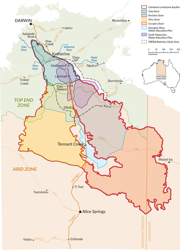
Figure 1. Location of the study area showing extent of the Cambrian Limestone aquifer (CLA) and underlying Beetaloo basin, the boundary between Top End and Arid zones as defined in the NT water allocation framework, and relevant water allocation plan areas. SREBA = Strategic Regional environmental and Baseline Assessment area, as defined in Northern Territory Government (Citation2020).
2. Study/focus area
2.1. Geographic setting including social context
The Cambrian Limestone Aquifer (CLA) underlies approximately 28,000 km2 of the Northern Territory (). The subtropical climate of alternating wet and dry seasons means that surface water availability is highly seasonal and, in many places, limited. Average yearly precipitation increases from approximately 350 mm in the south (near Tennant Creek) to ~1200 mm at the aquifer’s northernmost extent (between Darwin and Katherine). Potential evapotranspiration follows an opposing trend, decreasing from ~3600 mm in the south to ~2400 mm in the north. Most rivers flow freely, without major water storage or harvesting infrastructure. CLA groundwater, extracted from bores, supports community water supplies and the pastoral industry, as well as limited irrigated agriculture (Northern Territory Government Citation2017). The region is characterised by low population density with only two large towns, Katherine and Tennant Creek, which are also largely reliant on groundwater.
Numerous Indigenous language groups hold non-exclusive native title rights to substantial tracts of land throughout this region. Approximately 10% of the SREBA area is held as Aboriginal freehold title under Commonwealth land rights legislation (DEPWS Citation2022). The members of these Traditional Owner groups are closely connected to their lands and waters via customary tenure, pre-historical, historical, and/or contemporary residence, the continued use of aquatic resources, cosmological beliefs and a body of environmental knowledge accumulated over hundreds of generations. There is evidence that Indigenous peoples have acted as purposeful environmental managers, e.g. manipulating the flows of water sourced from the CLA along the Roper River for centuries (Barber and Jackson Citation2014, Citation2015). This points to the need to better understand Indigenous water management practices and to draw on Indigenous knowledges to collaboratively govern water.
2.2. Hydrogeology of the CLA
The CLA comprises inter-layered limestone and mudstone, ranging in thickness from approximately 20 m to over 400 m, within three basins – Daly, Wiso, and Georgina (). Most groundwater flow occurs within secondary porosity (fractures and karst features) in limestone. There is significant cross-basin connectivity between groundwater flows in equivalent limestone units in the three basins, indicated by hydrochemistry, water levels and stygofauna surveys (Knapton Citation2020; Oberprieler et al. Citation2021). The CLA is overlain by Cretaceous rocks; where these are absent, recharge to the aquifer and/or discharge to surface water as springs and baseflow to rivers occur (Evans et al. Citation2020; Knapton Citation2020). Underneath (i.e. deeper than) the CLA, sits the Beetaloo sub-basin, a ~5 km-thick sequence of Proterozoic sedimentary rocks that host saline water, oil and gas. The Beetaloo underlies the northern Georgina and Wiso basins, and southern Daly Basin (). Connectivity between groundwater in the CLA aquifers and Beetaloo basin (as well as intervening sedimentary and volcanic rocks) remains generally poorly understood, notwithstanding some geophysical and geochemical investigations undertaken since the Pepper Inquiry (Frery et al. Citation2022; Tickell Citation2022). A deep component of groundwater flow (from below the CLA) to springs at Mataranka has recently been identified, based on isotope studies, in addition to substantial flows from the CLA (Lamontagne et al. Citation2021).
Groundwater salinity is variable, generally ranging between 500 and 2500 mg/L total dissolved solids (TDS), albeit with some zones that are significantly more saline (Tickell and Bruwer Citation2017). This groundwater is generally suitable for stock watering, irrigation, and in some cases, potable supply. Aquifer hydraulic parameters – e.g. transmissivity and storativity, have been estimated based on pumping tests, with the greatest density of these having been completed in the Daly Basin (Bruwer and Tickell Citation2015; T Citation2022; Tickell and Bruwer Citation2017). Transmissivity (T) varies considerably depending on local geology but in some regions greatly exceeds 500 m3/day/m; considered prospective for the development of water supplies.
Estimation of groundwater recharge across the CLA has been attempted using multiple approaches (), all of which have acknowledged limitations, mostly due to the large geographic area and gaps in data coverage – both spatial and temporal. Groundwater discharge mechanisms and rates – e.g. baseflow to streams, springs, and inter-aquifer/inter-basin leakage – are poorly quantified over most of the CLA (Evans et al. Citation2020). The exception is the Roper River and Mataranka Springs, where groundwater from the Tindall Limestone (the major CLA aquifer in the Daly Basin) sustains permanent pools, wetlands, and river sections, making up a significant proportion of the flows in the Roper River, and tributaries in the upstream catchment (Bruwer and Tickell Citation2015; Karp Citation2008; Lamontagne et al. Citation2021). summarises key data and knowledge gaps regarding the hydrogeology of the CLA, based on recent reviews (Currell and Ndehedehe Citation2022, Citation2023).
Table 1. Estimates of groundwater recharge rate to the CLA.
Table 2. Current status of knowledge regarding groundwater resources of the CLA.
3. The NT Government’s approach to groundwater licencing and management
Water licencing is administered under the Northern Territory Water Act (Citation1992). The Act provides for the creation of WAPs but this is not mandatory (see 22B(1)). If there is a plan in place, then ’[w]ater resource management in a water control district is to be in accordance with any water allocation plan declared in respect of the district’ (see 22B(4)). WAPs must also allocate water within the Estimated Sustainable Yield (ESY) to beneficial uses (s.22B(5)), noting that there is no definition of ESY contained in the Act.
The delineation of plan area boundaries only partially aligns with hydro(geo)logical boundaries (). While the recently declared Georgina-Wiso WAP covers a large portion of the CLA, there remain significant areas of the aquifer system outside declared plan areas. In 2022, only approximately 30% of water licences in the NT applied to areas with a WAP (O’Donnell et al. Citation2022). The NT Government is working on a WAP for the Mataranka region – where most groundwater extraction from the CLA has been focussed to date (see ); this area covers only a sub-region of the wider Daly basin. Planning for the Flora River WAP (also within the Daly basin) is yet to commence.
In the absence of a WAP, the policy governing groundwater licencing is the 2000 Northern Territory Water Allocation Planning Framework, which defines two separate zones – Top End and Arid Zone (). Within these zones, different rules determine the amount of groundwater that can be extracted.
In the ‘Top End’ Zone:
‘At least 80 per cent of annual recharge is allocated as water for environmental and other public benefit water provision, and extraction for consumptive uses will not exceed the threshold level equivalent to 20 per cent of annual recharge’.
In the ‘Arid Zone’:
‘There will be no deleterious change in groundwater discharges to dependent ecosystems, and total extraction over a period of at least 100 years will not exceed 80 per cent of the total aquifer storage at start of extraction’. (Northern Territory Government Citation2000).
Limited information is available to explain the rationale for this approach, although testimony to the Australian Senate in 2003 by a former NT Water Controller provides some indication:
… we seek to retain at least 80 per cent of river flows and 80 per cent of the ground water resource for environmental use. Thereby, in a planning sense and in our licensing procedures, we are looking to license up no more than…20 per cent of the ground water recharge. In a ground water balance sense … that means that we are retaining at least 80 per cent of the discharge to the environment from ground water systems.
Regarding the Arid Zone rules, the NT Water Controller said:
The behaviour of our aquifers is different in the south than in the north. Our recharge mechanisms are fundamentally different and are much lower, but we have much larger storage. Our policy for aquifers in the southern two-thirds is to permit mining of the resource over at least 100 years, but our mining at this stage is limited to 80 per cent of the aquifer storage at the start of extraction.Footnote1
A more recent licencing decision (described below) and various media statements made by the Northern Territory Government sinceFootnote2 indicate that it believes the Arid Zone rules can be applied more widely, including north of the previously determined boundary – i.e. within the Top End zone (Fitzgerald Citation2022; Bardon Citation2022). There are, however, multiple problematic aspects to the Arid Zone rule, which we summarise briefly below.
3.1. Location of the zones with respect to groundwater systems of the NT
The Top-End/Arid Zone boundary line () corresponds to the division between northward and southward draining surface water catchments (Short and Bond Citation2021). It also broadly corresponds with climatic variables, such as the 600 mm average yearly rainfall isopach – although 600 mm/year is higher than accepted definitions of ‘arid’ (Tchakerian and Pease Citation2015). However, the line does not correspond with a meaningful hydrogeological boundary (e.g. a groundwater divide or geological basin boundary). Importantly, the CLA in both zones is inter-connected, meaning throughflows from the south (within the Arid Zone) contribute groundwater to the north, in the Top End zone (Knapton Citation2020; Tickell and Bruwer Citation2017). This was recognised during a legal challenge in 2020 to a large groundwater extraction licence (10,000 ML p.a.) issued to the NT Land Corporation near Larrimah. The aquifer to which the licence applied fell within the Top End Zone; however, the NT Water Controller applied the Arid Zone rule when granting the ‘speculative’ licence (see O’Donnell et al. Citation2022; Water Resources Review Panel Citation2021). The expert panel analysing the matter concluded that:
The application of a significantly different allocation criteria of 20% of storage available for consumptive use (Top End Zone) to 80% of storage available for consumptive use (Arid Zone) to different portions of an aquifer system with high geologic and hydraulic connectivity is not consistent with proper groundwater management. It is not logical to have significantly different allocation criteria in neighbouring management areas for a hydraulically and geologically continuous aquifer, especially if it is important to maintain throughflow and natural discharge to the Roper River.
This issue is critically important when considering the drafting of water allocation plans (WAPs). The recently declared Georgina-Wiso WAP area sits adjacent to the boundary of the yet-to-be declared Mataranka plan (see ). Within these regions, different maximum extraction rates are anticipated to apply. Given strong evidence of inter-connectivity throughout the CLA, it is imperative that these plans are coordinated to ensure extraction rates in one plan area do not adversely affect groundwater flows or levels in adjacent areas and that total extractions across the CLA are cumulatively sustainable.
3.2. Out-of-step with sustainable groundwater management best practice
The Pepper inquiry reviewed the NT Water Allocation Planning Framework and found that the use of the Arid Zone contingent rules (for onshore gas or any other extractive use) would: ‘essentially permit “mining” of the groundwater resources and would be ecologically unsustainable’ (Scientific Inquiry into Hydraulic Fracturing in the Northern Territory Citation2018). While the first part of the Arid Zone rule requiring ‘no deleterious change in groundwater discharges to dependent ecosystems’ would appear to be a safeguard against ‘mining’ of groundwater, in practice, knowledge of the water requirements of GDEs in the NT is at an early stage of development, and as such it is the second criteria – permitting no more than 80% depletion of storage over a century – that primarily applies to decisions, and which is emphasised in government statements invoking the rule (e.g. Fitzgerald Citation2022).
The key management tool within the Water Allocation Planning Framework and draft WAPs is the Estimated Sustainable Yield (ESY) – that is, the volumetric rate of extraction permitted in each area. The concept of Sustainable Yield in managing groundwater has developed over more than 100 years in line with increasing understanding of interconnections between groundwater and other parts of the water cycle, and awareness of the ecological and socio-cultural values groundwater sustains (Alley, Reilly, and Franke Citation1999; Bierkens and Wada Citation2019; Ponce Citation2007). Early thinking on the topic began with the ‘Safe Yield’, which hypothesised that if extraction rates did not exceed annual recharge, an aquifer would be protected against long-term storage depletion (Lee Citation1915; Todd Citation1959).
It was subsequently shown that this does not account for the critical role played by groundwater discharge in maintaining surface flows to streams, springs, and connected ecosystems (Theis Citation1940). These flows, as well as recharge itself, may be changed significantly by groundwater pumping, irrespective of whether extraction matches the rate of recharge (Alley, Reilly, and Franke Citation1999; ). Extracting the annual recharge flowing into an aquifer deprives the downstream environment of these flows and may induce additional recharge of water that is otherwise important to the surface environment. Collectively, these are termed ‘Capture’ (Theis Citation1940) which, depending on the context, may cause serious unacceptable environmental, social, cultural and/or economic impacts. Further, there is a growing understanding that major climatic events such as prolonged droughts can result in long-term and potentially irreversible changes in catchment behaviour (Peterson et al. Citation2021) and that climate change may shift rates of recharge and discharge continually into the future (changing what may previously be considered a sustainable yield). Tree-ring studies in the Daly River catchment (for example) indicate that the past few decades have been the wettest in approximately 600 years (Higgins et al. Citation2022); such conditions may not be stable or representative of rainfall patterns in the coming years and centuries.
Figure 2. Conceptual representation of the risk/impact of increasing rates of extraction from Cambrian Limestone aquifer sub-regions (modified from Currell and Ndehedehe Citation2022). Note that water level surfaces are approximate representations, for visualisation purposes only.
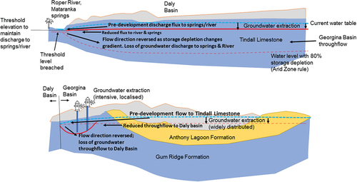
The Arid Zone rule’s two main components (no deleterious effect on GDEs and depletion of aquifer storage by up to 80% over 100 years) may appear to be distinct criteria; however, they are strongly inter-dependent. In systems receiving limited recharge, we argue that they are contradictory (Currell and Ndehedehe Citation2022). In settings where recharge is small relative to overall aquifer volume, extracting 80% of storage will inevitably result in the loss of groundwater flows to connected aquifer regions, surface water systems and GDEs. GDE health depends upon maintenance of aquifer water levels above thresholds which allow groundwater discharge to springs and baseflow to rivers, evapotranspiration by vegetation, and stygofauna habitat. Crucially, it also depends upon maintenance of flux rates to surface discharge points along the groundwater flow path. This is strongly related to the maintenance of aquifer water levels (i.e. storage depletion) though often in a non-linear way (Zipper et al. Citation2022).
As such, establishing the mechanisms, rates and importance of groundwater flows to the surface (e.g. river baseflow and spring flows), encompassing throughflows along regional flowpaths, and acceptable levels of impact to these is central to estimating the sustainable yield. Aside from discharge to the Roper River from the CLA (which has been quantified within reasonable levels of confidence), there has been limited quantification of discharge flows to the surface and establishment of associated threshold aquifer water levels required to sustain these, elsewhere in the CLA (see ).
Permitting the ‘mining’ of a substantial fraction of storage under the Arid Zone rules or allocating an Estimated Sustainable Yield without clear understanding of groundwater discharge rates and processes, risks harm to GDEs, through one or a combination of:
a) Groundwater levels at points of discharge (e.g., spring or riverbank) may reduce below a threshold elevation, which causes groundwater flows to the surface to cease
b) Groundwater flow gradients change in direction and/or magnitude, such that groundwater flux from the aquifer reduces or no longer flows in the direction of the GDE
c) Throughflow between different CLA basins – e.g., from the Georgina or Wiso Basin in the south into the Daly Basin in the north, may be reduced by changes to groundwater flow gradients, with potential flow-on effects on GDEs distant from the point of extraction. (including the iconic Mataranka springs and upper Roper and Flora rivers)
For two of the CLA basins (Daly and Georgina), these impacts are represented conceptually in :
3.3. No accounting for socio-cultural and conservation values and exclusion of local voices
Here, we turn our critique to the recently declared Georgina-Wiso WAP (Northern Territory Government Citation2023c). The Plan was drafted and declared without oversight from a stakeholder advisory committee, departing from standard practice in the NT, and expectations of the NWI. The WAP allocates a large volume (210 GL/year) to consumptive uses, which (if fully utilised) would be a 14-fold increase on current extraction rates. This has been done without considering the water requirements of places of importance to Indigenous people and of high conservation value. For these and other inadequacies, the Northern Land Council called on the NT government to withdraw the plan (Northern Land Council Citation2023); however, this appeal was ultimately ignored.
Some 13% of the land area regulated by the Plan are recognised as eligible Aboriginal land to which the Aboriginal Reserve (20,251 ML/p.a.) applies under the NT’s Strategic Aboriginal Water Reserve Policy (Northern Territory Government Citation2023c). The purpose of the Strategic Aboriginal Reserve is to secure access to water to Aboriginal landowners for economic benefit (O’Donnell et al. Citation2022). However, there is no evidence in the WAP and associated documents (Northern Territory Government Citation2023c,b,c) that in determining the ESY, consideration was given to the cultural and social aspects of the environment. Further studies are proposed in the Implementation Actions statement; however, key Indigenous cultural sites relying on water and their requirements will not be identified until sometime between 2026 and 2028 (and other social and cultural values not until 2028). The monitoring of Indigenous cultural values is scheduled to commence in 2027–2028 (Northern Territory Government Citation2023b).
No effort was made to ascertain the water requirements of any places or activities of cultural significance or specify what management actions would protect such places or uses. The Council of Australian Government’s Guidelines on Water Planning (2017) state that:
Quantifying the volume, flow and timing of water required to realise cultural outcomes is fundamental if Indigenous peoples’ needs for water are to be met through water planning and management processes. While there may be some alignment between cultural and environmental water needs, it is important to note that this is not always the case and there may be a need to differentiate cultural and environmental water requirements.
The establishment of an Aboriginal Reference Group is proposed in the Plan as a means of obtaining information on cultural values and uses, however if such a group is created it may occur after licences are granted. The failure to provide a mechanism through which Indigenous voices, values, knowledge, experience, and priorities are to be considered and incorporated in the water planning and decision-making process is inconsistent with clause 52(i) of the National Water Initiative (NWI), which states that planning processes should ensure ‘inclusion of indigenous representation in water planning wherever possible’.
No reason has been given by the government for why it was not possible to ensure meaningful engagement in this case, however the independent officer charged with overseeing the implementation of the recommendations of the NT’s fracking inquiry attributed the omission to ‘the imperative to meet the 31 December 2022 target’ in the government’s Pepper Inquiry Implementation Plan (Ritchie Citation2023). In advice to the NT Chief Minister in May 2023, Dr David Ritchie cautioned the government:
The fact that regional Water Advisory Committees have not yet been appointed for the areas where the onshore gas industry plans to expand their operations has reinforced the perception held by many Aboriginal people in affected communities that the traditional significance of groundwater has been ignored by government and industry. In the five years since the [Pepper] Inquiry’s Final Report, the inadequacy of meaningful engagement with Aboriginal people in remote communities about their traditional concerns has continued to draw both condemnation and calls for remedial action by governments.
Furthermore, sub-section (vi) of Clause 25 of the NWI states that parties should ‘identify and acknowledge surface and groundwater systems of high conservation value and manage these systems to protect and enhance those values’. The Plan includes a 20 ML/year allocation for environmental purposes (less than 0.01% of the volume allocated for consumptive use), yet the background report (Northern Territory Government Citation2023a) indicates that groundwater-dependent ecosystem mapping and ground-truthing are yet to be completed. The Plan contends that groundwater discharge to the surface by evapotranspiration does not occur (or is negligible) in the Georgina and Wiso basins, due to generally deep water tables. However, monitoring bore coverage remains sparse, and regions where groundwater is accessed by vegetation may simply remain poorly documented. There are (for example) springs in the western the Wiso Basin, whose vegetation appears likely to be sustained by CLA discharge, but whose water requirements and source aquifer have not been determined (Tickell Citation2022). Equating deep water tables to a lack of environmental dependence on groundwater also further down-plays the importance of regional flows within highly connected aquifer systems like the CLA. Any water extracted along a regionally connected flow path ultimately captures flows to the regional discharge point(s) – which may be outside the plan area (for example, the Roper and Flora Rivers, see ). Protecting the ecological value of stygofauna, which inhabit deep aquifer environments, and whose habitat would be lost if water levels decline substantially, has also not been considered as a significant objective of the plan.
4. Values at risk
CLA groundwater is vital to sustaining multiple values – Indigenous and non-Indigenous socio-cultural, ecological, and economic (see Jackson Citation2006; Jackson et al. Citation2008; Pusey Citation2008). Studies of these values have focussed mostly on the northern portion of the CLA (the Daly basin), where intensive water and catchment planning has been underway since the early 2000s. This work is briefly summarised below; readers are referred to the references cited for further detail. Far less is known about the groundwater-related values in Georgina and Wiso basins, which are currently the most prospective areas for shale gas and, potentially, the expansion of large-scale irrigation development.
4.1. Indigenous socio-cultural values
In this region as with the rest of inland Australia, the availability of water shaped the movement of Indigenous peoples, and complex cultural landscapes were constructed around spiritually powerful water bodies created by ancestral beings. Water sources of the CLA, particularly springs, contain higher concentrations of culturally significant landscape features, including places with personal, family or clan group associations (Jackson and Barber Citation2016). Underground waters are also significant and frequently feature in Indigenous ritual knowledge (Cooper and Jackson Citation2008). For example, the groundwater-fed baseflows of the Katherine and Flora Rivers provide permanent water sources that sustain ecologically rich ecosystems and are correspondingly rich in the occurrence of Indigenous cultural sites and patterns of occupation and use (Cooper and Jackson Citation2008).
There are several published studies of the social arrangements and cultural practices relating to water, including the Indigenous knowledge of groundwater and surface water sources, held by cultural groups in the vicinity of the Daly River and Katherine (see Jackson Citation2006; Jackson and Altman Citation2009; Cooper and Jackson Citation2008; Barber and Jackson, Citation2011; Citation2014; Citation2015) and Merlan (Citation1982). Cooper and Jackson (Citation2008) argue that the extent of Indigenous hydrological knowledge is evidenced by the richness of terms and concepts contained within local languages. Every aspect of water as a phenomenon and a physical resource, as well as the hydro-morphological features it creates, is represented, and expressed in the languages of local Indigenous cultures. For example, the Jawoyn language has a term for water which is carbonated or high in lime, maminga, and is regarded as ‘light water’.
Barber and Jackson (Citation2011, 23–24) interviewed traditional owners of the Roper region. The views documented help explain the central and fundamental importance of water:
‘Water is life, gives life to the land. It feeds the environment, keeps country cool and healthy. We don’t like to damage country. It’s good for fishing, swimming, camping. We use it for teaching too- cultural stories, bedtime stories, camping beside the river. Its our heritage. We need it to visit, enjoy life’. M.H.
‘There is a spring close to Beswick community. That water never dies, it will always be there. It gives us water to drink, and for the animals too’. J.M.
Key sites within the upper Roper catchment to which Aboriginal peoples attach cultural and/or spiritual significance include Red Lily Wetlands, Barlyurra (a complex of water sites upstream of Red Lily Lagoon), waterholes and permanent springs along the Roper River and large riparian trees, which depend on groundwater. Oral accounts from the east of the CLA towards Borroloola are consistent with other accounts of the integral role of groundwater in connecting Aboriginal peoples with their ancestors and other entities across vast distances (Ah Chee Citation2002; Marshall Citation2017):
‘The story of the Walalu, Stranger Rainbow Serpent is very important and very sacred … The Walalu is sometimes called Yankarra, which is Yanyuwa [language] for “the Stranger”, he is called this because he came from such a long way away and, once he moves through Garrwa and Yanyuwa country he keeps moving all the way into Marra country, he moves through Alawa and Mangarrayi country, and finishes his journey at the Mataranka hot springs which is far to the west’.
This knowledge of the inter-connectivity of groundwater over long distances is consistent with hydrogeological and hydrobiological lines of evidence (e.g. Oberprieler et al. Citation2021), which indicate extensive connectivity between the three basins hosting the CLA. It is thus of critical importance to consider impacts of groundwater usage in one region on others, as well as ensuring the custodians across regions share in making decisions affecting water flows.
Another example comes from the Katherine region where local Aboriginal people know that water is maintained in the Katherine River during the dry season because of the inflow of groundwater from springs. They attribute this inflow to the presence and actions of Rainbow Serpents:
‘The spring him fill up with water from the ground, so now him dry [dry season] … that river still runnin’ from that spring. Him bin that spring all the time. Important because that Rainbow Serpent they sit down there longa spring every time … When him dry you know that the spring gotta have him water because that Rainbol there’.
According to Cooper and Jackson (Citation2008), Wardaman knowledge also recognises the role of Rainbow Serpents in creating and maintaining groundwater and springs and provides an explanation of hydrogeological processes observed in western scientific studies. This includes an understanding of the connectivity and direction of flow through limestone strata, e.g. between underground water contained in the Tindall Aquifer and that which emerges at Mataranka and the Flora River (Bruwer and Tickell Citation2015).
Cultural practices relating to water have been detailed in these studies and court reports, including talking to country, ‘watering’ strangers and others in ‘baptism’ rituals, restrictions on behaviour and activities such as fishing, protecting others from harm and management and protection of sites. These practices are a consequence of belief in the continuing spiritual presence in the landscape of creation beings as well as more recent remembered and unremembered ancestors, or ‘old people’, returned to their countries as spirits (Cooper and Jackson Citation2008). A determining say in water governance and management is based on the responsibility of traditional owners and custodians to act appropriately within the network of relationships that constitutes Country.
We contend that it is highly likely that similar narratives, beliefs and values are associated with the water flows within and passing through the Georgina and Wiso basins, but the lack of effort to engage with traditional owners and understand these values – as part of water planning process, or western-science focussed research initiatives such as the SREBA, leaves no basis to understand and appropriately manage to protect such values and avoid or mitigate significant risk of harm to them. The Independent Officer overseeing implementation of the recommendations of the Pepper Inquiry concurs with this evaluation, concluding that even after the SREBA reports were released, risks to Aboriginal people and their culture, due to lack of meaningful engagement, remain at an ‘unacceptable level’ (Ritchie Citation2023, 13).
4.2. Other cultural, economic, and ecological values
Limited research has been conducted on the cultural groundwater values of the non-Indigenous community. Mataranka springs, encompassing iconic sites such as Bitter and Rainbow springs and Elsey National Park, are major tourism sites, with visitors contributing to the estimated $1.0 billion of direct and $1.2 indirect gross tourism value for the NT (Tourism Citation2020). There are also approximately 40 GL/year of current groundwater entitlements from the CLA in the Mataranka area – most for irrigated agriculture (Northern Territory Government Citation2017). Stock and domestic water use are estimated to be considerably lower, however these water supplies are critical for the pastoral industry which generates over $1 billion per year. Loss of access would make many stations unviable.
CLA groundwater also supports surface and sub-surface ecosystems that are both obligate (requiring permanent groundwater) and facultative, as defined in Doody et al., (Citation2019). The importance of groundwater in sustaining Mataranka Thermal Pools, Red Lily Lagoon, Flying Fox Creek, Mainoru River and Wilton River, and associated vegetation communities is relatively well documented (Knapton Citation2009). These vegetation communities are small in terms of land area but serve as critically important habitat for both local and migratory animals (Short Citation2020; Woinarski et al. Citation2000). Fish and flow dependencies have also been established in the Daly sub-basin (Pusey et al. Citation2020).
Stygofauna are also widespread in the CLA. These were surveyed in the Beetaloo sub-basin and Roper River catchment, after being identified as a knowledge gap in the Pepper Inquiry (Oberprieler et al. Citation2021; Rees et al. Citation2020). The surveys identified a diverse range of species, dominated by crustaceans, including the blind shrimp Parisia unguis. The occurrence of the same species across the Georgina, Wiso and Daly basins is evidence of high connectivity throughout the CLA system, underscoring the importance of coordinated management that recognises the importance of cross-basin flows and potential impacts to these.
4.3. Key threats to groundwater dependent values of the CLA
We consider the values described above to be at risk under the existing and emerging approach to the NT’s groundwater regulation. This is primarily due to the risk of reducing flows to surface and sub-surface GDEs, through both capture and groundwater level reduction (see section 3), interference with existing water supplies, and other poorly understood risks. These include potential compaction of the aquifer matrix (less common in limestone aquifers than unconsolidated sediments, but nonetheless possible – Laroque et al. Citation1998), and contamination of freshwater through migration of saline water bodies (Currell and Ndehedehe Citation2022).
Ecohydrological and modelling studies have yet to determine threshold groundwater elevations required to sustain springs and groundwater-dependent streams and vegetation above the CLA, nor have they determined in detail the extent of reduction in baseflows and water levels (and associated environmental impacts) that may occur at different extraction rates in different regions. Previous numerical modelling has examined the effects of groundwater extraction at different rates on baseflow to the Roper River – e.g. Bruwer and Tickell (Citation2015) modelled extraction of 20% of estimated recharge to the Tindall Limestone from a wellfield near Larrimah and found this would reduce baseflow by ~20% in the long term. More recently, numerical modelling of the CLA system (based on the model reported in Knapton Citation2020) has been used as one line of evidence to develop the ESY for the Georgina-Wiso WAP. These modelling results (included in the Georgina Wiso Background Report 2023–2031) report ‘imperceptible’ impacts on river flows from simulated extraction at different rates under historic (to 1970) climate conditions. However, clear documentation of input assumptions and model uncertainty and sensitivity analysis for the reported extraction scenarios are not published, and specific water level gradient, flux, and ecological effects of extraction at the proposed ESY remain undocumented (see Northern Territory Government Citation2023c & c).
The impacts of future drought periods and/or climatic change, which may result in fundamental shifts in aquifer system water balance and behaviour (as demonstrated during the Millennium Drought and subsequent lack of recovery of several catchments in Australia’s Murray Darling Basin – Peterson et al. Citation2021) must also be considered. Mechanisms to adjust management rules in line with the CLA system’s response(s) to climate change must be incorporated into WAPs, in line with the intent of the NWI (Walker et al. Citation2021).
Given that there are, a) significant Indigenous socio-cultural, ecological and water use values associated with the CLA’s groundwater documented in the Daly basin and b) a lack of documentation of the nature and extent of these values in the Georgina and Wiso basins – where there is significant development pressure, and c) substantial risk of harm associated with the current groundwater regulatory regime (sections 3 & 4), we urge a precautionary approach to further development and implementation of WAPs, and other groundwater governance measures.
5. Towards sustainable co-management of groundwater
Efforts to reform water management in the NT warrant action on several fronts, including law reform, improvements to the collective knowledge base, wider transparency, public engagement and sharing of decision-making power with Aboriginal custodians. Some of these issues are identified in the recently published Northern Territory Water Plan (e.g. the intention to create Advisory Councils for strategic water advice and enhancing Aboriginal participation in water management). However, the plan does not delve into water allocation planning processes and the role of water advisory committees in developing WAPs or offer substantive models for sharing decision-making power with Aboriginal people (Northern Territory Government Citation2023d). Here, we make some key suggestions for a path forward, based on the issues identified in sections 3 and 4:
5.1. A robust and transparent approach to determining sustainable yields
The Arid Zone rule appears to be one of the only cases in Australia where a fraction of total storage is a basis for determining ‘sustainable’ extraction rates. Reliance on such measures should (in our view) be phased out in line with increasing understanding of the connections and values sustained by groundwater. Instead, more explicit focus should be given to ensuring ‘no deleterious change in groundwater discharges to dependent ecosystems’ – noting that knowledge of these dependencies needs significant further research in the NT. In the long term, a more effective way to manage the CLA’s groundwater, which would align with contemporary best practice, would involve setting extraction rate limits which ensure:
groundwater flows and levels do not decline in ways that compromise the health of key groundwater-dependent ecosystems (springs, wetlands, stygofauna, and phreatophyte vegetation). This requires a careful analysis of recharge and discharge fluxes, environmental dependencies on these, and the extent of ‘capture’ by pumping at different rates in different areas. Connectivity of the CLA with rivers and throughflow across sub-basins (e.g. Georgina and Wiso basins to Daly basin) must be thoroughly understood, and extraction rate limits set within a given management area must be sustainable cumulatively, in conjunction with those set in adjacent WAP areas.
the renewability of groundwater resources, preventing ongoing storage depletion and/or detrimental capture of surface flows, e.g. by not exceeding any significant fraction of the recharge and/or discharge. In the Murray Darling Basin (for example), Sustainable Diversion Limits (SDLs) are set based on the rate of diffuse groundwater recharge, and modelling/analysis of the impacts of extracting different fractions of recharge on baseflow to streams, GDEs, water quality and aquifer integrity. In areas where such risks are deemed high, SDLs can be set as low as 5% of recharge; in other ‘low risk’ areas, the fraction may be as high as 70%, although this is rare (Walker et al. Citation2020).
The ESY set for the 2023–31 Georgina Wiso WAP equates to approximately one-third of the estimated annual recharge – though it is not specifically stated that the value was determined on this basis. While extraction at this rate is likely to be more protective of ecological and cultural values than allowing 80% depletion of storage over 100 years, the highly variable, episodic nature of recharge in this arid region means that:
the ESY will far exceed recharge in most years, leading to some degree of storage depletion and (through reduced throughflows), capture of water flowing to ecosystems
the recurrence interval for episodic recharge events – which are the dominant source of aquifer replenishment, are currently unknown and may vary with climate change. For example, significant recharge may not occur at all during the term of the plan, and the above (a) effects, accumulated over multiple years, may result in environmental damage.
Further, the estimated average recharge rates cited in the Plan are not underpinned by extensive observational data and should be considered uncertain (Currell and Ndehedehe Citation2022). Given evidence of strong connectivity throughout the CLA (Oberprieler et al. Citation2021; Tickell Citation2022), management within and between declared groundwater allocation plan areas must be carefully coordinated, such that flows between sub-basins and regions (which may cross WAP boundaries) are factored into sustainable yield estimations and ongoing monitoring. Managing by aquifer system boundary, rather than sub-regions that do not align with hydro(geo)logical boundaries, would help to facilitate more coordinated sustainable management.
5.2. Readily monitored and enforceable trigger levels and robust adaptive management
In addition to robust determination of ESYs, protection of GDEs further requires clearly defined water level triggers and/or thresholds, e.g. groundwater elevations required to sustain environmental and cultural values of key groundwater-dependent sites and ecosystems (Noorduijn et al. Citation2019). Under such arrangements, when threshold levels are approached or crossed, reductions in groundwater pumping would be triggered, in line with management approaches adopted in other parts of Australia and internationally (Thomann et al. Citation2020). Pitfalls associated with the application of such trigger levels in isolation must be considered – for example, triggers must be set at an appropriate distance from the environmental asset(s) seeking to be protected, to account for time-lags between changes in extraction rates, hydraulic gradients, and flow rates in an aquifer. Triggers based on drawdown at the location of a GDE, set without a clear understanding of water flux (as well as level) requirements, remain potentially risky (Currell Citation2016). Further, there is a need for such management protocols to account for and be responsive to Indigenous knowledge and risk evaluations along with detailed eco-hydrological studies (e.g. Doody, Hancock, and Pritchard Citation2019). Regular observations and monitored data relating to ecosystem health should inform ongoing, iterative adjustment of management triggers, in line with stakeholder-agreed objectives (Thomann et al. Citation2020). Acknowledging these issues, the use of triggers designed to protect GDEs in conjunction with extraction rate limits holds potential to strengthen management via robust and defensible criteria that can be actively monitored.
5.3. Collaborative governance of water
Sustainable and equitable groundwater co-management must address the inherent rights of Indigenous peoples to make decisions regarding the waters flowing within and through their sovereign territories (Marshall Citation2017; O’Donnell et al. Citation2022). Statements in recent media reports and published studies (e.g. Jackson and Altman Citation2009; Jackson et al. Citation2008; Nikolakis and Grafton Citation2022) affirm that traditional owners of the CLA region expect that they have a legitimate basis in terms of recognised rights and interests, for assuming a position of at least negotiating parity with non-Indigenous decision-makers and landowners. Such a claim for parity could be expressed in institutions of ‘co-management’, or sharing of power and responsibility between government and local communities, including in water sharing arrangements. A report by Hoverman et al. (Citation2012), undertaken in partnership with the NT water department, found that there was substantial opportunity for the development of co-management approaches in the NT.
Models of decision-making and rights recognition that fall under the rubric of co-management could form the basis for discussions about wider catchment management and protections of connected surface and groundwaters in the Beetaloo region. In the lower Murray and lakes region of South Australia, for example, co-management partnerships take the form of contractual agreements with water agencies; they are a means of gaining control over Ngarrindjeri jurisdiction (Hemming et al. Citation2019). In the Kimberley, heritage listing recognises the Martuwarra (Fitzroy) River as a living, or ancestral, being and there are calls from the Indigenous Martuwarra Council for recognition of pre-existing and continuing legal authority of Indigenous law and more substantive legal protections (RiverOflife et al. Citation2021). Aotearoa/New Zealand has progressed co-management of freshwaters (Taylor et al. Citation2021) for example, legislation arising from a treaty settlement explicitly recognises that the Waikato River is a tupuna (ancestor) and established the Waikato River Authority composed of Maori and Pakeha representation (Te Aho Citation2010). More recently, a new Conservation Order for the Te Waikoropupū freshwater springs was enacted, following collaboration between iwi Ngāti Tama ki Te Waipounamu Trust, and local conservationists, who filed a joint legal action (Ministry for the Environment New Zealand Citation2023). In Canada, First Nations are challenging state assertions of control over traditional territories and weak consultation and assessment processes that ignore cumulative or broader catchment impacts. Curran (Citation2019) explains that Canadian First Nations are establishing administrative and governance structures that express their water laws and jurisdiction. Many of the examples involve the formation of new catchment scale Indigenous bodies and advocates, to assert the right of free and prior informed consent over water licencing.
Such approaches should extend to the production of ‘two-ways’ hydrological knowledge. Scientific practices of estimating yield and principles of sustainability need to respond to the wealth of Indigenous knowledge of groundwater systems in the Northern Territory. This would also include developing the means to measure and monitor success and act on Indigenous principles and ethics of ‘caring for country’. As water management is fundamentally a governance challenge, the priority for reform is to establish a dialogue and build the capacity to negotiate collaborative partnerships, founded on consent, customary law, and plurality of knowledge and values.
Acknowledgements
Matthew Currell and Christopher Ndehedehe received funding in 2022 and 2023 from the Environment Centre, NT, which supported their research into many of the issues discussed in this paper. We are grateful to two anonymous reviewers who provided constructive comments that helped improve the manuscript.
Disclosure statement
No potential conflict of interest was reported by the author(s).
Additional information
Funding
Notes on contributors
Matthew Currell
Matthew Currell is a professor at Griffith University, with a background in hydrogeology, environmental tracer science and groundwater policy.
Sue Jackson
Sue Jackson is a professor at Griffith University who researches the social dimensions of natural resource management, including the interaction between Indigenous customary and state environmental governance and planning systems, as well as the meaning of water, its symbolic significance and material value.
Christopher Ndehedehe
Christopher Ndehedehe is a Senior Lecturer at Griffith University and expert in satellite hydrology and environmental geo-informatics.
Notes
1. Rural and Regional Affairs and Transport References Committee Senate transcript 18/11/2003: https://parlinfo.aph.gov.au/parlInfo/search/display/display.w3p;query=Id:committees/commsen/7147/0004
2. The statements were made in 2022 in response to community opposition to an application to extract groundwater (1,200 ML p.a.) to mine sand near Larrimah (Fitzgerald Citation2022) and in a meeting of the Mataranka Tindall Water Advisory Committee, 12 August 2021 (https://depws.nt.gov.au/__data/assets/pdf_file/0008/1049453/mataranka-tindall-wac-meeting-11-minutes-and-appendices.pdf)
References
- Ah Chee, D. 2002. “Kwatye, Indigenous peoples connection with kwatye (water) in the Great Artesian Basin.” Environment SA 9 (1): 20–25. https://globalwellnessinstitute.org/wp-content/uploads/2018/12/2014-Indigenous-People-Connection-with-Kwatye-Dean-Ah-Chee.pdf.
- Alley W. M., T. E. Reilly and O. L. Franke. 1999. Sustainability of Ground Water Resources. Denver CO: USGS Circular.
- Barber, M., and S. Jackson. 2011. Indigenous Water Values and Water Planning in the Upper Roper River, Northern Territory. CSIRO: Water for a Healthy Country National Research Flagship.
- Barber, M., and S. Jackson. 2012. Indigenous Water Management in the Upper Roper River, Northern Territory: History and Implications for Contemporary Water Planning. Darwin: CSIRO.
- Barber, M., and S. Jackson. 2014. “Autonomy and the Intercultural: Interpreting the History of Australian Aboriginal Water Management in the Roper River Catchment, Northern Territory.” Journal of the Royal Anthropological Institute 20 (4): 670–693. https://doi.org/10.1111/1467-9655.12129.
- Barber, M., and S. Jackson. 2015. “Remembering ‘The blackfellows’ Dam’: Australian Aboriginal Water Management and Settler Colonial Riparian Law in the Upper Roper River, Northern Territory.” Settler Colonial Studies 5 (4): 282–301. https://doi.org/10.1080/2201473X.2014.1000903.
- Bardon, J., 2022, September 30. “NT Government Warned by Its Own Advisor Against Water Allocation Changes, Impacts on Roper River.” ABC News Online. https://www.abc.net.au/news/2022-09-27/mining-water-rules-changed-nt-government-industry-beetaloo/101476414.
- Bierkens, M., and Y. Wada. 2019. “Non-renewable groundwater use and groundwater depletion: a review.” Environmental Research Letters 14 (6): 063002. https://doi.org/10.1088/1748-9326/ab1a5f.
- Bruwer, Q., and S. J. Tickell, 2015. “Daly Basin Groundwater Resource Assessment – North Mataranka to Daly Waters, Department of Land Resource Management.” Water Resources Report Number 20/2915D.
- Cooper, D., and S. Jackson, 2008. Preliminary study on Indigenous water values and interests in the Katherine region of the Northern Territory, [ Unpublished report to the North Australian land & Sea Management Alliance’s Indigenous Water Policy Group].
- Crosbie, R. S., and P. K. Rachakonda. 2021. “Constrição probabilística do balanço de massa de cloreto na estimativa da recarga usando fluxo de base e evapotranspiração obtida por sensoriamento remoto: o Aquífero Calcário Cambriano no norte da Austrália.” Hydrogeology Journal 29 (4): 1399–1419. https://doi.org/10.1007/s10040-021-02323-1.
- Curran. 2019. “Indigenous Processes of Consent: Repoliticizing Water Governance Through Legal Pluralism.” Water 11 (3): 571. https://doi.org/10.3390/w11030571.
- Currell, M. J. 2016. “Drawdown “Triggers”: A Misguided Strategy for Protecting Groundwater-Fed Streams and Springs.” Groundwater 54 (5): 619–622. https://doi.org/10.1111/gwat.12425.
- Currell, M. J., and C. Ndehedehe, 2022. “The Cambrian Limestone Aquifer, Northern Territory: Review of the Hydrogeology and Management Rules to Ensure Protection of Groundwater Dependent Values.” Report prepared for Environment Centre NT. https://www.researchgate.net/publication/366029788_The_Cambrian_Limestone_Aquifer_Northern_Territory_Review_of_the_Hydrogeology_and_Management_Rules_to_Ensure_Protection_of_Groundwater_Dependent_Values.
- Currell, M. J., and C. Ndehedehe, 2023. SREBA Expert Review – Groundwater. Report Commissioned by the Environment Centre, NT: https://assets.nationbuilder.com/ecnt/pages/914/attachments/original/1697102379/SREBA_Review_Currell_and_Ndehedehe_August_2023.pdf?1697102379.
- DEPWS (Department of Environment, Parks and Water Security), 2022. “Regional Report: Strategic Regional Environmental and Baseline Assessment for the Beetaloo Sub-Basin. DEPWS Technical Report 41/2022. Department of Environment, Parks and Water Security, Northern Territory Government.” Berrimah, Northern Territory.
- Deslandes, A., C. Gerber, S. Lamontagne, C. Wilske, and A. Suckow. 2019. Environmental Tracers in the Beetaloo Basin. Aquifer and Groundwater Characterization. Australia: CSIRO.
- Doody, T. M., P. J. Hancock, and J. L. Pritchard, 2019. “Information Guidelines Explanatory Note: Assessing Groundwater-Dependent Ecosystems. Report Prepared for the Independent Expert Scientific Committee on Coal Seam Gas and Large Coal Mining Development Through the Department of the Environment and Energy.” Commonwealth of Australia 2019
- Evans, T. J., B. M. Radke, J. Martinez, S. Buchanan, S. B. Cook, M. Raiber, T. R. Ransley. 2020. “Hydrogeology of the Beetaloo GBA Region. Technical Appendix for the Geological and Bioregional Assessment: Stage 2. Department of the Environment and Energy, Bureau of Meteorology, CSIRO and Geoscience.” Australia.
- Fitzgerald, D., 2022, September 22. “Plans to Mine Northern Territory Sand for Fracking in the Beetaloo Basin.” ABC News Online. https://www.abc.net.au/news/rural/2022-09-01/territory-sands-plan-to-mine-for-beetaloo-fracking-nt/101386946.
- Fitzgerald, R., 2022 October 22. “Pastoralists, Traditional Owners, Environmental Groups, Call for Moratorium on NT Water Licenses.” ABC News Online. https://www.abc.net.au/news/2022-10-15/traditional-owners-pastoralists-water-moratorium-nt-government/101539976.
- Frery, E., C. Byrne, R. Crosbie, A. Deslandes, T. Evans, C. Gerber, C. Huddlestone-Holmes, et al. 2022. “Fault-Related Fluid Flow Implications for Unconventional Hydrocarbon Development, Beetaloo Sub-Basin (Northern Territory, Australia).” Geosciences 12 (1): 37. https://doi.org/10.3390/geosciences12010037.
- Gautam, D., L. Nunn, D. Irvine, and C. Duvert, 2022. Beetaloo Sub-Basin SREBA Water Studies: Application of Remote Sensing Techniques for Estimating the Evapotranspiration Flux from Spring Systems. Report Prepared for the Northern Territory Department of Environment, Parks and Water Security by the Research Institute for the Environment and Livelihoods, Charles Darwin University.
- Hemming, S., D. Rigney, S. Bignall, S. Berg, and G. Rigney. 2019. “Indigenous Nation Building for Environmental Futures: Murrundi Flows Through Ngarrindjeri Country.” Australasian Journal of Environmental Management 26 (3): 216–235. https://doi.org/10.1080/14486563.2019.1651227.
- Higgins, P. A., J. G. Palmer, M. P. Rao, P. S. Andersen, C. S. M. Turney, and F. Johnson. 2022. “Unprecedented High Northern Australian Streamflow Linked to an Intensification of the Indo-Australian Monsoon.” Water Resources Research 58 (3): e2021WR030881. https://doi.org/10.1029/2021WR030881.
- Hoverman, S., K. Delfau, and P. Tan 2012. “Developing Alternative Management Models for Indigenous Water Plans and Strategies in Australia’s North, Final Report NAWFA Social and Cultural Project, Sub-Project, 3.” Griffith University
- Jackson, S. 2006. “Compartmentalising Culture: The Articulation and Consideration of Indigenous Values in Water Resource Management.” Australian Geographer 37 (1): 19–32. https://doi.org/10.1080/00049180500511947.
- Jackson, S., and J. Altman. 2009. “Indigenous Rights and Water Policy: Perspectives from Tropical Northern Australia.” Australian Indigenous Law Review 13 (1): 27–48.
- Jackson, S., and M. Barber. 2016. “Historical and Contemporary Waterscapes of North Australia – Indigenous Attitudes to Dams and Water Diversions.” Water History 8 (4): 385–404. https://doi.org/10.1007/s12685-016-0168-8.
- Jackson, S., E. O’Donnell, L. Godden and M. Langton In Press . In press. “Ontological Collisions in the Northern Territory’s Aboriginal Water Rights Policy, Oceania.”
- Jackson, S., N. Stoeckl, A. Straton, and O. Stanley. 2008. “The Changing Value of Australian Tropical Rivers.” Geographical Research 46 (3): 275–290. https://doi.org/10.1111/j.1745-5871.2008.00523.x.
- Jonscher, S. 2022. “Minister’s Decision to Re-Grant a Water License on Singleton Station Was ‘Rational’, Court Told.” ABC News Online, September 10. https://www.abc.net.au/news/2022-09-10/nt-court-singleton-station-water-licence-hears-economic-case/101419418.
- Karp, D., 2008. “Surface and Groundwater Interaction the Mataranka Area. Department of Natural Resources, Environment, the Arts and Sport.” Report No. 17/2008D.
- Knapton, A. 2009. “Gulf Water Study. Integrated Surface – Groundwater Model of the Roper River Catchment. Part A: Coupled Surface – Groundwater Model. Department of Natural Resources, Environment.” The Arts & Sport, Technical Report 15/2009D.
- Knapton, A., 2020. “Upgrade of the Coupled Model of the Cambrian Limestone Aquifer and Roper River Systems.” WRD Technical Report 57/2020.
- Lamontagne, S., A. Suckow, C. Gerber, A. Deslandes, C. Wilske, and S. Tickell. 2021. “Groundwater Sources for the Mataranka Springs (Northern Territory, Australia).” Scientific Reports 11 (1): 24288. https://doi.org/10.1038/s41598-021-03701-1.
- Langton, M. 2002. Freshwater, in Background Briefing Papers: Indigenous Rights to Waters, 43–64. Broome: Lingiari Foundation.
- Laroque, M., A. Mangin, M. Razack, and O. Banton. 1998. “Contribution of Correlation and Spectral Analyses to the Regional Study of a Large Karst Aquifer (Charente, France).” Canadian Journal of Fisheries and Aquatic Sciences 205 (3–4): 217–231. https://doi.org/10.1016/S0022-1694(97)00155-8.
- Lee, C. H. 1915. “The Determination of Safe Yield of Underground Reservoirs of the Closed-Basin Type.” Transactions, American Society of Civil Engineers LXXVIII (1315): 148–218. https://doi.org/10.1061/TACEAT.0002653.
- Marshall, V. 2017. Overturning Aqua Nullius: Securing Aboriginal Water Rights. Canberra, ACT: Aboriginal Studies Press.
- Merlan, F. 1982. “A Mangarrayi Representational System: Environment and Cultural Symbolisation in Northern Australia.” American Ethnologist 9 (1): 145–166. https://doi.org/10.1525/ae.1982.9.1.02a00090.
- Ministry for the Environment New Zealand, 2023 October 12. “Press Release: “Waikoropupu Springs Water Conservation order”.” https://environment.govt.nz/acts-and-regulations/water-conservation-orders/waikoropupu-springs-water-conservation-order/.
- Nikolakis, W., and R. W. Grafton. 2022. “Law versus Justice: The Strategic Aboriginal Water Reserve in the Northern Territory, Australia.” International Journal of Water Resources Development 38 (1): 11–29. https://doi.org/10.1080/07900627.2021.1882406.
- Noorduijn, S. L., P. G. Cook, C. T. Simmons, and S. B. Richardson. 2019. “Protegendo os níveis de água subterrânea e ecossistemas com simples abordagens de gestão.” Hydrogeology Journal 27 (1): 225–237. https://doi.org/10.1007/s10040-018-1849-4.
- Northern Land Council, 2023. “Submission to the Northern Territory Government on Draft Georgina Wiso Water Allocation Plan 2022-2030, Draft Georgina Wiso Background Report 2022-2030, Draft Georgina Wiso 2022-2030 Implementation Actions.” https://www.nlc.org.au/uploads/pdfs/20221612-NLC-Submission-Georgina-Wiso-WAP.pdf.
- Northern Territory Government, 2000. “Northern Territory Water Allocation Planning Framework (Policy).” https://depws.nt.gov.au/__data/assets/pdf_file/0011/476669/nt-water-allocation-planning-framework.pdf.
- Northern Territory Government, 2017 June. “Background Brief: Water Allocation Plan for the Tindall Limestone Aquifer, Mataranka – Daly Waters.” Prepared by Department of Environment and Natural Resources. https://denr.nt.gov.au/__data/assets/pdf_file/0005/438008/Background-Brief-Tindall-Limestone-Aquifer-Mataranka-to-Daly-Waters.pdf. and noble gases (qualitative insights)
- Northern Territory Government. 2020. “SREBA Framework: A Guide to Undertaking a Strategic Regional Environmental and Baseline Assessment in the Northern Territory.” Department of the Chief Minister and Department of Environment and Natural. Resources. https://depws.nt.gov.au/__data/assets/pdf_file/0005/914297/sreba-framework.pdf.
- Northern Territory Government, 2021. SREBA Water Quality and Quantity Studies (Project 1) Water Resources Division Report Number 18/2021v
- Northern Territory Government, 2023a. Georgina Wiso Background Report 2023 – 2030. Report 13/2023. Department of Environment, Parks and Water Security: Northern Territory, Australia.
- Northern Territory Government. 2023b. Georgina Wiso Implementation Actions 2023 – 2030. Northern Territory, Australia: Department of Environment, Parks and Water Security.
- Northern Territory Government. 2023c. Georgina Wiso Water Allocation Plan 2023 – 2030. Department of Environment, Parks and Water. Security: Northern Territory.
- Northern Territory Government. 2023d. Territory Water Plan: A Plan to Deliver Water Security for All Territorians, Now and into the Future. NT Office of Water Security. https://watersecurity.nt.gov.au/__data/assets/pdf_file/0003/1247520/territory-water-plan.pdf.
- Northern Territory of Australia. 1992. “Water Act 1992, As in force at 1 August”. https://legislation.nt.gov.au/en/Legislation/WATER-ACT-1992.
- Oberprieler, S., G. Rees, D. Nielsen, M. Shackleton, G. Watson, L. Chandler, and J. Davis. 2021. “Connectivity, Not Short-Range Endemism, Characterizes the Groundwater Biota of a Northern Australian Karst System.” Science of the Total Environment 796:148955. https://doi.org/10.1016/j.scitotenv.2021.148955.
- O’Donnell, E., S. Jackson, M. Langton, and L. Godden. 2022. “Racialized Water Governance: The ‘Hydrological frontier’ in the Northern Territory, Australia.” Australasian Journal of Water Resources 26 (1): 59–71. https://doi.org/10.1080/13241583.2022.2049053.
- Peterson, T. J., M. Saft, M. C. Peel, and A. John. 2021. “Watersheds May Not Recover from Drought.” Science 372 (6543): 745–749. https://doi.org/10.1126/science.abd5085.
- Ponce, V. 2007. Sustainable Yield of Groundwater. California Department of Water Resources. http://gwsustainability.sdsu.edu.
- Pusey, B., Ed. 2008. Aquatic Biodiversity in Northern Australia: Patterns, Threats and Future. Darwin: Charles Darwin University Press.
- Pusey, B., M. Douglas, J. Olden, S. Jackson, Q. Allsop, and M. Kennard. 2020. “Connectivity, Habitat, and Flow Regime Influence Fish Assemblage Structure: Implications for Environmental Water Management in a Perennial River of the Wet–Dry Tropics of Northern Australia.” Aquatic Conservation 30 (7): 1–20. https://doi.org/10.1002/aqc.3347.
- Rees, G. N., S. Oberprieler, D. Nielsen, G. Watson, M. Shackleton, and J. A. Davis. 2020. Characterisation of the Stygofauna and Microbial Assemblages of the Beetaloo Sub-Basin, Northern Territory. Australia: CSIRO.
- Ritchie, D., 2023. “Re: Progress on the Implementation of Recommendations from the Final Report of the Hydraulic Fracturing Inquiry – Final Considerations 2023”. https://hydraulicfracturing.nt.gov.au/__data/assets/pdf_file/0016/1221181/dr-ritchies-final-letter-may2023.pdf.
- RiverOfLife, Martuwarra, A. Pelizzon, A. Poelina, A. Akhtar-Khavari, C. Clark, S. Laborde, E. Macpherson, K. O’Bryan, E. O’Donnell, and J. Page. 2021. “Yoongoorrookoo, The emergence of ancestral personhood.” Griffith Law Review 30 (3): 505–529. https://doi.org/10.1080/10383441.2021.1996882.
- Scientific Inquiry into Hydraulic Fracturing in the Northern Territory, 2018. “Final Report of the Scientific Inquiry into Hydraulic Fracturing in the Northern Territory.” March 27, 2018. https://frackinginquiry.nt.gov.au/inquiry-reports/final-report.
- Short, M. A., 2020. Mapping Potential Groundwater Dependent Ecosystems Using Landsat Imagery: Mataranka Tindall Limestone Aquifer. Technical Report 53/2020. Department of Environment, Parks and Water Security (Water Resources Division), NT Government.
- Short, M. A., and T. W. Bond, 2021. Classification of Top End and Arid Zone for Northern Territory Water Resources, Technical Report 55/2020. Water Resources Division, Northern Territory Department of Environment, Parks and Water Security, Northern Territory Government. Palmerston, Northern Territory.
- T, Amery., 2022. Beetaloo Sub-Basin SREBA Water Studies: Aquifer Test Data Review for the Primary Overlying Aquifers. Technical Report 21/2022. Department of Environment, Parks and Water Security. Palmerston, Northern Territory.
- Taylor, L. B., A. Fenemor, R. Mihinui, T. A. Sayers, T. Porou, D. Hikuroa, N. Harcourt, P. White, and M. O’Connor. 2021. “Ngā Puna Aroha: Towards an Indigenous-Centred Freshwater Allocation Framework for Aotearoa New Zealand.” Australasian Journal of Water Resources 25 (1): 27–39. https://doi.org/10.1080/13241583.2020.1792632.
- Tchakerian, V., and P. Pease. 2015. “The Critical Zone in Desert Environments.” In Developments in Earth Surface Processes 19, edited by J.R. Giardino and C. Houser, 449–472. Amsterdam: Elsevier.
- Te Aho, L. 2010. “Indigenous Challenges to Enhance Freshwater Governance and Management in New Zealand—The Waikato River Settlement.” The Journal of Water Law 20:285–292.
- Theis, C. V. 1940. “The Source of Water Derived from Wells: Essential Factors Controlling the Response of an Aquifer to Development.” Civil Engineering 10 (5, May): 277–280.
- Thomann, J. A., A. D. Werner, D. J. Irvine, and M. J. Currell. 2020. “Adaptive Management in Groundwater Management: A Review of Theory and Application.” Canadian Journal of Fisheries and Aquatic Sciences 586:124871. https://doi.org/10.1016/j.jhydrol.2020.124871.
- Tickell, S. 2022. Beetaloo Sub-Basin SREBA Water Studies: Aquifer Mapping and Summary Report. Technical Report 19/2022. Northern Territory Department of Environment, Parks and Water Security. Palmerston, Northern Territory.
- Tickell, S. J., and Q. Bruwer, 2017. Georgina Basin Groundwater Assessment: Daly Waters to Tennant Creek, Technical Report 17/2017 (Version 2, April 2019), Northern Territory Department of Environment and Natural Resources. Northern Territory Government, Australia.
- Todd, D. K. 1959. Ground Water Hydrology. New York: John Wiley and Sons.
- Tourism, N. T., 2020. Nt’s Tourism Industry Strategy 2030. https://www.tourismnt.com.au/system/files/uploads/files/2020/nt-tourism-industry-strategy-2030-summary-report.pdf.
- Walker, G., S. Barnett, S. Richardson 2020. “Developing a Coordinated Groundwater Management Plan for the Interstate Murray-Darling Basin.” In Sustainable Groundwater Management: A Comparative Analysis of French and Australian Policies and Implications to Other Countries. Global Issues in Water Policy 24, edited by J.-D. Rinaudo, 143–161. Switzerland AG: Springer Nature.
- Walker, G. R., R. S. Crosbie, F. H. S. Chiew, L. Peeters, and R. Evans. 2021. “Groundwater Impacts and Management Under a Drying Climate in Southern Australia.” Water 13 (24): 3588. https://doi.org/10.3390/w13243588.
- Water Resources Review Panel, 2021. Re: Controller’s Decision to Grant Groundwater Extraction Licence TLAM10002, Darwin, Northern Territory: Water Resources Review Panel. 17 May 2021.
- Woinarski, J. C. Z., C. Brock, M. Armstrong, C. Hempel, D. Cheal, and K. Brennan. 2000. “Bird Distribution in Riparian Vegetation in the Extensive Natural Landscape of Australia’s Tropical Savanna: A Broad-Scale Survey and Analysis of a Distributional Data Base.” Journal of Biogeography 27 (4): 843–868. https://doi.org/10.1046/j.1365-2699.2000.00439.x.
- Zipper, S. C., W. H. Farmer, A. Brookfield, H. Ajami, H. W. Reeves, C. Wardropper, J. C. Hammond, T. Gleeson, and J. M. Deines. 2022. “Quantifying Streamflow Depletion from Groundwater Pumping: A Practical Review of Past and Emerging Approaches for Water Management.” JAWRA Journal of the American Water Resources Association 58 (2): 289–312. https://doi.org/10.1111/1752-1688.12998.