
 ?Mathematical formulae have been encoded as MathML and are displayed in this HTML version using MathJax in order to improve their display. Uncheck the box to turn MathJax off. This feature requires Javascript. Click on a formula to zoom.
Abstract
The viceroyal ecclesiastical architecture of the Puno region in Peru is the legacy of the evangelisation in the western part of Lake Titicaca. In recent years, the preservation of this heritage has been threatened by various risks including planar deformation and cracking. The objective of the study presented here is to determine the level of threat in terms of risk and to understand the pathologic agents that affect the conservation of these important facades. The methodology used focussed on non-destructive techniques, including visual inspection, digital image processing and thermography, to identify the processes affecting the facades. Multidisciplinary analysis using geographic information systems facilitated the mapping of naturally-induced risks, while multidimensional evaluation using qualitative techniques, such as consultation with experts and surveys, helped determine the level of anthropic risk. The results generally demonstrate a low to medium level of risk to the facades but suggest a higher incidence of pathologies of a physical origin. Results of the study help establish what are the critical threats to the conservation of built heritage in the Andes region and represent a contribution to conservation management by demonstrating the use of non-destructive techniques for damage assessment.
Résumé
« Menaces sur la préservation des façades de l’église vice-royale de Juli, Pérou »
L'architecture ecclésiastique vice-royale de la région de Puno au Pérou est l'héritage de l'évangélisation dans la partie occidentale du lac Titicaca. Ces dernières années, la préservation de ce patrimoine a été menacée par divers risques notamment la déformation plane et la fissuration. L'objet de l'étude présentée ici est de déterminer le niveau de menace en termes de risque et de comprendre les agents pathologiques qui affectent la conservation de ces façades importantes. La méthodologie utilisée s'est concentrée sur des techniques non destructives, notamment l'inspection visuelle, le traitement d'images numériques et la thermographie, pour identifier les processus affectant les façades. L'analyse multidisciplinaire utilisant les systèmes d'information géographique a facilité la cartographie des risques d'origine naturelle, tandis que l'évaluation multidimensionnelle utilisant des techniques qualitatives, telles que la consultation d'experts et les enquêtes, a contribué à déterminer le niveau de risque anthropique. Les résultats démontrent généralement un niveau de risque faible à moyen pour les façades mais suggèrent une incidence plus élevée d’altérations d'origine physique. Les résultats de l'étude aident à établir quelles sont les menaces critiques pour la conservation du patrimoine bâti dans la région des Andes et représentent une contribution à la gestion de sa conservation en démontrant l'utilisation de techniques non destructives pour l'évaluation des dommages.
Zusammenfassung
„Gefahren für die Erhaltung der vizeköniglichen Kirchenfassaden von Juli, Peru“
Die kirchliche Architektur der Vizekönigreiche in der Region Puno in Peru ist das Erbe der Missionierung im westlichen Teil des Titicacasees. In den letzten Jahren war die Erhaltung dieses Erbes durch verschiedene Risiken wie flächige Verformung und Rissbildung bedroht. Ziel der hier vorgestellten Studie ist es, den Grad der Bedrohung zu bestimmen und die pathologischen Faktoren zu verstehen, die die Erhaltung dieser wichtigen Fassaden beeinträchtigen. Die angewandte Methodik konzentrierte sich auf zerstörungsfreie Techniken, einschließlich visueller Inspektion, digitaler Bildverarbeitung und Thermografie, um die Prozesse zu identifizieren, die die Fassaden beeinträchtigen. Die multidisziplinäre Analyse mit Hilfe von geografischen Informationssystemen erleichterte die Kartierung der natürlich bedingten Risiken, während die multidimensionale Bewertung mit Hilfe qualitativer Techniken wie der Befragung von Experten und Umfragen dazu beitrug, den Grad des anthropogenen Risikos zu bestimmen. Die Ergebnisse zeigen im Allgemeinen ein geringes bis mittleres Risiko für die Fassaden, deuten aber auf eine höhere Inzidenz von Pathologien physikalischen Ursprungs hin. Die Ergebnisse der Studie tragen dazu bei, die kritischen Bedrohungen für die Erhaltung des baulichen Erbes in der Andenregion zu ermitteln, und stellen einen Beitrag zum Erhaltungsmanagement dar, indem sie die Anwendung zerstörungsfreier Techniken zur Schadensbewertung demonstrieren.
Resumen
“Amenazas a la preservación de las fachadas de las iglesias virreinales de Juli, Perú”
La arquitectura eclesiástica virreinal de la región de Puno, Perú es el legado de la evangelización en la parte occidental del lago Titicaca. En los últimos años, la preservación de este patrimonio se ha visto amenazada por varios riesgos, como la deformación en la morfología del suelo y el agrietamiento. El objetivo del estudio presentado es determinar el nivel de amenaza en términos de riesgo y comprender los agentes patológicos que afectan a la conservación de estas importantes fachadas. La metodología utilizada se centró en técnicas no destructivas, incluidas la inspección visual, el procesamiento de imágenes digitales y la termografía para identificar los procesos que afectan a las fachadas. El análisis multidisciplinario utilizando sistemas de información geográfica facilitó el mapeo de los riesgos naturales, mientras que la evaluación multidimensional utilizando técnicas cualitativas, como la consulta con expertos y las encuestas, ayudó a determinar el nivel de riesgo antrópico. Los resultados generales demuestran un nivel bajo a medio de riesgo para las fachadas, pero sugieren una mayor incidencia de patologías de origen físico. Los resultados del estudio ayudan a establecer cuáles son las amenazas críticas a la conservación del patrimonio construido en la región de los Andes y representan una contribución a la gestión de la conservación al demostrar el uso de técnicas no destructivas para la evaluación de daños.
摘要
“关于秘鲁朱利总督府教堂外观保护所面临的威胁”
秘鲁普诺地区的总督教堂建筑是的的喀喀湖(Lake Titicaca)西部传播福音的遗产。近年来,这一遗产保护受到了各种风险的威胁,包括平面变形和开裂。本研究的目的是确定风险威胁程度,并了解影响保护这些重要外观的病理因素。研究侧重于非破坏性技术的方法来确认影响外观的过程,包括视觉检查、数字图像处理和热成像。通过地理信息系统进行多学科分析有助于绘制自然引起的风险图,而使用定性技术(如咨询专家和调查)进行的多维评估 则有助于判断人为风险的程度。研究结果表明,外观所面临的风险总体处于中低水平,但由物理原因引起的病变发生率较高。该研究结果有助于确定安第斯地区建筑遗产保护所面临的主要威胁,并通过示范评估损伤的非破坏性技术,为遗产保护管理做出贡献
Introduction
Architectural heritage continues to be exposed to a range of threats that contribute to the potential for its loss. During the nineteenth century, the recognition of the importance of cultural and architectural heritage motivated the implementation of various measures for its protection, preservation, maintenance and restoration. The degradation of architectural heritage is caused by various factors, including environmental and geomorphological forces, as well as anthropic causes such as neglect by the relevant authorities, the lack of documentation including planning and acts of vandalism.Footnote1 Gaining an understanding of both the risks and pathologies of decay that threaten heritage buildings has led to the development of protocols and methodologies for their preservation.Footnote2 These approaches were consolidated in the twentieth century with the promulgation of various international charters, beginning with the Athens Charter in 1931Footnote3 and the Venice Charter in 1964Footnote4 and, more recently, the Krakow Charter (2000)Footnote5 has updated what is considered the most important criteria for architectural conservation and restoration.
Fundamental to all this work is that preventive measures must be taken into consideration as part of any methodology designed to identify, evaluate and control the threats that affect built heritage. Furthermore, threat evaluation needs to incorporate appropriate measures to reduce any negative effects revealed and this must be taken into consideration as part of any methodology designed to identify, evaluate and control the threats that affect built heritage.Footnote6
Currently, the methods used to assess the condition of a building are classified under three types: destructive, semi-destructive and non-destructive.Footnote7 Non-destructive testing (NDT), the focus of this article, includes a range of activities such as visual inspection,Footnote8 digital image processing (DIP)Footnote9 and thermography. Visual inspection allows for the recognition of the building’s state of conservation,Footnote10 and when combined with DIP, provides significant information on areas of damage that allow for the detailed characterisation and mapping of the various pathologies present.Footnote11 Additionally, given that temperature variations are involved in every physical process, the use of thermography allows for further classification of the material state of conservation without the use of invasive methods. Measuring radiant thermal energy distributions can serve to detect the pathologies of decay as they develop according to exposure to various temperatures; for example, colder zones can show delamination due to the action of humidity as a result of rain, while warmer spots can promote biological growth.Footnote12
A comprehensive analysis of pathological processes implies, in the first place, the identification and understanding of both internal pathogenic agents (those intrinsic to the material) and external pathogenic agents (those defined by external agents) that cause visible deterioration or macroscopic indicators of alteration (damage).Footnote13 It is of utmost importance to know the typology of any deformation as the starting point of any pathological study, and the choice of appropriate conservation and maintenance depends on its correct identification.Footnote14 It should also be noted that some damage can be the result of structural and functional changes to the building, which can modify the loads and resistance of its structural elements.Footnote15
External risks to heritage can be human or natural in origin, and both have different effects, some of which can cause considerable damage whose results may be immediately visible. Others accumulate more slowly and remain invisible for a long time.Footnote16 In order to understand the risks and natural threats, it is necessary to carry out a study of a building’s wider environment and this involves understanding the regional geology, precipitation rates, temperature and humidity, and geomorphology, as well as being able to access archives of past episodes and disasters.Footnote17 In a multidisciplinary study, the implementation of spatial analysis using geographical information systems (GIS) is useful to determine and map the location and level of impact of external threats and current condition of a heritage site, thereby helping to extend the useful life of the selected buildings.Footnote18
In contrast, the use of qualitative techniques such as cultural heritage evaluation surveys can assist to determine any anthropic hazards, whether direct or indirect. Anthropic hazards can be low frequency, but have a cumulative impact and are often the result of ignorance about the heritage itself and the values it embodies.Footnote19 In preventive conservation an important strategy is to perform a holistic analysis of a building while avoiding the use of invasive and expensive techniques.
In recent decades the Peruvian government through the Ministry of Culture has implemented new policies that offer a legal framework for the protection of both tangible and intangible heritage.Footnote20 The interest in the preservation of the built heritage of Peru has led to the recognition of multiple buildings as being historical monuments because of their patrimonial and architectural value.Footnote21 As a result, churches in the Altiplano region were declared national heritage and significant restoration works were carried out in 1978.Footnote22 However, despite this interest there are still deficiencies in the legal frameworks for their preservation given that, amongst other things, there is no protocol for the periodical evaluation of these buildings in order to determine both risk and the need for their repair and maintenance. In addition, the methods currently used, such as digital reports using images and drawings of damaged areas, are not always effective over a long-term period and, furthermore, not every international regulation can be applied to the heritage buildings of Peru owing to its different geography and climate. This, combined with the generally outdated information on heritage buildings, has led to slow and often incomplete or inadequate restoration of the ecclesiastical architecture focussed on in this article.
In Peru viceroyal churches and regional schools were developed early because the Viceroyalty of Castile was one of the oldest and most important cultural political centres in South America.Footnote23 The churches are an example of the artistic and architectural scope represented by the indigenous colonies provided in Andean towns.Footnote24 Likewise, the importance of these buildings lies in the fact that they assume, within a town, a symbolic value.Footnote25 Cusco, Arequipa and Altiplano were the main regional architectural schools in the viceroyalty period and these based the architectural conception of their churches around social, cultural, geographical and climate factors, which conferred both meaning and a local identity to the particular building.Footnote26 At the end of seventeenth century, architecture was increasingly developed in schools of regional architecture and in the towns of the Altiplano these sought to maintain their own architectural language by implementing techniques, materials and elements related to nature and the Andean tradition. The use of earthen (adobe and quincha) and stone as construction materials in this viceroyal period continued as they were essential to the inherited construction techniques used,Footnote27 and three stylistic phases characterise these methods.
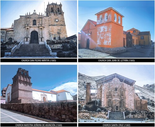
The first phase showed a predominance of the Renaissance style; the second is characterised by the viceroyal baroque style used in the central towns of Altiplano, and finally, in the third phase, planiform-style architecture was promoted in the western districts, such as in Juli, Pomata and Zepita.Footnote28 The city of Juli was connected to the trade routes of Lima, Cusco and Potosí,Footnote29 and was important enough to have four viceroyal churches: ‘San Pedro Mártir’, ‘San Juan de Letrán’, ‘Nuestra Señora de Asunción’ and ‘Santa Cruz’ ().Footnote30 The viceroyal churches of Juli were also declared as nationally important cultural heritage by the Ministry of Culture and are part of the tourist route in Puno.Footnote31 The churches have been damaged over the years by different external factors, both natural and anthropic, and these factors also resulted in the loss of a fifth church, ‘Santa Bárbara’, which was representative of the Aymara people.Footnote32
Fig. 1 Viceroyal churches in Juli, Perú.
Only two of the churches have records about their state of conservation and the records that do exist are not well detailed and have not been updated, and this state of affairs has inhibited any programme of periodic maintenance, with the last intervention being carried out in 2008.Footnote33 Because there has not been any comprehensive conservation study of the facades of Juli’s viceroyal churches the authors decided to set about trying to answer the question of what are the risks that currently affect their state of conservation?
Objectives
The aim of the research is to define the risks that affect the state of conservation of the facades of the selected churches through the analysis of damage pathologies and the mapping of external risk factors based on field studies, documentation and data analysis using graphic and statistical software. The churches of Juli have a socio-cultural importance as a place for the development of local traditions and cultural manifestations of the highland community,Footnote34 and studying the risks and pathologies of the buildings defines the preventive actions needed to mitigate any extant damage and structural deformation to help guarantee the continuity of these buildings.Footnote35 Such an investigation needs to take account of how the enhancement of a heritage building not only requires the historical knowledge of the building, its architectural characteristics and the materials used, but also an understanding of its current state of conservation. This means the preparation of a technical dossier for its preservation is imperative.Footnote36 As such, the study described here will hopefully be an important source of information about ecclesiastical architecture in Andean towns as well as presenting a methodology that can be used in any future investigation into the historical monuments in the region.
Materials and methods
Given the characteristics of the churches and the need for a complete and rigorous diagnosis, the research design had a qualitative approach that used data from the extant documentation, direct observation and field surveys. This provided input for the evaluation of a chosen building and allowed the identification of possible damage or alteration, along with determining those external factors that have resulted in degradation. The approach is non-experimental and cross-sectional in character in that it analyses existing risks and any visible physical damage that has occurred, but without manipulating the materials or structure used with regard to the original architectural conception nor building techniques.
The methodology is organised in three phases: data collection; data analysis; and the interpretation of results ().
Fig. 2 Flow chart of the methodology phases in the study.
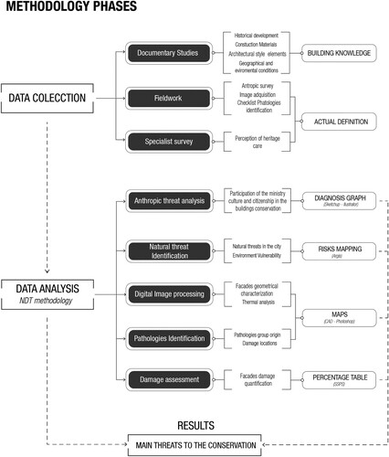
1 Data collection
In the data collection phase, a documentary study was carried out based on bibliographic and archival information related to the historical development, maintenance work and planning, allowing for the identification of the architecture of the facades in their original state. Subsequently a multidisciplinary approach allowed the collection of data on precipitation, geomorphology, geo-referencing and environmental conditions.Footnote37
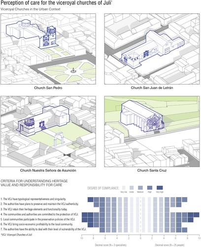
An NDT (non-destructive testing) methodology was implemented and visual inspection was performed during the field work. This was complemented by the development of a checklist for the identification of any pathological agents affecting a building by means of a five step workflow that described any damage or alteration to the different elements of the facade through: identification, location of damage, description of the type and origin of the damage or alteration, its evaluation and any further observations.Footnote38 The image acquisition and evaluation through the use of scaffolding through ‘digital image processing’ (using Photoshop and AutoCad) allowed for the recompilation of images of the facades and the identification and detailed geometrical characterisation of the detected damage affecting them.Footnote39 This phase was concluded with a multidimensional evaluation using a 21-question qualitative survey for the evaluation of cultural heritage established by the University of Valencia,Footnote40 and used with experts from the architectural heritage and cultural heritage offices of the Peruvian Ministry of Culture to interrogated their perceptions of built heritage in the region in order to determine their understanding about its intrinsic value for society, its vulnerability and the current state of its conservation. Subsequently, these results were compared with the results shown from a 5-question survey applied to 20 residents of Juli to determine the public perception and appreciation for the churches facades.
2 Data analysis
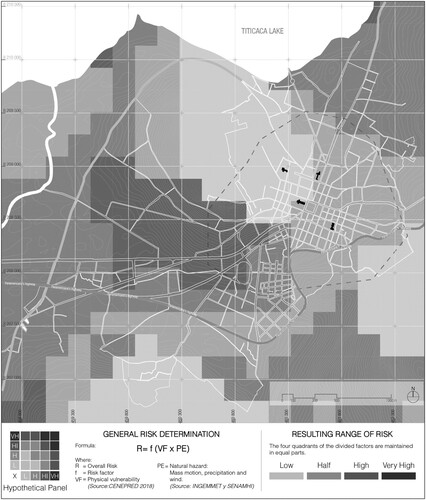
In the data analysis phase, the data obtained from the documentation, the field work and the surveys were systematically evaluated. With the support of IBM’s SPSS Statistics software the results of the survey on knowledge of the risks related to the abandonment of cultural property and the lack of documentation were analysed. Furthermore, the spatial analysis capabilities of geographical information systems (GIS) software (ArcGIS) were used for the cartographic representation of the level of risk affecting each study site. This analysis was augmented using macro-zoning and micro-zoning to use both geophysical and climate data collected from three national institutions: the National Center for Disaster Risk Estimation, Prevention and Reduction (CENEPRED); the Geological, Mining and Metallurgical Institute (INGEMMET); and the National Meteorological and Hydrological Service of Peru (SENAMHI).Footnote41
3 Interpretation of results
From the collected data a risk map was to be produced based on the interpolation of the climate and physical hazards and considering the amount of impact on the churches established by the national institutions. The analysis of the facades was to be interpreted on the basis of the damage types as proposed in an article by Spanish researchers on the preventive conservation of medieval earthen fortifications in the south of Spain.Footnote42 For the specific determination of the damage found, the mapping was to be performed using the images collected in the first phase and extant pathologies were classified according to their origin: environmental action, biological action, human action and chemical action. Through the comparison of the architectural and stylistic characteristics of the facades and the use of thermography using infrared and luminance filters, the most affected areas of the facades were identified, allowing for the development of the degradation map. In order to help determine the scale and number of damage types their percentage was tabulated for each facade.
Finally, the interpretation of these results allowed for a definition of the level of risk and the main pathologies that affect the current state of conservation of the church facades.
Results
1 Study sites
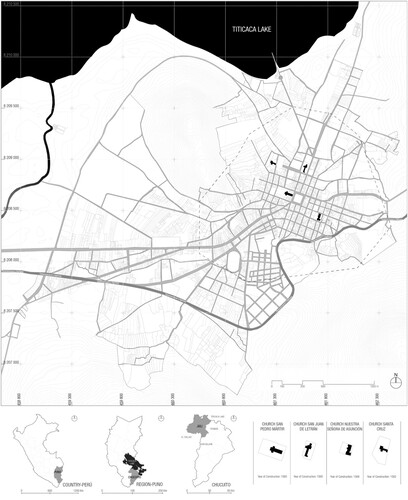
The viceroyal churches are located in the city of Juli, capital of the province of Chucuito, in the south of the Puno region ().Footnote43 Juli presents a slightly uneven territory with slight slopes and an orthogonal urban area centred around the main square which is surrounded by political and religious institutions.Footnote44 The city is located in the western area of Lake Titicaca, which acts as a thermo-regulator in reducing extreme temperatures and generating a semi-dry climate most of the year.Footnote45 Juli is considered to have tourist potential at an international level as it is part of the historic trade route of Cusco, Puno and La Paz, and it has pre-Hispanic archaeological remains as well as colonial architecture and beautiful natural landscapes.Footnote46
Fig. 3 Location map of the province of Juli in Chucuito with the location of the viceroyal churches. Source: Municipalidad de Juli, 2016.
2 Identification of the architectural styles of the facades
The churches were initially developed under the influence of the Renaissance style carried out in the sixteenth century, using local earthen construction techniques. The ‘San Juan de Letran’ Church was begun in 1565 by the Dominicans and completed by the Jesuit order. The main facade is in the Renaissance style of the Altiplano Regional School and consists of a semi-flat form with a central opening, a gabled roof and a tower with two windows in the steeple. The facade is flanked by pilasters that end in pinnacles and that support a triangular pediment. Volumetric contrasts are generated by the use of staggered mouldings on the architrave; the cornice protrudes at the level of the imposts and capitals, and the jambs have recessed panels and support the semicircular arch of the doorway. In contrast, the Church ‘Nuestra Señora de Asunción’ was finished in 1698 by the Jesuit order. The main facade has a geometric unity with a central square bay and a gabled roof of Renaissance proportions. The facade has two pilasters with flat bases and capitals that support a frieze with the remains of a pediment and two jambs that support the semicircular arch of the access. The now collapsed stone bell tower has mouldings to its base, cornices, and in the upper part, four columns with double capitals. There are also decorated planiform corbels which accentuate the chiaroscuro effect to emphasise the baroque styling of the facade. The facades of the two other churches, ‘San Pedro Mártir’ and ‘Santa Cruz’, also share features of the Renaissance style of the time and are simple and clear in their form ().
Fig. 4 Photographic set-up for the recognition of style elements in the analysed facades, drawings using CAD.
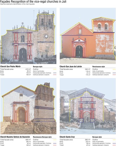
The arrival of the Jesuits led to the use of the baroque style on the facades in the seventeenth and eighteenth centuries. The oldest, ‘San Pedro Mártir’, was remodelled in symmetrical facade, has sets of paired columns with flat bases and is divided horizontally with cornicing. In the central part there is a door with a lintel supporting a semicircular arch and in the second course body there is a planiform ornamentation that surrounds the only opening in the facade. On the left side is a bell tower that has three sections divided by cornices and is capped with a dome. The bell tower has two openings influenced by the Cuzco school and is flanked by columns with planiform style ornamentation. Another of the churches, ‘Santa Cruz de Jerusalén’, was built in 1582 by the Jesuits. This church combines two typologies of construction, having the earthen material in the main body and local stone for the tower. The main facade is composed of curves representative of the baroque language of the Regional School (Puno-Altiplano). The symmetrical facade is an altarpiece decorated with bunches of grapes, monkeys, hummingbirds, and other regional flora and fauna. It has three courses framed by Solomonic columns in high relief that ascend in a descending number to form the semblance of a pyramid. The three courses are divided by entablatures and a semicircular pediment. The central course has a delimited access with a semicircular arch and a venerate niche with an oculus above it in the form of a semicircular arch. The lateral towers have collapsed and stone walls remain in their place. The viceroyal churches ‘San Pedro Mártir’ and ‘Santa Cruz de Jerusalén’ are defined by a greater interpretation of the baroque style of the Regional School of the Altiplano.
Extrinsic threats analysis
1 Main anthropic threats
In the survey of specialists, the variable of anthropic threats was scored unfavourably, mainly due to the omissions made by the authorities in charge of the sites. These included incomplete technical and maintenance documentation and records which makes any conservation plans for the churches more difficult. Furthermore, the survey of the local population highlighted how they were unaware of necessary works because of a lack of communication with the authorities which also meant they were not made aware of how they could contribute to the maintenance of the churches ().
Fig. 5 Church location in context. Overview of the results obtained through the application of the anthropic risk and value perception of the viceroyal churches survey.
2 Main natural threats
2a Climate threat
The assessment of natural hazards determined that climate, specifically rainfall and wind direction, were important factors that present risk to the material of the buildings. The SENAMHI climate classification map showed that the churches of Juli are located in a semi-dry, cold climate environment, which is very common in areas near Lake Titicaca. The facades are exposed to an annual rainfall of 300mm and a relative humidity of 65%, which causes erosion and seepage in the adobe walls, and dirt stains on the paintwork of the ‘San Juan’ and ‘Asunción’ churches. Moreover, it encourages the appearance of biocolonisation on the stonework at the churches ‘San Pedro’ and ‘Santa Cruz’. The predominant wind direction from the southwest is consistent with the orientation of the main facades of the four churches, but the adobe buildings are more affected than the stone ones, since the strong air currents cause cracks in the coating. The region’s climate has a greater impact on the buildings due to the direct contact with the material and elements of the churches’ facades.
2b Physical threats
Physical factors such as mass ground movement and soil composition are natural risks present due to the city’s urbanisation over an irregular topology. INGEMMENT’s ground movement mapping shows that the churches are located in low- and medium-level hazard zones with characteristic undulations with slopes of 10–25%; such movement represents a geological settlement hazard that could cause structural deformation and cracking in the stone and adobe walls. Dissimilarly, a physical vulnerability map of the city prepared by CENEPRED shows that the churches are situated in both medium- and high-vulnerability terrain on account of the presence of variegated sandy limestone and calcareous limestone in the soil. Both can affect structural performance due to possible groundwater seepage that impacts the foundations of the churches. These physical factors therefore affect the structural aspect of the buildings to a greater extent than any anthropic threat and present a high incidence on the adobe and stone load-bearing walls, including the foundations of the adobe walls.
3 Mapping the risks from the results
A risk map made of Juli showed that the viceroyal churches are located in low- and medium-risk areas, based on taking into account their vulnerability as well as climatic and physical threats. The risk indicator was based on the combination of natural hazards with their vulnerability value following the formula:
Creating the risk map involved the multiplication of values: low, medium, high and very high, which were embedded in the ArcGIS software (). The resulting risk map visualised the incidence of environmental hazards in the selected churches and demonstrated how the exposure and self-degradation of the facade increased the risk of damage and altered its current state. This suggests that the anomalies identified in the facades may evolve in relation to the level of risk of the factors detected.
Fig. 6 Risk determination map through the intersection between natural threats and physical vulnerability.
4 Pathologic analysis
4a Major pathologies and their origins
The systematised pathology analysis showed that the most common forms of damage to the buildings studied are of an environmental and physical origin. These are followed by damage of a mechanical origin that affects the structure, damages of biological origin, damage related to human activity and finally chemical damage ().
Fig. 7 Detailed damage map and damage identification.
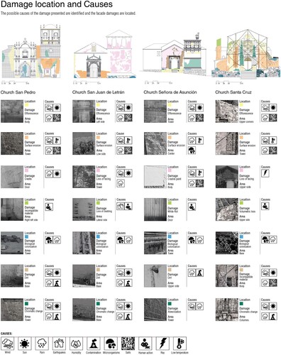
The atmospheric agents that mostly affect the churches are wind, rain, humidity and solar radiation with each variously affecting the materials and even causing structural damage in some cases. The deterioration in the materials as observed include erosion, soiling, detachment of coatings, delamination and damp. The biological damage originates from the activities of organic agents that generate the growth of vegetation, moss and fungi which, amongst other things, cause chromatic change. Human activity included the introduction of foreign materials, while chemical actions included chromatic change and efflorescence. Each church presented combinations of these types of damage with greater or lesser frequency, and the mapping also differentiates between superficial and structural damage.
4b Pathology analysis: ‘San Pedro Mártir’ Church
The Church of San Pedro Mártir presents superficial damage on the main facade due to exposure to the environment. The facade is composed of white granite and shows some erosion to the tower as well as chromatic change caused by salt efflorescence on the returns of the facade caused by the rain, hail, low temperatures and wind. Rain on the lower area of the main facade has generated an accumulation of soiling, biocolonisation, distortion of the material and discolouring of the wooden door. Previous restorations have shown that maintenance around the door included the use of materials such as plaster and concrete for repointing. The church has a rainwater collection gutter and a satellite antenna to the back of the tower and is surrounded by decorative vegetation in the form of a small square that is very well preserved. The church is the best preserved of those surveyed as it is strategically located in the centre of the city.
4c Pathology analysis: ‘San Juan de Letrán’ Church
Conservation needs for the San Juan de Letrán Church were perceived as superficial as it presents minor damage across all its facades. It is built in adobe and stone with four visible facades of which the most damaged are on the east and south. The main decay types are caused by environmental factors and include peeling paint, failed coatings, soiling and efflorescence on the buttresses. One stone facade to the south showed alveolar decay (honeycombing), erosion, chromatic change due to UV exposure, and efflorescence on the pedestals of the Ionic columns and in the niches. The frequent impact of rain, wind and solar radiation on the lower area of the facade walls generated an accumulation of dirt, detachment of coatings and biocolonisation between the stone joints. The structure has lost its geometry due to the detachment of stone arches, parts of which are still visible, as well as its adobe walls. The surroundings of the church present a slope full of vegetation that allows rainwater to dwell, thereby favouring biocolonisation. In spite of the previous restoration and maintenance works, ongoing damage is evident.
4d Pathology analysis: ‘Nuestra Señora de Asunción’ Church
The Nuestra Señora de Asunción Church was previously subject to an incomplete restoration evidenced by the damage to the facade. Fabric materials show multiple stains due to humidity, peeling paint and failed coatings as a result of the weathering; the erosion of the adobe is also noticeable and caused by exposure to atmospheric agents. This is especially apparent around the portal, reaching the tower. The wood of the doors presents white rot and chromatic alteration due to humidity from both rain and fungal attack. The stone tower shows efflorescence, slight alveolisation throughout and biocolonisation at the base. The structure on top of the stone tower is broken on three elevations and has not been completely restored. Moisture in the foundations has generated a slight differential movement that threatens the structure of the church. The church was the second most structurally affected church due to the loss of part of the tower.
4e Pathology analysis: ‘Santa Cruz de Jerusalén’ Church
The Santa Cruz de Jerusalén Church is the most affected of the churches in Juli, showing serious material damage and partial ruin of the structure. The mixed construction system of quincha, stone and adobe had been left abandoned such that the presence of humidity, strong winds and the impact of a lightning strike almost destroyed the church, leaving it without part of the roof and destroying the tops of its walls. The impact from heavy rain and humidity have generated erosion and deformation of the material in the main facade, as well as the development of vegetation between the joints of the stones. Staining, coating failure and efflorescence in the exposed stone altarpiece, especially in the paired columns, have affected the carving leading to a decrease in detail. Unfinished restoration works show the use of foreign material such as a calamine mineral roof and the wooden timbers that support it. The stone plinth to the church shows abundant biocolonisation between the joints. Previous restorations have maintained the originality of the decorated facade, and today it is still under restoration.
4f Pathology percentages
The percentages of damage to the facades of each church have been tabulated to demonstrate the areas of damage according to their origin, to help quantify each according to their risk level (). The percentage of damage was calculated from the total area of the facade divided by the area affected. The condition most present was efflorescence, representing 27.88% of damage to the facades of the four churches; the second most common condition was erosion with a total of 23.53%, mainly on the adobe facades. In contrast, the loss of roofing was 0.93% and was only in the Santa Cruz Church; similarly cracking showed 0.95% and was present in the ‘San Pedro’ and ‘Santa Cruz’ churches.
Table 1 Quantification of the main damage pathologies affecting the selected viceroyal church facades.
4g Threats to the conservation of the selected facades
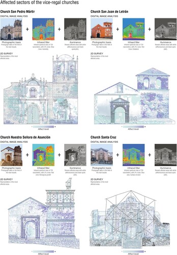
Each facade was sectored to help pinpoint the most affected areas according to the amount of damage. Digital analysis of images taken in the field was performed with the images being passed through a thermal infrared filter to reveal their temperature spectrum. Illuminance levels were then used to generate black and white images contrasted to determine the most affected areas of the facades. The surveys of the facades also highlighted the level of damage present in each sector with analysis showing that the churches made of stone suffered greater damage to their bases and towers than to the facades. The adobe churches, on the other hand, showed greater damage to their facades and towers due to previous paint coatings. In addition, high-level damage was detected to the portals and towers of the churches of ‘San Pedro’, ‘Asunción’ and ‘Santa Cruz’, while lower-level damage was distributed in the main part of the facades of ‘San Juan’ and ‘San Pedro’. This quantification of each facade helps show where prompt intervention is required ().
Fig. 8 Infrared and luminance filtering of the church facades for thermal analysis and degradation mapping.
Discussion
The research has addressed the analysis of the damage and external risks that affect the state of conservation of the viceroyal churches of Juli. Risk was assumed to have two aspects: anthropic and natural risks. The methodology used demonstrates how environmental factors have affected the state of conservation of the church facades, with damage mainly to the finishes due to rainfall, exposure to the sun and wind flow. Likewise, geological factors present a medium–low risk level for the conservation of these structures due to the steep slopes of Juli and the composition of the soil on which they are built.
In the case of anthropic risk, pre-existing maps made by those responsible for the conservation of the churches were consulted and combined with information from Juli’s inhabitants about any prevention measures taken by those in charge. This resulted in designating a medium risk due to the lack of action by authorities and obsolete documentation.
Finally, while all four churches present superficial damage, two of them, ‘Santa Cruz de Jerusalén’ and ‘Nuestra Señora de Asunción’, present structural damage; however, the ‘Santa Cruz de Jerusalén’ Church is the one that presents the greater damage, both at a structural and superficial level, due to the greater incidence of natural and anthropic risks.
Limitations
In developing the NDT methodology presented here, photographic techniques were used that only allowed for partial capture of the facades due to their scale; this means that the stitching together of images could result in temperature variations being recorded. This was hopefully counteracted by obtaining information about the facades by using multiple shoots of the various sectors to provide greater detail and clarity. These were then processed using Photoshop by applying an infrared filter configured according to ranges of 50–720nm and a Luminance Filter of 1.25” to increase the contrast. To verify the quality of information, the multiple shots were joined and the resulting photographic information was interpolated with a complete 2D survey of the facades which represents the different affected areas found. This process was fundamental for the accuracy of the results and determined the most affected sectors of the facades.
Recommendations
The research used a methodology adapted from a protocol for the study of heritage buildings that can be applied to achieve a rigorous evaluation of the risks to other types of ecclesiastical buildings, such as parish churches and monastic buildings. It is necessary for an analysis of different categories of risks specific to the place of study as is presented in this work; in addition, new categories can be configured according to each new study, given the potential for very different environmental, territorial and urban factors. Using an approach such as this, threat analysis can be carried out using machine learning-based technologies that allow for a more detailed scanning of damage. On the other hand, and in the light of this work, the public can update information on the state of conservation of the churches of Juli, to aid in planning an informed conservation strategy with which policy makers should then implement better heritage management. This is in addition to helping those institutions responsible for the care of these properties to better target where specialist conservation and restoration works are necessary.
Conclusions
The development of the research has highlighted the main natural and anthropic risks that endanger the preservation of the viceroyal churches of Juli. The most notable natural risks are climatic and geological. The climatic risks are due to the abundant presence of rain in the summer and spring months, the semi-dry climate and the incidence of winds; while the geological risks are due to the steep topography and the composition of the soil where the churches are located. The main anthropic risks faced by these churches are the lack of documentation and the lack of conservation planning by the responsible authorities. The main types and causes of damage are divided into four categories: physical-mechanical, biological, human and chemical, with the physical-mechanical category the most prevalent. Damage of a physical origin is mainly caused by environmental factors such as wind, solar radiation, humidity and rain, while damage of a mechanical origin is caused by the stress imparted to structural elements. The most common damage to the facades is efflorescence caused by the interaction between the salts of the material and humidity which represents 27.88%, and erosion caused by moisture ingress and egress at 23.53%.
While the singular characteristics of the facades are still preserved, the deterioration they have suffered due to the lack of adequate maintenance is notable. The external risks to the buildings are not recent problems, but their prolonged exposure is the cause of the increase in damage to elements of the facades. By estimating the risks and pathologies to the facades of the churches, it would be possible to establish preventive conservation plans for these buildings, thus avoiding the high costs of restoration a posteriori. This method of analysis therefore is offered to support better risk-based management by those institutions currently responsible for heritage protection in Peru.
Acknowledgements
The authors thank the architect Leonardo Pecchi from the Ministry of Culture for his collaboration in the anthropic risk surveys and the architect Cristian Yarasca for his contribution to the research methodology.
Additional information
Notes on contributors
Abigail Saldaña Cabanillas
Abigail Saldaña Cabanillas graduated from the Professional School of Architecture of the Universidad Peruana Unión. She has completed various courses in 3D modelling and has worked in construction and interior design. Her research work focusses on the historical development and preventive conservation of Peruvian heritage and she often presents at the Latin American Congress of Research in Architecture. Currently she is working for the construction and social programme, Llamkasun Perú.
Melanie Lupaca Huarac
Melanie Lupaca Huarac graduated from the Professional School of Architecture of the Universidad Peruana Unión. She is certified by CENEPRED for disaster risk management and has worked in construction and interior design. She is currently a supervising architect in the private company FD Architects in Lima and her research work focusses on construction systems and in the field of heritage. She has presented at various symposia including at the Universidad Peruana Unión.
Notes
1 Cf. for example, Giovanni Ruggiero, Rossella Marmo, and Maurizio Nicolella, ‘A Methodological Approach for Assessing the Safety of Historic Buildings’ Façades’, Sustainability 13, no. 5 (2021): 2812, https://www.mdpi.com/2071-1050/13/5/2812 (accessed 10 December 2023).
2 Eduardo Diz-Mellado et al., ‘Non-Destructive Testing and Finite Element Method Integrated Procedure for Heritage Diagnosis: The Seville Cathedral Case Study’, Journal of Building Engineering 37 (2021): 102134, https://doi.org/10.1016/j.jobe.2020.102134 (accessed 10 December 2023).
3 The Athens Charter for the Restoration of Historic Monuments, First International Congress of Architects and Technicians of Historic Monuments, Athens, 1931, https://www.icomos.org/en/167-the-athens-charter-for-the-restoration-of-historic-monuments (accessed 10 December 2023).
4 The Venice Charter: International Charter for the Conservation and Restoration of Monuments and Sites, https://www.icomos.org/images/DOCUMENTS/Charters/venice_e.pdf (accessed 10 December 2023).
5 ‘The Charter of Krakow: Principles for Conservation and Restoration of Built Heritage’, https://icomosubih.ba/pdf/medjunarodni_dokumenti/2000%20Krakovska%20povelja.pdf (accessed 10 December 2023).
6 Cf. for example, Koenraad Van Balen, ‘Preventive Conservation of Historic Buildings’, CHANGES (Changes in Cultural Heritage Activities: New Goals and Benefits for Economy and Society), 2015, http://www.changes-project.eu/wp-content/uploads/2016/01/RBM-2015_Preventive-Conservation-of-historic-buildings.pdf (accessed 10 December 2023).
7 Cf. J. Hoła and Krzysztof Schabowicz, ‘State-of-the-Art Non-Destructive Methods for Diagnostic Testing of Building Structures—Anticipated Development Trends’, Archives of Civil and Mechanical Engineering 10, no. 3 (2010): 5–18.
8 Cf. for example, Łukasz Sadowski, ‘Non-Destructive Testing for Building Evaluation’, Buildings 12 (2022): 1030.
9 See, for example, Ramani Perumal and Subbiah Bharathi Venkatachalam, ‘Non Invasive Detection of Moss and Crack in Monuments Using Image Processing Techniques’, Journal of Ambient Intelligence and Humanized Computing 12 (2021): 5277–85. Editors note: this article has since been withdrawn from publication, see: https://link.springer.com/article/10.1007/s12652-022-03993-9 (accessed 10 December 2023).
10 See Laura López González, ‘Aplicación De Herramientas Gis Para La Cartografía Y Correlación De Datos De Ensayos No Destructivos En El Diagnóstico De Edificios Históricos’ (unpublished PhD thesis, University Polytechnic of Madrid, 2015).
11 See, for example, José E. Meroño et al., ‘Recognition of Materials and Damage on Historical Buildings Using Digital Image Classification’, South African Journal of Science, 111, no. 1–2 (2015).
12 Cf. Ermanno Grinzato, ‘IR Thermography Applied to the Cultural Heritage Conservation’, e-Journal of Nondestructive Testing 17, no. 7 (2012), https://www.ndt.net/search/docs.php3?id = 12491 (accessed 10 December 2023).
13 Monteagudo Rodríguez et al., ‘Aproximación a La Patología Presentada En Las Construcciones De Tierra. Algunas Recomendaciones De Intervención’, Informes De La Construcción 63, no. 523 (2011): 97–106.
14 Jacqueline Domínguez Gutiérrez and Abel González Pajaro, ‘Valoración Técnica Del Deterioro De Las Edificaciones En La Zona Costera De Santa Fe’, Revista científica de arquitectura y urbanismo (2015), http://scielo.sld.cu/scielo.php?script = sci_arttext&pid = S1815-58982015000100005 (accessed 10 December 2023).
15 Cf. for example, Rafael Martín Talaverano, Leandro Cámara Muñoz, and José Ignacio Murillo Fragero, ‘Análisis Integrado De Construcciones Históricas: Secuencia Estratigráfica Y Diagnóstico Patológico. Aplicación En La Iglesia De Santa Clara (Córdoba)’, Arqueología de la Arquitectura, no. 15 (2018).
16 Gaël de Güichen, ‘The Causes of the Deterioration of Heritage’, in Presse et Sauvegarde du Patrimoine (Rome: ICCROM 2000), 29–37, https://www.iccrom.org/sites/default/files/2018-02/2000_pardo_presse_sauvegarde_78187_light.pdf (accessed 10 December 2023).
17 Robert Waller, Cultural Property Risk Analysis Model: Development and Application to Preventive Conservation at the Canadian Museum of Nature (Gothenburg: Göteborg Studies in Conservation, 2003).
18 Cf. Milagros Alzaga García et al., ‘Documentación Y Análisis Del Riesgo Antrópico Del Patrimonio Arqueológico Subacuático De Andalucía’, PH: Boletín del Instituto Andaluz del Patrimonio Histórico 26, Especial Monográfico: Arqueología subacuática (1999): 122–9, https://www.iaph.es/revistaph/index.php/revistaph/article/view/773/773 (accessed 10 December 2023).
19 Cf. Manuel Rodríguez Cuadros, ‘La Preservación Y Protección Del Patrimonio Culturaldel Perú En El Marco De La Convencióndel Patrimonio Mundial’, Turismo y Patrimonio 12 (2018): 39–76.
20 Jefatura Zonal de Puno, ‘Templos de Puno: Corporación y Reconstrucción y Fomento del Cusco, y otros’ (City: Biblioteca Virtual del ministerio de Cultura, 1978), https://repositorio.cultura.gob.pe/bitstream/handle/CULTURA/871/BMDECL~1.PDF?sequence = 1&isAllowed = y (accessed 10 December 2023).
21 Ministerio de Cultura y Deporte, ‘Virreinatos’, Gobierno de España, https://www.culturaydeporte.gob.es/cultura/areas/archivos/mc/bicentenarios/contexto-historico/imperio-espanol/organizacion.html (accessed 24 November 2023).
22 See Instituto Nacional de Cultura, Relación De Monumentos Históricos Del Perú (1999), https://repositorio.cultura.gob.pe/bitstream/handle/CULTURA/77/relacion%20de%20monumentos%20historicos.pdf?sequence = 1&isAllowed = y (accessed 24 November 2023).
23 Adriana N. Scaletti Cárdenasa, ‘Arquitectura Virreinal En El Valle De Sondondo (Ayacucho, Perú)’, Apuntes. Revista de estudios sobre patrimonio cultural 32, no. 1 (2019).
24 Cf. Román Robles Mendoza, ‘Arquitectura Religiosa En Los Andes: Apogeo, Crisis Y Restauración’, Investigaciones Sociales 20, no. 37 (2017): 53–68.
25 Pablo Diáñez Rubio, ‘Análisis Arquitectónico De Las Iglesias Del Alto Perú 1650–1790’, (unpublished PhD thesis, Universidad de Sevilla, 1987).
26 Cf. Antonio San Cristóbal, ‘El Valor Patrimonial De La Arquitectura Virreinal’, Turismo y Patrimonio, no. 5 (2018): 23–36.
27 Scaletti Cárdenasa, ‘Arquitectura Virreinal En El Valle De Sondondo’.
28 Antonio San Cristóbal, Puno, Esplendor De La Arquitectura Virreinal (Lima: Ediciones PEISA, 2004).
29 Carlos Choque Mariño and Iván Muñoz Ovalle, ‘El Camino Real De La Plata: Circulación De Mercancías E Interacciones Culturales En Los Valles Y Altos De Arica (siglos XVI al XVIII)’, Historia (Santiago) 49 (2016): 57–86.
30 Ministry of Culture, Peru, Templos Barrocos Del Collao, 2019, https://patrimoniomundial.cultura.pe/listaindicativa/templos-barrocos-del-collao (accessed 10 December 2023).
31 Prelatura Juli, ‘Juli, Epoca Hispanica’, https://prelaturadejuli.org/index.php/arquitectura (accessed 30 June 2023).
32 See, for example, Héctor Estrada Choque, ‘Plan Estratégico De Desarrollo Del Distrito De Juli’ (City: Municipalidad Provincial de Chucuito Juli, 2010).
33 Dirección Regional de Comercio Exterior y Turismo de Puno, ‘Templo De Asunción O Santa María La Mayor’, https://web.archive.org/web/20200220081254/http://www.dirceturpuno.gob.pe/wp-content/uploads/2016/11/Templo-de-la-Asuncion.html (accessed 10 December 2023).
34 Cf. Ministry of Culture, Peru, Templos Barrocos Del Collao.
35 Cf. Robles Mendoza, ‘Arquitectura Religiosa En Los Andes’.
36 Jorge Rolando García Perdigón, ‘La Investigación Histórica En Los Proyectos De Gestión Del Patrimonio Construido. Propuesta Metodológica’, Revista de Museología “Kóot” 6 (2016): 119–34.
37 M.L. Gutiérrez-Carrillo et al., ‘Pathologic and Risk Analysis of the Lojuela Castle (Granada-Spain): Methodology and Preventive Conservation for Medieval Earthen Fortifications’, Applied Sciences 10, no. 18 (2020): 6491, https://doi.org/10.3390/app10186491 (accessed 10 December 2023).
38 Cf. João Branco Pedro, José Ângelo Vasconcelos de Paiva, and António Vilhena, ‘Portuguese Method for Building Condition Assessment’, Structural Survey 26 (2008): 322–35, https://repository.tudelft.nl/islandora/object/uuid:8bb4f41f-1281-40c0-a881-e3413330efba/datastream/OBJ/download (accessed 10 December 2023).
39 Cf. Perumal and Venkatachalam, ‘Non Invasive Detection of Moss’.
40 Jorge Hermosilla Pla, Evaluación Del Patrimonio Cultural, Sistema De Información Geográfica Y Territorio Museo (Valencia: Tirant lo Blanch, 2020).
41 Cf. for example, Emilio José Mascort-Albea, ‘Datos Geográficos Abiertos Para La Conservación Preventiva Del Patrimonio Arquitectónico’, PH: Boletín del Instituto Andaluz del Patrimonio Histórico 25, no. 92 (2017): 228–9.
42 Gutiérrez-Carrillo et al., ‘Pathologic and Risk Analysis of the Lojuela Castle’.
43 Cf. for example, Ximena Málaga Sabogal, ‘Juli, La Roma De América: Memoria, Construcción Y Percepciones Del Pasado Jesuita En Un Pueblo Del Altiplano’ (unpublished PhD thesis, Pontificia Universidad Católica del Perú, 2013).
44 Cf. Annibale Ferrini, ‘Informe de Progreso Correspondiente al Territorio de Juli y Pomata, Puno—Perú’ (Quito: RIMISP Centro Latinoamericano para el Desarrollo Rural, 2011).
45 Renny Díaz Aguilar, ‘Estudio De Caracterización Climática De La Precipitación Pluvial Y Temperatura Del Aire Para Las Cuencas De Los Ríos Coata E Ilave’ (Puno, Peru: Dirección Regional de SENAMHI- Puno & Dirección General de Meteorología SENAMHI, 2013).
46 Cf. Gobierno Regional De Puno, ‘Plan Estratégico Regional De Turismo Puno—Pertur’, Gobierno Regional de Puno, 2021, https://www.regionpuno.gob.pe/descargas/planes/2013-plan-estrategico-institucional-turismo-pertur-al-2021.pdf (accessed 10 December 2023).