
ABSTRACT
Four significant earthquakes located in the southern portion of the Western Desert were investigated to better understand the area tectonics. The retrieved solution of 9 December 1978, indicates a pure strike solution by using FOCMEC software, which our solution differs from the solution established in an earlier study. The focal mechanism solutions of the four events in the southern part of the Western Desert demonstrate a strike-slip faulting regime along E-W oriented faults, in contrast to the solutions for earthquakes in Northern Egypt, which exhibited normal faulting mechanisms with small strike-slip components. Forces exerted as a result of differences in the divergent spreading rates along the Red Sea plate boundary North and South of the zone between 22° and 24° N may lead to second-order stress fields. This, in turn causes an E-W shear couple that is directed towards the southern part of the Western Desert and rejuvenation of the E-W trending faults. The 1984 Abu Dabbab earthquake, which occurred near the Red Sea coast South of 24° N, provides support to this argument and exhibited a mechanism similar to the four events that took place in the southern part of the Western Desert.
1. Introduction
The Gilf El-Kebir is a large plateau, located in the South of the Western Desert tectonic (), near the border with Libya and Sudan. The Gilf El Kebir plateau, located zone, is distinguished by the Nubian Fault System (NFS), which runs from the Nile across the southwest of the Western Desert. Prince Kemal el Din Hussein made an expedition to Jebel Uweinat on 25 November 1925 and where he saw a great plateau called as “Gilf EL Kebir” or Great Barrier (Bertarelli, Citation1929). The seismicity and tectonics of the south of the Western Desert of Egypt are related to the movements of the African Plate and the surrounding plates over millions of years (Moustafa et al. Citation2022). The seismic activity in the Gilf El Kebir is relatively low compared to other regions in Egypt, such as the Gulf of Suez, the Nile Valley, and Sinai (Mohamed et al. Citation2008). Historically (Maamoun et al. Citation1984), and (Ambraseys et al. Citation1994) reported few earthquakes in the studied and adjacent areas. The 1210 BC was the oldest earthquake reported which caused critical damages cracks and fissures in the walls and columns of the Abu Simbel temple south of the studied area. The other two historical earthquakes reported are located northeast of the studied area at Luxor area are 600 and 27 BC earthquakes which led to a huge damage to the temple of Karnak.
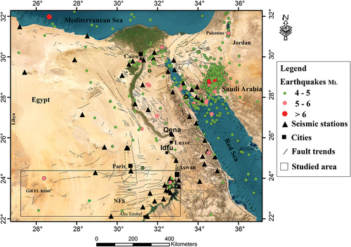
Figure 1. Location map for Gilf El Kebir studied area with seismicity ML > 4 from 1970 to 2022.
On 9 December 1978, a body wave magnitude 5.3 event was occurred in the southwestern part of the Western Desert in the sandstone plateau of the Gilf El Kebir. This event was the first and only instrumentally detected earthquake in this unpopulated region. On 14 November 1981, a large significant event with Mw = 5.8 impacted the eastern edge of this zone. The focal mechanism solution of 14 November 1981, displayed a pure strike-slip faulting mechanism along either ENE striking plane with a right lateral motion or NW striking plane with left-lateral motion (Woodward-Clyde Consultants., 1985; Global Centroid Moment Tensor, Citation1981). On the contrary 9 December 1978, displayed strike-slip faulting mechanism with a small thrust component along either ENE striking plane with a right lateral motion or NNW striking plane with a left-lateral motion (Maamoun et al. Citation1980). These solutions manifested that the earthquakes in the south of the Western Desert tectonic zone are predominantly strike-slip in contrast with the northern Egyptian unstable shelf earthquakes, which are characterised by normal faulting dip-slip motion (Hussein et al. Citation2013; Abdelazim et al. Citation2016). The focal mechanism solution of the 9 December 1978 earthquake manifested a thrust component that did not match the faulting style in the southern Western Desert zone. Therefore, we will reconsider the focal mechanism solution of this event through the grid search technique. On 19 February 2021, at 08:40 am, a body wave magnitude of 4.3 earthquake occurred in the same tectonic zone. This event was recorded by 16 seismic stations from the Egyptian National Seismic Network (ENSN) which facilitate creation of the focal mechanism solutions. Another event took place in the same zone on 7 November 2010 (ML = 4.6). The mechanism solution of this event manifested strike slip faulting mechanism (Saadalla et al. Citation2020). The Investigation the focal mechanism solution of this event, besides the focal mechanism solutions of the 1978, 1981, 2010 and 2021 earthquakes, would contribute to our understanding of the seismotectonic of the south of the Western Desert tectonic zone and its relationship to the regional stress that induced deformation in this zone.
2. Structural setting
The Nubian Fault System (NFS) is a system that covers hundreds of kilometres throughout Egypt’s stable shelf region, from the Nile across the southwestern corner of the Western Desert. The deformation style of the NFS is the surface representation of deep shear zones created through the accretion of the Arabian-African shield (Sakran and Said Citation2018). The NFS is composed of several E-W Principal Deformation Zones (PDZ) characterised by Late Cretaceous to present intra-plate strike-slip faults and related fold structures, as well as basement uplifts in some cases (Said et al. Citation2016). High-strain simple shear may have contributed to the creation of the NFS (Sehim Citation1993). The E-W trending faults (Guiraud et al. Citation1985), which encompass the entire African continent, are a component of the so-called Guinean-Nubian E-W trending lineaments. The E-W, ENE, and WNW striking right-lateral strike-slip faults, the N-S, NNE, and NNW striking left-lateral strike-slip faults, NE to ENE folds, and NW normal faults distinguish each PDZ in the southeast of the Western Desert (Sakran and Said Citation2018). The E-W and the N-S strike-slip faults with a dextral and sinistral sense of movement, respectively, are the most noticeable striking trends in the Nubian Desert (Woodward-Clyde Consultants Citation1985). The E-W faults mainly governed the southern Western Desert. They are longer than the N-S faults, have experienced more activity in the Quaternary, and have experienced more significant displacement than the N-S faults (Woodward-Clyde Consultants Citation1985). The general fault system of the NFS is a typical illustration of Riedel shears, indicated by WNW (R), ENE (P), NNE (R’) conjugate shear, NE reverse faults and NW extensional faults (Sakran and Said Citation2018). According to (Issawi Citation1968) and (Tewksbury et al. Citation2017), NFS are dip-slip Cenozoic extensional faults. According to (Sakran and Said Citation2018), NFS was reactivated by dextral transpression through the Late Cretaceous – Middle Eocene (Sehim Citation1993) manifested that the E-W trending faults experienced two distinct phases of strike-slip motion throughout the late Cretaceous and early Tertiary.
According to the most recent studies, the pre-existing Precambrian NFS was developed as transcurrent faults as a consequence of the far-field stress transfer linked with the opening of the Red Sea during the Late Oligocene (24 Ma) (Abdeen et al. Citation2001; Said et al. Citation2016) or transpressional faults resulting from the collision between the African and the Eurasian plates during Late Santonian-Maastrichtian times (84–65 Ma) (Bosworth et al. Citation1999; Guiraud et al. Citation2001, Citation2005; Youssef Citation2003).
The geological map () of the southwest of the Western Desert region shows four oriented normal faults, including E-W, ENE-WSW, NNE-SSW and NW-SE (Egyptian mineral resources authority, updated Citation2008), as well as E-W trending strike-slip faults (Guiraud et al. Citation2000; El Kady Citation2003). The stress field in the stable shelf’s Nubian Fault System (NFS) zone is mainly strike-slip with a consistent E-W SHmax (Bosworth and Strecker Citation1997; Badawy Citation2001), whereas the stress field in the unstable northern shelf is mainly transtensional with a consistent NW-SE SHmax (Badawy Citation2001). According to Zoback (Citation1992), the plate boundary force is the cause of this intra-plate stress field. The Red Sea active plate margin differential spreading rate North and South of the region between 22° and 24° N is responsible for the current stress regime () along the Nubian Fault System (NFS) (Woodward-Clyde Consultants Citation1985). This differential rate generates an E-W shear couple which brings compression force to the area west of the Red Sea, resulting in a right lateral strike-slip motion along the E-W trending faults. The eastern end of the E-W faults is accommodated mainly by a few secondary N-S left-slip faults.
Figure 2. a) geological map modeified after Egyptian Mineral Resources Authority (EMRA) Citation2008 b) focal mechanism solution of earthquakes in the studied and adjacent areas, and in the Gebco (Citation2019) digitial elevation model base map (Tozer et al. Citation2019).
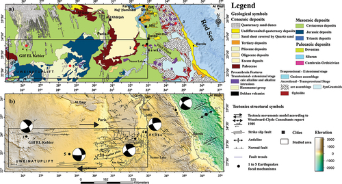
Table 1. Focal mechanism solutions used in this study and adjacent areas for earthquakes with magnitude (ML)>4.6.
3. The focal mechanisms
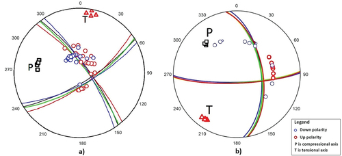
The focal mechanism solutions of the largest earthquakes in this zone are shown in and the parameters of these solutions are listed in . We calculated the focal mechanism solution only for the 1978 Gilf El Kebir earthquake and 19 February 2021 (; ). The 1978 earthquake solution is recovered from the polarity inversion of the P-wave first-onset of 58 stations extracted from the International Seismological Center (ISC) bulletin, using the FOCMEC algorithm (Snoke Citation2003). The stations used in this solution are located at epicentral distances ranging from 17 to 78 degrees. The gap between the event-station azimuths is 130°. FOCMEC is a grid search technique that looks for the double-couple fault plane solution over a focal sphere giving the best possible fit of a given set of first-motion polarity data identified for an earthquake, harmonious to a set of rotated orthogonal B, A and N axes. Finally, it provides acceptable solutions according to the number of permissible polarity errors. The grid search over the focal sphere necessitates a velocity model to calculate the incidence angle and Azimuth. We used the crustal model for the Western Desert (Marzouk and Makris Citation1990). In the current study, we used a 2° grid search interval. We found 10 acceptable solutions, with dip and rake angles of the first nodal plane ranging from 74° to 82° and −26° to −11°, respectively, and dip and rake angles of the second nodal plane ranging from 64° to 71° and −171° to −163°. The strike angle of the first nodal plane range from 318° to 328° while the strike angle of the second nodal plane is between 54° and 63°. The focal mechanism solution of the 1978 event displays a strike-slip faulting mechanism along two nodal planes orientated in the ENE and NW directions, respectively.
Figure 3. a). 9 December 1978 earthquake, M5.3, b). 19 February 2021 earthquake, M4.6.
4. Discussion and conclusions
Based on surface geology, and geophysical data, it is evident that the southern part of the Western Desert is controlled mainly by the Nubian Fault System (NFS). The majority of the NFS are mainly pre-existing E-W striking strike-slip faults of the Precambrian age. Among the NFS in the southeast of the Western Desert, there are three main types: NW normal faults, E-W, ENE and WNW conjugate right-lateral strike-slip faults, and N-S, NNE and NNW conjugate left lateral strike-slip faults (Sakran and Said Citation2018). According to the Egyptian Mineral Resources Authority (EMRA) map, the South Western Desert region exhibits four directions of normal faults, including E-W, ENE-WSW, NNE-SSW, and NW-SE trending faults, as well as E-W trending strike-slip faults (Guiraud et al. Citation2000 El Kady Citation2003).
The focal mechanism solutions of the 1978, 1981, 2010 and the 2021 events, which took place in the southern part of the Western Desert tectonic zone, are comparable, demonstrating that this zone is under uniform stress. The four events show strike-slip faulting mechanisms along the E-W trending faults, which are a part of the so-called E-W trending Guinean-Nubian lineaments. The compressional force resulting from the differential spreading rate in the Red Sea north and south of the zone between 22° and 24° N caused a shear couple that rejuvenates the pre-existing Precambrian NFS. The 1984 Abu Dabbab earthquake (MW = 5.3) which occurred close to the Red Sea coast south of 26° N supported the hypothesis. This event also displays a strike-slip faulting mechanism (Hussein et al. Citation2011) similar to 1978, 1981, 2010 and 2021. In addition, the focal mechanisms for the 1984 event and the other four South of the Western Desert earthquakes are also different from those in the northern Egyptian unstable shelf as they showed normal faulting mechanisms with some strike slip component. This confirms that the tectonics of the Gilf El Kebir area is mainly related to the rifting and opening of the Red Sea, which started in the Oligocene and continues today. The Gilf El Kebir lacks information on seismic activities due to insufficient seismic stations to cover the area far west of Aswan in the non-inhabited lands. The mechanism for the 1955 Abu Dabab event (mb = 6.1) located very close to the 1984 Abu Dabab earthquake was poorly constrained to limited number of available stations at this time (Woodward-Clyde Consultants Citation1985). Therefore, we neglected this solution due to the large azimuth gap.
Disclosure statement
No potential conflict of interest was reported by the author(s).
References
- Abdeen MM, Thurmond AK, Abdelsalam MG 2001. Application of ASTER band ratio images for geological mapping in arid region: the neoproterozoic allaqi suture, Egypt. GSA Annual Meeting, p. 5–8, Boston, Massachusetts. http://gsa.confex.com/gsa/2001AM/finalprogram/abstract_27348.htm.
- Abdelazim M, Samir A, Abu El-Nader I, Badawy A, Hussein H. 2016. Seismicity and focal mechanisms of earthquakes in Egypt from 2004 to 2011. NRIAG J Astron Geophys. 5(2):393–402. doi: 10.1016/j.nrjag.2016.08.002.
- Ambraseys NN, Melville CP, Adams RD. 1994. The seismicity of Egypt, Arabia and Red Sea. Cambridge University Press. doi: 10.1017/CBO9780511524912.
- Badawy A. 2001. The present-day stress field in Egypt. Ann Geofis. 44(3):557–570. doi: 10.4401/ag-3575.
- Bertarelli LV. 1929. Guida d’Italia. Vol. XVII, (in Italian). Milano: Consociazione Turistica Italiana.
- Bosworth W, Guiraud R, Kessler LG. 1999. Late Cretaceous (ca. 84 Ma) compressive deformation of the stable platform of northeast Africa (Egypt): far-field stress effects of the “Santonian event” and origin of the Syrian arc deformation belt. Geology. 27(7):633–636. doi: 10.1130/0091-7613(1999)027<0633:LCCMCD>2.3.CO;2.
- Bosworth W, Strecker MR. 1997. Stress field changes in the Afro-Arabian rift system during the miocene to recent period. Tectonophysics. 278(1–4):47–62. doi: 10.1016/S0040-1951(97)00094-2.
- Dziewonski AM, Chou T-A, Woodhouse JH. 1981. Determination of earthquake source parameters from waveform data for studies of global and regional seismicity. J Geophys Res: Atmos. 86:2825–2852. doi: 10.1029/JB086iB04p02825.
- Ekström G, Nettles M, Dziewonski AM. 2012. The global CMT project 2004-2010: centroid-moment tensors for 13,017 earthquakes. Physcis Of The Earth Planetary Interiors. 200-201:1–9. doi: 10.1016/j.pepi.2012.04.002.
- El Kady MFM (2003). Structural evolution in the palaeoproterozoic basement (banded iron formation and related rocks) of SW Egypt. PhD thesis, Ruprecht-Karls Univ. Heidelberg. DOI: 10.11588/heidok.00003573.
- GEBCO Bathymetric Compilation Group. 2019. The GEBCO grid - a continuous terrain model of the global oceans and land. NERC, UK: British Oceanographic Data Centre, National Oceanography Centre. doi: 10.5285/836f016a-33be-6ddc-e053-6c86abc0788e.
- Guiraud R, Bosworth W, Thierry J, Delplanque A. 2005. Phanerozoic geological evolution of northern and central Africa: an overview. J Afr Earth Sci. 43(1–3):83–143. doi: 10.1016/j.jafrearsci.2005.07.017.
- Guiraud R, Issawi B, Bellion Y. 1985. Les linéaments guinéo-nubiens: un trait structural majeur à l’échelle de la plaque africaine. C R Acad S C Paris. 300:17–20.
- Guiraud R, Issawi B, Bosworth W. 2001. Phanerozoic history of Egypt and surrounding areas. In: Ziegler PA, Cavazza W, Robertson AHF, and Crasquin-Soleau S, editors. Peri-tethys memoir 6: peri tethyan Rift/Wrench basins and passive margins. Me´moires du Muse´um national d_Histoire naturelle de Paris 186. Les Mémoires du Muséum national d’Histoire naturelle de Paris publient; pp. 469–509.
- Guiraud R, Jean Claude DM, Carretier S, Dominguez S. 2000. New evidence for a 6000 km length NW–SE-striking lineament in northern Africa: the Tibesti lineament. J Geol Soc (London). 157(5):897–900. doi: 10.1144/jgs.157.5.897.
- Hussein HM, Abou Elenean KM, Marzouk IA, Korrat IM, Abu El-Nader IF, Ghazala H, ElGabry MN. 2013. Present-day tectonic stress regime in Egypt and surrounding area based on inversion of earthquake focal mechanisms. J Afr Earth Sci. 81:1–15. doi: 10.1016/j.jafrearsci.2012.12.002.
- Hussein HM, Moustafa SSR, ELawadi E, Al-Arifi NS, Hurukawa N. 2011. Seismological aspects of the Abou Dabbab region, eastern Desert, Egypt. Seismol Res Lett. 82(1):81–88. doi: 10.1785/gssrl.82.1.81.
- Issawi B 1968 The geology of kurkur—dungul area. Geological Survey, Paper No. 46. Egypt, 102
- Maamoun M, Allam A, Megahid A, Abu El-Ata A. 1980. Neotectonics and seismic regionalization of Egypt. Bull of the Inter Inst of Seism and Earthquake Eng. 18:27–39.
- Maamoun M, Megahed A, Allam A. 1984. Seismicity of Egypt. Bulln of heln Instit Astro and Geophy. IV(B):109–160.
- Mansour M. 2008. Egyptain geological map. Egyptian mineral resources authority.
- Marzouk I, Makris J. 1990. Deep seismic profiles in Egypt. Bull Int Inst Seismol Earthq Eng. 24:1–40.
- Mohamed HH, Gaber HH, Sayed AD, Ezzat ME. 2008. A review of the recent seismic activity in the southern part of Egypt (Upper Egypt). Acta Geodynamica Et Geomaterialia. 5(1):51–64.
- Moustafa SSR, Abdalzaher MS, Abdelhafiez HE. 2022. Seismo-lineaments in Egypt: analysis and implications for active tectonic structures and earthquake magnitudes. Remote Sens. 14(23):6151. doi: 10.3390/rs14236151.
- Saadalla H, Abdel–Aal Ak, Mohamed AN, El-Faragawy K. 2020. Characteristics of earthquakes recorded around the high dam lake with comparison to natural earthquakes using waveform inversion and source spectra. Pure Appl Geophys. 177(8):3667–3695. doi: 10.1007/s00024-020-02490-4.
- Said I, Massironi M, Zampieri D, Sakran S, Ninfo A. 2016. Strike-slip Structure and Kinematics of the Nubian Faults, South Egypt. European Association of Geoscientists & Engineers, 78th EAGE Conference and Exhibition 2016. 1–3. doi: 10.3997/2214-4609.201600907.
- Sakran S, Said SM. 2018. Structural setting and kinematics of Nubian fault system, SE Western Desert, Egypt: an example of multi-reactivated intraplate strike-slip faults. J Struct Geol. 107:93–108. doi: 10.1016/J.JSG.2017.12.006.
- Sehim A. 1993. Cretaceous tectonics in Egypt. Eg J Geol. 37:335–372.
- Snoke JA. 2003. FOCMEC: focal mechanism determinations. International Geophysics. 81:1629–1630. 85.12.
- Tewksbury BJ, Mehrtens CJ, Gohlke SA, Tarabees EA, Hogan JP. 2017. Constraints from mesozoic siliciclastic cover rocks and satellite image analysis on the slip history of regional E-W faults in the southeast Western Desert, Egypt. J Afr Earth Sci. 136:119–135. doi: 10.1016/j.jafrearsci.2017.06.026.
- Tozer B, Sandwell DT, Smith WHF, Olson C, Beale JR, Wessel P. 2019. Global bathymetry and topography at 15 arc sec: SRTM15+. Earth And Space Science. 6(10):1847–1864. doi: 10.1029/2019EA000658.
- Woodward-Clyde Consultants (WCC). 1985. Identification of earthquake sources and estimation of magnitudes and recurrence intervals internal report high and Aswan Dams authority. Egypt 135pp.
- Youssef MM. 2003. Structural setting of central and south Egypt: an overview. Micropaleontology. 49(Suppl_1):1–13. doi: 10.2113/49.Suppl_1.1.
- Zoback ML. 1992. First- and second-order patterns of stress in the lithosphere: the world stress map project. J Geophys Res: Atmos. 97(B8):11703–11728. doi: 10.1029/92JB00132/.