
 ?Mathematical formulae have been encoded as MathML and are displayed in this HTML version using MathJax in order to improve their display. Uncheck the box to turn MathJax off. This feature requires Javascript. Click on a formula to zoom.
ABSTRACT
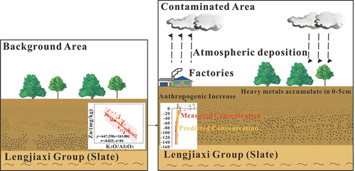
Evaluating the variation in heavy metal concentrations in soil caused by anthropogenic activities in heavily contaminated areas is of great significance. The degree of heavy metal pollution in soil is primarily assessed by different indices with different standards and reference elements. However, these methods cannot be used to evaluate the degree of heavy metal pollution caused by anthropogenic activities. In this study, Zhuzhou, China was selected as the contaminated area, and Yueyang, China was selected as the background area, where geological and climatic conditions are similar to those of Zhuzhou, China. The concentrations of As (6.6–23.6 mg/kg), Cd (0.125–0.757 mg/kg), Cu (33–75 mg/kg), Hg (0.032–0.202 mg/kg), Pb (17–108 mg/kg), and Zn (74–122 mg/kg) in the vertical soil profiles in the contaminated area were higher than those in the background area (ranging 1.7–20.7, 0.085–0.210, 21–47, 0.030–0.105, 17–38 and 32–88 mg/kg, respectively). K2O/Al2O3, SiO2/Al2O3, and the weathering leaching coefficient (ba) showed little difference, suggesting that the weathering degree of soil in these two areas was similar. The weathering degree of soil governs the geochemical behavior of heavy metals and reference elements. According to the prediction models for heavy metal concentrations and organic carbon, K2O/Al2O3, and SiO2/Al2O3 in the soil profiles from the background area, the increase in heavy metal concentrations in the topsoil in the contaminated area was depicted. The heavy metal concentrations in topsoil were obviously affected by anthropogenic activities. This study provides a case study for evaluating the impact of anthropogenic activities on heavy metals in soil.
GRAPHICAL ABSTRACT
1. Introduction
As the most important natural resource, soil is the carrier of biological survival and breeding. The National Soil Pollution Status Survey Bulletin of China indicates that the total soil pollution rate exceeding the standard values in China is 16.1% [Citation1]. Heavy metal contamination in soil is particularly prominent. Heavy metals in soil can readily accumulate and hardly be decomposed [Citation2]. They easily migrate to crops and water bodies, causing serious pollution and threatening crop growth and affecting human health [Citation3]. The extent of heavy metal contamination in soil was assessed using different methods, indices, standards, and reference elements [Citation4]. Many assessment methods for heavy metal pollution have been widely cited [Citation5-9], such as the single pollution index, geo-accumulation index (Igeo), enrichment factor (EF), and the Nemerow index etc. Common reference standards include upper continental crust, global average concentrations, national soil background concentrations, local background concentrations, and soil environmental quality standards. Significant differences exist between the assessment results for the pollution extent of heavy metals in soil using different reference standards. For example, Yu et al. [Citation10] found that the concentration of heavy metals in the farmland soil around a mining site in Hunan Province exceeded the background concentration of Hunan Province by 5.7 times. However, it did not exceed the risk intervention values specified in the Chinese Environmental Quality Standard for Soils [Citation10]. In generally, local background concentrations are considered reliable reference standards [Citation11].
Common reference elements include Al [Citation12], Fe [Citation13], Se [Citation14], Ti [Citation15], and Zr [Citation11]. The concentrations of the different reference elements varied significantly, which one is more suitable as a reference element is not universal. Different reference elements would lead to completely different assessment results for the degree of heavy metals pollution [Citation16]. Concentrations of reference elements in topsoil also change under the influence of weathering, pedogenesis, and anthropogenic activities [Citation17]. In addition, the geochemical behaviors of the reference elements and heavy metals could vary considerably. For example, Cu, Ni, or Zn adsorb onto fine Fe and Mn oxy-hydroxides or clay minerals that are prone to be windblown during weathering. In contrast, Ti and Sc commonly occur in high-specific-gravity minerals that are not easily transport aerially [Citation17]. The selection of appropriate reference elements (or indicators) for heavy metals requires further discussion. Concentrations of heavy metals in the topsoil higher than the reference standard may not directly reflect the degree of anthropogenic contamination of heavy metals in soil. The sources of high concentrations of heavy metals in topsoil are complex: 1) high concentrations of heavy metals in soil parent materials, such as black shale [Citation18], basalt [Citation19], and polymetallic deposits [Citation20]; 2) heavy metals enriched in topsoil under pedogenesis, such as karst areas [Citation21] 3) high concentrations of heavy metals in the soil of alluvial plains governed by rock weathering and soil erosion upstream, such as the Pearl River Delta [Citation22] and 4) high concentrations of soil heavy metals caused by anthropogenic activities [Citation23]. Therefore, a comprehensive, reasonable, and scientific evaluation of the degree of anthropogenic contamination heavy metals in soil must be conducted. It is a cornerstone for the identification of pollution sources and the monitoring and remediation of heavy metal contamination in soil, which are crucial steps for formulating environmental pollution policies.
Zhuzhou, a typical heavy-industry city in China [Citation24], has several developed industries and abundant mineral resources. After 50 y of development, Zhuzhou has become an industrial hub that integrates metallurgy, machinery, chemical engineering, building materials, raw material manufacturing, high-tech, and state-owned large- and medium-sized enterprises [Citation25]. Pollution sources and ecological and health risk assessments of heavy metals in soil, atmospheric deposition, particulate matter, sediments, and plants have raised widespread concern. The concentrations of As, Cd, Cu, Pb, and Zn in the topsoil were higher than the values specified by the Chinese Environmental Quality Standard for Soil [Citation25]. Recently, the government has increased efforts to control pollution in the Qingshuitang Core Industrial Zone in Zhuzhou [Citation26]. It is necessary to evaluate the degree of soil heavy metal contamination caused by anthropogenic activities in this region for developing environmental pollution control policies. Based on the multi-purpose regional geochemical survey of Hunan Province [Citation27], this study collected and measured vertical soil profiles from natural forest land in background and contaminated areas where geological and climatic conditions are similar. The objectives were to: 1) depict the differences in concentrations of heavy metals and other physicochemical parameters in vertical soil profiles; 2) identify the factors governing the concentrations of heavy metals in vertical soil profiles from the background area; 3) select appropriate reference elements (or indicators), and establish prediction models for concentrations of heavy metals in soil by fitting the correlation between them and reference elements (or indicators) in the background area; and 4) predict the concentrations of heavy metals in topsoil from the contaminated area using the above-mentioned models, and evaluate the concentration increase of soil heavy metals in the contaminated area.
2. Materials and methods
2.1. Study area
Zhuzhou (26°03′05″–28°01′07″ N, 112°57′30″–114°07′15″ E) is located east of Hunan Province and downstream of the Xiangjiang River. It has a subtropical monsoon climate. The annual precipitation is approximately 1391.9 mm with an average temperature of 16–18°C [Citation28]. Zhuzhou is a typical industrial base established in the 1950 s. It has developed large-scale heavy chemical enterprises, represented by the Zhuzhou Smelter and Zhuzhou Chemical Plant [Citation26], which have contributed substantially to the industrial development of China. However, decades of industrial development have caused severe environmental pollution in Zhuzhou [Citation29]. The strata in Zhuzhou City are widely distributed, from Proterozoic to Quaternary. The types of soil forming parent rocks in the area are complex, the lake area is mainly composed of river sediments, while the hill area is mainly composed of sandstone, slate, limestone, granite, et al.
According to the multi-purpose regional geochemical atlas of Dongting Lake, the concentrations of heavy metals in the topsoil of Yueyang were lower than those in Zhuzhou [Citation30]. Atmospheric deposition is an important contributor of heavy metals in the soil [Citation31]. The annual flux of atmospheric deposition in Zhuzhou is substantially higher than that in Yueyang [Citation32]. Moreover, the median concentrations of Cd, Pb, and As in atmospheric deposition in Zhuzhou were significantly higher than those in Yueyang [Citation33]. Therefore, this study selected Yueyang as the background area, and Zhuzhou as the contaminated area (). To avoid the influence of parent materials and local anthropogenic activities on the concentration of heavy metals in soil, the vertical soil profiles of natural forest land were collected in the distribution area of the Lengjiaxi Group in Zhuzhou and Yueyang. The Lengjiaxi Group is the oldest exposed stratum in Hunan Province and is composed of extremely thick clastic, argillaceous, and tuffaceous rocks with a specially developed sedimentary rhythm [Citation34].
Figure 1. Map of the study area.

2.2. Environmental setting and soil sampling
Six vertical soil profiles of natural forest land were collected from the background and contamination areas. Sites for vertical soil profiles were chosen based on a geological lithological map to represent their parent materials (Lengjiaxi Group). They are far from the known sources of pollution. Therefore, heavy metal concentrations in soil are only governed by the parent material and atmospheric deposition. The vertical soil profile samples were collected from pits to avoid evidently disturbed or contaminated ground. Soil samples were collected from the bottom to the top at 5-cm intervals. The depth of each profile was different. The actual depth is subject to the emergence of bedrock or groundwater. The depth of the vertical soil profiles ranged from 100 to 150 cm. Six vertical soil profiles and 164 soil samples were collected ().
Figure 2. Sampling points of vertical soil profiles in the study area.

All sampling positions were determined using a global positioning system. Visible plant detritus and rock fragments were manually removed from soil samples. After air drying, the samples were crushed using a wooden hammer, sieved to pass through a 20-mesh (<0.84 mm) nylon sieve, and further processed with a 200 mesh (<0.074 mm) for analysis.
2.3. Laboratory analysis procedures
The soil samples were analyzed at the Hefei Mineral Resources Supervision and Testing Center, Ministry of Land and Resources, People’s Republic of China. The samples were pelletized and analyzed by wavelength dispersive X-ray fluorescence spectrometry (PANalytical AXIOS, PW 4400) for Al2O3, CaO, K2O, MgO, Na2O, SiO2, TFe2O3, and Ti. Calibrations were conducted using certified reference materials, and α-correction was applied to correct for matrix interference. To analyze the concentrations of trace elements, the soil samples were digested using a mixture of HClO4, HNO3, and HF in Teflon tubes. The residue was then dissolved in aqua regia, and the supernatant was pipetted and diluted with HNO3 (3%). Arsenic, Hg, and Ge were tested using atomic fluorescence spectrometry (AFS-3100; Beijing Haiguang Instrument Corporation, China). Furthermore, Cd, Cu, Mn, Pb, Sc, Th, and Zn were analyzed using inductively coupled plasma mass spectrometry (ICAP-7400, Thermo Fisher Scientific, U.S.A.). The concentration of organic carbon (OC) was determined by wet oxidation in an acid dichromate solution, followed by back titration of the remaining dichromate using a ferrous ammonium sulfate solution. Soil pH was measured with carbon dioxide-free water (1:2.5, w/w) using a pH meter (PHS-3CF, Chuangfa, Inc., China). The soil samples were analyzed for grain size distribution by wet sieving and sedimentation according to the Koehn-pipette method.
Standard reference and replicate samples were used to monitor trueness, repeatability, accuracy, and precision. Analytical accuracy is measured by logarithmic deviation () [Citation35], which is defined as
where is the average of 12 measured concentrations of the standard reference and
is the recommended concentration of the standard reference.
The analytical precision is expressed by the relative deviation (RD), which is calculated as follows:
where A and B are the two measured concentrations of the standard reference and replicate samples, respectively.
The accuracy and precision of the elemental analyses of all samples were less than 0.04 and 23%, respectively, which met the quality requirements.
2.4. Statistical analysis
Statistical analysis was performed and the figures generated using IBM SPSS Statistics 22.
The geoaccumulation index was proposed by Muller and is suitable for urbanization or industrialized regions with strong anthropogenic activities. The Igeo was calculated as follows:
where is the measured concentration of heavy metal ‘i’ and
is the geochemical background concentration of the metal. The factor 1.5 is used because of possible variations in background values due to lithological variability [Citation9].
Igeo0, unpolluted; 0< Igeo
1, unpolluted to moderately polluted; 1< Igeo
2, moderately polluted; 2< Igeo
3, moderately to highly polluted; 3< Igeo
4, highly polluted; 4< Igeo
5, highly to very highly polluted; Igeo >5, very highly polluted.
The weathering leaching coefficient (ba) refers to the molecular ratio of oxides of various bases in the soil to alumina [Citation36]. The ba was calculated as follows:
It is usually used to indicate the weathering degree of soil [Citation37]. The lower the ba value is, the stronger the degree of weathering leaching is [Citation38].
SiO2/Al2O3 refers to the molecular ratio of oxides of silicon to alumina. It can reflect the weathering degree of the soil. K2O/Al2O3 refers to the molecular ratio of oxides of potassium to alumina. It may reflect the stage of chemical weathering of K-rich minerals.
2.5. Model validation
Fitting models were using Origin 2021b. The root mean square error (RMSE), mean absolute error (MAE), mean root error (MRE) and correlation coefficients (r) are common indexes to evaluate the accuracy of prediction models. Smaller RMSE, MAE, and MRE mean smaller error and higher prediction accuracy [Citation39]. The r is used to evaluate the goodness for fit of prediction models. The larger the r is, the better the prediction performance of the model is.
3. Results and discussion
3.1. Geochemical characteristics of vertical soil profiles
The statistical characteristics of the physicochemical parameters of the vertical soil profiles are shown in Table S1 and .
Figure 3. Vertical distributions of heavy metals and other geochemical parameters in vertical soil profiles in the study area. Vertical soil profiles numbered B1, B2 and B3 from the background area; Vertical soil profiles numbered P1, P2 and P3 from the contaminated area.

The concentrations of As, Cd, Cu, Hg, Pb, and Zn in the vertical soil profiles in the background area were lower than those in the contaminated area. For example, the average concentrations of Cd in vertical soil profiles from the background area are 0.114, 0.127, and 0.111 mg/kg, respectively, whereas the average concentrations of Cd in vertical soil profiles from the contaminated area are 0.206, 0.316, and 0.238 mg/kg, respectively. Cd, Hg, Pb, and Zn are generally enriched in the topsoil in the contaminated area. The Cu concentration varies slightly in vertical soil profiles, whereas As concentration changes considerably. The average concentrations of As in the vertical soil profiles from the background area are 17.0, 13.2, and 5.9 mg/kg, respectively, whereas the average concentrations of As in the vertical soil profiles from the contaminated area are 18.5, 13.9, and 12.2 mg/kg, respectively. The variation in As in the vertical soil profiles from the background area is slightly lower than that in the contaminated area.
Little variation is observed in the ba of the vertical soil profiles between the background and contaminated areas, indicating that the weathering degree of soil in the two areas is highly similar. The SiO2/Al2O3 ratio primarily reflects the abundance of quartz, clay, and feldspar [Citation40], and can approximately reflect the weathering degree of soil. The SiO2/Al2O3 ratio of the vertical soil profiles in the contaminated and background areas remains relatively constant (ranging 4.90–6.76 and 4.68–7.78, respectively), which corresponds to the initial to moderate weathering stages. The change in the K2O/Al2O3 ratio primarily depends on the mobility of K during weathering. K is partially leached into the solution during weathering and migrates in the form of K+, whereas Al is absorbed by secondary minerals and retained in the residual phase. Strong rainfall results in high K loss and a low K2O/Al2O3 ratio [Citation41,Citation42]. The K2O/Al2O3 ratio of the soil profile in the background area is slightly higher than that in the contaminated area.
The variation in the concentrations of Ti and TFe2O3 in the vertical soil profiles from the background area are high. In contrast, their concentrations in the vertical soil profiles from the contaminated area are relatively stable and are generally slightly higher than those from the background area. The pH value in the topsoil is lower than that in the deep soil, indicating that the alkaline elements in the topsoil were leached seriously in the two study areas. Generally, the soil in the study areas is weakly acidic or acidic (ranging 4.3–6.0). The OC is characterized by the enrichment of topsoil, and the concentration characteristics and change trends of OC in the vertical soil profiles from the background and contaminated areas are extremely similar (ranging 0.09–2.07 and 0.22–2.92). The clay concentration in the vertical soil profiles from the contaminated area (ranging 12.05–24.77) is slightly higher than that from the background area (ranging 5.23–15.69).
3.2. Factors influencing heavy metals in the vertical soil profiles
To analyze the geochemical behavior of heavy metals during pedogenesis, we calculated the correlation coefficients between heavy metals and other geochemical parameters in vertical soil profiles in the background area ().
Table 1. Correlation coefficients between heavy metals and other geochemical parameters in vertical soil profiles from the background area.
Arsenic is negatively correlated with pH, K2O/Al2O3, and ba, and positively correlated with clay, Ti, and Th. Moreover, Cd is negatively correlated with pH, Al2O3, and Sc and positively correlated with OC, SiO2/Al2O3, ba, and Ti. Furthermore, Cu is negatively correlated with K2O/Al2O3, SiO2/Al2O3, and ba, and positively correlated with clay, TFe2O3, Al2O3, Ge, Sc, and Th. We found that Hg is negatively correlated with pH and SiO2/Al2O3 and positively correlated with TFe2O3, Al2O3, Ge, Sc, and Th. Additionally, Pb is negatively correlated with pH and SiO2/Al2O3 and positively correlated with OC, clay, TFe2O3, Al2O3, Ge, Sc, and Th. Zn is negatively correlated with pH, K2O/Al2O3, and ba, and is significantly correlated with clay, Ti, and Th.
In general, a lower pH is more conducive to the migration of heavy metals [Citation43], which is also confirmed by the negative correlation between the six heavy metals and pH. Moreover, As, Cd, Pb, Zn, and Hg are positively correlated with OC. OC has a certain adsorption effect on heavy metals; therefore, complexation and chelation occur easily [Citation44]. Positive correlations exist between clay content and six heavy metals. Clay minerals have a large specific surface area and adsorption effect on heavy metals [Citation45]. Al2O3, TFe2O3, Ge, Sc, Ti, and Th tend to be gradually enriched in residues during chemical weathering and pedogenesis. Al2O3 and Fe2O3 are the main components of secondary clay minerals and iron hydroxides, respectively. Some inert trace elements can be adsorbed onto the surface of these secondary minerals or enter their lattices [Citation46]. The lower the K2O/Al2O3, SiO2/Al2O3, and ba values of the soil, the stronger the weathering degree of soil. Except for As and Cd, the concentrations of Cu, Hg, Pb, and Zn increase with the degree weathering of soil, which can be affected by the secondary minerals in soil [Citation47].
3.3. Determination of reference indicators
Al, Fe, Ti, Th, Zr, and other elements are commonly used as reference elements to evaluate the enrichment of heavy metals in soil. The correlation coefficients between these reference elements and the basic physicochemical properties of soil (pH, OC, and clay content) and indicators representing the weathering degree (K2O/Al2O3, SiO2/Al2O3, and ba) are presented in this study. All the reference elements are highly correlated with K2O/Al2O3, SiO2/Al2O3, and ba (, ). The reference elements that are highly correlated with the clay content are also highly correlated with K2O/Al2O3. Therefore, we concluded that the degree weathering and pedogenesis affects the geochemical behavior of reference elements and heavy metals in the soil simultaneously.
Figure 4. Analysis of the relationship between the weathering indicators and reference elements.

Table 2. Correlation coefficients of common reference elements and main physicochemical properties.
Arsenic and Zn are highly correlated with K2O/Al2O3, Ti and Th. Ti and Th are also highly correlated with K2O/Al2O3 (). The correlation between As, Zn, and K2O/Al2O3 is stronger than that between As, Zn, and Ti, Th. Therefore, K2O/Al2O3 was selected as the reference indicator for As and Zn in the study. The correlation coefficient between Cd and OC is 0.780, which is considerably higher than its correlation coefficient with other indicators. Although some studies have shown that Cd is related to ferromanganese (hydrogen) oxides in soil [Citation48], the correlation between Cd and TFe2O3 on the vertical soil profiles in the background area is weak. The correlation of Cd is also not strong with various indicators representing the weathering degree. Therefore, OC was selected as a reference indicator for Cd in soil. Cu, Hg, and Pb are highly correlated with TFe2O3, Al2O3, Ge, Sc, and Th (), and TFe2O3, Al2O3, Ge, Sc, and Th are highly correlated with SiO2/Al2O3 (, ). This indicated that the concentrations of TFe2O3, Al2O3, Ge, Sc, and Th are affected by the weathering degree of soil. Therefore, SiO2/Al2O3 was selected as a reference indicator for Cu, Hg, and Pb.
3.4. Assessment of anthropogenic contamination
According to Igeo values, 93.75% As values were found to be unpolluted and 6.25% were found to be unpolluted to moderately polluted. 56.25% Cd were found to be unpolluted to moderately polluted, 41.25% were found to be moderately polluted, and 2.50% were found to be moderately to highly polluted. 37.50% Cu were found to be unpolluted and 62.50% were found to be unpolluted to moderately polluted. 75.00% Hg were found to be unpolluted and 25.00% were found to be unpolluted to moderately polluted. 93.75% Pb were found to be unpolluted, 3.75% were found to be unpolluted to moderately polluted and 2.50% were found to be moderately polluted. 100% Zn were found to be unpolluted.
The fitting models for the concentrations of heavy metals in the vertical soil profiles from the background area are shown in . The prediction model validation results are shown in . The prediction model of Cd works best, followed by Hg, the r of all prediction models is high.
Figure 5. Correlations between heavy metal elements and reference indicators in vertical soil profiles from the background area.

Table 3. Validation results of prediction models.
These fitting models were then used to calculate the predicted concentrations of heavy metals in the vertical soil profiles from the contaminated area (). The differences between the predicted and measured concentrations of heavy metals were used to describe the degree of heavy metal contamination induced by anthropogenic activities in the contaminated area. Considering that the heavy metals input by atmospheric deposition in natural forest land primarily accumulate in 0–5 cm soil layer [Citation49]. The predicted concentrations, measured concentrations, the increase and increasing rates of heavy metal concentrations in 0–5 cm soil layer of vertical soil profiles in the contaminated area are shown in . Hg, Pb, and Cd have the highest increasing rates, which are 280%, 220%, and 158.02%, respectively, which are maybe caused by the atmospheric deposition of the factories. The results indicated that the topsoil in the contaminated area was strongly affected by anthropogenic activities. Compared to the results of Igeo, the increase in heavy metal concentrations in the contaminated area caused by anthropogenic activities can be reflect more accurately by establishing prediction models in the background area, which is closer to the real situation.
Figure 6. Vertical distributions of predicted and measured values for heavy metal elements in soil profiles from contaminated area.

Table 4. Comparison of measured and predicted concentrations of heavy metal elements in 0-5 cm soil layer of vertical soil profiles from the contaminated area.
4. Conclusion
In this study, the geochemical distribution and governing factors of heavy metals in vertical soil profiles of natural forest land from the background area (Yueyang, China) and contaminated area (Zhuzhou, China) were determined to assess the anthropogenic increase of heavy metals in soil from the contaminated area. Our study demonstrated that As, Cd, Cr, Hg, Pb, and Zn in vertical soil profiles from the contaminated area are significantly higher than those in the background area. The weathering degree of soil in the two areas is highly similar. Arsenic, Cd, Cr, Hg, Pb, and Zn are primarily correlated with the basic physicochemical parameters of soil (pH, OC, clay, and TFe2O3) and indicators representing the weathering degree of soil (K2O/Al2O3, SiO2/Al2O3, and ba) in vertical soil profiles from the background area. Common reference elements, such as Al, Fe, and Ti are significantly correlated with the indicators (K2O/Al2O3, SiO2/Al2O3, and ba) characterizing the weathering degree of soil. Therefore, we concluded that the weathering degree affects the geochemical behavior of reference elements and heavy metals in soil simultaneously. K2O/Al2O3 was selected as the reference indicator for As and Zn, OC as the reference indicator for Cd, and SiO2/Al2O3 as the reference indicator for Cu, Hg, and Pb. Fitting models were established for concentrations of heavy metals by the correlation between concentrations of heavy metals and reference indicators of vertical soil profiles from the background area. These fitting models were used to calculate the predicted concentrations of heavy metals in the vertical soil profiles from the contaminated area. The differences between the predicted and measured concentrations of heavy metals were used to describe the contamination degree of heavy metals in the 0–5 cm soil layer induced by atmospheric deposition in the contaminated area. Hg, Pb, and Cd have the highest increasing rates, which are 280%, 220%, and 158.02%, respectively, indicating that the topsoil in the contaminated area was strongly affected by anthropogenic activities. We strongly recommend that policy proposals be made to control the concentration of heavy metals in atmospheric deposition to reduce the contamination of heavy metals in soil.
Author contributions
Jiaxin Wang: Data analysis, Writing- Original draft preparation. Qingye Hou: Supervision, Conceptualization, Writing- Reviewing and Editing. Zhongfang Yang: Supervision, Writing- Reviewing. Tao Yu: Supervision, Writing- Reviewing, Riyang Wen: Writing- Reviewing.
Supplemental Material
Download MS Word (31.4 KB)Acknowledgments
This work was supported by the National Natural Science Foundation of China under Grant 41773019; the National Key R&D Program of China under Grant 2017YFD0800304; and the China Geological Survey Project under Grant 12120113002300, DD20160323.
Disclosure statement
The authors declare that they have no known competing financial interests or personal relationships that could have appeared to influence the work reported in this paper.
Data availability statement
Data will be made available on request.
Supplementary material
Supplemental data for this article can be accessed online at https://doi.org/10.1080/26395940.2023.2238895
References
- Ministry of Environmental Protection of the People’s Republic of China & Ministry of Land and Resources of the People’s Republic of China. The national soil pollution status survey bulletin. Beijing (China): R. China Environmental Science; 2014. http://www.mep.gov.cn.
- Zhang J, Liu Z, Tian B, et al. Assessment of soil heavy metal pollution in provinces of China based on different soil types: From normalization to soil quality criteria and ecological risk assessment. J Hazard Mater. 2022;441:129891. doi:10.1016/j.jhazmat.2022.129891
- Zeng J, Li C, Wang J, et al. Pollution simulation and remediation strategy of a zinc smelting site based on multi-source information. J Hazard Mater. 2022;433:128774. doi:10.1016/j.jhazmat.2022.128774
- Sakan S, Dević G, Relić D, et al. Evaluation of sediment contamination with heavy metals: the importance of determining appropriate background content and suitable element for normalization. J Environ Geochem Health. 2015;37(1):97–395. doi: 10.1007/s10653-014-9633-4
- Ozturk A, Arici OK. Carcinogenic-potential ecological risk assessment of soils and wheat in the eastern region of Konya (Turkey). J Environ Sci Pollut Res. 2021;28(12):15471–15484. doi: 10.1007/s11356-020-11697-w
- Horasan BY. The environmental impact of the abandoned mercury mines on the settlement and agricultural lands; Ladik (Konya, Turkey). J Environ Earth Sci. 2020;79(10):1–13. doi: 10.1007/s12665-020-08985-6
- Coskun A, Yabgu Horasan B, Ozturk A. Heavy metal distribution in stream sediments and potential ecological risk assessment in Konya Northeast region. J Environ Earth Sci. 2021;80(5):1–18. doi: 10.1007/s12665-021-09495-9
- Horasan BY, Ozturk A, Tugay O. Nb–Sr–Pb isotope analysis in soils of abandoned mercury quarry in northwest black sea (Turkey), soil and plant geochemistry, evaluation of ecological risk and its ımpact on human health. J Environ Earth Sci. 2021;80(15):1–19. doi: 10.1007/s12665-021-09775-4
- Evren S, Yabgu Horasan B, Ozturk A. Heavy metal accumulation and potential ecological risk assessment in sediments from the southwestern Konya district (Turkey). Arabian J Geosci. 2021;14(8):1–15. doi: 10.1007/s12517-021-07088-1
- Yu J, Li B, Zhou Y, et al. Pollution and risk assessment of heavy metal in agricultural soil around an abandon mine site in Hunan Province. J Environ Chem. 2020;39:1024–1030.
- Kebonye NM, Eze PN. Zirconium as a suitable reference element for estimating potentially toxic element enrichment in treated wastewater discharge vicinity. J Environ Monitor Assess. 2019;191(11):705–719. doi: 10.1007/s10661-019-7812-6
- Graham B, Hannah EG, William TP. Arsenic within the secondary environment resulting from geogenic inputs, Harlech Dome. United Kingdom J Environ Earth Sci. 2014;72(9):3521–3530. doi: 10.1007/s12665-014-3261-2
- Andrian AS, Ilia VY, Malinovsky GP. Urban geochemical changes and pollution with potentially harmful elements in seven Russian cities. J Scientific Rep. 2020;10(1):1668–1668. doi: 10.1038/s41598-020-58434-4
- Yao B. Methods study of sources identification of Pb and other harmful elements in topsoils around mineralization area in Chenzhou, Hunan province. Beijing (China): D. China University of Geosciences (Beijing); 2015.
- Dai Z, Feng X, Zhang C, et al. Assessing anthropogenic sources of mercury in soil in Wanshan Hg mining area, Guizhou, China. J Environ Sci Pollut Res. 2013;20(11):7560–7569. doi: 10.1007/s11356-013-1616-y
- Attila P, Matar T, Stefano A, et al. Source patterns of Zn, Pb, Cr and Ni potentially toxic elements (PTEs) through a compositional discrimination analysis: A case study on the Campanian topsoil data. J Geoderma. 2018;331:87–99. doi:10.1016/j.geoderma.2018.06.019
- Reimann C, Caritat DP. Distinguishing between natural and anthropogenic sources for elements in the environment: regional geochemical surveys versus enrichment factors. The Sci Total Environ. 2005;337:91–107. doi:10.1016/j.scitotenv.2004.06.011
- Zhang S, Xu Y, Wu M, et al. Geogenic enrichment of potentially toxic metals in agricultural soils derived from black shale in Northwest Zhejiang, China: pathways to and risks from associated crops. J Ecotoxicol Environ Saf. 2021;215:112101. doi:10.1016/j.ecoenv.2021.112102
- Bi X, Zhang M, Wu Y, et al. Distribution patterns and sources of heavy metals in soils from an industry undeveloped city in Southern China. J Ecotoxicol Environm Saf. 2020;205:111115. doi:10.1016/j.ecoenv.2020.111115
- Cheng X, Song T, Chen Y, et al. Retrieval and analysis of heavy metal content in soil based on measured spectra in the lanping Zn-Pb mining area, Western Yunnan province. J Acta Petrologica Et Mineralogica. 2017;36:60–69.
- Wen Y, Li W, Yang Z, et al. Evaluation of various approaches to predict cadmium bioavailability to rice grown in soils with high geochemical background in the karst region, Southwestern China. J Environ Pollut. 2020;258:113645. doi:10.1016/j.envpol.2019.113645
- Qu S, Wu W, Nel W, et al. The behavior of metals/metalloids during natural weathering: a systematic study of the mono-lithological watersheds in the upper pearl river basin, China. J Sci Total Environ. 2020;708:134572. doi:10.1016/j.scitotenv.2019.134572
- Zhang Q, Wang C. Natural and human factors affect the distribution of soil heavy metal pollution: a review. J Water, Air, Soil Pollut. 2020;231(7):1–13. doi: 10.1007/s11270-020-04728-2
- Wang J, Zhang X, Yang Q, et al. Pollution characteristics of atmospheric dustfall and heavy metals in a typical inland heavy industry city in China. J Environ Sci. 2018;71:283–291. doi:10.1016/j.jes.2018.05.031
- Zhang X, Wei S, Sun Q, et al. Source identification and spatial distribution of arsenic and heavy metals in agricultural soil around Hunan industrial estate by positive matrix factorization model, principle components analysis and geo statistical analysis. J Ecotoxicol Environ Saf. 2018;159:354–362. doi:10.1016/j.ecoenv.2018.04.072
- Yang H, Xu Y, Li Y, et al. Pollution characteristics and ecological risk assessment of heavy metals in sediments of the qingshuitang industrial district. J Earth Environ. 2019;47:671–679.
- Luo J. The multi-objective regional geochemical atlas of dongting lake, Hunan province, the people’s republic of China. Hunan (China): R. Hunan Geological Survey Institute; 2010.
- Wu C, Liu M, Liu X, et al. Developing a new spectral index for detecting cadmium-induced stress in rice on a regional scale. Int J Environ Res Publ Health. 2019;16(23):4811. doi: 10.3390/ijerph16234811
- Wang S, Zhang K, Chai F, et al. Characteristics and sources of elements in atmospheric dust fall in Zhuzhou city, Central China. J Environ Sci. 2017;38:3130–3138.
- China Geological Survey, Ministry of Land and Resources. Multi objective regional geochemical atlas of the people’s republic of China – Dongting Lake area, Hunan. M. Wuhan (China): China University of Geosciences; 2016.
- Zhao Y, Gu J, Wan W, et al. The features of heavy metal contamination and possible sources from Pb isotopic evidence in farmland soils, Zhuzhou suburb. J Acta Scientiae Circumstantiae. 2020;40:1074–1084.
- Zhu J. Analysis of heavy metal pollution sources and growth and decline in paddy field ecosystem of Hunan province. Environ Pollut. 2020.
- Jiang H, Hou Q, Yang Z, et al. Geochemical characteristics and influence factors of elemental contents in rainfall and leaching water in the typical areas of Hunan. J Geosci. 2017;31:534–544.
- Bai D, Jiang Q, Li B, et al. Geochemistry and tectonic implication of the sedimentary rocks in lengjiaxi group in Northeastern Hunan.s Bullet Geologic Sci Technol. 2021;40:1–13.
- Ministry of Land and Resources of the People’s Republic of China. Code for geochemical evaluation of land quality (DZ-T 0295-2016). S. Beijing: Beijing Press; 2016pp. 1–57.
- Ahmad H, Osat M, Konyushkova M. Geochemical indices as efficient tools for assessing the soil weathering status in relation to soil taxonomic classes. J Catena. 2022;208:105716. doi:10.1016/j.catena.2021.105716
- Huang C, Xu J. Pedology. Beijing: China Agriculture Press; 2010.
- Lan J. Comparison characteristics of weathering degree, clay minerals and iron oxides of carbonate weathering crusts at different altitude in West Yunnan-Guizhou plateau. Yunnan (China): D. Yunnan Normal University; 2021. pp. 1–59.
- Gao F, Zhang W, Baccarelli AA, et al. Predicting chemical ecotoxicity by learning latent space chemical representations. Environ Inter. 2022;163:107224. doi:10.1016/j.envint.2022.107224
- Wei W, Ling S, Wu X, et al. Investigations on mineralogy and geochemistry of a black shale profile on the Northern Yangtze platform, China: weathering fate of rare earth elements and yttrium (REY) and its implications. J Appl Geochem. 2021;126:104897. doi:10.1016/j.apgeochem.2021.104897
- Chang H, An Z, Wu F, et al. Late Miocene-early Pleistocene climate change in the mid-latitude westerlies and their influence on Asian monsoon as constrained by the K/Al ratio record from drill core Ls2 in the tarim basin. J Catena. 2017;153:75–82. doi:10.1016/j.catena.2017.02.002
- Clift PD, Wan S, Blusztajn J. Reconstructing chemical weathering, physical erosion and monsoon intensity since 25Ma in the Northern South China sea: a review of competing proxies. J Earth-Sci Rev. 2014;130:86–102. doi:10.1016/j.earscirev.2014.01.002
- Zhong X, Chen Z, Li Y, et al. Factors influencing heavy metal availability and risk assessment of soils at typical metal mines in Eastern China. J Hazard Mater. 2020;400:123289. doi:10.1016/j.jhazmat.2020.123289
- Sun Y, Yang J, Gong J, et al. Contamination and source of metals in surface sediments from the Nandu River of Hainan Island, China. J Marine Pollut Bullet. 2022;182:114037. doi:10.1016/j.marpolbul.2022.114037
- Liu H, Qu M, Chen J, et al. Heavy metal accumulation in the surrounding areas affected by mining in China: spatial distribution patterns, risk assessment, and influencing factors. Sci Total Environ. 2022;825:154004. doi:10.1016/j.scitotenv.2022.154004
- Yang Q, Yang Z, Filippelli GM, et al. Distribution and secondary enrichment of heavy metal elements in karstic soils with high geochemical background in Guangxi, China. J Chem Geol. 2021;567:120081. doi:10.1016/j.chemgeo.2021.120081
- Ke W, Zeng J, Zhu F, et al. Geochemical partitioning and spatial distribution of heavy metals in soils contaminated by lead smelting. Environ Pollut. 2022;307:119486. doi:10.1016/j.envpol.2022.119486
- Yang Q. Secondary enrichment, ecological risk, prevention and control of Cd and other elements in karstic soils in Guangxi. Beijing (China): China University of Geosciences (Beijing); 2021.
- Lipatov DN, Shcheglov AI, Manakhov DV. Spatial distribution of heavy metals and 137Cs in spruce forest soil under conditions of regional pollution. Russian J Ecol. 2018;49(4):312–319. doi: 10.1134/S1067413618040100