
Figures & data
Table 1. Earth observation satellite and sensor databases.
Figure 1. Ontology model of GEOSatDB. If no datatype is specified, properties default to xsd:string. Object properties are omitted when they start with a lowercase letter and match the class name. For example, in the tuple <OperationalBand, operation, Operation>, the term “operation” is excluded.
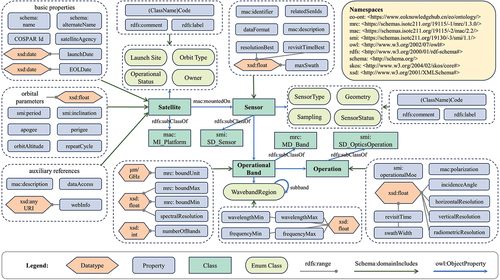
Figure 2. Integration of Earth observation satellite information from multiple databases.
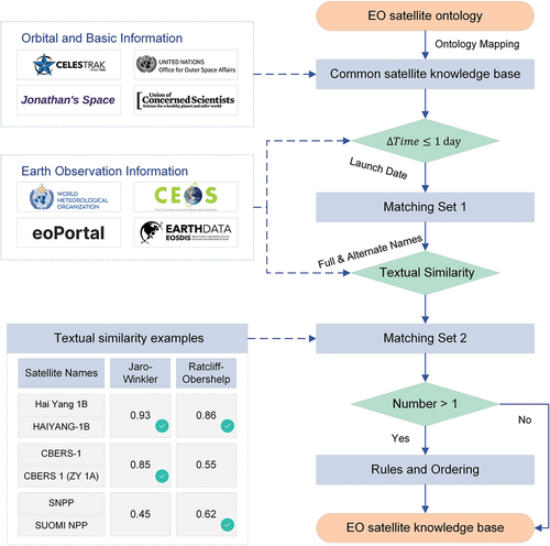
Figure 3. Extracting EO sensor information from web pages using large language models and regular expressions.
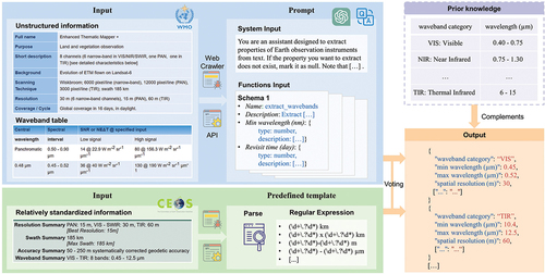
Figure 4. Comparative analysis of our EO satellite database and existing resources.
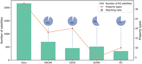
Figure 5. (a) Number of EO satellites launched annually. (b) Number of radar sensors of different resolutions launched annually. (c) Number of EO satellites operated by different countries or organizations. Data from international organizations such as ESA are listed only under themselves and are not duplicated in each member country.
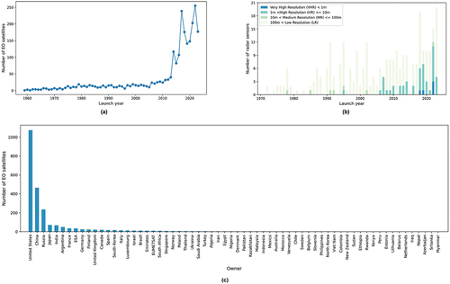
Figure 6. Analysis of the EO capabilities of the United States, China, Russia, and ESA. Line charts show the number of EO satellites launched over the years. Bar charts illustrate the operational status and mass of satellites in various orbit types. Pie charts demonstrate the distribution of wavebands among the sensors aboard these satellites.
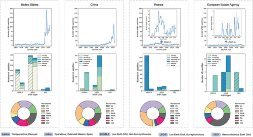
Figure 7. Satellite remote sensing resources that provide better spatial resolution than Landsat-8 in the thermal infrared spectrum.
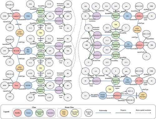
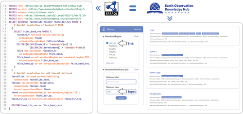
Figure 8. SPARQL query and online search to identify satellites and sensors with higher spatial resolution than Landsat-9 in the thermal infrared band.
Data availability statement
GEOSatDB was developed using widely adopted W3C technologies and standards, facilitating ease of extension and reuse. It is distributed under the Creative Commons Attribution-NonCommercial 4.0 International (CC BY-NC 4.0) license, permitting free use for non-commercial purposes with proper acknowledgement. The data are available for download in the standard RDF Turtle format at https://doi.org/10.57760/sciencedb.11805. GEOSatDB undergoes quarterly updates, involving the addition of new satellites and sensors, revisions based on expert feedback, and the implementation of additional enhancements. In addition, a user-friendly portal (http://www.geosatdb.cn) is being developed to ensure easy access to GEOSatDB.