
 ?Mathematical formulae have been encoded as MathML and are displayed in this HTML version using MathJax in order to improve their display. Uncheck the box to turn MathJax off. This feature requires Javascript. Click on a formula to zoom.
ABSTRACT
This study presents a multidimensional urban sprawl assessment in 15 Indonesian island cities using 17 indicators across densities, composition, and configuration dimensions. The analysis utilizes data from the Global Human Settlement Layer (GHSL). Larger-sized islands serving as provincial capitals or regional activity centers, governed by multidistrict jurisdictions, tend to be more sprawl. Island-level planning and governance are crucial for managing sprawl effectively. The study highlights the coexistence of multiple sprawl typologies within single-island cities and emphasizes the limitations of simplistic binary/linear sprawl assessments. The findings offer insights applicable beyond island contexts, bridging regional and urban units in multilevel settings.
1. Introduction
1.1. Urban sprawling on Island cities
Island cities are unique in that they exist at the intersection of two contrasting spatialities. On the one hand, island spatialities offer advantages such as well-defined territorial boundaries, strategic defense positions, and efficient transportation networks. However, they also present spatial constraints due to limited land availability, which tends to lead to compactness and hinder urban sprawl and dispersion. On the other hand, urban spatialities have self-agglomerating characteristics, resist boundaries, and benefit from room to grow. Some evidence suggests that cities surrounded by water can achieve greater density, as seen in major trading hubs and global cities (Grydehøj, Citation2015). Understanding which spatiality wins out over this tension depends on the type of island and the conditions present. A multidimensional morphology assessment of island cities is needed to measure empirically whether they exhibit sprawling or compact patterns.
Urban sprawl is a worldwide phenomenon characterized by low values in land use patterns such as density, continuity, concentration, clustering, centrality, nuclearity, mixed uses, and proximity (Galster et al., Citation2001) which result in a pattern of low development density, segregated land uses, lack of significant centres, and poor street accessibility (Ewing et al., Citation2002). Why is urban sprawling a critical issue on islands? Because of inherent vulnerabilities possessed by the island. As islands are geographically finite, bounded, discrete, and have limited less diverse resources (Baldacchino, Citation2004; Randall, Citation2021), urban sprawl can pose an even greater threat to their socio-spatial systems. This pattern of development can result in irreversible damage to local ecosystems, including the loss of valuable land resources, degradation of soil quality, obstructed water absorption, and altered microclimates, leading to increased car dependency, escalating the cost of per-person infrastructure, weakened sense of community and spatial segregation tendency. Furthermore, urban sprawling can also put pressure on the island’s natural and cultural heritage (Chorianopoulos et al., Citation2014; Tsilimigkas & Kizos, Citation2016; Kizos et al., Citation2017; Tsilimigkas et al., Citation2022). The sprawling phenomenon of island cities cases often associated with the near-shore islands that sprawl to the mainland and create expanded metropolises such as Abu Dhabi, Amsterdam, Lagos, Stockholm, Chongming, and Macau (Grydehøj, Citation2014, Citation2015a; Sheng et al., Citation2017; Baldacchino, Citation2020). However, in this paper, we aim to explore more non-typical cases to shed light on the image of urban sprawling in archipelagic regions that are neither near-shore nor high-sea (remote) islands.
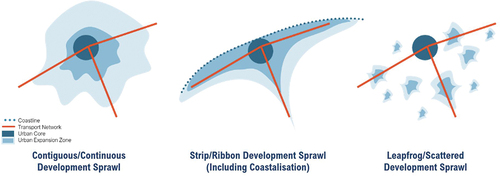
There are three urban sprawl typologies based on their morphology (see ): contiguous/continuous suburban sprawl, strip/ribbon sprawl, and leapfrogging/scattered development sprawl (Barnes et al., Citation2002; Pichler-Milanovic et al., Citation2007; Couch et al., Citation2007; Lagarias & Sayas, Citation2019). Contiguous/continuous suburban growth involves the gradual expansion of a city’s built-up area along its periphery in a contiguous and continuous manner. Strip/ribbon development is characterized by linear development expansion along major transportation corridors resulting in a ribbon-like development pattern. Leapfrog or scattered development involves the development of new urban areas beyond the existing built-up area of the city resulting in a scattered pattern of development that is not connected to the existing urban fabric. However, in the coastal and island cities cases, the linear-type urban sprawl not only expanded along major transportation corridors but also along the coastal zone also known as coastalization (Tsilimigkas et al., Citation2022; Lagarias & Stratigea, Citation2023).
Figure 1. Typologies of Urban Sprawl.
In Indonesia, urban sprawl hinders prosperity-enhancing agglomeration and knowledge spillovers by creating residential segregation, limiting access to services and job opportunities, and exacerbating inequality. This is caused by demand-side pressure, deficient land-use management, and weak institutional coordination that pushes people towards peripheral locations. Subsidized single-family housing development perpetuates urban sprawl by promoting low-density growth and increasing land and infrastructure costs (Roberts et al., Citation2020). While the majority of research on urban sprawl in Indonesia has focused on Java island, particularly in and around large metropolitan areas (Firman, Citation2017; Firman & Fahmi, Citation2017; Mardiansjah et al., Citation2021; Pratama et al., Citation2021) studies outside Java island are still limited (Ahyuni & Nur, Citation2020) and mostly consist of single case studies (Christiawan, Citation2019; Surya et al., Citation2021) or macro-level analyses (Olivia et al., Citation2018; Civelli et al., Citation2020).
1.2. When all cities are on Islands, what are island cities?
All cities in archipelagic countries such as Indonesia are located on islands, as there are no cities situated on any continental mainland. This may be one of the reasons why planning for island cities has been somewhat overlooked, as it is often regarded as regular city planning. Island cities can be categorized based on their position and location (Grydehøj, Citation2014; Grydehøj, et al., Citation2015), either as densely urbanized small islands and archipelagos or major population centers of large islands or archipelagos. However, the threshold for the small or large size is not clearly defined. Island cities can also be categorized based on the historical development process, pathway, and trajectories (Tutt, Citation2014). They may refer to:
near-shore islands consumed by a city that has spread far beyond its original insular limits;
culturally and historically constrained cities that are often stagnant unless reimagined, or
modest proto-cities that are limited in their outreach to expand beyond their present boundaries, except in servicing their own immediate insular hinterland.
As a result, both cities on islands and islands that are urbanized theoretically comply with the definition of Island Cities. However, in the Indonesian context, the five largest islands (New Guinea, Borneo, Sumatra, Sulawesi, and Java) are often excluded and not considered ‘islands,’ as they are large landmass areas that lack insularity characteristics (Maulana & Benita, Citation2017). In this study, Timor Island, the sixth largest island, is also excluded.
Defining cities in Indonesia can also be complex, as national territories are divided into provinces and autonomous regions, each of which is divided into two types of Local Administrative Units (LAUs): municipalities (kota) and districts/regencies (kabupaten). Below kota/kabupaten there are more two levels of LAUs, sub-districts (kecamatan), and villages/urban communities (desa/kelurahan). Cities are typically understood as urban areas encompassed by municipal boundaries, while non-statutory towns or extended urban regions fall under the jurisdiction of regencies (Mardiansjah et al., Citation2021). Therefore, in the present paper island cities are defined as:
cities that are located on a smaller island outside six major Indonesian islands
the urbanized smaller island outside six major Indonesian islands that has one or more cities
1.3. Objectives and scope of the study
The present study aims to analyze and characterize urban sprawl patterns in Indonesian island cities using multidimensional assessment. The novelty of this study lies in its focus on islands, with multi-comparative case studies across multiple spatial scales, including insular and city levels. This approach addresses a research gap recently identified in the literature (Zhang et al., Citation2023) and contributes to a better understanding of urbanization patterns in island cities.
2. Material and methods
2.1. How to measure sprawl? Methodological review and proposed framework
After understanding what is urban sprawl and why its impacts are more significant on island regions, we need to know how to measure it. Researchers from developed and developing countries have attempted to understand and quantify the extent of sprawl, employing various methodologies. In , we present a summary of these methodologies sourced from existing literature and case studies.
Table 1. Various methodology to measure urban sprawl.
The aforementioned methods are a few examples among many others used to measure urban sprawl, including Entropy (Yeh & Li, Citation2001; Bhatta et al., Citation2010), Moran’s I, Gini Index and Geary coefficients (Tsai, Citation2005). However, their interpretation is considered as not straightforward (Steurer & Bayr, Citation2020) and are often dependent on the size, shape, and number of regions due to scale problem or modifiable areal unit problem (Bhatta et al., Citation2010). Thus, in this paper, we propose a simple yet comprehensive framework that encompasses three dimensions to quantify and characterize the phenomenon of sprawl by combining densities, land use composition, and configuration of landscape metrics (McGarigal et al., Citation2023). To ensure comparability between metrics with different scales, standardization is applied using EquationEquation (1)(1)
(1) , where
is the standardized value,
is an observed value,
is mean, and
is a standard deviation.
This standardization process allows for a meaningful assessment of the relationship between the characteristics described in each dimension and the phenomenon of urban sprawl. The standardized values of each metric are then correlated with the Urban Sprawl Index (USI), as previously established in studies by Gao et al. (Citation2016) and Horn and van Eeden (Citation2018). This correlation analysis serves to examine the extent to which the identified characteristics are associated with the sprawling phenomenon, providing valuable insights into the relationship between various dimensions and urban sprawl.
illustrates the dimensions, metrics of the proposed framework, and hypothetical direction of the relationship with sprawl.
Figure 2. Dimensions and metrics of multidimensional sprawl indicators.
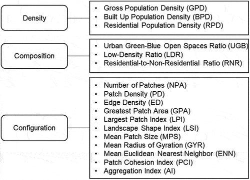
Densities dimension is measured using three metrics: Gross Population Density (GPD), Built-up Population Density (BPD), and Residential Population Density (RPD). GPD indicates the total population per land area (total island area), BPD measures population density within built-up areas, encompassing residential and non-residential land uses, while RPD focuses solely on residential built-up area density. These metrics help differentiate urbanization intensity by accounting for potential biases such as variations in island size and built-up areas, which may include extensive industrial, commercial, or port areas. They offer insights into density levels and urban sprawl where low values indicate low-density sprawl, while high values signify high-density development.
Composition dimension is assessed using three metrics: Urban Green Blue Open Spaces Ratio (UGB), Low-Density Ratio (LDR), and Residential to Non-Residential Ratio (RNR). Sprawl is often characterized by a low UGB ratio, a high LDR ratio, and a high RNR ratio. In other words, sprawling cities tend to have less green and blue open spaces, a greater proportion of low-density areas, and a lower diversity of land use types, with a predominance of residential land use.
Configuration dimension is evaluated using ten spatial metrics: Number of Patches (NPA), Patch Density (PD), Edge Density (ED), Greatest Patch Area (GPA), Largest Patch Index (LPI), Landscape Shape Index (LSI), Mean Patch Size (MPS), Mean Radius of Gyration (GYR), Mean Euclidean Nearest Neighbor (ENN), Patch Cohesion Index (PCI), and Aggregation Index (AI). NPA, PD, and ED assess the level of fragmentation within the landscape, while GPA and LPI measure the dominance of the largest patches. LSI quantifies the complexity of landscape shape, and MPS represents the average size of patches. GYR calculates the average extent of patches, while ENN evaluates the degree of patch isolation. PCI reflects the physical connectedness of patches, and AI assesses the overall aggregation or disaggregation of the landscape (McGarigal et al., Citation2023).
2.2. Context and case studies
Indonesia is a vast archipelagic country with a large number of islands; nonetheless, the exact number of islands remains a subject of debate. Law No. 6/1996 concerning Indonesian waters lists 17,508 islands, but this number has since been reduced to 17,504 following the loss of sovereignty over certain islands. Recently, the National Gazette registered 16,771 islands (KKP, Citation2022), while Landsat satellite images indicate 13,558 islands (Andréfouët et al., Citation2022). The newly published Global Island Explorer dataset, on the other hand, suggests 10,382 islands (Sayre, Citation2023). Despite this ambiguity, one thing is clear: Indonesia’s unique geography poses significant challenges and opportunities for spatial planning. Hence, in addition to the general hierarchical national-regional-local spatial planning, Indonesia also has an island/archipelago spatial plan (GoI, Citation2007, Citation2022; ATR/BPN, Citation2023), reflecting the complexity of managing a country spread across thousands of islands. The positioning of the plan within Indonesia’s spatial planning system is illustrated in .
Figure 3. Positioning of Island/Archipelago Spatial Plan in Indonesia’s Planning System.
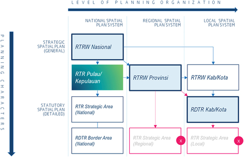
In an ideal scenario, a macro strategic spatial plan formulated at the national level should be translated into corresponding plans at the regional scale, such as the RTR Pulau/Kepulauan (Island/Archipelago Spatial Plan), and RTRW Provinsi (Provincial Spatial Plan). These regional plans, in turn, guide the formulation of local statutory spatial plans, such as the RDTR Kabupaten/Kota (City/District Detailed Spatial Plan). However, due to decentralization and local autonomy, municipalities and regencies have the authority to develop their own strategic spatial plans, which may differ in terms of detail compared to provincial plans. Recent spatial planning reforms in 2021 have resulted in the abolition of local government’s rights to create statutory spatial plans for strategic area development. Under the new law, only the national government is authorized to formulate statutory spatial plans for strategic area development, aligning them with national priorities and ensuring they possess national significance and impacts (GoI, Citation2021).
Recognizing that rapid and unplanned urbanization has led to sprawl development, Indonesia has acknowledged the importance of addressing this issue. In a recent voluntary national review on the implementation of the New Urban Agenda, the Indonesian government has committed to preserving and promoting the ecological and social functions of land, promoting sustainable land use, and implementing strategies to contain urban sprawl. To prevent sprawl, the government encourages spatial development strategies that prioritize urban renewal, urban regeneration, infill development, and planned urban extensions. These strategies include the provision of accessible and well-connected infrastructure and services, sustainable population densities, and compact urban design (MoPWH, Citation2021).
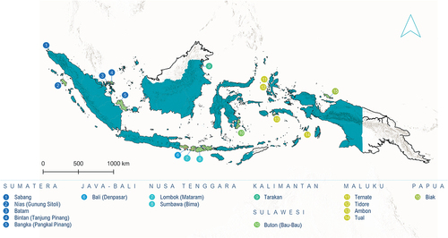
However, existing efforts to measure sprawl using indicators such as SDG 11.3.1 and NUA Indicator 15, which assess the ratio of land consumption rate to population growth rate, are often conducted within city administrative boundaries (MoPWH, Citation2021). This approach can lead to misrepresentation as it fails to capture urban expansion occurring outside these boundaries such as new scattered settlements or leapfrogging development (Frenkel & Ashkenazi, Citation2008), thereby underestimating the true extent of sprawl. In the context of island cities, the geographical discontinuity between land and sea provides effective spatial boundaries for examining the full extent of urban sprawl. Therefore, this paper proposes to examine multiple case studies in 15 island cities representing each island region in Indonesia. The selection of these case study areas is based on the proposed definition and specific criteria outlined in the previous section to ensure the representativeness of each island region. The selected case study areas are provided in .
Table 2. Case study areas.
In order to ensure comprehensive coverage and representation of different island regions, certain inclusions and limitations have been applied in this research. Specifically:
For municipalities that encompass multiple islands and islets, the focus will be on the main island. This applies to cases such as Sabang, Batam, Ternate, Tidore Kepulauan, and Tual, where the municipality extends over two or more islands. The primary island within these municipalities will be examined as the main focus of this study.
For larger islands that include a city and multiple non-statutory towns, all urban areas on the island will be analyzed. This approach applies to island cities with multiple districts (Nias, Bintan, Bangka, Bali, Lombok, Sumbawa, Buton, Ambon), ensuring that the analysis encompasses the entire island rather than focusing solely on major cities.
In cases where smaller islands within a larger island region lack a local government with municipality status, the most populous island within that region (in this instance, Biak) will be chosen for representation in the study. This approach ensures that the research maintains representativeness by including the most significant island within the region.
Out of the 15 island cities, five of them serve as provincial capitals: Bintan/Tanjungpinang (capital of Riau Archipelago Province), Bangka/Pangkalpinang (capital of Bangka Belitung Archipelago Province), Bali/Denpasar (capital of Bali Province), Lombok/Mataram (capital of West Nusa Tenggara Province), and Ambon (capital of Maluku Province). It is worth noting that although the capital of North Maluku Province is within the Tidore Kepulauan municipality, it is located in Sofifi on Halmahera Island rather than on Tidore Island. Additionally, two island cities, We/Sabang and Batam, hold the status of Free Trade Zone and Free Ports. Tarakan and Ternate, on the other hand, are the most populous urban settlements within their respective provinces and serve as national activity centres (PKN). The remaining island cities serve as regional activity centres (PKW), playing important roles in facilitating regional activities and development. The specific locations of the case study areas are illustrated in , providing detailed geographic information for reference.
Figure 4. Case study areas: 15 Island Cities/Towns.
2.3. Data and working scales
This study utilizes two datasets: Global Islands from the US Geological Survey and Global Human Settlement Layer from the European Commission. Global Islands is a new global shoreline vector (GSV) with a 30-meter spatial resolution that was created using Landsat satellite imagery from 2014. The resulting vector was divided into four island size categories, including Continental Mainland, Big Islands (greater than 1 km2), Small Islands (between 1 km2 and 0.0036 km2), and Very Small Islands (less than 0.0036 km2). The vector also had polygon topology applied to it for accuracy (Sayre et al., Citation2019; Sayre, Citation2023). Despite having fewer islands (10,382 islands) than the official count in the national gazette 2022 (16,771 islands), this publicly available data is still useful due to its topological information.
Global Human Settlement Layer, on the other hand, is an open and free tool for assessing human presence on the planet. The latest version, GHSP2023, represents a significant advancement in accuracy and reliability. Notably, this version addresses and rectifies anomalies in the multi-temporal modelling mechanism, resulting in more precise information (European Commission, Citation2023). This recalibration enables more precise calculations of built-up surfaces and populations over multiple periods, offering deeper insights into the dynamics of urban sprawl. presents the data, sources, data types, and resolution used in this study:
Table 3. Data, sources and types.
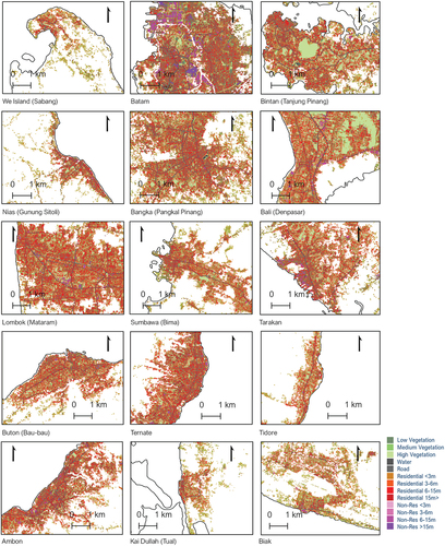
On the insular level, the minimum working scale employed is 1:100,000 although this may vary depending on the size of the island. At this level, the study aims to observe general morphological patterns of settlement areas across the island (see ). For the city level, a working scale of 1:10,000 is adopted to examine more detailed characteristics of the settlement. This includes analyzing the density of urban fabrics, and functional components such as urban green and blue spaces, and evaluating the proportion of residential and non-residential areas. In this study, the threshold for low and high-density settlements is based on the 15-meter height assumption, reflecting buildings ranging from 3 to 5 floors in height which are considered an acceptable range for low to medium-density settlements but not as high-density urban fabrics. The complete overview of the morphological settlement zone categorization is provided in .
Figure 5. Distribution of settlement areas in 15 island cities/Towns.
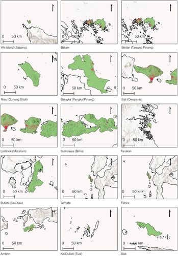
Table 4. Classification of morphological settlement zone grouped into categories.
3. Results
3.1. Densities
According to Gross Population Density (GPD), the five densest islands are Batam, Ternate, Tarakan, Bali, and Ambon, with a population density of more than 790 people per square kilometer. Among them, Batam, Tarakan, and Ternate are single municipalities and serve as the main economic centers (PKN) in their respective provinces, while Bali and Ambon are multidistrict island cities, acting as provincial centers for Bali and Maluku. On the other hand, the five least dense islands, with a population density of less than 200 people per square kilometer, are Biak, Buton, Sumbawa, Bangka, and Nias, all of which are multidistrict island cities. It is worth noting that GPD includes all land areas on the island, including uninhabitable regions such as forests, open spaces, and mountainous areas.
When comparing the results of Built-up Population Density (BPD) and Residential Population Density (RPD), the rankings relatively similar. The islands with the highest population density per built-up area are Ambon, Nias, Batam, Tarakan, and Ternate, while the islands with the highest population density per residential area are Batam, Ambon, Nias, Tarakan, and Ternate. Interestingly, Nias, which appeared among the least dense islands based on GPD, emerges as the densest island city according to BPD and RPD. Conversely, Sabang, Bangka, Bintan, Bali, and Kai Dullah have the lowest population density per built-up area, and Sabang, Bangka, Bali, Tidore, and Bintan have the lowest population density per residential area.
These density metrics in provide initial insights into the sprawling patterns of island cities. Islands with high GPD and RPD, such as Batam and Ambon, are already relatively dense. Conversely, islands like Bangka have low densities across all metrics, indicating a more sprawling development pattern. Moreover, the case of Bali stands out. Despite having a high GPD, suggesting relatively high population density, the low BPD and RPD indicate a tendency toward sprawling development patterns. Furthermore, the case of Nias presents an interesting contrast. Despite its low GPD, the island exhibits a compact footprint as evidenced by its high BPD and RPD. This might indicate efficient land use and suggests that Nias does not consume excessive land area, despite its lower population density. However, it is important to note that density measurements alone do not provide a comprehensive understanding of urban sprawl. To capture the complete image of urban sprawling, it is necessary to examine these density metrics in conjunction with other indicators.
Table 5. Density dimension calculation summary.
3.2. Composition
Considering the composition dimension, it is notable that certain island cities exhibit distinct characteristics that are relevant to urban sprawl. Firstly, when examining the urban green spaces ratio within the settlement area (UGB), island cities like Batam, Kai Dullah, Bintan, Tarakan, and Bangka have the highest proportions. This indicates that a significant portion of their settlement areas is dedicated to green spaces. On the other hand, island cities such as Tidore, Buton, Ternate, Nias, and Ambon have the least proportion of urban green spaces within their settlement areas. This indicates a potential lack of green spaces and a higher degree of built-up development.
Furthermore, considering the ratio of low-density urban fabrics within the settlement area (LDR), island cities like Tidore, Lombok, Buton, Nias, and Sumbawa are primarily characterized by a dominance of low-density urban fabric. This means that a significant portion of their built-up areas consists of low-density developments. Such patterns can be indicative of urban sprawl, as low-density urban fabric often requires larger land areas per unit of population. Conversely, island cities such as Batam, Bintan, Biak, Ternate, and Kai Dullah have the least proportion of low-density urban fabric. This suggests a more compact and higher-density urban form, which can be indicative of better land use efficiency and a reduced tendency for urban sprawl. Lastly, analyzing the residential-to-non-residential ratio (RNR) provides insights into the mix of land uses within the island cities. Island cities like Nias, Bangka, Sabang, Lombok, and Kai Dullah exhibit a high level of homogeneity in terms of land uses, indicating a predominance of residential areas and a potential lack of diverse non-residential activities.
In contrast, island cities such as Batam, Tarakan, Ternate, Bintan, and Ambon demonstrate a higher level of land use mix. These cities have a more diverse distribution of residential and non-residential areas, suggesting a greater integration of living spaces with commercial, industrial, and institutional activities. Island cities with a high proportion of urban green spaces (high UGB) and a lower proportion of low-density urban fabric (low LDR) indicate more compact and sustainable development patterns that are less prone to sprawl. Additionally, island cities with a higher degree of land use mix (low RNR) suggest a more integrated and diverse urban fabric. presents a detailed summary of calculations, and provides an overview of the composition dimension in 15 island cities.
Table 6. Composition dimension calculation summary.
Figure 6. Settlement Land Uses Characteristics in 15 Island Cities/Towns.
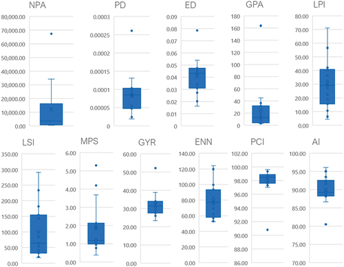
3.3. Configuration
In terms of configuration, several island cities exhibit fragmented patterns with a high number of patches (NPA), including Bali, Lombok, Bangka, Nias, and Sumbawa. Patch Density (PD) and Edge Density (ED) also indicate high values for Nias, Biak, Bintan, Bangka, and Buton, suggesting higher levels of fragmentation in larger islands. The dominance of urban cores can be seen through the Greatest Patch Area (GPA), with Bali, Lombok, Bangka, Batam, and Bintan having prominent urban patches larger than 20 sqkm. However, the Largest Patch Index (LPI) provides a more comprehensive understanding of dominance, showing Ternate, Tarakan, Tual, Tidore, and Sabang as islands with the greatest LPI values, indicating that a significant portion of the urban landscape is concentrated within the largest patch.
Landscape Shape Index (LSI) reveals high complexity in the urban morphology of multidistrict islands like Bali, Lombok, Bangka, Nias, and Sumbawa, while single-municipality islands like Ternate, Tual, Tidore, Sabang, and Tarakan exhibit simpler geometric configurations. Mean Patch Size (MPS) indicates that Nias, Biak, Bintan, Bangka, and Buton have smaller patch sizes, indicating a scattered or leapfrog pattern of sprawl development. On the other hand, islands such as Ternate, Batam, Tidore, Tual, and Ambon have relatively larger patch sizes, suggesting a more compact form. The Mean Radius of Gyration (GYR) highlights Tidore as having the largest extent of elongated patches, potentially indicating linear or strip sprawl development, while Nias exhibits smaller GYR values, suggestive of scattered or leapfrog sprawl development.
Euclidean Nearest Neighbor (ENN) reveals that Bali, Batam, Ambon, Tarakan, and Sabang have closer distances between neighboring patches on average, while Sumbawa, Bangka, Buton, Nias, and Tidore exhibit greater distances, hinting at isolated urban patches resulting from scattered or leapfrogged sprawl. The Patch Cohesion Index (PCI) and Aggregation Index (AI) provide insights into the degree of subdivision and physical connectivity. Nias demonstrates the lowest scores for both PCI and AI, indicating a tendency towards disaggregation, while Ternate exhibits the highest scores, suggesting a more connected and aggregated urban landscape. Detailed information can be found in and .
Table 7. Configuration dimension calculation summary.
Figure 7. Configuration Dimension.
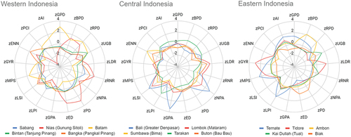
3.4. Image of sprawl: multidimensional approach
The multidimensional analysis of density, internal land-use composition, and spatial morphology metrics allows us to compare the performance of each city and metric, providing valuable insights into the nature of sprawl. For instance, highlights the characteristics of Nias, which exhibits high levels of low-density development, homogeneity, fragmentation, and a scattered and disconnected urban landscape. Bali, on the other hand, demonstrates a combination of sprawl patterns. It has the largest greatest patch area, indicating continuous or contagious sprawl, while also displaying a high number of urban patches and geometric complexity, indicating fragmentation or scattered sprawl development at the insular level. Tidore presents a different form of sprawl, characterized by low population density, a significant proportion of low-density urban fabrics, and a high radius of gyration, indicating linear, ribbon, or strip sprawl development, possibly associated with coastalization. Larger multidistrict island cities like Nias, Bangka, Sumbawa, and Buton exhibit dispersed urban landscapes with greater distances between patches.
Figure 8. Radar chart multidimensional sprawl assessment.
Upon comparing the results with the Urban Sprawl Index (USI), we find that based on USI methodology only three island cities are considered to have urban sprawl issues: Bintan, Nias, and Tual. This determination is based on the USI value being greater than 0, indicating that the annual growth of built-up expansion has surpassed the annual population growth. Particularly noteworthy is the case of Tual, which exhibits a declining population trend but positive growth in built-up areas, as indicated in . Conversely, island cities with a USI value less than 0 are considered to be on track in terms of sprawl management. In this regard, Batam, Tarakan, and Ambon emerge as the most compact and efficient in land use, with more than 3% growth differences or approximately every 1% built-up area expansion that can accommodate 4–5% population growth.
Table 8. Urban sprawl index calculation summary.
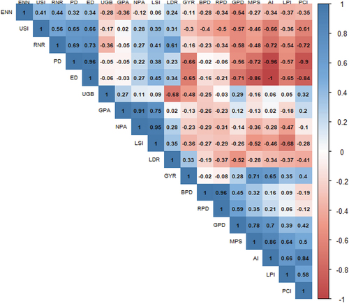
According to the correlation analysis (see ), conducted after excluding Tual as an outlier case, significant associations were observed between the Urban Sprawl Index (USI) and various metrics. The USI exhibited positive correlations with the residential-to-non-residential area ratio, patch density, edge density, landscape shape index, low-density ratio, and the number of patches. Notably, the correlation with the Greatest Patch Area appeared to be relatively neutral. Conversely, negative correlations were found between the USI and the aggregation index, patch cohesion index, gross population density, residential population density, built-up area density, mean patch size, largest patch index, mean radius of gyration, and urban green-blue ratio. Therefore, based on the observed correlations and their significance, the selected metrics utilized for the multidimensional assessment can be considered valid and robust for examining the complex phenomenon of urban sprawl.
Figure 9. Correlation Matrix.
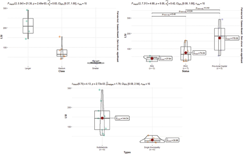
We conducted Welch’s ANOVA Test to examine if various categories of island cities exhibit similar sprawl patterns, as it accommodates unequal variances across groups. The analysis considered island area size class (Larger, Medium, Smaller), status (PKN, PKW, Provincial Capital), and type (Multidistrict or Single Municipality –see ). Across 17 indicators, LSI (Landscape Shape Index) showed significant differences with a 95% (for status) to 99% (for class and type) confidence level. Smaller or Medium Island Cities with National Activity Centre (PKN) status and governed under a single municipal jurisdiction tend to display less complex urban morphology (such as Tarakan, Ternate, and Batam), indicating compactness. Conversely, Larger Island Cities hosting provincial capitals and comprising multiple districts exhibit more complex morphology, suggestive of sprawl (such as Bali/Greater Denpasar, Bangka/Pangkal Pinang, Bintan/Tanjung Pinang, Lombok/Mataram). However, from a pairwise test using Games-Howell posthoc analysis, only categorization by island size class showed moderately significant results at a 90% confidence level with a Holm-adjusted p-value of 0.06. Calculation results are provided in , and illustrative figures in .
Table 9. Welch’s ANOVA test calculation summary.
Figure 10. Post-Hoc Analysis.
4. Discussion
The multidimensional approach employed in this study moves beyond simplistic binary concepts of ‘sprawl or not sprawl’, or linear continuums of more or less sprawl. The incorporation of three dimensions: configuration or spatial metrics, land-use composition, and density measurement, offer a comprehensive and detailed depiction of the sprawl phenomenon. Previous research has acknowledged the importance of considering configuration and spatial metrics (Lagarias & Stratigea, Citation2021) as well as land-use composition (Frenkel & Ashkenazi, Citation2008; Arribas-Bel et al., Citation2011; Tsilimigkas et al., Citation2016) in understanding urban sprawl. Additionally, density measurement has been recognized as a crucial factor in sprawl analysis (Clark, Citation1958; Bruegmann, Citation2005). By integrating these three dimensions, this study captures a more complete picture of sprawl, considering both the level of population density, the distribution of land uses, and the physical arrangement of urban areas. While our multidimensional approach offers a comprehensive view of urban sprawl, it does not fully capture the dynamics and pace of sprawl over time. We also recognize the importance of streamlining and simplifying some indicators, particularly those that may appear redundant, complex, or not straightforward in interpretation.
The choice of islands as a case study provides distinct advantages in capturing both internal urban phenomena and regional urban patterns at the insular level. Island cities possess unique characteristics that differentiate them from mainland cities, such as limited land availability and clear spatial boundaries due to land-sea geographical discontinuity. This is demonstrated in our findings, where Tual, Nias, and Bintan are the only three islands with positive Urban Sprawl Index (USI) scores. However, other islands also exhibit different indications of sprawl, which are overlooked if we only use USI. In addition, the insularity effects of smallness and limited space on the island show that islands that have smaller area size and relatively growing populations such as Tarakan, Ambon, and Batam tend to indicate a more contiguous sprawl pattern than islands that are larger and slower population growth such as Nias and Lombok are more dispersed. These findings are in line with findings in European cases (EEA, Citation2016) which highlighted that sprawl can occur in regions with growing, stable, or declining populations, especially in coastal and island regions.
The findings of the study also reveal that sprawl typologies are not mutually exclusive, and an island city can exhibit multiple sprawl typologies simultaneously. For example, in the cases of Bali or Lombok (both are provincial capitals on relatively larger islands), the primary urban zones demonstrate continuous and contiguous sprawl development, while the entire island displays scattered and leapfrogged sprawl development. On multidistrict medium-larger islands like Nias, Buton, Bangka, and Sumbawa, scattered and leapfrogged sprawl development prevails, characterized by high patch isolation and low physical connectivity. Smaller, single-municipal, and National Activity Centre (PKN) island cities, such as Batam, Tarakan, and Ternate, tend to exhibit more compact urban forms. However, even smaller islands with Regional Activity Centre (PKW) status may also show signs of coastalization or linear/strip/ribbon sprawl development patterns with relatively low-density and homogenous urban fabrics, as observed in Tidore. The presence of Free Trade Zone/Free Port status does not consistently define distinctive urban sprawl patterns. For instance, Sabang is associated with low density and homogeneous land use characteristics, with compact and dominant core area (high largest patch index) akin to other island cities categorized as regional activity centers (PKW) on smaller islands. Conversely, Batam exhibits a denser and heterogeneous land use, with relatively large core areas (high greatest patch area) resembling other cities with national activity center (PKN) status.
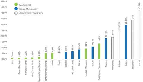
Understanding the specificities of each type of sprawl identified in the study enables the development of targeted strategies and solutions to address the challenges associated with urban sprawl. Comparing Indonesian island cities with their counterparts in Asia (see ) reveals that only Batam and Ternate exhibit a considerably similar level of urbanization to cities like Hong Kong and Bahrain, albeit far below that of Singapore or Macau (OECD, Citation2014). Island cities governed by a single municipal unit can focus on tackling sprawl by addressing specific indicators that need improvement. For instance, Sabang, Tual, and Tidore could prioritize densification and diversification of land uses, while Tarakan, Ternate, and Batam could focus on protecting, preserving, and expanding urban green spaces within densely built-up areas, and controlling urban expansion through carefully planned measures.
Figure 11. Urban built-up share comparison with Asian Island Cities.
Addressing sprawl in multidistrict island cities necessitates regional island governance-level interventions to overcome fragmented decision-making resulting from decentralization and diverse policy directions. An ideal example is Bali and Greater Denpasar, where a single provincial jurisdiction governs the entire island of Bali, facilitating coordinated planning and policy implementation at the island level, while urban core planning is managed through Metropolitan Planning involving relevant municipalities and districts. However, in other cases, fragmented governance structures with no insular-level authority exist, leading to challenges in sprawl management. These complexities highlight the need for a middle-tier planning and governance at the island level to effectively address sprawl issues. For instance, some island cities could benefit from land use diversification strategies, such as incorporating green spaces within densely built-up areas (e.g. Ambon, Buton, Sumbawa) or increasing non-residential land use (e.g. Bangka). In other cases, a comprehensive approach combining densification and diversification may be appropriate (e.g. Lombok, Nias, Tidore), or even spatial rearrangement strategies aimed at connecting dispersed urban patches to established compact and connected urban areas.
However, implementing a spatial rearrangement strategy poses challenges, as it can have irreversible impacts on the socio-spatial system. Once spatial rearrangement occurs, it becomes irreversible (Tsilimigkas et al., Citation2022; Yang et al., Citation2023) and is considered a remorseless phenomenon (Salingaros, Citation2006). To address this challenge, strengthening not only integrated planning regulation but also developing price mechanisms to prevent urban sprawl is imperative, as regulatory effort through planning for urban containment alone will not be sufficient as reported in the case of Portland, Oregon (Giovannoni, Citation2021). By adopting a comprehensive approach that addresses both spatial rearrangement and regulatory measures, island cities can better mitigate the adverse effects of sprawl and promote sustainable urban development.
5. Conclusion
In conclusion, the study demonstrates that island spatialities favoring dense, diverse, and compact configurations tend to prevail in smaller-sized islands with well-developed economies, hosting national activity centers (PKN), and governed by a single municipal unit. Conversely, urban spatialities characterized by self-agglomeration, boundary resistance, and expansiveness are predominant in larger-sized islands, particularly those serving as provincial capitals or developing as regional activity centers (PKW), and governed by multidistrict or municipal administrations.
Furthermore, this study highlights the limitations of simplistic binary or linear assessments of sprawl, such as categorizing areas as either sprawl or non-sprawl or evaluating them based on degrees of sprawl. By adopting a multidimensional approach, we recognize that sprawl manifests in various forms and intensities, each requiring tailored actions for effective resolution. It is not sufficient to solely identify the presence or extent of sprawl; we must also comprehend the specific attributes and dynamics associated with different types of sprawls. This nuanced understanding allows us to develop context-specific interventions that address the root causes and challenges of sprawl in a more targeted and effective manner.
Middle-tier planning and governance at the island (regional) level are imperative to ensure that island planning transcends its role as a mere macro strategic spatial plan between national and provincial levels. Instead, it should facilitate coordination between provinces and local municipalities/districts coexisting on an island. By enhancing planning regulation, implementing effective financing and price mechanisms, and coordinating development efforts, effective sprawl management on island cities can be achieved.
The diversity of cases explored, encompassing small and medium-sized islands with varying circumstances – ranging from well-developed, densely populated cities to relatively underdeveloped, sparsely populated towns, as well as islands located near the shore and those more remotely situated – provides a wealth of examples that enrich our understanding of island cities, especially in the developing world. This research not only contributes to our knowledge of urban sprawl but also offers valuable insights into the unique complexities and opportunities presented by island cities across the globe.
The multidimensional assessment presented in this study holds promise for application beyond insular contexts, extending its utility to non-insular cities. Here, ‘insular’ can be conceptualized as a region, suggesting its potential applicability in analyzing sprawl within metropolitan regions and other multilevel contexts bridging any regional level and urban units. As such, the findings and methodologies showcased in this study offer valuable insights for understanding and managing urban sprawl across diverse geographical settings and administrative scales.
Author contributions
Luthfi Iqbal: Writing – original draft, Conceptualization, Visualization, Data curation, Methodology, Investigation, Formal Analysis. Georgios Tsilimigkas: Supervision, Writing – review & editing, Conceptualization, Methodology, Validation, Resources. Thanasis Kizos: Supervision, Writing – review & editing, Validation, Conceptualization, Resources.
Graphical Abstract.jpg
Download JPEG Image (952.8 KB)
Author Bio and Title Page.docx
Download MS Word (28.3 KB)Disclosure statement
No potential conflict of interest was reported by the author(s).
Supplementary material
Supplemental data for this article can be accessed online at https://doi.org/10.1080/02697459.2024.2342756
Additional information
Funding
References
- Ahyuni, & Nur, H. (2020) Patterns of built-up area change in small cities of West Sumatra Province - Indonesia, International Journal of GEOMATE, 18(65), pp. 156–163. doi:10.21660/2020.65.ICGEO11
- Andréfouët, S., Paul, M., & Farhan, A. R. (2022) Indonesia’s 13558 islands: A new census from space and a first step towards a one map for small islands policy, Marine Policy, 135, pp. 104848. doi:10.1016/j.marpol.2021.104848
- Arribas-Bel, D., Nijkamp, P., & Scholten, H. (2011) Multidimensional urban sprawl in Europe: A self-organizing map approach, Computers, Environment, and Urban Systems, 35(4), pp. 263–275. doi:10.1016/j.compenvurbsys.2010.10.002
- ATR/BPN. (2023) Island/Archipelago Spatial Plan. [Online] Available at https://tataruang.atrbpn.go.id/sitarunas/rtrpulau
- Baldacchino, G. (2004) The coming of age of island studies, Tijdschrift voor Economische en Sociale Geografie, 95(3), pp. 272–283. doi:10.1111/j.1467-9663.2004.00307.x
- Baldacchino, G. (2020) How far can one go? How distance matters in island development, Island Studies Journal, 15(1), pp. 25–42. doi:10.24043/isj.70
- Barnes, K. B., Morgan, J. M., Roberge, M. C., & Lowe, S. (2002) Sprawl Development: Its Pattern, Consequences, and Measurement, Baltimore, Maryland: Geospatial Research and Education Laboratory, Department of Geography and Environmental Planning, Towson University.
- Bhatta, B., Saraswati, S., & Bandyopadhyay, D. (2010) Urban sprawl measurement from remote sensing data, Applied Geography, 30(4), pp. 731–740. doi:10.1016/j.apgeog.2010.02.002
- Bruegmann, R. (2005) Sprawl: A Compact History, (Chicago: The University of Chicago Press).
- Chettry, V. (2022) Geospatial measurement of urban sprawl using multi-temporal datasets from 1991 to 2021: Case studies of four Indian medium-sized cities, Environmental Monitoring and Assessment, 194(860). doi:10.1007/s10661-022-10542-6
- Chorianopoulos, I., Tsilimigkas, G., Koukoulas, S., & Balatsos, T. (2014) The shift to competitiveness and a new phase of sprawl in the Mediterranean city: Enterprises guiding growth in Messoghia – Athens, Cities, 39, pp. 133–143. doi:10.1016/j.cities.2014.03.005
- Christiawan, P. I. (2019) Tipe Urban Sprawl dan Eksistensi Pertanian di Wilayah Pinggiran Kota Denpasar, Jurnal Wilayah Dan Lingkungan, 7(2), pp. 79–89. doi:10.14710/jwl.7.2.79-89
- Civelli, A., Gaduh, A., Rothenberg, A. D., & Wang, Y. (2020) Urban Sprawl and Social Capital: Evidence from Indonesian Cities, Cambridge, MA: National Bureau of Economic Research.
- Clark, C. (1958) Transport - maker and breaker of cities, The Town Planning Review, 28(4), pp. 237–250. doi:10.3828/tpr.28.4.kun370rn6pg882g3
- Couch, C., Leontidou, L., & Arnstberg, K.-O. (2007) Introduction: Definitions, theories and methods of comparative analysis, in: C. Couch, L. Leontidou, & G. Petschel-Held (Eds) Urban Sprawl in Europe: Landscapes, Land-Use Change and Policy, p. 4 (s.l: Blackwell Publishing).
- EEA. (2016) Urban sprawl in Europe Joint EEA-FOEN report, Luxembourg: European Environment Agency.
- European Commission. (2023) GHSL Data Package 2023, Luxembourg: Publication Office of the European Union.
- Ewing, R., Pendall, R., & Chen, D. (2002) Measuring Sprawl and its Impact, Washington DC, USA: Smart Growth America.
- Firman, T. (2017) The urbanisation of Java, 2000–2010: Towards ‘the island of mega-urban regions’, Asian Population Studies, 13(1), pp. 50–66. doi:10.1080/17441730.2016.1247587
- Firman, T., & Fahmi, F. Z. (2017) The privatization of Metropolitan Jakarta’s (Jabodetabek) Urban Fringes: The Early stages of “Post-Suburbanization” in Indonesia, Journal of the American Planning Association, 83(1), pp. 68–79. doi:10.1080/01944363.2016.1249010
- Frenkel, A., & Ashkenazi, M. (2008) Measuring urban sprawl: How can we deal with it?, Environmental and Planning B: Planning and Design, 35(1), pp. 56–79. doi:10.1068/b32155
- Galster, G., Hanson, R., Ratcliffe, M. R., Wolman, H., Coleman, S., & Freihage, J., et al. (2001) Wrestling sprawl to the ground: Defining and measuring an elusive concept, Housing Policy Debate, 12(4), pp. 681–717. doi:10.1080/10511482.2001.9521426
- Gao, B., Huang, Q., He, C., Sun, Z., & Zhang, D.et al. (2016) How does sprawl differ across cities in China? A multi-scale investigation using nighttime light and census data, Landscape and Urban Planning, 148, pp. 89–98. doi:10.1016/j.landurbplan.2015.12.006
- Giovannoni, G. (2021) Urban containment planning: Is it effective? The case of Portland, or, Sustainability: Sustainable Urban and Rural Development, 13(22), pp. 12925. doi:10.3390/su132212925
- GoI. (2007) Law No. 26/2007 Concerning Spatial Planning, Jakarta: Government of Indonesia.
- GoI. (2021) Government Regulation No. 21/2021 Concerning the Implementation of Spatial Planning, Jakarta: Government of Indonesia.
- GoI. (2022) Government Regulation in Lieu of Law No. 2/2022 Concerning Job Creation, Jakarta: Government of Indonesia.
- Grydehøj, A. (2014) Guest editorial introduction: Understanding island cities, Island Studies Journal, 9(2), pp. 183–190. doi:10.24043/isj.300
- Grydehøj, A. (2015) Island city formation and urban island studies, Area, 47(4), pp. 429–435. doi:10.1111/area.12207
- Grydehøj, A., Pinya, X.B., Cooke, G., Doratlı, N., Elewa, A., Kelman, I., Pugh, J., Schick, L., & Swaminathan, R. (2015) Returning from the Horizon: Introducing Island Dynamics, Urban Island Studies, 1, pp. 1–19. doi:10.20958/uis.2015.1
- Horn, A., & van Eeden, A. (2018) Measuring sprawl in the Western cape province, South Africa: An urban sprawl index for comparative purposes, Regional Science Policy & Practice, 10(1), pp. 15–23. doi:10.1111/rsp3.12109
- Hudalah, D., & Woltjer, J. (2007) Spatial planning system in transitional Indonesia, International Planning Studies, 12(3), pp. 291–303. doi:10.1080/13563470701640176
- Kizos, T., Tsilimigkas, G., & Karampela, S. (2017) What drives built-up area expansion on Islands? Using soil-sealing indicators to estimate built-up area patterns on Aegean Islands, Greece, Tijdschrift-voor-Economische-en-Sociale-Geografie, 108(6), pp. 836–853. doi:10.1111/tesg.12244
- KKP. (2022). Number of Islands. [Online] Available at https://kkp.go.id/djprl/p4k/page/4270-jumlah-pulau
- Lagarias, A., & Sayas, J. (2019) Is there a common typology of urban sprawl in Mediterranean cities: A comparative analysis utilizing spatial metrics, Revue d’Économie Régionale and Urbaine, 4(4), pp. 813–850. doi:10.3917/reru.194.0813
- Lagarias, A., & Stratigea, A. (2021) High-resolution spatial data analysis for monitoring urban sprawl in coastal zones: A case study in Crete Island, Computational Science and Its Applications - ICCSA, 2021, pp. 75–90.
- Lagarias, A., & Stratigea, A. (2023) Coastalization patterns in the Mediterranean: A spatiotemporal analysis of coastal urban sprawl in tourism destination areas, Geo Journal, 88(3), pp. 2529–2552. doi:10.1007/s10708-022-10756-8
- Mardiansjah, F. H., Rahayu, P., & Rukmana, D. (2021) New patterns of urbanization in Indonesia: Emergence of non-statutory towns and new extended urban regions, Environment and Urbanization ASIA, 12(1), pp. 11–26. doi:10.1177/0975425321990384
- Maulana, A., & Benita, T. (2017) Typology of Island City in Indonesia, s.l.: IOP Publishing. p. 79.
- McGarigal, K., Cushman, S., & Ene, A. E. (2023) FRAGSTATS V4: Spatial pattern analysis program for categorical maps, s.l.: Computer software program produced by the authors; available at the following website:https://www.fragstats.org
- MoPWH. (2021) Voluntary National Review for Implementation of New Urban Agenda, Final Report, Jakarta: Ministry of Public Works and Housing, Republic of Indonesia.
- OECD. (2014) Built-up area and built-up area change in countries and regions. [Online] Available at https://stats.oecd.org/Index.aspx?DataSetCode=BUILT_UP
- Olivera, L. C. M. D., de Mendonça, G. C., Araújo Costa, R. C., Leite de Camargo, R. A., Fernandes, L. F. S., Pacheco, F. A. L., & Pissarra, T. C. T., et al. (2023) Impacts of urban sprawl in the administrative region of Ribeirão Preto (Brazil) and measures to restore improved landscapes, Land Use Policy, 124, pp. 106439. doi:10.1016/j.landusepol.2022.106439
- Olivia, S., Boe‐Gibson, G., Stitchbury, G., Brabyn, L., Gibson, J., et al. (2018) Urban land expansion in Indonesia 1992–2012: Evidence from satellite-detected luminosity, Australian Journal of Agricultural and Resource Economics, 62(3), pp. 438–456. doi:10.1111/1467-8489.12258
- Pesaresi, M., & Politis, P. (2023a) GHS-BUILT-C R2023A - GHS Settlement Characteristics, Derived from Sentinel2 Composite (2018) and Other GHS R2023A Data, s.l: European Commission, Joint Research Centre (JRC).
- Pesaresi, M., & Politis, P. (2023b) GHS-BUILT-S R2023A - GHS Built-Up Surface Grid, Derived from Sentinel2 Composite and Landsat, Multitemporal (1975-2030), s.l: European Commission, Joint Research Centre (JRC).
- Pichler-Milanovic, N., Gutry-Korycka, M., & Rink, D. (2007) Sprawl in the post-socialist city: The changing economic and institutional context of central and eastern European cities, in: C. Couch, L. Leontidou, & G. Petschel-Held (Eds) Urban Sprawl in Europe: Landscape, Land-Use Change & Policy, p. 102 (s.l: Blackwell Publishing).
- Pratama, A. P., Yudhistira, M. H., & Koomen, E. (2021) Highway expansion and urban sprawl in the Jakarta Metropolitan Area, Land Use Policy, 112, pp. 1=11. doi:10.1016/j.landusepol.2021.105856
- Randall, J. E. (2021) An Introduction to Island Studies, 1st ed. (Chalottetown: Rowman & Littlefield in cooperation with Island Studies Press at UPEI).
- Roberts, M., Sander, F. G., & Tiwari, S. (2020) Time to ACT: Realizing Indonesia’s Urban Potential, (s.l: World Bank Publications).
- Salingaros, N. A. (2006) Compact city replaces sprawl, in: A. G. &. L. Kavanaugh (Ed) Crossover: Architecture, Urbanism, Technology, pp. 100–115 (Rotterdam, Holland: 010 Publishers).
- Sayre, R. (2023) Global Islands: U.S. Geological Survey Data Release, s.l: United State Geological Survey (USGS).
- Sayre, R., Noble, S., Hamann, S., Smith, R., Wright, D., Breyer, S., Butler, K., Van Graafeiland, K., Frye, C., Karagulle, D., Hopkins, D., Stephens, D., Kelly, K., Basher, Z., Burton, D., Cress, J., Atkins, K., Van Sistine, D. P., Friesen, B., Allee, R., Allen, T., Aniello, P., Asaad, I., Costello, M. J., Goodin, K., Harris, P., Kavanaugh, M., Lillis, H., Manca, E., Muller-Karger, F., Nyberg, B., Parsons, R., Saarinen, J., Steiner, J., Reed, A., et al. (2019) A new 30 meter resolution global shoreline vector and associated global islands database for the development of standardized ecological coastal units, Journal of Operational Oceanography, 12(2), pp. S47–S56. doi:10.1080/1755876X.2018.1529714
- Schiavina, M., Freire, S., Carioli, A., & MacManus, K. (2023) GHS-POP R2023A - GHS population grid multitemporal (1975-2030), s.l: European Commission, Joint Research Centre (JRC).
- Sheng, N., Tang, U. W., & Grydehøj, A. (2017) Urban morphology and urban fragmentation in Macau, China: Island city development in the pearl river delta megacity region, Island Studies Journal, 12(2), pp. 199–212. doi:10.24043/isj.25
- Steurer, M., & Bayr, C. (2020) Measuring urban sprawl using land use data, Land Use Policy, 97, pp. 104799. doi:10.1016/j.landusepol.2020.104799
- Surya, B., Salim, A., Hernita, H., Suriani, S., Menne, F., & Rasyidi, E. S., et al. (2021) Land use change, urban agglomeration, and urban sprawl: A sustainable development perspective of Makassar city, Indonesia, The Land, 10(6), pp. 556. doi:10.3390/land10060556
- Tsai, Y.-H. (2005) Quantifying urban form: Compactness versus ‘Sprawl’, Urban Studies, 42(1), pp. 141–161. doi:10.1080/0042098042000309748
- Tsilimigkas, G., Gourgiotis, A., & Derdemezi, E. T. (2022) Spatial planning incompetence to discourage urban sprawl on Greek Islands. Evidence from Paros, Greece, Journal of Coastal Conservation, 26(11), pp. 1–11. doi:10.1007/s11852-022-00859-2
- Tsilimigkas, G., & Kizos, T. (2016) Space, pressures and the management of the Greek landscape, Geografiska Annaler: Series B, Human Geography, 96(2), pp. 159–175. doi:10.1111/geob.12043
- Tsilimigkas, G., Stathakis, D., & Pafi, M. (2016) Evaluating the land use patterns of medium-sized Hellenic cities, Urban Research & Practice, 9(2), pp. 181–203. doi:10.1080/17535069.2015.1125940
- Tutt, P. A. (2014) Defining the Island City: Ancient right versus modern metropolis, as considered at Peel, Isle of man, Island Studies Journal, 9(2), pp. 191–204. doi:10.24043/isj.301
- Yang, X., Zou, X., Liu, X., Li, Q., Zou, S., & Li, M., et al. (2023) The spatiotemporal pattern and driving mechanism of urban sprawl in China’s counties, The Land, 12(3), pp. 721. doi:10.3390/land12030721
- Yeh, A. G.-O., & Li, X. (2001) Measurement and monitoring of urban sprawl in a Rapidly growing region using entropy, Photogrammetric Engineering and Remote Sensing, 67(1), pp. 83–90.
- Zhang, L., Shu, X., & Zhang, L. (2023) Urban sprawl and its multidimensional and multiscale measurement, The Land, 12(3), pp. 630. doi:10.3390/land12030630