

Abstract
New government policy in China has facilitated research on the hazards in open-pit mine slopes. Remote sensing, geological, geophysical, and computer simulation techniques have been applied to obtain better information in slope investigation. In this study, we investigated the slope of the Qianlingshan open-pit mine area in Beijing, China. Electrical resistivity tomography and ground-penetrating radar were used, and the results were compared with borehole data to ascertain the slope structure, potential slip surface, and deformation zone. A geological model of the slope was established, and the slope stability was analyzed by numerical simulation. The results showed that the slope had an unstable surface layer over bedrock, and probable creep sliding-tension deformation. In addition, the slope would become less stable in wet conditions. The geological methods used in this study will provide a useful reference for further slope stability analysis and prevention.
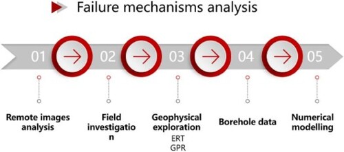
We took the Qianlingshan open-pit slope in Beijing, China, as the research object, by comprehensive application of historical remote sensing images analysis, field investigation, electrical resistivity tomography (ERT) and ground penetrating radar (GPR), and comparative analysis with borehole data, to obtain the slope parameter such as resistivity and velocity of electromagnetic wave, and to ascertain the slope structure, potential slip surface and deformation zone. On this basis, the geological generalisation model of slope was established, and the failure mechanism and stability of slope were analyzed by numerical simulation.
GRAPHICAL ABSTRACT
Acknowledgements
We would like to acknowledge Chunyu Liu and his team from China Coal Geology Group Company Limited for their invaluable assistance in the field work. We are also grateful to Prof. Chao Shen and Dr. Xin Huang for their comments that helped to improve the first version of paper.
Disclosure statement
No potential conflict of interest was reported by the authors.