
ABSTRACT
The space claims necessary for ensuring the liveability of public spaces often clash with on-street parking demand for private vehicles. Balancing these needs in a fair discussion has proven difficult. Demand for parking is expressed in clear-cut numbers, while liveability is a more emergent and qualitative concept. This paper seeks to (1) define the physical values of liveability; (2) translate them into generic space claims; (3) confront these claims with the demand for parking places in existing urban neighbourhoods; and (4) explore how this information could inform public debate and policy.
Introduction
Improving the liveability of existing urban public space by placemaking
Residents and local authorities are increasingly considering how to improve the liveability of streets by placemaking in existing neighbourhoods. The topic is not new. Already in the 1960s and 1970s, safety, meeting places, children’s play areas, and greenery were considered important values to reflect in street design. For instance, the Netherlands initiated the innovative ‘woonerf’ (‘home zone’) concept (Auttapone, Wilson, and Dunn Citation2014; Dumbaugh and King Citation2018). ‘Play Streets’ also have a long history in many countries (Cowman Citation2017; Umstattd Meyer et al. Citation2019). In recent years, the need for climate adaptation and the transition to sustainable mobility (less space for cars, more space for active transport modes) added urgency to the drive to enrich and diversify urban streets (Holden, Gilpin, and Banister Citation2019). Often these qualities are referred to as the original, holistic qualities of the street, which were replaced by the hegemonic space claims of traffic, especially the motor car (Norton Citation2015). According to the Project for Public Spaces (Citation2012, 3), ‘Streets, in particular, have for millennia been a vital part of the public realm, providing a place where merchants can sell their wares, children can play, and people can stop to talk. The growing prevalence of the automobile has squeezed out these uses. Reclaiming streets as places for people can strengthen cities in various ways – economically, environmentally, and socially’. Accordingly, various bottom-up ‘placemaking’ initiatives have laid space claims to enable socializing, greenery, playing, walking and cycling, both in developed countries and emerging economies (Akbar and Edelenbos Citation2021; Gundlach et al. Citation2018; Guzman et al. Citation2021; Hassen and Kaufman Citation2016; Jain and Moraglio Citation2014; Jones, Marshall, and Boujenko Citation2008; Nieuwenhuijsen and Khreis Citation2016; Selzer and Lanzendorf Citation2019; Soni and Soni Citation2016; Wen et al. Citation2019). Wyckoff (Citation2014, 2) defines placemaking as the ‘process of creating quality places that people want to live, work, play and learn in’. In short, placemaking is the process of creating liveable streets.
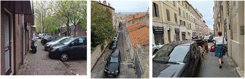
The tension between parking and placemaking attracts increasing attention in Western countries in Europe (Gössling et al. Citation2022), the United States (Weinberger and Karlin-Resnick Citation2015; Yanocha et al. Citation2021) but also in countries with emerging economies (Ibrahim Citation2017). In all these contexts, particularly in relatively compact urban neighbourhoods, the pressure of residential parking is growing and threatening the liveability of the streets. The current street layout is often geared to offer as many parking spaces as possible. Furthermore, sidewalks increasingly serve as a place for numerous utilities, including parking metres, lighting, waste disposal, and electric vehicle charging stations. The sidewalk is a short conduit through which you can walk from the house door to the car. Greenery is usually only present in the form of trees in between the parking spots. Most streets are in fact just walkable parking lots ().
Figure 1. Residential streets are walkable parking lots in European cities: examples from the Netherlands and France (Photos by authors).
Placemaking and parking
Bottom-up placemaking initiatives are one approach to question the dominance of cars and traffic in the design and regulation of streets. Local residents and users propose redesigning public space, sometimes facilitated by local government. The numerous international initiatives show the unique value of citizen participation and the transformative potential of the incremental approach. They might lead to awareness of the benefits of placemaking, but the impacts are often local and temporary (Bertolini Citation2020; Lydon and Garcia Citation2015; Ortegon-Sanchez et al. Citation2017; Schönfeld, Carlotta, and Bertolini Citation2017). This situation raises important questions. Can such efforts also lead to structural liveability improvements of entire neighbourhoods and districts? Could top-down measures by the city government enhance this bottom-up approach? At the same time, shaping conditions that encourage placemaking initiatives could improve the chance of impacting long-term neighbourhood and district changes. Pursuing this aim, however, also triggers sensitive issues, often leading to heated political debates. Most notably, the desire for placemaking, shared by many stakeholders (residents, activists, professionals and policymakers), seems to be at odds with the demand for parking spaces by car-owning residents. A citizens’ council held in 2022 in The Hague (Netherlands) illustrates this situation. Most proposals for improving liveability and sustainability were adopted by an overwhelming majority of residents, except: ‘About the presence of cars, for example, very different opinions were mentioned: at least the same number of parking spaces against the car in the long run completely out of the neighbourhood’ (Burgerberaad Statenkwartier Citation2022, 11).
How can local governments shape conditions for placemaking by reducing parking in public spaces? As the urban population and densities increase worldwide, the demand for residential parking is rising on the policy agenda. In the case of urban restructuring (demolition and construction of new homes), this demand can be addressed with concentrated parking lots or underground garages on the resident’s property (despite the resulting increase in housing prices). However, the vast majority of the housing stock already exists, especially in developed economies. Interventions in the existing private stock have proven difficult. Particularly in dense urban areas, there is little room to cater for residential parking in new parking lots or underground garages without disrupting the urban fabric. In European cities, new parking is situated below existing public spaces, but this is very costly and feasible only in high-end markets (Gemeente Amsterdam Citation2020). Studies in the US show that underground parking norms restrain new developments (Grabar Citation2023) and can also impede some public space uses, such as tree planting or rainfall absorption.
Another approach is to focus on reducing car ownership. This is interesting because, in addition to the possibilities for placemaking at the neighbourhood scale, it can also influence mobility demand at the urban level, with multiple benefits. After all, reducing car ownership can also lead to less car use, especially in urban environments (Nijland, van Meerkerk, and Hoen Citation2015). ‘Pull’ interventions include stimulating car sharing, safe and attractive bicycle connections, improving public transport and redesigning liveable streets, as in the popular ‘15-minute city concept’ (Moreno et al. Citation2021). The introduction of ‘mobility hubs’ is one recent additional example (Arnold et al. Citation2023). Nevertheless, these innovations are implemented only on a limited scale and mostly in new developments (Zwikker Citation2021). In addition, and perhaps most importantly, as long as most urban inhabitants still can park their cars for free or at low costs at a short distance from their doors (Zijlstra, Bakker, and Witte Citation2022), it is highly questionable whether these alternative mobility-oriented measures can by themselves lead to more support for the removal of parking spaces in residential neighbourhoods.
While removing parking places is still a delicate issue, in urban European neighbourhoods, regulated parking for non-residents is gradually gaining support with the aim to limit parking by visitors, employees, and residents of other districts. The result is improved access to parking by residents. In some cases, even vacant parking spaces might occur. Regulated parking requires setting a fixed number of parking permits. For instance, the Municipality of Maastricht in the Netherlands applies a permit ceiling of 120% of the available parking places, an approach of setting the ceiling based on the number of existing parking spaces. Consequently, placemaking is only possible in the ‘residual space’ of the street not used for parking.
While most current approaches focus on regulating parking without questioning its place on top of the hierarchy of street space allocation, there also seems to be an opportunity for an alternative narrative (Te Brömmelstroet et al. Citation2022). What if the priorities were reversed? What if, instead of first determining the space needed for parking and allowing placemaking in the leftover space, the space needed for placemaking is set first, and the leftover area is allocated to parking? This would provide a radically different approach to setting a permit ceiling. The starting point would be that parking and liveability are societal – and even priority – needs, especially when accounting for the fact that a large share of households does not own a car in many, if not most, cities. On average, 41% of households in London have no car, rising to 58% in inner London. In cities like Bremen and Hamburg, 40% of households do not own a car (Mahmud, Cottell, and Harding Citation2023; MHCLG Citation2023; Mobilität in Deutschland Kurzreport: Hamburg und Metropolregion Citation2018). In the central parts of cities in the Netherlands, car ownership is around 0.5 cars per household (CBS Citation2019, Citation2020). Residents without cars mostly walk or bike to their destinations (which could be a public transport stop) and, therefore, have a vested interest in placemaking. Also, many car-owning households appreciate placemaking. Determining the basic quality of liveability could help structure the discussion among residents about the trade-offs between placemaking and parking. The primary aim is not to reduce parking spaces but to improve the quality of public space and address the needs of all residents.
Research question
Although in most cases residents agree to enhance liveability, its space claims often conflict with an existing and still growing demand for the parking of private cars (Independer Citation2021). In order to provide ground for a fairer discussion, this paper addresses the following research question: To what extent is current car ownership in urban residential areas an obstacle to enhancing liveability in public spaces?
This core research question is further articulated through the following sub-questions:
- Looking at climate adaptation and enabling active modes of transport, play and encounters, what are the generic space claims for walking, cycling, greenery and play in the profile of existing streets?
- How many parking spaces in urban residential areas should be removed to accommodate these space claims?
- How does current and future parking demand based on car ownership in existing neighbourhoods relate to the maximum allowable parking capacity after satisfying liveability space claims?
The article is structured as follows. Section 2 deals with the methodology of translating liveability into generic space claims. Section 3 compares these space claims with the current parking demand of residents in four representative urban residential areas of Maastricht as an illustrative case of a medium-sized European city. Section 4 presents the discussion of the findings and conclusions, followed by limitations of the study and suggestions for further research.
Methodology
Creating space for placemaking
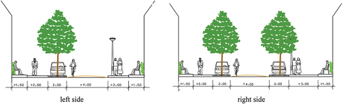
The balance between liveability and what could be termed ‘parkability’ in a residential area is ultimately a political and not a neutral or technical choice and, therefore, should be subject to public debate. Balancing societal demands in a fair discussion proves problematic because the demand for parking is expressed in consolidated norms and clear-cut numbers. At the same time, liveability as a concept has a more emergent and qualitative character. Nevertheless, several manuals and recommendations for placemaking have been developed, often according to street type (Dumbaugh and King Citation2018; Gemeente Amsterdam Citation2023; Gemeente Groningen Citation2021; Jones, Marshall, and Boujenko Citation2008; Kips et al. Citation2007; NACTO Citation2013; Ow Citation2009; Steemers Citation2012; Van Driessche et al. Citation2021). The first step is to identify the core values that underpin placemaking and then translate them into space claims based on recommendations from the existing literature. These values are the street’s microclimate and the space available for active modes, socialization and play, and provide a ‘benchmark’ for placemaking. This approach defines the street’s basic qualities and establishes a starting point for a discussion about the trade-offs between space for placemaking and space for parking. Some space claims can be combined to provide basic quality, such as room for playing and walking and water collection in parking zones. It must be kept in mind that space claims in themselves are not sufficient to create quality. Layout, materials, size, health and positioning of trees, street furniture and other important factors play a role. Nevertheless, space claims shape the necessary conditions for redesigning streets and improving their quality over time.
Placemaking values and associated space claims
Looking at each category, several important components with different spatial implications emerge (see ).
— Microclimate. Trees are a proven means to improve the climate at street level. They provide shade and purify the air. In addition to trees, there must be room for water collection. This can be technically solved by water-permeable pavement (e.g., as parking spaces), which does not require extra space. Greener forms of water collection (e.g., wadis and green strips) also have the additional advantage of improving the microclimate.
— Active mobility (walking and cycling). At a minimum, there must be free walking space for two people to pass each other on both sides of the street (Bochner et al. Citation2010; Dumbaugh and King Citation2018; Gemeente Amsterdam Citation2020; Jones, Marshall, and Boujenko Citation2008). In addition to a car or another motorized vehicle moving in one direction, there must always be room for cyclists to bike in two directions (ASVV Citation2021) and to park their bicycles. A road width of 4 metres allows one way for cars and two ways for cycles. Cycling requires space for movement but is also considered a part of placemaking as the lower speed allows social interaction with pedestrians.
— Socialization. In this respect, a private-public transition zone is crucial. Sometimes referred to as the facade zone, a front garden can fulfil this function. In its absence, space should be reserved for benches or greenery as an alternative transition from private to public space.
— Playing. Playable residential streets have a sidewalk at least 3 metres wide on one side, preferably under direct sunlight (Steemers Citation2012; Umstattd Meyer et al. Citation2019) (also accessible to other pedestrians). In combination with the sidewalk, green strips can be arranged locally into a play area. In the ‘woonerf’ design, the roadway is also used for walking and playing.
— Street furniture. Lighting, trash cans, benches and other structures should not infringe upon walking space and should be spaced at a minimum distance of 50 metres (Gemeente Amsterdam Citation2020).
Table 1. Space claims for placemaking in street profiles.
To identify streets where parking spaces should be removed, firstly the basic space claims were translated into two typical street profiles in compact environments in European cities. Some functions can be combined, such as trees and water collection in parking spaces and water collection in green front gardens (if present). Based on the basic quality of liveability, parking has tipping points. A width above 16 metres between the facades provides room for two rows of parking (, right-hand side). A width between 13 and 16 metres would allow only one row (, left-hand side). A width of less than 13 metres cannot accommodate parking spots unless the sidewalk and roadway are combined into a shared-space residential area that can accommodate all uses: motorized vehicles, playing, socializing, walking and cycling. If there appears to be no tension between the basic space claims for placemaking and existing parking in wider streets, there could be room for optimal space claims. This inquiry is, however, not part of this study.
Figure 2. Basic quality placemaking space claims for common street profiles in European cities.
Case selection
Three urban residential neighbourhoods in the city of Maastricht, Netherlands (around 120,000 inhabitants) were selected as illustrative cases for the analysis: Wittevrouwenveld, Heugemerveld, and Mariaberg. In terms of built structure and density, they typify many urban residential neighbourhoods in Western Europe: single-family homes (predominantly terraced houses, some semi-detached) mixed with medium-high apartment buildings. With around 0.5–0.6 cars per household, car ownership is comparable to urban residential areas in European cities, and inhabitant density is ca. 50 households per hectare (Gemeente Maastricht Citation2016; CBS Citation2020; Mahmud Citation2024; Mahmud, Cottell, and Harding Citation2023; MHCLG Citation2023).
One neighbourhood (Boschpoort) with a significantly lower density and higher car ownership was added to obtain a more comprehensive picture. shows a typical streetscape in the selected neighbourhoods, and shows their basic characteristics.
Figure 3. Street views of the selected neighbourhoods in Maastricht. (Photos by author).
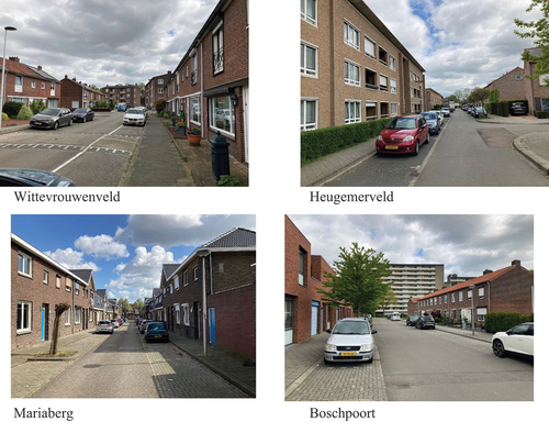
Table 2. Densities, property types and car ownership in the case study neighbourhoods.
Findings
Redesigning streets for placemaking
All streets in the four neighbourhoods were analysed on their basic quality for liveability. In some streets, there is room for placemaking within the existing profile, for example, by greening existing front gardens, creating water-permeable parking spaces and improving the growing conditions for trees. In others, however, the space needed for placemaking would lead to removing one row of parking and, in some cases, changing from cross-parking to row parking. Some streets are so narrow that, to provide sufficient space for walking and cycling, the roadway would have to be used as a shared space, as in a woonerf profile. Subsequently, a comparison was made between the supply of parking spaces after deducting space for placemaking and the parking demand of residents at district level.
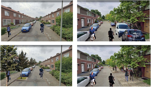
shows two examples of street profiles before and after placemaking in the Boschpoort neighbourhood. On the left side, placemaking (bottom picture) results in planting trees between parking spaces (more greenery). In contrast, the right side demonstrates the removal of a row of parking, which creates a sufficiently spacious sidewalk (more space for walking and playing).
Figure 4. Examples of existing (above) and greened (below) profiles in the Boschpoort neighbourhood (Illustrations by H. Peeters).
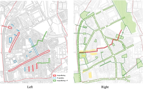
The left section of shows which street interventions would be needed to realize basic placemaking quality at the level of a whole neighbourhood, which is exemplified by Wittevrouwenveld. The streets marked in red are wide enough to meet the demands of liveability and maintain the current number of parking spaces. Streets in blue and green indicate where parking spaces should be removed. The right-hand side of shows what the realization of a basic placemaking quality can deliver for the Wittevrouwenveld neighbourhood as a whole: (1) tree avenues with spacious sidewalks along the main access roads (30 km/h maximum speed); (2) green streets that link the existing parks (30 km/h maximum speed); and (3) a car-free residential route (in red) providing a pleasant and safe route to access the shopping centre, the primary school and the district park.
Figure 5. Possible elaboration at neighbourhood level for Wittevrouwenveld.
Assessing the residual supply of public parking spaces after placemaking
Following the approach that the supply of parking places should not simply follow demand but should be restricted by the space claims of liveability, firstly the supply of on-street parking spaces in the four neighbourhoods are shown before and after the redesign (), indicating that placemaking would eliminate between 6% and 16% of the existing stock.
Table 3. The supply of public parking spaces before and after placemaking.
Assessing residential parking demand
shows the demand for residential parking, car ownership and observed occupancy of parking spaces by visitors and residents during the daytime. In addition to car ownership, the numbers noted at 23:00 on Thursday give a reliable picture of total residential on-street parking demand because most people are at home. The big difference between the number of cars residents own, and parking space occupancy at 23:00 can partly be explained by the fact that residents also use private, off-street parking spaces.
Table 4. Residential demand for parking in public spaces.
Comparing residential parking demand and supply after placemaking
shows the number of parking spaces vacant or accessible for visitors or employees after placemaking (i.e., residual capacity of on-street parking spaces). These parking spaces could also accommodate a possible future increase in car ownership. The expected number of permit applications has been determined by reducing the number of residents’ cars with the supply of private parking spaces.
Table 5. Comparing parking supply and demand after placemaking.
Even after placemaking, if all car owners were to occupy a parking space, a parking surplus remains in the four neighbourhoods (albeit quite limited in Boschpoort due to the original low number of parking spots and high motorization rate). There may even be room to further improve liveability by pursuing optimal space claims instead of basic ones.
Assessing current and maximum car ownership
shows the current and, from the point of liveability, maximum car ownership per neighbourhood, assuming that residents use all of the available private parking spaces.
Table 6. Current and maximum allowable car ownership per neighbourhood.
Addressing the research questions
- Looking at climate adaptation and enabling active modes of transport, play and encounters, what are the generic space claims for walking, cycling, greenery and play in the profile of existing streets?
In Section 2.2, these generic space claims for placemaking were formulated.
- How many parking spaces in urban residential areas should be removed to accommodate these space claims?
Applying the space claims for placemaking, as formulated in Section 2.2, it appears that several streets in the analysed neighbourhoods already have a basic quality, or at least the amount of space needed to create liveability. In these streets, residential parking demand is not an obstacle to creating liveability. In some streets, the roadway can be narrowed to provide more spacious sidewalks and maintain the current number of parking spaces. However, on many streets, the sidewalks are too narrow and lack facade zones. There is not enough space for walking, playing and socializing. In some, the roadway is so narrow that bicycles and oncoming cars cannot pass each other. Finally, trees are often missing. Cross-parking would have to be changed into parallel parking in some streets, while in other, narrower streets, one row of parking would have to be removed. The estimate puts the overall required reduction in parking space between 6% and 16%.
- How does current and future parking demand based on car ownership in existing neighbourhoods relate to the maximum allowable parking capacity after satisfying liveability space claims?
All neighbourhoods still host a surplus of parking spaces after placemaking for non-residents (visitors, employees, or loading and servicing), at least during the day. On Thursday at 23:00, the theoretical residual parking capacity (vacant parking spaces) varies between 24% and 29% in three neighbourhoods with relatively low car ownership. In Boschpoort, with car ownership of 0.9 cars/household, this is only 6%. In this case, there is already a high parking occupancy rate, resulting in parking pressure by residents, leading to increasing walking distances and time spent on finding a parking place even at 23:00 in some streets. In several streets, this challenge would be reinforced by placemaking. Refraining from placemaking would, however, deliver only a minor relief of parking pressure (from 94% to about 92%). It should be noted that despite having enough parking spaces for residents, as well as visitors and employees, or loading and servicing, local walking distances from home to one’s car would increase. The maximum acceptable distance in the Netherlands is about 200 metres (Oostenbrink and Lankhorst Citation2021).
Conclusions and discussion
Conclusions
Parking regulation provides municipalities with a powerful instrument to shape conditions for placemaking. However, the maximum number of parking permits (the permit ceiling) for residents must be based on the space needed for future placemaking, not on the current available parking space. The study reveals that the basic space for placemaking in some cases eats into the available parking space; however, the initial overall conclusion is that within the studied neighbourhoods, with densities of ca. 50 households/ha and car ownership around 0.6 cars/household, every car owner can secure a parking permit. Parking pressure may increase in specific locations as not everyone would be able to park in front of their door. Residents would have to accept longer walking distances to make placemaking possible. In a neighbourhood with car ownership of 0.9 cars/hh, it may be necessary to realize parking spaces on the edge of the neighbourhood (parking hubs), especially considering the current high parking pressure by residents. A second overall conclusion is that in neighbourhoods with comparable densities and with more than 0.8 cars/hh, placemaking initiatives would face substantial pushback by residents. However, this also depends on the number of existing private parking spaces.
Discussion points
These results lead to four discussion points.
- Are the described generic space claims appropriate for the variety of neighbourhoods within cities?
- Is applying technical, quantitative norms sufficient to realize spatial quality?
- Could insights as described in this paper contribute to the discussions with residents?
- In what measure is it possible to anchor basic qualities for liveability in municipal or even national guidelines?
The space claims as described seem appropriate for the urban fabric of many pre-war and early post-war (1950s and 1960s) European urban areas, with clearly defined streets and building blocks. In most cases, the tensions between parking and placemaking in these central urban areas are quite evident. For more suburban areas or high-rise buildings in green settings, the tensions between parking and placemaking can be quite different and should be approached differently. Nevertheless, something reflecting the spirit of our approach (first determining the space needs for placemaking and only then assessing implications for parking) would still be valuable.
The values and corresponding norms, as introduced in this paper, are generic space claims, comparable with, for example, building codes, not design proposals. They also explore the possible frictions between placemaking, parking supply, and parking demand. It must be kept in mind that space claims shape necessary conditions but are in themselves not sufficient to create quality. Layout, materials, size, health and positioning of trees, street furniture and other important factors play a role.
One of the lessons learned in participatory processes is that, to convince residents, the advantages of placemaking should be presented with attractive images of possible future situations (Van Driessche et al. Citation2021). However, in some cases, redesigning streets could mean that walking distances to parking increase, provoking resistance from many car-owning residents. On the other hand, the method might also give extra support and, thus, a voice to the non-car owners in the neighbourhood, who, just because they do not own a car, are excluded from the right to claim a significant portion of public space. Although the method and results outlined in this paper have not been used in participatory processes, they can inform such initiatives by highlighting the extent of parking ‘security’ that residents still enjoy after placemaking (next to visualizing the gains in liveability). The insights could enhance the willingness to carry out street experiments, for example, as a temporary arrangement of street design and regulation to experience ‘for real’ both the potential benefits and costs of placemaking (Bertolini Citation2020).
Finally, these quantitative tools could help anchor the basic qualities for liveability in municipal or national guidelines, in line with comparable standards for traffic safety or building regulations. The public value of liveability could then be viewed as a right for all residents and set against the private interests of car owners to park their cars in front of their houses.
Policy considerations
Interventions like a permit ceiling do not address the issue of new parking demand, for example, due to rising residential densities, gentrification or an increase in the home delivery of goods. This question touches on a fundamental discussion at city level, namely, how to accommodate a potential increase in car and van density and maintain liveability levels. While this is largely a political question, three potential solutions provide a starting point for discussion.
Adding more parking spaces
To maintain the basic liveability of streets, clustered remote parking (neighbourhood parking hubs) could be provided, either as parking garages or at street level. This solution might, however, not be desirable from the point of view of urban mobility policy. Increasing car ownership also leads to more car use (Nijland, van Meerkerk, and Hoen Citation2015) and generates demand for parking spaces at destinations.
Not adding more parking spaces
Not adding more parking spaces would likely lead to waiting lists for a permit. This could be done in combination with providing shared cars and alternative modes of transport in so-called mobility hubs in strategically located places, creating a market for shared mobility and decreasing car use across the city.
Using parking spaces differently
Variably priced permits could be issued for the use of a parking space. Parking places are standardized (5.50–6.00 m long and 1.80–2.00 m wide), and each could accommodate 2 or 3 microcars or multiple e-scooters. Currently, permits are given per parking place. Alternatively, permits could be given for vehicles per square metre of space. By offering vehicle permits per square metre, more permits can be issued while maintaining the desired liveability level. More parking spaces would be created but for smaller vehicles. A market would be created for microcars as an urban means of transport instead of the conventional car.
A final, more general, policy consideration lies beyond creating liveable residential streets and engages with the larger challenge of transitioning to sustainable urban mobility. A fair discussion about liveability at a neighbourhood level can lead to a scarcity of parking space, which could decrease car ownership. This could reduce the overwhelming space consumed by cars in urban areas, not only in residential streets but also at destinations and city centres.
Limitations and further research
The analyses focused on the neighbourhood level, which does not allow for assessing the effects of walking distances to parked cars. Other efforts should look at a smaller scale, for example, by dividing the neighbourhood into several units of acceptable walking distance between the main roads.
Second, as a city as a whole, Maastricht has a relatively low average car ownership (0.64 cars per household) and exhibits a declining trend. As shown in , car ownership in the urban residential areas of European cities is very similar. However, potential intra- and inter-city differences and the appropriate interventions should be explored in greater detail.
Disclosure statement
No potential conflict of interest was reported by the author(s).
References
- Akbar, P. N. G., and J. Edelenbos. 2021. “Positioning Place-Making As a Social Process: A Systematic Literature Review.” Cogent Social Sciences 7 (1): 1905920.
- Arnold, T., M. Frost, A. Timmis, S. Dale, and S. Ison. 2023. “Mobility Hubs: Review and Future Research Direction.” Transportation Research Record 2677 (2): 858–868.
- ASVV. 2021. Aanbevelingen voor Verkeersvoorzieningen Binnen de Bebouwde Kom. Ede: CROW.
- Auttapone, K., D. J. Wilson, and R. Dunn. 2014. “A Review of the Evolution of Shared (Street) Space Concepts in Urban Environments.” Transport Reviews 34 (2): 190–220.
- Bertolini, L. 2020. “From “Streets for traffic” to “Streets for people”: Can Street Experiments Transform Urban Mobility?” Transport Reviews 40 (6): 734–753.
- Bochner, B. S., P. J. Caruso, J. M. Daisa, L. M. F. Tierney, L. E. Gibson, J. Norquist, J. T. Obenberger, et al. 2010. “Designing Walkable Urban Thoroughfares: A Context Sensitive Approach.” Designing Walkable Urban Thoroughfares: A Context Sensitive Approach. Part 3, 57–105, no. RP-036A. Washington DC: Institute of Transportation Engineers. https://deldot.gov/Business/drc/manuals/ite_walkable_thoroughfares.pdf.
- Burgerberaad Statenkwartier. 2022. Adviezen voor de gemeenteraad over klimaatverandering en -adaptatie. Den Haag: Raadsinformatie. RIS314047RIS314047_Bijlage_1.
- CBS (Centraal Bureau voor de Statistiek). 2019. “Afstand tot treinstation, autobezit per wijk.” Accessed January, 2023. https://www.cbs.nl.
- CBS (Centraal Bureau voor de Statistiek). 2020. ”Autobezit per huishouden.” Accessed January, 2023. https://www. cbs.nl.
- Cowman, K. 2017. “Play Streets: Women, Children and the Problem of Urban Traffic, 1930–1970.” Social History 42 (2): 233–256.
- De Groot Volker. 2019. Parkeeronderzoek 10 deelgebieden Maastricht. Maastricht: Gemeente Maastricht.
- Dumbaugh, E., and M. King. 2018. “Engineering Livable Streets: A Thematic Review of Advancements in Urban Street Design.” Journal of Planning Literature 33 (4): 451–465.
- Gemeente Amsterdam. 2020. “Frans Halsbuurt: opnieuw inrichten.” Accessed 2023. https://www.amsterdam.nl/projecten/franshalsbuurt.
- Gemeente Amsterdam. 2023. Ruimte voor de voetganger. Beleidskader Verkeer and Openbare Ruimte. Gemeente Amsterdam.
- Gemeente Groningen. 2021. Leef- en klimaatstraten, een nieuw perspectief op de straat. Groningen: Gemeente Groningen.
- Gemeente Maastricht. 2016. “Gemeente Maastricht in cijfers en grafieken”. Accessed 2023. https://allecijfers.nl/gemeente/Maastricht.
- Gössling, S., A. Humpe, R. Hologa, N. Riach, and T. Freytag. 2022. “Parking Violations As an Economic Gamble for Public Space.” Transport Policy 116 (3): 248–257. https://doi.org/10.1016/j.tranpol.2021.12.010.
- Grabar, H. 2023. Paved Paradise: How Parking Explains the World. London: Penguin.
- Gundlach, A., M. Ehrlinspiel, S. Kirsch, A. Koschker, and J. Sagebiel. 2018. “Investigating people’s Preferences for Car-Free City Centers: A Discrete Choice Experiment.” Transportation Research Part D: Transport & Environment 63:677–688. https://doi.org/10.1016/j.trd.2018.07.004.
- Guzman, L. A., D. Oviedo, J. Arellana, V. Cantillo-García. 2021. “Buying a Car and the Street: Transport Justice and Urban Space Distribution.” Transportation Research Part D: Transport & Environment 95:102860. https://doi.org/10.1016/j.trd.2021.102860.
- Hassen, N., and P. Kaufman. 2016. “Examining the Role of Urban Street Design in Enhancing Community Engagement: A Literature Review.” Health & Place 41:119–132. https://doi.org/10.1016/j.healthplace.2016.08.005.
- Holden, E., G. Gilpin, and D. Banister. 2019. “Sustainable Mobility at Thirty.” Sustainability 11 (7): 1965.
- Ibrahim, H. 2017. “Car Parking Problem in Urban Areas, Causes and Solutions.” In 1st International Conference on Towards a Better Quality of Life, Berlin.
- Independer. 2021. “Onderzoek: toename autobezit.” Accessed January, 2023. https://www.independer.nl.
- Jain, A., and M. Moraglio. 2014. “Struggling for the Use of Urban Streets: Preliminary (Historical) Comparison Between European and Indian Cities.” International Journal of the Commons 8 (2): 513–530.
- Jones, P., S. Marshall, and N. Boujenko. 2008. “Creating More People-Friendly Urban Streets Through ‘Link and place’street Planning and Design.” IATSS Research 32 (1): 14–25.
- Kips, E., M. Kramer, S. Schepel, Schouten, and M. Zomervrucht. 2007. Spelen op straat. Delft: IIUE.
- Lydon, M., and A. Garcia. 2015. Tactical Urbanism: Short-Term Action for Long-Term Change. Washington, DC: Island Press. https://doi.org/10.1080/01944363.2015.1054708.
- Mahmud, Z., J. Cottell, and C. Harding. 2023. “Moving with the Times.”
- Mahmud, Z. 2024. “Understanding Car Ownership in London.” Accessed January, 2024. https://centreforlondon.org/blog/car-ownership-census.
- MHCLG. 2023. Number and Density of Dwellings by Borough (2001–2019) Updated 2023. London, UK: Ministry of Housing, Communities and Local Government (MHCLG).
- Mobilität in Deutschland. 2018. Kurzreport: Hamburg und Metropolregion. Bonn: Bundesministerium für Verkehr und digitale Infrastruktur.
- Moreno, C., Z. Allam, D. Chabaud, C. Gall, and F. Pratlong. 2021. “Introducing the “15-Minute City”: Sustainability, Resilience and Place Identity in Future Post-Pandemic Cities.” Smart Cities 4 (1): 93–111.
- NACTO. 2013. Urban Street Design Guide. Washington Island Press. https://doi.org/10.5822/978-1-61091-534-2.
- Nieuwenhuijsen, M. J., and H. Khreis. 2016. “Car Free Cities: Pathway to Healthy Urban Living.” Environment international 94:251–262. https://doi.org/10.1016/j.envint.2016.05.032.
- Nijland, H., J. van Meerkerk, and A. Hoen. 2015. Effecten van autodelen op mobiliteit en CO2-uitstoot. Den Haag: PBL Planbureau voor de Leefomgeving.
- Norton, P. 2015. “Of Love Affairs and Other Stories.” In Incomplete Streets: Processes, Practices, and Possibilities, edited S. Zavestoski and J. Agyeman, 17–35. Abingdon: Routledge.
- Oostenbrink, E., and A. Lankhorst. 2021. Inzicht in acceptabele loopafstanden. Ede: CROW-KpVV.
- Ortegon-Sanchez, A., C. Popan, and N. Tyler. 2017. “Car-Free Initiatives from Around the World: Concepts for Moving to Future Sustainable Mobility.” TRB 96th Annual Meeting Compendium of Papers, Washington DC.
- Ow, E. P. A. 2009. “Green Streets: A Conceptual Guide to Effect Green Streets Design Solutions.”
- Project for Public Spaces. 2012. Placemaking and the Future of Cities. 3
- Schönfeld, V., K. Carlotta, and L. Bertolini. 2017. “Urban Streets: Epitomes of Planning Challenges and Opportunities at the Interface of Public Space and Mobility.” Cities 68:48–55. https://doi.org/10.1016/j.cities.2017.04.01210.
- Selzer, S., and M. Lanzendorf. 2019. “On the Road to Sustainable Urban and Transport Development in the Automobile Society? Traced Narratives of Car-Reduced Neighborhoods.” Sustainability 11 (16): 4375. https://doi.org/10.3390/su11164375.
- Soni, N., and N. Soni. 2016. “Benefits of Pedestrianization and Warrants to Pedestrianize an Area.” Land Use Policy 57:139–150. https://doi.org/10.1016/j.landusepol.2016.05.009.
- SPARK. 2021. Review laadvermogen openbare ruimte Maastricht. Maastricht: Gemeente Maastricht.
- Steemers, M. 2012. Rotterdamse norm voor buitenspeelruimte. Rotterdam: Gemeente Rotterdam.
- Te Brömmelstroet, M., M. N. Mladenović, A. Nikolaeva, İ. Gaziulusoy, A. Ferreira, K. Schmidt-Thomé, and R. Ritvos, et al. 2022. “Identifying, Nurturing and Empowering Alternative Mobility Narratives.” Journal of Urban Mobility 2:100031.
- Umstattd Meyer, M. R., C. N. Bridges, T. L. Schmid, A. A. Hecht, and K. M. Pollack Porter. 2019. “Systematic Review of How Play Streets Impact Opportunities for Active Play, Physical Activity, Neighborhoods, and Communities.” BMC Public Health 19:1–16. https://doi.org/10.1186/s12889-019-6609-4.
- Van Driessche, M., J. De Groot, E. Redekop van der Meulen, C. G. Leung, and S. Chen. 2021. Nieuwe Ruimte, Ontwerpleidraad leefkwaliteit openbare ruimte. Groningen: Gemeente Groningen.
- Weinberger, R. R., and J. Karlin-Resnick. 2015. “Parking in Mixed-Use US Districts: Oversupplied No Matter How You Slice the Pie.” Transportation Research Record 2537 (1): 177–184.
- Wen, L., J. Kenworthy, X. Guo, D. Marinova. 2019. “Solving Traffic Congestion Through Street Renaissance: A Perspective from Dense Asian Cities.” Urban Science 3 (1): 18.
- Wyckoff, M. A. 2014. “Definition of Placemaking: Four Different Types.” Planning & Zoning News 32 (3): 1.
- Yanocha, D., T. Das, M. Kodransky, and J. Mason. 2021. “On-Street Parking Pricing: A Guide to Management, Enforcement, and Evaluation.”
- Zijlstra, T., S. Bakker, and J. Witte. 2022. Het wijdverbreide autobezit in Nederland. Den Haag: KiM. https://www.kimnet.nl/publicaties/publicaties/2022/02/22/het-wijdverbreide-autobezit-in-nederland.
- Zwikker, R. 2021. Hubs in bestaande wijken. Rotterdam: Vereniging Deltametopool.