
ABSTRACT
Regional enlargement and Transit-Oriented Development (TOD) has in Sweden been an active policy and strategy at both municipal, regional, and national level to make society more resource efficient and strengthen local labour markets. The paper aims to explore and discuss how strategic local-regional planning can be used to counteract local, municipal and sub-regional uneven development enhanced by city-centric transit-oriented development. Mutual learning processes between local and regional actors can be used to benefit regional investments and manage local expectations. This means including local knowledge of the local situation and local knowledge of the regional context in the regional planning process and to institutionalize local-regional integration and common projections of TOD.
1. Introduction
1.1. Uneven regional development
Applied at the regional level, ‘Transit Oriented Development’ (TOD) is commonly considered a planning strategy that facilitates sustainable transport systems (Hrelja et al., Citation2020; Nigro et al., Citation2019) and increased access to jobs and workers through shorter travel times (Deboosere et al., Citation2018). Most of the literature on successful implementation of TOD address the problems with fragmentation between actors on different planning levels and the need to work on multiple levels (Björling & Capitao Patrao, Citation2021; Pettersson & Frisk, Citation2016; Thomas & Bertolini, Citation2015). At the same time, medium and small municipalities in fringes of the larger metropolitan regions tend to work less with integrated planning between infrastructure and land-use planning, and it is difficult to transfer TOD to these situations (Capitao Patrao, Citation2022; Staricco & Brovarone, Citation2018). Apart from Qviström et al. (Citation2019) Nigro et al. (Citation2019), and Hrelja et al. (Citation2022) there are few, if any, empirical studies of a regional TOD-strategy from the low-density European context as is found in large parts of the Nordic countries.
During the last decades spatial planning and urban design in European countries has enhanced their ambitions to handle geo-political competition, regional enlargement, and regional transition to a circular economy (European Union, Citation2024). Resulting in an ongoing process of testing and development of cross-administrative collabortions, policy networks and rescaling of mandates with the ambition to strengthen the dynamics of spatial planning and a more strategic approach to local-regional development (Sielker, Citation2018; Smas & Schmitt, Citation2020; Björling, Citation2022). Sweden is in this context an interesting example of a country where planning practice, since the 1980s, has been characterized by a strong belief in regional enlargement and urban growth (Björling & Rönnblom, Citation2023; Johansson et al., Citation2021). Sweden is also an example of how planning practice has tried to develop a more strategic approach to collaboration between local, municipal, and regional planning (Gustafsson et al., Citation2019; Hrelja et al., Citation2022). These strategies for local-regional planning have on the one hand been successful in strengthening regional competitiveness in a sparsely populated country (Björling, Citation2020). On the other hand, these strategies tend to strengthen a city-centric perspective within both municipal and regional planning where the problems and potentials of the larger cities are prioritized (Björling & Rönnblom, Citation2023; Brenner, Citation2019; Keil et al., Citation2016). Investments in the regional core(s) with the goal to provide ‘most for the most’ has not resulted in expected regional trickle-down effects (Holgersen & Baeten, Citation2016). The result is rather an uneven geographic development (Björling & Fredriksson, Citation2018; Slätmo, Citation2015). When the city-centered problems and TOD-strategies developed for urban areas are prioritized in the overall region, one risk is that it obscures an overall regional perspective and enhances a city-centric approach to transit-oriented development.
Against this background, the paper aims to explore and discuss how a strategic approach to local-regional planning can be used to counteract local, municipal and sub-regional uneven development enhanced by city-centric transit-oriented development.
The case study is based in the Västra Götaland region in Sweden with three local contexts (Munkedal, Vänersborg and Herrljunga) along two railway lines (Älvsborgsbanan and Bohusbanan) (see ).
Figure 1. The study area of the Västra Götaland region with its railway infrastructre and the three municipalities Munkedal, Vänersborg and Herrljunga with station communities along the two railway lines Bohusbanan and Älvsborgsbanan. On the map are also the four municipal federations marked. Sources: GSD-Översiktskartan vektor, GSD-Vägkartan vektor, © Lantmäteriet; Sverige järnvägsnät, Trafikverket.
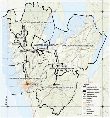
The Västra Götaland region is Sweden’s largest region in terms of population, with just over 1.7 million inhabitants. The region consists of 49 municipalities and four municipal federations (co-operative organisations of municipalities that coordinate inter-municipal and subregional planning. Federations have their own political board with representatives from their municipalities. Initiatives are based on concensus where all members agree to collaborate). The study adds to the knowledge of TOD-strategies at a regional level with a focus on a Nordic context of sparsely populated areas including smaller towns of non-urban character.
2. Integrating and coordinating local and regional planning
2.1. The capacity of strategic spatial planning
Swedish regional planning has been discussed in several national reports during the last years (see for example Regeringskansliet, Citation2018, Citation2021, Citation2023; SOU, Citation2015). Ongoing European initiatives such as Fit for 55 and New European Bauhaus also influence national and regional initiatives with the ambition to increase collaboration and the strategic capacity of local-regional and national planning actors (European Union, Citation2024; Rådet för hållbara städer, Citation2022). Today, only 3 out of 21 regions have implemented an official function of regional spatial planning. However, all regions in Sweden work with regional strategies to some degree to deal with planning of infrastructure, housing, energy production and environmental protection (Grundel, Citation2022). The overall changes in regional planning during the last decades can be described as the result of a transition from a regional distribution policy to a regional competition policy (Johansson et al., Citation2021). The political consequences of governance models and uncritical intersectoral collaborations has been developed as a central theoretical issue within the field of strategic planning (see, among others, Albrechts & Balducci, Citation2013; Granqvist et al., Citation2021; Healey, Citation2007; Tietjen & Jörgensen, Citation2016; Trygg & Wenander, Citation2022). The strategic potential is often described as a combination of formulating common long-term visions for the planning process and at the same time sort out and distribute responsibilities to different actors (Albrechts & Balducci, Citation2013). Moreover, strategic planning needs to include an openness for mutual learning between involved actors (Isaksson & Hagbert, Citation2020). It can also benefit from a design-oriented approach where strategies are developed through an iterative process of articulating problems, projecting imaginaries, visions and formulating possible moves with ‘positive’ outcomes (Davoudi & Brooks, Citation2021; Tietjen & Jörgensen, Citation2016). At the same time, strategic planning enhances competition between for example municipalities (Granqvist et al., Citation2021) and has been discussed as a central part of the shift from government to governance, new public management, and part of a neo-liberal agenda (Allmendinger & Haughton, Citation2012; Keil et al., Citation2016; Olesen, Citation2014). Especially in relation to a city-centred planning process where regionalisation often is seen as a regional collaborative ‘public-private’ and ‘market driven’ project to attract economic investments and increase international competitiveness (Björling, Citation2020; Davoudi & Brooks, Citation2021).
The strategic capacity is according to Trygg and Wenander (Citation2022, 1993) relatively good within the municipalities in Sweden where the organization has mandate to easily transfer knowledge between different planning instruments and coordinate political goals between political committees and departments. However, the potential for strategic planning on a regional level is limited by the possibilities to renegotiate overall visions. Real implementations are constrained by for example conflicting land-use, or priorities between different goals and when consensus is not possible to reach (Trygg & Wenander, Citation2022). Furthermore, Johansson et al. (Citation2021) address that current governance models do not clarify the distribution of responsibilities nor provide the opportunity for accountability.
2.2. Transit-oriented development – to coordinate multiple scales
The importance of coordination and collaboration between local, municipal, regional, and national actors has also been highlighted by researchers working with TOD (Hrelja et al., Citation2020; Ibraeva et al., Citation2020; Staricco & Brovarone, Citation2018; Thomas & Bertolini, Citation2015). Among the most important factors for a successful implementation of TOD at the regional level are political stability at the national level, inclusion of transdisciplinary knowledge and good relationships between actors at national and regional level (Thomas & Bertolini, Citation2015). Based on research in a Swedish context these factors are, according to Hrelja et al. (Citation2020, p. 20), often of informal institutional character. The process is enabled or constrained by the relationships between actors at different planning levels, and their willingness to experiment with new policies, practices, and tools. Thereby, it is according to Hrelja et al. (Citation2020) important to consider complex governance structures and different understandings of TOD since a static understanding of local development from a regional perspective reduces the possibilities to work in integrated processes between the regional and local level.
Research on TOD is mainly found in the context of urban and metropolitan regions (Ibraeva et al., Citation2020), and as such brings urban connotations which are less suitable for low-density areas where municipal initiatives often struggle to interact with the regional and national levels (Capitao Patrao, Citation2022). Yet the strategy has gained interest in low-density regions and municipalities to facilitate local and regional sustainable development. Despite important contributions to tailor TOD to peripheral contexts (Qviström, Citation2015) and the need to coordinate and synchronize planning levels and actors (Thomas & Bertolini, Citation2015), there are still knowledge gaps concerning how regional ambitions impact the local situation.
2.3. The station community as a boundary object for strategic governance
The ability to coordinate efforts from several actors with the intention of implementing common interests is described by Fredriksson (Citation2015) as strategic governance. A process which often requires large efforts because different actors have different interests and act with different time perspectives (Fredriksson, Citation2015, p. 18). To handle these situations, Fredriksson (Citation2015, p. 20) argues for a joint learning process where initial orientations to the work are open to adaptation and renegotiation. A process which raises important strategic questions (Fredriksson, Citation2015, p. 20) such as: What issues must be dealt with jointly? Which ones need to be dealt with now and which ones can wait? Are there conflicts of interest? And how do we organize a process that creates the conditions for everyone to act for the desired development?
The coordination and knowledge transfer that Fredriksson (Citation2015) calls for is also highlighted by Forsemalm et al. (Citation2015). Based on theoretical work by Akkerman and Bakker (Citation2011), Forsemalm et al. (Citation2015) describe the station as a boundary object – a common point in the process for different professions, disciplines, and planning levels. The station as a boundary object between the local (place) and the regional (node) can be seen as a starting point for a planning process that both gathers skills and perspectives but can also articulate conflicts and conflicting interests. Forsemalm et al. (Citation2015) highlight that concrete change often needs an iteration between articulating conflicts and bridging contradictions in a joint learning process around complex challenges. This means that all actors involved in the process need to be prepared to re-evaluate their own roles (Forsemalm et al., Citation2015).
Against this background, we will in the next sections describe how regional transit-oriented development has highlighted the conflicts of city-centric regional competition and potentials of strategic local-regional spatial planning. Strategic governance and boundary objects have been used to analyse the case of planning for station communities in the Västra Götaland region.
3. A design based and projective approach
This case study was organized through an initial workshop followed by a site visit, additional mapping, interviews and a second workshop. The work was conducted by the authors in collaboration with two officials from Region Västra Götaland (VGR) who constitute the work group, while the authors also were part of an overarching research group in the project Co-creative urban planning for energy-efficient and sustainable station communities carried out from March 2017 to December 2020 (Svensson et al., Citation2020).
The methodological framework has used case study methodology (Flyvbjerg, Citation2006) and a design-based approach to combine qualitative mapping, interviews, and projective imaginaries (Dyrssen, Citation2010). The work process with document studies, workshops, mapping and interviews has been documented through notes, digitalization of sketches, interview transcripts and logbook entries. A chronological compilation of the process (Björling & Capitao Patrao, Citation2021) and continuous interplay between practice and theory through workshops, meetings with the work group and the research group have been important parts in the analysis where theory has been tested and developed continuously to problematize the mapping and planning process.
The first workshop in January 2018 was held as two meetings, one for each of the two railway lines. At the workshop officials from Region Västra Götaland, the Swedish Transport Administration, Västtrafik (the public transport company owned by Region Västra Götaland), municipal federations, and municipalities along the two railway lines participated. For details see . The purpose of the workshop was to clarify the municipalities’ perspectives on the regional development of transport systems and residential development with a starting point in station communities (Björling & Capitao Patrao, Citation2021). The participants discussed and created maps of their local understandings of the regional context of which they are part. The workshop was followed by analysis and mapping by the work group. The work resulted in the choice of three towns with a train station in the Västra Götaland region, namely Dingle in Munkedal municipality, Öxnered in Vänersborg municipality, and Ljung-Annelund in Herrljunga municipality. The authors visited the chosen towns in spring 2018 to map site-specific prerequisites and held meetings with officials in each of the three municipalities.
Table 1. Participants at workshop 1 regarding Bohusbanan, Stenungsund 2018-01-24.
Table 2. Participants at workshop 1 regarding Älvsborgsbanan, Borås 2018-01-25.
To deepen the understanding of local and municipal perspectives on the development of towns with train stations, nine interviews were conducted in spring 2018, see . After the interviews, the work group summarized and analyzed the results as critical factors for the development of the towns in the regional context.
Table 3. List of interviews with municipal officials and politicians (interview 1–9) and interviews with officials at the regional and state level (interview 10–14).
In spring 2019, another five interviews were made with officials and politicians at the municipal, regional and state level, see . During autumn 2019, the work group and research group worked with analysis of the collected data and results through collaborative writing of a research report (Björling & Capitao Patrao, Citation2021) and formulated tentative conclusions which were discussed with practitioners at the second workshop. The second workshop took place in February 2020 where five officials from the VGR departments for infrastructure and cultural development attended.
4. Case area description
4.1. Munkedal municipality – Dingle
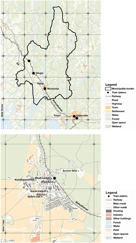
The municipality of Munkedal with 10 500 inhabitants is an inland municipality in Fyrbodal municipal federation (see ). The municipality is characterized by a small-scale and hilly landscape. There are about 4 000 people living in the municipality’s administrative centre, the town of Munkedal, and 900 residents in Dingle. In the comprehensive plan, Munkedal centre is highlighted as important for maintaining and strengthening services in the municipality (Munkedal municipality, Citation2017, p. 28). The municipal strategy for expansion is to localize new housing to areas that already have access to infrastructure, public transport, roads, water, and sewage (Munkedal municipality, Citation2017, p. 35). Locations close to infrastructure and stations are identified as strategic for residential development (Munkedal municipality, Citation2017, p. 12).
Due to the terrain and the route of the railway Bohusbanan, the station in Dingle is located on the eastern edge of the town (see ). In Dingle, the objective is to work with densification of the existing town and its central parts. The location of the station in the eastern part of the urban area gives the opportunity to use the edge of the mountain to the east of the area with a view of the landscape for residential development within walking and cycling distance to the station (Munkedal municipality, Citation2017, p. 41). The railway is described as significant to the identity of Dingle. However, the railway competes with the road E6 for fast communications to work and commercial activities. The shopping area Torp outside Uddevalla () also affects the commercial supply in Munkedal and Dingle. The road E6 is considered to have a competitive advantage over the railway regarding accessibility to the regional labour market, and the train service is above all important for commuting opportunities to the upper secondary school in Uddevalla.
Figure 2. a-b, Munkedal municipality (above), and Dingle (below). Sources: GSD-Översiktskartan vektor, GSD-Vägkartan vektor, Topografi 10 Nedladdning, vektor, © Lantmäteriet; Sverige järnvägsnät, Trafikverket.
4.2. Vänersborg municipality – Öxnered
The municipality of Vänersborg has 39 400 inhabitants, where of 24 000 people live in the town Vänersborg and about 700 people in Öxnered and its surrounding areas. The municipality of Vänersborg has good accessibility to the railway and points to a potential in expanding traffic between the larger towns of Uddevalla, Trollhättan, and Gothenburg. The settlements in Vänersborg, Trollhättan, Överby and Öxnered are connected by the major roads E45 and road 44 (see ). Altogether, there are approximately 100 000 people living in the municipalities of Vänersborg and Trollhättan. In the comprehensive plan, station communities are identified as an important development strategy and land areas for residential development are identified around the stations (Vänersborg municipality, Citation2017, p. 97).
Figure 3. a-b, Vänersborg municipality (above), and Öxnered (below). Sources: GSD-Översiktskartan vektor, GSD-Vägkartan vektor, Topografi 10 Nedladdning, vektor, © Lantmäteriet; Sverige järnvägsnät, Trafikverket.
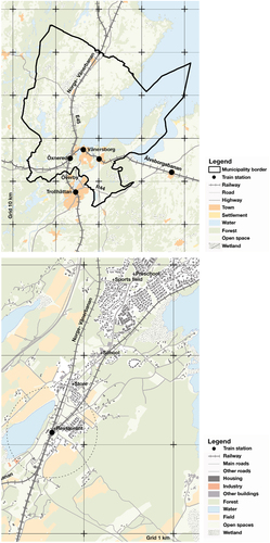
Öxnered is located at the junction between the Älvsborgsbanan and the Norge-Vänerbanan (see ). The station and the possibility of residential development east of the station is considered strategically important and one of the municipality’s most important development areas. The goal is to develop housing within walking and cycling distance from the station, with good accessibility for commuting, and in attractive locations along the water (Vänersborg municipality, Citation2016, p. 10). The willingness to invest is relatively high in Öxnered, but there are challenges in the implementation of the municipal plans as the area closest to the railway is influenced by noise from the railway and that areas along the lakes on both the east and west side are affected by coastal protection. In the area, there is a school, some services and restaurants but no grocery store.
4.3. Herrljunga municipality – Ljung-Annelund
Herrljunga municipality with 9 500 inhabitants is located at the intersection between the Älvsborgsbanan and the Västra Stambanan (see ). There are 4 000 people living in Herrljunga town and 1 200 in Ljung-Annelund. The population in the municipality has declined by 2 % between 2010 and 2018. The landscape is characterized by a slightly hilly topography with alternating forest and farmland. Herrljunga, as the central town in the municipality, is a historically important railway junction and has gradually developed around the station and the railway since the end of the 19th century. In both Herrljunga and Ljung-Annelund new buildings are promoted to be located within walking and cycling distance of the stations. According to the municipal comprehensive plan, the objective is a dense and functionally mixed urban area that provides the opportunity for different forms of housing (Herrljunga municipality, Citation2017, p. 21). The larger development area in Herrljunga is located north of the railway. Here, accessibility to the station is good, but the railway forms a barrier to other services south of the railway. However, the speed of transformation is slow, which means that the possibility of developing the areas with the goal of dense and functionally mixed use are limited.
Figure 4. Herrljunga municipality (above), and Ljung-Annelund (below). Sources: GSD-Översiktskartan vektor, GSD-Vägkartan vektor, Topografi 10 Nedladdning, vektor, © Lantmäteriet; Sverige järnvägsnät, Trafikverket.
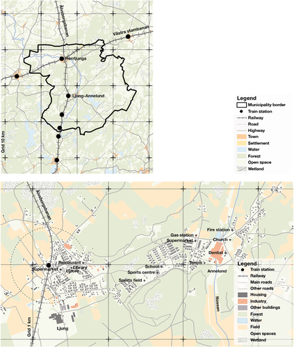
Ljung-Annelund has historically developed as two towns (see ). Annelund is a small industrial town and developed around the possibility of crossing the river Nossan and the access of hydropower. Ljung developed around the station and the courthouse. For Ljung-Annelund, new buildings are expected to be located nearby the existing infrastructure. The municipality sees great potential in Ljung-Annelund and there are several significant companies in the towns. However, the demand for new housing is weak, and it is difficult to get loans from the banks because of low housing prices. The situation is more positive in Herrljunga town.
5. Results
According to the interviews and workshops, the region lacks strategic capacity to handle the development of public transport provision in the smaller towns as it today takes place ‘in dialogue with good will’ between the municipality and the region (Interview, 13). In short, we see the need for the regional planning process to re-evaluate local and regional knowledge about geographical aspects, organisational aspects and projective aspects of the local-regional situation.
5.1. Geographical aspects
5.1.1. A diverse local-regional landscape
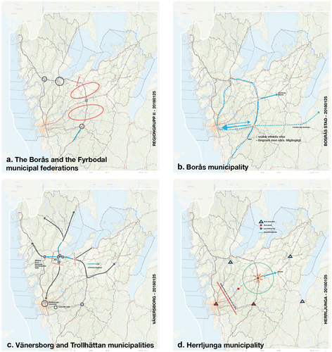
The initial workshop resulted in maps that articulate the relevance of the railways and public transport quite differently depending on geographical location (see ). For example, the municipalities in the north () highlighted how public transport to Östfold in Norway needs to be expanded to strengthen sub-regional development, which is not prioritized by the municipalities around Gothenburg. Along Älvsborgsbanan () municipalities highlighted a mental barrier for travelling that was discussed as a historical divide between the former counties of Älvsborg and Skaraborg. Furthermore, representatives from the municipalities and regional authorites highlighted that there are both internal and external geographical contexts and boundaries within the Västra Götaland region that need to be discussed to identify potentials and constrains for local-regional development ().
Figure 5. a-d: Mapping of Bohusbanan shows how actors point out how the railway is important in different ways depending on the local location. The railway can be seen as plural geographical contexts. Source background map: GSD-Översiktskartan vektor, GSD-Vägkartan vektor, © Lantmäteriet; Sverige järnvägsnät, Trafikverket.
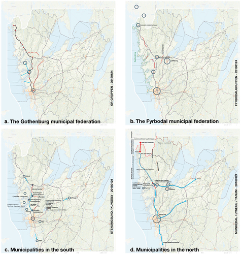
Figure 6. a-d: Mapping of Älvsborgsbanan shows how actors point out how the railway is important in different ways depending on the local location. The railway can be seen as plural geographical contexts. Source background map: GSD-Översiktskartan vektor, GSD-Vägkartan vektor, © Lantmäteriet; Sverige järnvägsnät, Trafikverket.
5.1.2. Local contradictions
The local-regional conditions was highlighted more in detail during the joint mapping in the meetings with the municipalities of Munkedal, Vänersborg and Herrljunga. In Munkedal, the Torp shopping area outside Uddevalla has established itself as a new destination for regional travel. The result is a generic built environment which risks depleting the historical significance of the smaller towns in the municipality. Bus travel on the E6 competes with train traffic and limits the opportunities to create residential development in locations close to existing train stations. The goal to develop the areas around the stations are outcompeted by the commercial development around Torp and along road E6.
In Vänersborg, the possibility to commute to Gothenburg was highlighted as a central potential for the development of Öxnered. This creates a situation where Gothenburg as the large city in the region can be seen to hit a wedge in the local labour market around Trollhättan and Vänersborg and reinforces a sub-regional competitive situation. It seems that, to reach Gothenburg from Öxnered by train becomes more important to the municipality than to develop the connections to the towns of Vänersborg and Trollhättan.
In Herrljunga, the topography and the historical settlement pattern do not match today’s regional commuting routes. The settlements along several ridges are difficult to supply with public transport in a rational way, which limits the possibilities for development in locations close to public transport. At the same time, the pace of the physical transformation is slow. The result is that the expected exploitation, based on experience from a more urban location, fails.
The interviews and meetings furthermore revealed that the smaller towns risk being described as more monofunctional than the larger towns and the smaller towns often have a more varied local activity than, for example, just a station. All the municipalities give a similar picture, that the school, the grocery store, and association life are of central importance for everyday life in the smaller towns (Interview, 1; 4; 7).
5.2. Organisational aspects
5.2.1. Cooperation, financing and lack of consensus
The workshops and interviews include a variety of perspectives on the regional planning process of smaller towns with a station. To Västtrafik, it is important to highlight the importance of working with residential development near the station and ‘not in the forest’ (Interview, 12). At the same time, there is criticism in the interviews that the municipalities do not invest or build more concentrated in existing towns, but instead mainly plan for single-family housing. VGR highlights that the region urges the municipalities to locate development near railways and stations, but civil servants also describe it as a challenge because the region looks the way it does. ‘We basically live everywhere and work more concentrated. We have a society that creates trips’ (Interview, 11). This corresponds to the overall political objective that: ‘the whole region should live’ (Interview, 10). At the same time, the officials point out that there is an economic reality to deal with, which means that public transport will be different in different parts of the region based on demand and there is an overall regional logic of ‘most to the most’ based on the demographic situation (Interview, 10). Overall, the regional priorities of the larger cities in the region highlight an organisational conflict in relation to interviews that emphasize that:
All the parts [of the region] are important. The regional ambition is for the entire region to be connected and then all railways should function and be in traffic. That is our strategy, long-term will, we agree with the municipalities on that. (Interview, 11)
It appears in the interviews with the regional and national officials, that there is an ambition to develop cooperation between the municipal, regional, and national level to a greater extent (Interview, 10; 11; 12; 13; 14). There is, according to one interview (13) a demand for ‘real regional planning’ but instead there is a lack of a clear regional strategy of which investments should be prioritized. According to the interview with the Swedish Transport Administration, the situation can be described as ‘a regional anxiety and regional politics and policy need to take the lead in this work’. Furthermore, in the interview with the County Administrative Board, it appears that more coordinated planning needs greater clarity for when different windows open up or close for planning at municipal, regional and state level (Interview, 13). The County Administrative Board is primarily involved in the consultation phase of planning, late in the process. It limits the opportunities to act proactively and add to the regional analysis at the municipal level (Interview, 13).
The problem with financing infrastructure is highlighted by the Swedish Transport Administration informant, who argues that the investments today are often spread over many smaller projects instead of focusing on fewer and larger ones. According to the interview, the reason for this is a lack of consensus around a joint long-term strategy, making it difficult to prioritize investments among the many parts of the infrastructure system that has shortcomings (Interview, 14). The lack of consensus is also highlighted by the officials at VGR who point to the diverse perspectives of the different planning levels. Infrastructure planning takes place from the national perspective and the regional perspective via the Swedish Transport Administration and VGR, while spatial planning and strategies for local development is handled at the municipal level. Since, the municipalities are in charge of spatial planning, there is a feeling among the regional officials that the region should not get involved in the municipal planning process.
At the second workshop, it was discussed that a central problem for extended collaboration between the departments at VGR and between the region and the municipalities is the organisation’s structure and lack of resources. There is limited time to hold a dialogue with all 49 municipalities, and there is a risk that an unbalanced inclusion of municipalities undermines transparency in the work process and creates democratic inequality. Instead, the dialogue is held on an inter-municipal level via the four municipal federations, which become central actors for knowledge transfer and political negotiations. Development opportunities therefore risk becoming dependent on how individual employees act and have knowledge of initiating and running projects.
5.3. Projective aspects
5.3.1. Joint talks facilitates a common strategic capacity
The joint talks of civil servants on municipal, inter-municipal, and regional level during the workshops provided a basis for discussing common issues. At the second workshop, the results from the research study were discussed and the participants projected future possibilities for coordination between the departments at VGR and collaborations with municipalities, local actors and other public authorities. The workshop provided a good opportunity for the two VGR departments to jointly analyse the results and make use of the stations as boundary objects in the discussion. During the conversation, it emerged that the region, through both ongoing work with a region-wide structural plan and participation in local development projects, has a good position for further coordination of local-regional perspectives. The region (VGR) can thus be an organization that ensures knowledge transfer between different actors and planning levels.
A possible way forward to coordinate planning is according to interview 13 and 14, a regional spatial planning process that could give the region better conditions for reaching consensus and better coordination in the planning of buildings, infrastructure and transport. It would provide the opportunity for an overall perspective along the various railway lines where the municipalities, based on their municipal planning perspective, prioritize the challenges experienced by their own municipality before the common social development in the region as a whole (Interview, 10).
6. Discussion: a critical dialogue and transfer of knowledge
There are no legal restrictions in the Swedish planning system for expanding coordination between planning levels. However, in many cases, there is no active regulation of land use on regional level to limit investments in new buildings and infrastructure that are inappropriate regarding for example sustainable transport, to reduce the environmental and climate impact or to counteract uneven geographic development. Therefore, the regional planning in Sweden is dependent on the municipalities to voluntarily negotiate proposals for overall strategies in the municipal regulation of land use through comprehensive planning and detailed development plans. In relation to these problems we, similarly to Forsemalm et al. (Citation2015), find stations to be important boundary objects that have the capacity to be used to create connections between planning levels and constitute common interest for knowledge transfer. As boundry objects, the stations create common interests where actors at different planning levels can build common local-regional knowledge and stage necessary negotiations. At the same time, the stations as boundry objects can be used as prototypes for new approaches to local-regional planning where experience and knowledge can be transferred to future initiatives and used in other fields of local-regional planning.
6.1. Local knowledge about the local condition
As can be seen from the workshops and interviews, there is extensive local knowledge about the station communities that today have difficulty to reach the regional planning process. The lack of knowledge about local conditions at higher organisational levels means that the region risks applying simplified visions for local TOD. The regional imaginaries are also often characterized by a city-centric perspective on local problems and potentials where it is expected that the smaller towns grow and the built environment transforms when train traffic is strengthened, and the possibility to commute increases. For example, officials in Munkedal municipality highlight that it is significantly more expensive to build on the hilly land around the station than on the flat agricultural land south of the community (interview, 4). The municipality with a weak economy is thereby forced to plan for housing and industrial land at greater distances from the station and in locations that require more car transport. In Öxnered, the conflict with the shoreline protection is mentioned by the officials (interview, 7). Since it is the values of the shoreline that are described as attractive in Öxnered these values risk conflicting with a more expansive development around the station. Investments in expansion and more extensive changes to the towns thus become problematic in relation to the values that the national planning wants to protect and that the current town offers (interview 1).
To counteract these conflicts, the local knowledge about the local situation needs to be included in the regional planning process to expand the understanding of what a station and TOD in the smaller towns mean. The local situation needs to be discussed based on a diversity of local and regional conditions. Local development cannot be based solely on accessibility to the station but needs to be discussed as accessibility to a variety of everyday functions such as housing, jobs, services, and recreation. Depending on how the accessibility to these destinations looks as a whole, the use of public transport and local development are affected. Thus, stations can be used as boundry objects that bridge between a broader understanding and analysis of local conditions that can be the basis for state, regional, municipal, and local decisions about changes in infrastructure and the built environment.
6.2. Local knowledge about the regional context
Local conditions also affect the opportunity to travel to a workplace by train depending on if the journey takes place to or from the smaller town. For example, the station in Ljung-Annelund serves as a station for a larger surrounding countryside traveling to Borås or Herrljunga. However, the station has poorer possibilities for trips to Ljung-Annelund as the local workplaces lie relatively far from the station, and those who commute to work at these companies do not live near a station. In a similar way, Öxnered is described as a station with a sub-regional catchment area and is the ‘station’ for many inhabitants in the surrounding areas who will travel south or east (interview, 7).
The regional and national infrastructures have different importance in different regional contexts and affect the municipalities’ development opportunities and the functional geographical context of everyday life in various ways. The local perspectives on the regional context given in this paper articulate the importance of including local perspectives and local knowledge to inform a wider understanding of the regional prerequisites. This implies that investments in different infrastructures and planning for different sectors and interests create conflicts. For example in Herrljunga, the relationships to work, education and leisure are strongly linked to the railway and the road towards Gothenburg. In Ljung-Annelund, the relationships are instead linked to Borås (interview, 2). Corresponding infrastructural corridors are found in Munkedal municipality, but there it is rather a competition between the railway and the road E6. Shops and service have decreased in Dingle after the relocation of road E6 outside of town. At the same time, the local environment has improved after the removal of a large amount of heavy traffic (interview, 4). The officials in Herrljunga and Munkedal describe that there is little infrastructure and public transport between the major infrastructure corridors in the region, which means that transport by car is required at the expense of using the railroad (interview, 1; 4). Therefore, Munkedal municipality tends to plan for commercial locations along the motorway and not in proximity to the stations in Munkedal and Dingle. Furthermore, the potential for development and commercial service (place qualities) in Munkedal centre is limited by the infrastructural investments that increase the node qualities for Torp shopping centre.
Today, the region and the municipalities often come to an agreement regarding investments from the state. At the same time, it is more difficult to work with priorities along the different railway lines, since the work takes place in various groups adjusted to the specific planning project where planners from the state, the region and the municipalities are represented. However, the mandate for political negotiation is weak in the actual meetings where alternatives are projected and discussed. Instead, the formal negotiation takes place via the municipal federations, which tend to make other political priorities that falls back to administrative division rather than see the specific railway as a whole. At the regional level, the prioritization does not take place based on spatial planning but based on infrastructure and public transport provision. To counteract this situation, it is important to articulate the dominating perspectives and priorities, articulate the local-regional conflicts, but also project the potential of local knowledge and perspectives missing.
6.3. Local-regional integration and projective visions for TOD
This paper does not present a framework for what a more strategic approach to local-regional planning should look like. Such a framework needs to be tailored to each regional context. However, building on the experience from the second workshop initiated by the project, Region Västra Götaland implemented a new project during 2022 and 2023 (VGR, Citation2023). The first step in the project was to start a common discussion about local-regional development between the Department of infrastructure and public transport and the Department of regional development. By combining the knowledge and mandate from the two regional departments, the region could invite both local, municipal, regional and national actors to joint workshops where knowledge from the different actors were shared based on the opening of two new train stations in the region. The project ended with a presentation for invited regional and municipal politicians to discuss possible strategic changes in the regional planning process. The project can be seen as a test for sharing local knowledge about the local and regional situation and regional knowledge about the local and the regional. The project has not been a formal planning process according to the regulation of regional planning in Sweden. Rather, the process can be seen as a forum for sharing knowledge. The stations can be further implemented as boundary objects for transferring knowledge and can be seen as objects for disciplinary and professional analysis and stages for political negotiations. Here, the process can find inspiration in models for strategic governance where forum, arena and court are seen as recurrent stages in the local-regional planning process (Fredriksson, Citation2015). Sharing knowledge (forum), professional analysis (arena) and political negotiation (court) are at the same time stages that should be emphazised in the actual transfer of knowledge and negotiation in relation to available resources and conflicting interests. However, the transfer of knowledge should be seen as mutual between involved actors and planning levels. Common projections of future potentials beyond stereotyped visions of sustainable TOD and overall mission-oriented local-regional development should be at the core of such process.
7. Conclusions
7.1. A synchronized local-regional planning process and institutionalised knowledge transfer
A city-centred TOD increases the competitiveness of the big city through regional enlargement and increased train traffic to the regional cores. However, the city-centric perspective on local-regional planning outlined in this paper also risks limiting a more holistic understanding of both the needs and consequences of regional enlargement. A city-centric perspective leads to investments that strengthen proximity or relationships to the centres being logical and rational to prioritize. At the same time, investments that connect other areas of the region to each other without moving through the bigger cities are deprioritized.
To counteract this situation, stations can be used as boundry obejcts to develop a more strategic approach to local-regional planning. Knowledge and mandate from different organizational bodies such as the state, the region, the municipalities and local communities, can be coordinated in relation to their resources and initiatives. It does not only call for good relationships between actors at different planning levels but also for a more dynamic approach to strategic governance where relevant competences, resources and decisions are combined and integrated to gain institutionalized strategic capacity. To do so, the study emphasises the need for regional actors to include local knowledge on the local, local knowledge on the regional and a projective approach where stakeholders from different planning levels can engage and collaborate within their different mandates and responsiblities. By addressing the local consequences of regional investments and regional consequences of local investments, a more dynamic local-regional planning can counteract uneven development enhanced by a city-centric approach to transit-oriented development.
Disclosure statement
No potential conflict of interest was reported by the author(s).
Additional information
Funding
References
- Akkerman, S. F., & Bakker, A. (2011). Boundary crossing and boundary objects. Review of Educational Research, 81(2), 132–23. https://doi.org/10.3102/0034654311404435
- Albrechts, L., & Balducci, A. (2013). Practicing strategic planning: In search of critical features to explain the strategic character of plans. DisP - the Planning Review, 49(3), 16–27. https://doi.org/10.1080/02513625.2013.859001
- Allmendinger, P., & Haughton, G. (2012). Post-political spatial planning in England: A crisis of consensus? Transactions of the Institute of British Geographers, 37(1), 89–103. https://doi.org/10.1111/j.1475-5661.2011.00468.x
- Björling, N. (2020). Belysning av det svenska planeringssystemet genom jämförelse med planeringsprocessen i Älvstaden. Fusion Point, Göteborgs stad.
- Björling, N. (2022). Planning for quality of life as the right to spatial production in the rurban void. In P. H. Johansen, A. Tietjen, E. B. Iversen, H. L. Lolle, & J. K. Fisker (Eds.), Rural quality of life (pp. 215–231). Manchester University Press.
- Björling, N., & Capitao Patrao, C. (2021). Sam-Sam – samskapande samhällsplanering för hållbara och energieffektiva stationssamhällen, Delstudierapport: Västra Götalandsregionen (Arbetspaket 1). KTH/Energimyndigheten.
- Björling, N., & Fredriksson, J. (2018). Relationer Mellan stad och land i det regionala stadslandskapet. Mistra Urban futures Rapport 2018:1.
- Björling, N., & Rönnblom, M. (2023). Politics of the rurban void. Space and Polity, 1–20. https://doi.org/10.1080/13562576.2023.2248036
- Brenner, N. (2019). New urban spaces: Urban theory and the scale question. Oxford University Press.
- Capitao Patrao, C. (2022). Transit-oriented development and sparse settlement structures. The case of western Sweden. European Planning Studies, 31(10), 2170–2195. https://doi.org/10.1080/09654313.2022.2114790
- Davoudi, S., & Brooks, E. (2021). City-regional imaginaries and politics of scalar fixing. Regional Studies, 55(1), 52–62. https://doi.org/10.1080/00343404.2020.1762856
- Deboosere, R., Levinson, D., & El-Geneidy, A. (2018). Accessibility-oriented development. Journal of Transport Geography, 70, 11–20.
- Dyrssen, C. (2010). Navigating in heterogenity: Architectural thinking and art-based research. In M. Biggs (Ed.), The Routledge companion to research in the arts (pp. 223–239). Routledge.
- European Union. (2024). Retrieved April 14, 2024, from. https://new-european-bauhaus.europa.eu/index_en
- Flyvbjerg, B. (2006). Five misunderstandings about case-study research. Qualitative Inquiry, 12(2), 219–245. https://doi.org/10.1177/1077800405284363
- Forsemalm, J., Johansson, M., & Svetoft, I. (2015). Att lära sig utveckla regionen genom kommunen Urbana stationssamhällen som verktyg för ett hållbart transportsystem. Chalmers University of Technology.
- Fredriksson, C. (2015). En processmodell för strategisk samhällsplanering – Forum, Arena, Court. Forskningsprogrammet Stadsregioner och utvecklingskraft (STOUT) Rapport 2015:1 KTH.
- Granqvist, K., Mattila, H., Mäntysalo, R., Hirvensalo, A., Teerikangas, S., & Kalliomäki, H. (2021). Multiple dimensions of strategic spatial planning: Local authorities navigating between rationalities in competitive and collaborative settings. Planning Theory & Practice, 22(2), 173–190. https://doi.org/10.1080/14649357.2021.1904148
- Grundel, I. (Ed.). (2022). Regioner och regional utveckling i en föränderlig tid. Svenska sällskapet för antropologi och geografi.
- Gustafsson, S., Hermelin, B., & Smas, L. (2019). Integrating environmental sustainability into strategic spatial planning: The importance of management. Journal of Environmental Planning and Management, 62(8), 1321–1338. https://doi.org/10.1080/09640568.2018.1495620
- Healey, P. (2007). Urban complexity and spatial strategies – towards a relational planning for our times. Routledge.
- Herrljunga municipality. (2017). Översiktsplan för Herrljunga kommun. Herrljunga kommun.
- Holgersen, S., & Baeten, G. (2016). Beyond a liberal critique of “trickle down”: Urban planning in the city of Malmö. International Journal of Urban & Regional Research, 40(6), 1170–1185. https://doi.org/10.1111/1468-2427.12446
- Hrelja, R., Olsson, L., Petterson-Löfstedt, F., & Rye, T. (2020). Transit Oriented Development (TOD) a litterature review. K2 research 2020:2 K2.
- Hrelja, R., Olsson, L., Pettersson-Löfstedt, F., & Rye, T. (2022). Challenges of delivering TOD in low-density contexts: The Swedish experience of barriers and enablers. European Transport Research Review, 14(1), 1–11. https://doi.org/10.1186/s12544-022-00546-1
- Ibraeva, A., Correira, G. H., Silva, C., & Antunes, A. P. (2020). Transit oriented development: A review of research achievements and challenges. Transportation Research Part A: Policy and Practice, 132(2020), 110–130. https://doi.org/10.1016/j.tra.2019.10.018
- Isaksson, K., & Hagbert, P. (2020). Institutional capacity to integrate ‘radical’ perspectives on sustainability in small municipalities: Experiences from Sweden. Environmental Innovation and Societal Transitions, 36, 83–93. https://doi.org/10.1016/j.eist.2020.05.002
- Johansson, J., Rönnblom, M., & A, Ö. (2021). Democratic institutions without democratic content? – new regionalism and democratic backsliding in regional reforms in Sweden. Frontiers in Political Science, 3. https://doi.org/10.3389/fpos.2021.711185
- Keil, R., Hamel, P., Boudreau, J.-A., & Kipfer, S. (2016). Governing cities through regions: Canadian and European perspectives. Wilfrid Laurier University Press.
- Munkedal municipality. (2017). Framtidsplan ÖP18 Munkedal, Samrådshandling. Munkedals kommun.
- Nigro, A., Bertolini, L., & Moccia, F. D. (2019). Land use and public transport integration in small cities and towns: Assessment methodology and application. Journal of Transport Geography, 74(2019), 110–124. https://doi.org/10.1016/j.jtrangeo.2018.11.004
- Olesen, K. (2014). The neoliberalisation of strategic spatial planning. Planning Theory, 13(3), 288–303. https://doi.org/10.1177/1473095213499340
- Pettersson, F., & Frisk, H. (2016). Soft space regional planning as an approach for integrated transport and land use planning in Sweden – challenges and ways forward. Urban, Planning and Transport Research, 4(1), 64–82. https://doi.org/10.1080/21650020.2016.1156020
- Qviström, M. (2015). Putting accessibility in place: A relational reading of accessibility in policies for transit-oriented development. Geoforum; Journal of Physical, Human, and Regional Geosciences, 58, 166–173. https://doi.org/10.1016/j.geoforum.2014.11.007
- Qviström, M., Luka, N., & De Block, G. (2019). Beyond circular thinking: Geographies of Transit‐Oriented Development. International Journal of Urban & Regional Research, 43(4), 786. https://doi.org/10.1111/1468-2427.12798
- Rådet för hållbara städer. (2022). Program till idéskisser – New European Bauhaus. Rådet för hållbara städer. Retrieved April 14, 2024, from. www.hallbarstad.se
- Regeringskansliet. (2018). Regeringens proposition 2017/18:226 – en ny regional planering. Näringsdepartementet.
- Regeringskansliet. (2021). Nationell strategi för hållbar regional utveckling 2021-2030.
- Regeringskansliet. (2023). Nationell fysisk planering DS 2023:28. Landsbygds-och infrastrukturdepartementet.
- Sielker, F. (2018). European spatial governance – towards a sectoralisation of spatial planning. Journal of Property, Planning and Environmental Law, 10(2), 126–139. https://doi.org/10.1108/JPPEL-03-2018-0011
- Slätmo, E. (2015). Stationers roll för utveckling av mindre orter och dess omland. Kunskapssammanställning och forskningsbehov. Working papers in human geography. Department of Economics and Society,
- Smas, L., & Schmitt, P. (2020). Positioning regional planning across europé. Regional Studies, 55(5), 778–790. https://doi.org/10.1080/00343404.2020.1782879
- SOU 2015:59. (2015). En ny regional planering – ökad samordning och bättre bostadsförsörjning (Betänande av bostadsplaneringskommitén). Fritzes Offentliga Publikationer.
- Staricco, L., & Brovarone, E. V. (2018). Promoting TOD through regional planning. A comparative analysis of two European approaches. Journal of Transport Geography, 66, 45–52. https://doi.org/10.1016/j.jtrangeo.2017.11.011
- Svensson, T., Björling, N., Capitao Patrao, C., Ekelund, B., Hidman, E., Legeby, A., Ranhagen, U., & Troglio, E. (2020). Samskapande Samhällsplanering för energieffektiva och hållbara stationssamhällen. KTH, Rapport.
- Thomas, R., & Bertolini, L. (2015). Defining critical success factors in TOD implementation using rough set analysis. Journal of Transport and Land Use, 10(1), 139–154. https://doi.org/10.5198/jtlu.2015.513
- Tietjen, A., & Jørgensen, G. (2016). Translating a wicked problem: A strategic planning approach to rural shrinkage in Denmark. Landscape and Urban Planning, 154, 29–43. https://doi.org/10.1016/j.landurbplan.2016.01.009
- Trygg, K., & Wenander, H. (2022). Strategic spatial planning for sustainable development – Swedish planners’ institutional capacity. European Planning Studies, 30(10), 1985–2001. https://doi.org/10.1080/09654313.2021.2001792
- Vänersborg municipality. (2016). Program för Detaljplaner för Skaven och delar av Öxnered. Vänersborgs kommun.
- Vänersborg municipality. (2017). Översiktsplan 2017. Vänersborgs kommun.
- VGR. (2023). Stationsutveckling och samhällsplanering. www.vgregion.se