
 ?Mathematical formulae have been encoded as MathML and are displayed in this HTML version using MathJax in order to improve their display. Uncheck the box to turn MathJax off. This feature requires Javascript. Click on a formula to zoom.
Abstract
Agricultural Land Suitability Analysis plays a pivotal role in sustainable land use planning, aiding decision-makers in identifying areas most conducive to agriculture. This study employs a systematic approach integrating Analytical Hierarchy Process and Multi-Criteria Decision Analysis techniques to assess and prioritize the suitability of agricultural land in in Southern Punjab (Multan region). The methodology involves defining clear objectives, identifying relevant criteria and sub-criteria, establishing a hierarchical structure and conducting pairwise comparisons to determine the relative importance of each factor. Our outcomes indicated that almost 43% area was highly suitable for agriculture, 27% moderately suitable, 16% marginally suitable, 8% less suitable and 6% not suitable for agriculture in study area. All the suitable lands had silty clay or clay type soil, which had sandy loam type soil in Multan region. The output is a comprehensive suitability map that identifies the most suitable areas for agriculture in Multan region. Sensitivity analysis and validation are incorporated to enhance the robustness and reliability of the results. This methodology provides a valuable tool for land use planners and policymakers to make informed decisions regarding agricultural land allocation, contributing to sustainable agricultural practices and resource management.
REVIEWING EDITOR:
1. Introduction
Analysis of land suitability is the procedure of the valuation of land which is intended to be used for a specific task such as agriculture in regionally (Bariotakis et al., Citation2019; Gilani et al., Citation2020; Yang et al., Citation2023). Agriculture has become a prominent concern since the early twenty-first century due to tremendous rise in the global population (AbdelRahman et al., Citation2016; Akpoti et al., Citation2019; Elsheikh et al., Citation2013; Jiao et al., Citation2023). The change in agriculture and impacts of climate variability are more severe in areas where plants are less resistant to high temperatures (A. Ali et al., Citation2023; Mubeen et al., Citation2023; Zolekar & Bhagat, Citation2015). Long-term and short-term climate change is predicted to affect agricultural production negatively in terms of crop suitability and yield in various regions (G. B. Ahmed et al., Citation2016; Aymen et al., Citation2021; He et al., Citation2023; Nguyen et al., Citation2020; Vincent et al., Citation2019). Soil texture refers to the relative proportions of sand, silt and clay particles present in a given soil (Zhao et al., Citation2020; Zhu et al., Citation2022). These particles vary in size, with sand being the largest, silt intermediate and clay the smallest (Cheng et al., Citation2023; Pant et al., Citation2023). The combination of these particles determines the soil’s texture (Luo et al., Citation2022). Soil fertility is a measure of the soil’s ability to provide essential nutrients to plants for optimal growth and development (Kazmi et al., Citation2023; Kumar & Pant, Citation2023). Soil fertility is influenced by factors such as organic matter content, microbial activity and nutrient cycling within the soil (Rawat et al., Citation2022; Zheng et al., Citation2023). Soil drainage is the ability of the soil to allow water movement through its profile (Hu et al., Citation2023; Kumar et al., Citation2021). Assessing soil drainage is essential in agricultural land suitability analysis, as it directly impacts crop selection, irrigation practices and overall land management strategies. Proper drainage contributes to soil aeration, root development and the prevention of water-related stress on crops (Kumar et al., Citation2022; Shang et al., Citation2023; Zhang et al., Citation2023).
Geographic information system (GIS) and remote sensing (RS) have played an important role in land suitability analysis. The spatial nature of identifying an acceptable site for agriculture necessitates using GIS tools (Li et al., Citation2023; Yalew et al. Citation2016). The GIS is a technique for integrating geographically referenced data due to its intrinsic procedures and processes (Griffel et al., Citation2022; Seyedmohammadi & Navidi, Citation2022). Multi-Criteria Decision Analysis (MCDA), gives frameworks to define selection designing, issue analyzing and prioritizing alternatives (Afzal et al., Citation2023; Al-Hanbali et al., Citation2022). Therefore, GIS, in combination with MCDA, provides tools that allow analysts to systematically overlay diverse quantitative and qualitative criteria in a single platform, which has been very useful in agriculture management analysis (Anusha et al., Citation2022; Sekhar et al., Citation2022). The MCDA process addresses difficult problems by adding particular effective criteria as well as utilizing the planner’s knowledge (A. Tariq & Mumtaz, Citation2022). Under ambiguous conditions, MCDA techniques assist in providing a methodical strategy to select the most satisfactory and appropriate solution (A. Tariq et al., Citation2023). Analytical Hierarchy Process (AHP) is a generally used MCDA approach to solve an expansive diversity of spatial issues such as agriculture land suitability (Purnamasari et al., Citation2022). It derives the relevance of factors of a specific decision in a multilayer hierarchical manner (D. Khan et al., Citation2022). This is why; AHP has been generally used in planning, resource allocation, water resources and agriculture land selection (Karuppasamy et al., Citation2022; Khaliq et al., Citation2022; Tariq, & Mumtaz, Citation2022). The novelty of this work lies in its integration of two powerful decision-making tools – AHP and MCDA – for agricultural land suitability analysis (Kumar et al., Citation2022; Tian et al., Citation2020). The combination of these techniques allows for a more nuanced and objective evaluation of diverse criteria and sub-criteria (M. A. Khan et al., Citation2022). The novelty also extends to the systematic structuring of the decision hierarchy, the rigorous pairwise comparisons to determine criteria weights and the subsequent application of MCDA techniques for spatial analysis (Pant et al. Citation2022; Tian et al., Citation2019; Wu et al., Citation2023).
Pakistan’s economy is mostly dependent on agriculture, therefore extremely sensitive to changing climate (Hussain & Karuppannan, Citation2021; Hussain, Mubeen, Sultana, et al., Citation2022; Raza et al., Citation2023; Waleed et al., Citation2022). The agricultural livelihoods mostly depend on income from the production of agricultural commodities (Hussain, Amin, et al., Citation2022; Majeed et al., Citation2021). Numerous investigations showed that crop production in Punjab (Pakistan) was expressively affected due to increase in temperature by 0.5 °C during the last 30 years (Abdullahi & Pradhan, Citation2018; Aslam et al., Citation2017, Citation2018; Hussain, Lu, et al., Citation2022; Mubeen et al., Citation2021), less rainfall as well as differences in intensity and frequency of droughts and floods during the years 1995–2017 (Akram, Amanet, et al., Citation2022; Akram, Jabeen, et al., Citation2022; Din et al., Citation2022; Masood et al., Citation2022; S. Naz et al., Citation2022). Most farmers are still practicing traditional agriculture in the province (M. Ahmed et al., Citation2022; Hussain, Mubeen, Ahmad, Fahad, et al., Citation2021; Hussain, Mubeen, Ahmad, Masood, et al., Citation2021; A. Tariq et al., Citation2023). Land suitability analysis is a major point of concern in Southern Punjab (Pakistan) (Hussain, Mubeen, & Karuppannan, Citation2022; Hussain, Mubeen, Nasim, et al., Citation2023; Islam et al., Citation2021). Decreasing agricultural land is contributing to loss of human life basic requirements as well as property (M. Ali et al., Citation2019; Hussain, Mubeen, Ahmad, et al., Citation2022; Hussain, Mubeen, Jatoi, et al., Citation2023; S. M. Khan et al., Citation2020; Sabagh et al., Citation2020; Zahoor et al., Citation2019). Due to increasing the urban areas, agricultural land has been decreased in Multan region during last few years (Hussain, Ahmad, et al., Citation2020; Hussain, Mubeen, Ahmad, et al., Citation2020; Hussain, Qin, et al., Citation2022; Hussain, Raza, et al., Citation2023; R. Khan et al., Citation2022). The purpose of this Agricultural Land Suitability Analysis using AHP and MCDA techniques is to provide a systematic and comprehensive framework for evaluating and prioritizing agricultural land suitability. The study aims to support decision-makers, land use planners and policymakers in making informed choices about the allocation of land resources for agricultural purposes. The key objective of this study was to explain the suitable area for the growth of agriculture using AHP and GIS technology. The purpose of this research is also to analyze the soil texture, elevation, altitude, soil pH, temperature, rainfall, slope as well LULC changes. The important objective was to support decision making problems (generated by many alternatives) in a better way.
2. Materials and method
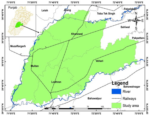
2.1. Study area
The research area was bordered by Southern Punjab (Multan division). Study area lies between longitude 71° 00′ 54″ E to 72° 58′ 43″ E and latitude 29° 27′ 21″ N to 30°45′ 30″ N approximately (). The study area has 4 districts which include Lodhran, Khanewal, Multan and Vehari Districts. Multan is known to be one of the oldest cities in Southern Punjab. Multan region lies at Nili Bar which is between Beaas, Sutluj and Ravi rivers. The region of Multan is plain and very productive with River of Chenab on western side (passing in District Muzaffargarh). This region is one of the most favored parts of the country from an agricultural aspect with land use/land cover (LULC) and human settlements. The region of Multan has one of the best cultivated areas which are suitable for various crops like wheat, rice, cotton sugarcane and maize. Multan is the 7th largest city with 4.7 M population in Pakistan. It is main economic and cultural Centre in Punjab, Pakistan. Economic of this area was based on agro-production but agriculture was dependent on canals as well as wells due to less rainfall.
Figure 1. Study area map of Multan division.
2.2. Datasets and software use
To identify the agriculture land suitability, eight thematic layers, namely, LULC, elevation, altitude, slope, soil type, soil pH and climatic data (rainfall and temperature) were considered. The climatic data (temperature and rainfall) were downloaded from website (http://power.larc.nasa.gov). The thematic map of LULC was generated from multi-spectral pan-sharpened Landsat 8 OLI with a spatial resolution of 30 m dated 14 March 2022 were used and the classification was carried out in ERDAS Imagine 2015 software (Hussain, Mubeen, Akram, et al., Citation2020). All the factor layers produced in ArcMap 10.6 with every layer were resized to 25 m × 25 m resolution and projected into Rectified Skew Orthomorphic (RSO). Buffer layers for soil texture and pH were also created. All the layers were then rasterized and after that reclassified in GIS as per their relative importance. The datasets used for the present investigation and their sources are listed in .
Table 1. List of all datasets and their sources.
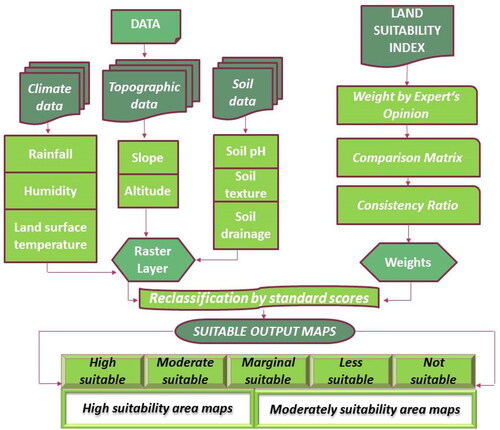
2.3. Analytical hierarchy process (AHP)
In the context of agricultural land suitability analysis, these MCDA methods (weighted sum, weighted product and fuzzy logic) were applied to integrate the standardized data from various criteria. For example, using the Weighted Sum Method, the standardized scores for soil quality, climate conditions, topography, water availability and other relevant criteria are multiplied by their respective weights and then summed to obtain an overall suitability score for each location (Kumar & Pant, Citation2023). The Weighted Product Method can be applied similarly but with multiplication instead of summation. Fuzzy logic can be used to handle linguistic variables and uncertainties associated with criteria like climate resilience or social factors. The choice of MCDA method depends on the nature of the decision problem, the characteristics of the criteria and the preferences of decision-makers. Each method has its strengths and limitations and the appropriateness of the chosen method should be carefully considered based on the specific requirements of the agricultural land suitability analysis (Hussain et al., Citation2024).
The variables LULC, elevation, Altitude, slope, soil type, soil pH and climatic data (rainfall and temperature) were used for the identification of land suitability analysis (Shahab et al., Citation2016). All the variables were either in the form of remote sensing imagery or in the form of excels tables which were later on transformed in GIS format. After running the AHP calculation on the data, all the layers were converted into a raster file format for further suitability analysis. Seventeen (17) points in different districts were marked through a GPS survey that shows the locations actually having this agriculture. Analytical Hierarchy Process (AHP) and extensively used MCDA technique developed by Saaty and Vargas (Citation2006) was considered to prioritize the criteria for land suitability analysis [59]. It is a technique for analyzing the supporting decisions with many and competing objectives, as well as multiple alternatives. A decision hierarchy is formed when a complex choice problem is broken into smaller decision problems (Khubaib et al., Citation2021; A. Naz & Rasheed, Citation2017; Syed & Shahida, Citation2010). To promote and accomplish optimal decisions, AHP integrates the decision-subjective maker’s judgments as well as empirical evidence (Aftab et al., Citation2011; Iqbal et al., Citation2021). Eight criteria were selected as inputs to the AHP exercise based on geo-environmental infrastructural and characteristics and then further used for the weighted overlay analysis in Arc Map (Rasheed & Naz, Citation2016; Waseem et al., Citation2020). Weights were assigned based on expert opinion and literature reviewed in this work, hence normalized weights of all criteria were tested for consistency ratio (CR) as indicated by Hassan et al. (Citation2020) using the formulas in EquationEquations (1–6).
Preparation of pairwise judgment matrices (X)
(1)
(1)
Where in EquationEquation (1)(1)
(1) ,
represents the criteria with
being the judgment matrix element.
2.3.1. Normalization of weights
where signifies the geometric mean of the ith row of judgment matrices generated using EquationEquation (3)
(3)
(3)
(3)
(3)
2.3.2. Checking the consistency ratio
Where CI exhibits consistency index computed from EquationEquation (5)(5)
(5)
(5)
(5)
In EquationEquation (5)(5)
(5) 𝜆max represents eigen value of the matrix M and was calculated using EquationEquation (6)
(6)
(6)
(6)
(6)
In EquationEquation (6)(6)
(6) , W denotes a weighted vector. The value of RCI (random consistency index) can be obtained from standard table given by Hassan et al. (Citation2020). The value ≤0.10 is acceptable for the consistency ratio (CR). The flow chart showing the methodological framework for the current research is shown in .
Figure 2. Flow chart of detail methodology.
3. Results
3.1. Soil texture
Soil texture is one of the most significant lithological factors that also affect agriculture land suitability. Soil plays an important role in restricting the movement of agriculture land suitability and the best soil type for agriculture selection is clay loam, followed by silty clay and sandy loam. In the present investigation, four soil classes were specified, which include clay loam, silty clay, sandy loam and clay sand as shown in . For agriculture location suitability, the most elevated weightage was allocated to clay loam unit, while the least preference was given to sandy loam ().
Figure 3. Map of soil texture, soil pH, elevation and altitude in Multan division.
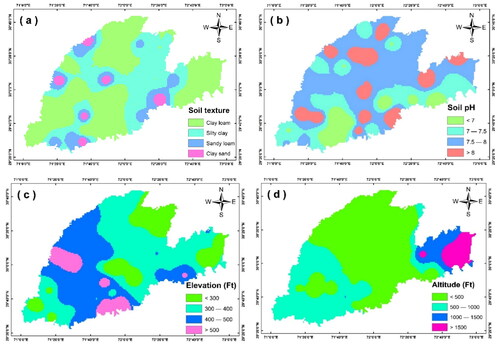
Table 2. Description and weights of soil texture, soil pH, elevation and altitude in Multan division.
3.2. Soil pH
Soil pH is also among the critical lithological factors in identifying the agriculture land suitability. Soil plays an important role in constrictive the suitability of agriculture and the best soil pH for agriculture is < 7. In the present study, 4 soil pH types were identified, which are < 7, 7–7.5, 7.5–8 and > 8 as shown in . For agriculture land suitability, the highest weightage was assigned to 7–8 and the least preference was given to >8 (). pH of soil increased due to increasing the built-up area and human activities.
3.3. Elevation
Elevation is considered as an influential topographical parameter in the selection of agricultural land. Greater elevation regions are not suitable for agriculture due to environmental decline. Elevation is prepared by using DEM in ArcMAP. In our research, the region was divided into 4 elevation zones < 300 Ft, 300–400 Ft, 400–500 Ft and >500 Ft (). Therefore, regions with higher elevations were given the least preference for agriculture, while regions with an elevation between 200 and 400 Ft were assigned the maximum weightage ().
3.4. Altitude
Altitude is regarded as another important topographical consideration during selection of agriculture land. High altitude areas are not suitable for the agriculture. Altitude is prepared by using DEM from contour map. The area was divided into 4 altitude zones < 500 Ft, 500–1000 Ft, 1000–1500 Ft and >1500 Ft, as shown in . Thus, areas with higher altitudes were given the least preference for agriculture, while areas with an elevation of between 300 and 1000 Ft assigned the maximum weightage ().
3.5. Temperature
Temperature is a pivotal climatic factor in the selection of agriculture land. Point data for the temperature was downloaded from NASA site and converted into GIS climate. The area was divided into four elevation zones < 27, 27–27.5, 27.5–28 and > 28, as shown in . High temperature areas are not suitable for the agriculture due to environmental deterioration. Thus, areas with higher temperatures (>28) were given the least preference for agriculture, while areas with a temperature <27.5 assigned the maximum weightage ().
Figure 4. Map of temperature, rainfall, slope and LULC in Multan region.
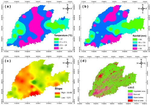
Table 3. Description and weights of temperature, rainfall, slope and LULC in Multan region.
3.6. Rainfall
Rainfall is another important climatic criterion for planning the agriculture. Point data for the rainfall was downloaded from NASA site and converted into GIS climate. High rainfall areas are highly suitable for the agriculture while the low rainfall area is least preference for agriculture. The area was divided into four rainfall sub-criteria < 100 mm, 100–125 mm, 125–150 mm and >150, as shown in . Thus, areas with less rainfall were given the least preference for agriculture, while areas with rainfall > 150 were given the greatest weightage ().
3.7. Slope
Slope is an essential geomorphological factor for agriculture land suitability. High slope degrees are normally not suitable for agriculture owing to increased drilling costs and deterioration factors. Percentage slope determines how steep or flat the surface is, higher the slope value means steeper the terrain and low the slope value flatter the terrain. Slope was extracted from DEM using spatial analyst tool through its raster surface analysis. In this assessment, slope layer was divided into four zones <15°, 15–30°, 30–45° and >40° (). Due to the above-mentioned assumptions, the highest preference was given to the areas having slope values <15 and lowest weightage was assigned to the areas with steeper slope values > 50 ().
3.8. LULC changes
In the present study, four LULC classes, namely, agriculture area, water bodies, bare soil and built-up area were identified (). Hence, the highest weightage was provided to the vegetated areas while the lowest weightage was provided to water bodies and build-ap land (). A supervised classification technique was used for LULC classes along with GIS software and additional information for the study area. In our study area, vegetation area was 153, 0629.88 ha (85.75%) followed by bare soil 42,587 ha (2.38%). Built-up area was 187,949.66 ha (10.53%), while the water bodies area was 239, 19.65 ha (1.32%) in Multan division (). The LULC is a vital element in understanding the interrelationship between anthropogenic activities and the environment. Therefore, local agriculture planners may assess past decisions using this knowledge, as well as gain insight into the potential impacts of their present decisions before they are introduced.
Table 4. Area distribution of LULC in Multan region.
3.9. Agriculture land suitability
The GIS based on the MCDA technique is useful for agriculture land suitability. Hence, eight factors were entered into the weighted overlay analysis and the conclusive obtained output is illustrated in . This output was classified into five classes, ie (a) highly suitable, (b) moderate suitable, (c) marginally suitable, (d) less suitable and (e) not suitable. The regions under these classes are given in . The majority of Multan division is classified as highly suitable for agriculture; with 765,106.73 ha (42.86%) classified as very high suitability. On the basis of the agriculture suitability index map, only a very high and moderate suitability class was selected for the agriculture activities. The high and moderate suitable areas were 765,106.73 ha (42.86%) and 473,827.24 ha (26.54%) respectively for the agriculture activities in the study area. The marginal and less suitable areas were 285,655.16 ha (16%) and 145,054.01 ha (8.13%) respectively for the agriculture activities in Multan division. Similarly, our analysis showed that 115,443.05 ha (6.47%) is not suitable for agriculture. Agriculture suitability should not be near roads to decrease harmful environmental effects and urban areas. Agriculture land suitability analysis is a very important approach by including the data from various domains for example crop and soil information, economics and social management, which have the main influence on the urban regions. Highly agriculture-suitable regions have no important limits for current cropping patterns, for example, main crops with potential of thorough agriculture, if irrigation is available. Moderately agriculture-suitable regions are also suitable for agriculture production but proper management is necessary.
Figure 5. Map of agriculture land suitability in study area.
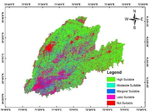
Table 5. Area distribution for agriculture land suitability in Multan region.
4. Discussion
In present research, agriculture land suitability analysis was carried out using the MCDA method, like (AHP) and weighted overlay analysis in a GIS tools. GIS based on MCDA technique is useful for agriculture land suitability. Asase and Peterson (Citation2019), has studied general physical conditions such as topography, elevation, aspect (orientation), LULC and Distance from woody biomass sources, factors. Secondly, costs include distance from railways, power lines, water bodies, sewer water treatment plants and community (Talib et al., Citation2019). The third group was of environmental impacts on Wildlife habitat/endangered species areas, wetland areas, flood plain and public land suitable for woody biomass-based ethanol plants. According to our study, the high and moderate suitable areas were 765,106.73 ha (42.86%) and 473,827.24 ha (26.54%), respectively, for the agriculture activities in study area. Highly agriculture suitable regions have no important limits for current cropping patterns, for example, main crops with potential of thorough agriculture.
Badr et al. (Citation2018) carried out a suitability analysis for determination of environmental factors and indicators for Crimean juniper plant species in Acipayam District, Turkey. The evaluated environmental variables were elevation, slope, radiation index, topographic position, landform characteristics and parent material and plant species. Considering the provincial physical and plant growing conditions, it was decided that soil type, climate conditions and topographic variables will be evaluated for the suitability criteria (Jamali et al., Citation2014). Conversely, various studies reported that less than 10% of the available reported literature on RS and agriculture fundamentally concentrate on cropping practices. This is fundamental for some, reasons, including the capacity to pose the correct inquiries and utilize the proper apparatuses and profundity of examination in noting them and the capacity to deliver final results that fulfill worldwide guidelines for cross-country correlations.
Zeraatpisheh et al. (Citation2017) reported the conventional and digital soil mapping approaches to predict soil classes in Iran. According to Hussain, Lu, et al. (Citation2022), Multan division is the most productive land for the vegetation areas. Hussain, Ahmad, et al. (Citation2020) stated that awareness and perception about climate change impacts have a major effect on farmers. Hussain, Mubeen, Ahmad, et al. (Citation2022) stated that climate change impacts can be measured from the perspectives of perception and awareness. The information about land cover and agro-ecological zone helps to identify the areas of change in a region land use for different crops. Geoinformatics allow an assignment of spatial implications to LULC changes, namely, population pressure, climate, terrain, etc. which is the driving forces of these changes (Chandio et al., Citation2011; Kabir et al., Citation2017). The processes of surface changes, identifying the characteristics and quantitative analysis can be analyzed from the various periods of RS data.
In Pakistan, where agriculture is a cornerstone of the economy, such analyses hold particular significance. By integrating diverse factors like soil quality, climate conditions, water availability and terrain characteristics, agricultural land suitability analysis provides valuable insights for farmers, policymakers and land managers. It guides crop selection, irrigation strategies and land-use planning, ultimately optimizing agricultural productivity while minimizing environmental impacts. Additionally, as climate change continues to pose challenges, these analyses help anticipate and adapt to shifting agricultural conditions, enhancing resilience in the face of evolving climate patterns. However, the success of such analyses hinges on reliable data, advanced technologies like GIS and remote sensing and effective community engagement to ensure that local knowledge and preferences are considered in decision-making. Appropriate utilization of fertilizer, furthermore, is considered an important function in increasing the productivity of vegetation and providing heightened yields (Singha et al., Citation2023). This can only be possible with an acceptable understanding of climatic features and by presenting attention to agriculturalists about the most suitable fertilizer according to temperature range of the cropping region (Alsafadi et al., Citation2023). Fertilizers at low prices should be available so that farmers can improve the productivity of the soil. Preparation of the field and choosing seeds tolerable to high temperatures is critical to get maximum yield. It was observed that simple methods for ploughing to shallow depth are used which is the reason for low yield because deep ploughing improves the growth and development of plants. The latest agricultural methods and machinery should be used to increase production. Hence, proper management of this vegetation cover, water resources and building area are necessary, because these valuable plant and water resources may soon be lost without proper management. These resources may stop playing the necessary role in agricultural production and the socio-economic development of the region.
5. Conclusion
The study aims to support decision-makers, land use planners and policymakers in making informed choices about the allocation of land resources for agricultural purposes. By integrating AHP and MCDA, the methodology seeks to enhance the precision and objectivity of the decision-making process, ultimately contributing to sustainable agricultural practices and land management. A number of environmental, topographical, lithological and socio-economic parameters were considered for the agriculture land suitability in Southern Punjab (Pakistan). The agriculture land suitability map indicated that the majority of the areas were highly suitable for agriculture purposes in Multan region. Only small patches were found not suitable for agricultural activities. Almost 43% of the studied land was highly suitable for agriculture, 27% moderately suitable, 16% marginally suitable, 8% less suitable and 6% was not suitable for agriculture in the studied area. Most of the identified suitable land sites were found under agricultural land use types and these sites lie in a vegetated area. All the suitable lands had silty clay or clay type soil texture. The present research also highlighted the usage of spatial analysis processes in GIS for selecting agricultural land. GIS has the capability to handle a large number of datasets of spatial and non-spatial data in a short period of time. In Pakistan, where agriculture plays a pivotal role in the economy and food security, the insights derived from land suitability analysis are invaluable. However, it is essential to continually update and refine these assessments, incorporating local knowledge and embracing technological advancements, to ensure their ongoing relevance and effectiveness in guiding responsible land use. As the global demand for food surges and environmental concerns intensify, agricultural land suitability analysis remains a crucial tool in achieving the dual objectives of agricultural prosperity and environmental sustainability. This study will give us future predictions and areas which could be used for agriculture. Finally, the federal government, local government and city planners can also use the results of this site selection analysis to guide and make future decisions. Extend the research to provide policy recommendations based on the identified suitable areas, helping policymakers in the formulation of land use policies that promote sustainable agriculture. As climate change continues to impact agricultural practices, future studies can incorporate climate change scenarios into the analysis. This would involve assessing the resilience of identified suitable areas to potential climate variations, ensuring that the land remains viable for agriculture in the long term.
Authors’ contributions
Conceptualization and supervision: SH, WN and MM; writing review and editing: SH, WN, SF, AT, HGA, SK and HA; data curation and formal analysis SH, WN, SF, AT, MM, SA, JM, HGA, SK and HA; evidence collection, review and editing: SH, WN, JM, SF, AT, HA, SK and HGA.
Acknowledgements
The authors extend their appreciation to the Deanship of Scientific Research at King Khalid University for funding this work through Research Group under grant number RGP1/440/44. The authors are also grateful to editors and potential reviewers.
Disclosure statement
No potential conflict of interest was reported by the author(s).
Data availability statement
The data that support the findings of this study are available on request from the corresponding author.
Additional information
Funding
Notes on contributors
Sajjad Hussain
Sajjad Hussain is PhD scholar in Department of Environmental Science, COMSATS University Islamabad, Vehari Campus. He published 20 research article in international journals (with more than 75 Impact Factor) and 20 book chapter in international books. My research interests are: Assessment of land surface temperature, land use land cover changes, Cropping pattern, NDVI, NDBI, urban planning and management using remote sensing, MODIS, sentinel as well as multi spectral remote sensing data.
Wajid Nasim
Wajid Nasim Jatoi serving Department of Agronomy, Faculty of Agriculture & Environment, The Islamia University of Bahawalpur (IUB), Pakistan since November 21, 2019. Before joining IUB, he served the Department of Environmental Sciences, COMSATS University Islamabad (Vehari Campus), Pakistan for 08 years, and Quaid-i-Azam University Islamabad, (Pakistan) for 01 year at different positions. He published more than 100 peer reviewed research publications (with more than 400 Impact Factor) and organized more than 50 national and international conferences/seminars/workshops and attended more than 50 national & international conferences/seminars/workshops as invited/keynote speaker, also write International book “Building Climate Resilience in Agriculture” as first editor published by Springer Nature.
Muhammad Mubeen
Dr. Muhammad Mubeen has been working as Assistant Professor at Department of Environmental Sciences, COMSATS University Islamabad, Vehari Campus (Pakistan) since July, 2014. His areas of interest include Agronomy, Climate change and Agro-meteorology, Crop Growth Modeling, Remote sensing and GIS and Water management. He has over 60 publications in national and international peer reviewed journals and books. He has expertise in Cropping system model “Decision Support System for Agro-technology Transfer (DSSAT) and GIS softwares (ArcGIS and ERDAS). He is reviewer of many national and international well-reputed journals. He is also editor of international book.
Shah Fahad
Dr. Shah Fahad is working as Assistant Professor in the Department of Agronomy, Abdul Wali Khan University Mardan, Khyber Pakhtunkhwa, Pakistan. He obtained his PhD in Agronomy from Huazhong Agriculture University, China, in 2015. After doing his postdoctoral research in Agronomy at the Huazhong Agriculture University (2015–17), he accepted the position of Assistant Professor at the University of Haripur. He has published over 450 peer-reviewed papers (Impact factor 2334.31) with more than 390 research and 60 review articles, on important aspects of climate change, plant physiology and breeding, plant nutrition, plant stress responses and tolerance mechanisms, and exogenous chemical priming-induced abiotic stress tolerance.
Aqil Tariq
Aqil Tariq received the Ph.D. degree in photogrammetry and remote sensing from the State Key Laboratory of Information Engineering in Surveying, Mapping, and Remote Sensing, Wuhan University, Wuhan, China, in 2021. He is currently with the Department of Wildlife, Fisheries and Aquaculture, Mississippi State University, Mississippi State, MS, USA. He is the author of more than 130 journal articles and conference proceedings papers. His research interests include photogrammetry, precision agriculture, 3-D geoinformation, urban analytics, spatial analysis to examine land use/land cover, geospatial data science, agriculture monitoring, natural hazards (forest fire, landslide, droughts, and flood) forest monitoring, forest cover dynamics, spatial statistics, multicriteria algorithms, ecosystem sustainability, hazards risk reduction, statistical analysis, and modeling using Python, R, and MATLAB.
Shankar Karuppannan
Shankar Karuppannan is an Associate Professor in the Department of Applied Geology, School of Applied Natural Sciences (SoANS), Adama Science and Technology, Adama, Ethiopia. He is a Distinguished Adjunct Professor at the Department of Research Analytics, Saveetha Institute of Medical and Technical Sciences (SIMATS), Saveetha University, Chennai-600077, Tamil Nadu, India. He has 15 years of experience in teaching and research. His research interests include hydrogeology, environmental pollution, geostatistics, remote sensing, and GIS applications to geology, water, soil, natural hazards, agrarian, and environmental resources. He is an active researcher and has published over 80 papers in peer-reviewed journals, 26 research papers presented at national and international conferences and seminars, 4 chapters in books, and 2 books.
Saeed Alqadhi
Dr. Saeed Alqadhi is a distinguished academic and researcher in the field of Civil Engineering, currently serving as the Dean at the College of Engineering, King Khalid University, Saudi Arabia. He earned his Ph.D. in Civil Engineering from Purdue University, USA, in 2018, and holds a Master of Science in Engineering Management from California State University, Northridge, USA. His professional journey includes roles as an Assistant Professor and lecturer in Civil Engineering at King Khalid University. His research interests encompass transportation planning and management, traffic safety, and econometric modeling. Dr. Alqadhi is also involved in consultancy work and serves on various academic committees and professional societies. He has authored numerous journal articles, conference papers, and book chapters, focusing on topics like transportation planning, traffic safety, and econometric modeling. His research projects cover a wide range of issues in civil engineering, including the impacts of highway maintenance, bridge surface maintenance, and landslide management using advanced technologies like deep learning and artificial intelligence. His work is characterized by a blend of practical engineering applications and innovative research methodologies.
Javed Mallick
Prof. Dr. Javed Mallick is a renowned Professor in the Department of Civil Engineering at King Khalid University, Saudi Arabia, specializing in Geoinformatics. He earned his Ph.D. from Jamia Millia Islamia, India, and his Master’s in Geoinformatics from ITC, The Netherlands. Dr. Mallick’s research focuses on environmental and hydrological studies, advanced remote sensing, GIS, and geostatistical analysis. He has an extensive publication record with 205 peer-reviewed papers and significant involvement in undergraduate, postgraduate, and research grant projects. Recognized for his excellence in teaching, academic development, and research, Dr. Mallick has received numerous institutional awards. He has also played key roles in quality coordination and academic assessment within his university and nationally, contributing notably to the field of urban and water informatics. His influential work has placed him among the “Top 2% Scientists in the world” in Geological & Geomatics Engineering, as listed by Stanford University for 2021 and 2022.
Hussein Almohamad
Dr. Hussein Almohamad received a PhD in Physical Geography from Justus Liebig University Giessen, Germany in 2009. He is a full professor at the Department of Geography, Qassim University, Saudi Arabia. His research interests include climatology, physical and human hazards, hydrology, data visualization and remote sensing.
Hazem Ghassan Abdo
Dr. Hazem Ghassan Abdo is a faculty member with a Ph.D. completed at the Geography Department, Tartous University, Syria. He earned his Ph.D. in Physical Gheography from Damascus University, Syria, in 2020, and holds a Master of Science in Physical Gheography from Tishreen University, Syria. His main research interests are the use of Remote Sensing and Geographic Information Systems for applications in the terrestrial environment to enhance the understanding of the Earth system processes, in the context of environmental and geomorphological shifts, which significantly interests him.
References
- AbdelRahman, M. A., Natarajan, A., & Hegde, R. (2016). Assessment of land suitability and capability by integrating remote sensing and GIS for agriculture in Chamarajanagar district, Karnataka, India. The Egyptian Journal of Remote Sensing and Space Science, 19(1), 1–17. https://doi.org/10.1016/j.ejrs.2016.02.001
- Abdullahi, S., & Pradhan, B. (2018). Land use change modeling and the effect of compact city paradigms: Integration of GIS-based cellular automata and weights-of-evidence techniques. Environmental Earth Sciences, 77(6), 1–15. https://doi.org/10.1007/s12665-018-7429-z
- Aftab, T., Shafiq, T., Khan, B., & Chaudhry, M. N. (2011). Physicochemical properties, contamination and suitability of canal water for irrigation, Lahore branch Pakistan. Pakistan Journal of Analytical & Environmental Chemistry, 12(1 & 2), 7.
- Afzal, S., Mubeen, M., Hussain, S., Ali, M., Javeed, H. M. R., Al-Ashkar, I., & Jatoi, W. N. (2023). Modern breeding approaches for climate change. In W. N. Jatoi, M. Mubeen, M. Z. Hashmi, S. Ali, S. Fahad, & K. Mahmood (Eds.), Climate change impacts on agriculture: concepts, issues and policies for developing countries (pp. 299–313). Springer International Publishing. https://doi.org/10.1007/978-3-031-26692-8_17
- Ahmed, G. B., Shariff, A. R. M., Balasundram, S. K., & bin Abdullah, A. F. (2016). Agriculture land suitability analysis evaluation based multi criteria and GIS approach [Paper presentation]. In W. N. Jatoi, M. Mubeen, A. Ahmad, M. A. Cheema, Z. Lin, M. Z. Hashmi (Eds.), IOP Conference Series: Earth Environment Science (Vol. 37, No. 1, p. 012044). IOP Publishing. https://doi.org/10.1088/1755-1315/37/1/012044
- Ahmed, M., Aslam, M. A., Hayat, R., Nasim, W., Akmal, M., Mubeen, M., & Ahmad, S. (2022). Nutrient dynamics and the role of modeling. In W. N. Jatoi, M. Mubeen, A. Ahmad, M. A. Cheema, Z. Lin, M. Z. Hashmi (Eds.), Building climate resilience in agriculture (pp. 297–316). https://doi.org/10.1007/978-3-030-79408-8_19
- Akpoti, K., Kabo-Bah, A. T., & Zwart, S. J. (2019). Agricultural land suitability analysis: State-of-the-art and outlooks for integration of climate change analysis. Agricultural Systems, 173, 172–208. https://doi.org/10.1016/j.agsy.2019.02.013
- Akram, R., Amanet, K., Iqbal, J., Fatima, M., Mubeen, M., Hussain, S., & Fahad, S. (2022). Climate change, insects and global food production. In Shah Fahad, Muhammad Adnan, Shah Saud, Lixiao Nie (Eds.), Climate change and ecosystems (pp. 47–60). CRC Press.
- Akram, R., Jabeen, T., Bukari, M. A., Wajid, S. A., Mubeen, M., Rasul, F., Hussain, S., Aurangzaib M., Bukhari, M. A., Hammad, H. M., Zamin, M., Habib ur Rahman, M., Iqbal, J., Rehmani, M. I. A., Tariq, M., Abbas, G., Mirza, N., Mubarak, H., Mahmood, F., Sajjad, M., Ali, S. & Nasim, W. (2022). Research on climate change issues. In W. N. Jatoi, M. Mubeen, A. Ahmad, M. A. Cheema, Z. Lin, & M. Z. Hashmi (Eds.), Building climate resilience in agriculture (pp. 255–268). Springer. https://doi.org/10.1007/978-3-030-79408-8_17
- Al-Hanbali, A., Shibuta, K., Alsaaideh, B., & Tawara, Y. (2022). Analysis of the land suitability for paddy fields in Tanzania using a GIS-based analytical hierarchy process. Geo-Spatial Information Science, 25(2), 212–228. https://doi.org/10.1080/10095020.2021.2004079
- Ali, A., Khan, M., Nadeem, M. A., Imran, M., Ahmad, S., Amanet, K., & Hanif, A. (2023). Climate change effects on the quality of different crop plants and coping mechanisms. In W. N. Jatoi, M. Mubeen, M. Z. Hashmi, S. Ali, S. Fahad, K. Mahmood (Eds.), Climate change impacts on agriculture: Concepts, issues and policies for developing countries (pp. 355–370). Springer International Publishing. https://doi.org/10.1007/978-3-031-26692-8_20
- Ali, M., Mubeen, M., Hussain, N., Wajid, A., Farid, H. U., Awais, M., Hussain, S., Akram, W., Amin, A., Akram, R., & Imran, M. (2019). Role of ICT in crop management. In M. Hasanuzzaman (Ed.), Agronomic crops (pp. 637–652). Springer. https://doi.org/10.1007/978-981-32-9783-8_28
- Alsafadi, K., Bi, S., Abdo, H. G., Almohamad, H., Alatrach, B., Srivastava, A. K., Al-Mutiry, M., Bal, S. K., Chandran, M. A. S., & Mohammed, S. (2023). Modeling the impacts of projected climate change on wheat crop suitability in semi-arid regions using the AHP-based weighted climatic suitability index and CMIP6. Geoscience Letters, 10(1), 1–21. https://doi.org/10.1186/s40562-023-00273-y
- Anusha, B. N., Babu, K. R., Kumar, B. P., Sree, P. P., Veeraswamy, G., Swarnapriya, C., & Rajasekhar, M. (2022). Integrated studies for land suitability analysis towards sustainable agricultural development in semi-arid regions of AP, India. Geosystems and Geoenvironment, 2(2), 100131. https://doi.org/10.1016/j.geogeo.2022.100131
- Asase, A., & Peterson, A. T. (2019). Predicted impacts of global climate change on the geographic distribution of an invaluable African medicinal plant resource, Alstoniaboonei De Wild. Journal of Applied Research on Medicinal and Aromatic Plants, 14, 100206. https://doi.org/10.1016/j.jarmap.2019.100206
- Aslam, A. Q., Ahmad, I., Ahmad, S. R., Hussain, Y., Hussain, M. S., Shamshad, J., & Zaidi, S. J. A. (2018). Integrated climate change risk assessment and evaluation of adaptation perspective in southern Punjab, Pakistan. The Science of the Total Environment, 628-629, 1422–1436. https://doi.org/10.1016/j.scitotenv.2018.02.129
- Aslam, A. Q., Ahmad, S. R., Ahmad, I., Hussain, Y., & Hussain, M. S. (2017). Vulnerability and impact assessment of extreme climatic event: A case study of southern Punjab, Pakistan. The Science of the Total Environment, 580, 468–481. https://doi.org/10.1016/j.scitotenv.2016.11.155
- Aymen, A. T., Al-Husban, Y., & Farhan, I. (2021). Land suitability evaluation for agricultural use using GIS and remote sensing techniques: The case study of Ma’an Governorate, Jordan. Egyptian Journal of Remote Sensing and Space Science, 24(1), 109–117. https://doi.org/10.1016/j.ejrs.2020.01.001
- Badr, G., Hoogenboom, G., Moyer, M., Keller, M., Rupp, R., & Davenport, J. (2018). Spatial suitability assessment for vineyard site selection based on fuzzy logic. Precision Agriculture, 19(6), 1027–1048. https://doi.org/10.1007/s11119-018-9572-7
- Bariotakis, M., Georgescu, L., Laina, D., Oikonomou, I., Ntagounakis, G., Koufaki, M.-I., Souma, M., Choreftakis, M., Zormpa, O. G., Smykal, P., Sourvinos, G., Lionis, C., Castanas, E., Karousou, R., & Pirintsos, S. A. (2019). From wild harvest towards precision agriculture: Use of Ecological Niche Modelling to direct potential cultivation of wild medicinal plants in Crete. The Science of the Total Environment, 694, 133681. https://doi.org/10.1016/j.scitotenv.2019.133681
- Chandio, I. A., Matori, A. N., Lawal, D. U., & Sabri, S. (2011). GIS-based land suitability analysis using AHP for public parks planning in Larkana City. Modern Applied Science, 5(4), 177. https://doi.org/10.5539/mas.v5n4p177
- Cheng, Y., Lan, S., Fan, X., Tjahjadi, T., Jin, S., & Cao, L. (2023). A dual-branch weakly supervised learning based network for accurate mapping of woody vegetation from remote sensing images. International Journal of Applied Earth Observation and Geoinformation, 124, 103499. https://doi.org/10.1016/j.jag.2023.103499
- Din, M. S. U., Mubeen, M., Hussain, S., Ahmad, A., Hussain, N., Ali, M. A., & Nasim, W. (2022). World Nations priorities on climate change and food security. In W. N. Jatoi, M. Mubeen, A. Ahmad, M. A. Cheema, Z. Lin, M. Z. Hashmi (Eds.), Building climate resilience in agriculture (pp 365–384). https://doi.org/10.1007/978-3-030-79408-8_22
- Elsheikh, R., Shariff, A. R. B. M., Amiri, F., Ahmad, N. B., Balasundram, S. K., & Soom, M. A. M. (2013). Agriculture Land Suitability Evaluator (ALSE): A decision and planning support tool for tropical and subtropical crops. Computers and Electronics in Agriculture, 93, 98–110. https://doi.org/10.1016/j.compag.2013.02.003
- Gilani, H., Goheer, M. A., Ahmad, H., & Hussain, K. (2020). Under predicted climate change: Distribution and ecological niche modelling of six native tree species in Gilgit-Baltistan, Pakistan. Ecological Indicators, 111, 106049. https://doi.org/10.1016/j.ecolind.2019.106049
- Griffel, L. M., Toba, A. L., Paudel, R., Lin, Y., Hartley, D. S., & Langholtz, M. (2022). A multi-criteria land suitability assessment of field allocation decisions for switchgrass. Ecological Indicators, 136, 108617. https://doi.org/10.1016/j.ecolind.2022.108617
- Hassan, I., Javed, M. A., Asif, M., Luqman, M., Ahmad, S. R., Ahmad, A., & Hussain, B. (2020). Weighted overlay based land suitability analysis of agriculture land in Azad Jammu and Kashmir using GIS and AHP. Pakistan Journal of Agricultural Sciences, 57(6), 1509–1519.
- He, M.-Y., Ren, T. X., Jin, Z. D., Deng, L., Liu, H. J., Cheng, Y. Y., Li, Z. Y., Liu, X. X., Yang, Y., & Chang, H. (2023). Precise analysis of potassium isotopic composition in plant materials by multi-collector inductively coupled plasma mass spectrometry. Spectrochimica Acta Part B: Atomic Spectroscopy, 209, 106781. https://doi.org/10.1016/j.sab.2023.106781
- Hu, Y., Raza, A., Syed, N. R., Acharki, S., Ray, R. L., Hussain, S., Dehghanisanij, H., Zubair, M., & Elbeltagi, A. (2023). Land use/land cover change detection and NDVI estimation in Pakistan’s Southern Punjab Province. Sustainability, 15(4), 3572. https://doi.org/10.3390/su15043572
- Hussain, S., Ahmad, A., Wajid, A., Khaliq, T., Hussain, N., Mubeen, M., Farid, H. U., Imran, M., Hammad, H. M., Awais, M., Ali, A., Aslam, M., Amin, A., Akram, R., Amanet, K., & Nasim, W. (2020). Irrigation scheduling for cotton cultivation. In S. Ahmad, & M. Hasanuzzaman (Eds.), Cotton production and uses (pp. 59–80). Springer. https://doi.org/10.1007/978-981-15-1472-2_5
- Hussain, S., Amin, A., Mubeen, M., Khaliq, T., Shahid, M., Hammad, H. M., & Nasim, W. (2022). Climate smart agriculture (CSA) technologies. In W. N. Jatoi, M. Mubeen, A. Ahmad, M. A. Cheema, Z. Lin, M. Z. Hashmi (Eds.), Building climate resilience in agriculture (pp 319–338). https://doi.org/10.1007/978-3-030-79408-8_20
- Hussain, S., & Karuppannan, S. (2021). Land use/land cover changes and their impact on land surface temperature using remote sensing technique in district Khanewal, Punjab Pakistan. Geology, Ecology, and Landscapes, 7(1), 46–58. https://doi.org/10.1080/24749508.2021.1923272
- Hussain, S., Lu, L., Mubeen, M., Nasim, W., Karuppannan, S., Fahad, S., Tariq, A., Mousa, B. G., Mumtaz, F., & Aslam, M. (2022). Spatiotemporal variation in land use land cover in the response to local climate change using multispectral remote sensing data. Land, 11(5), 595. https://doi.org/10.3390/land11050595
- Hussain, S., Mubeen, M., Ahmad, A., Akram, W., Hammad, H. M., Ali, M., Masood, N., Amin, A., Farid, H. U., Sultana, S. R., Fahad, S., Wang, D., & Nasim, W. (2020). Using GIS tools to detect the land use/land cover changes during forty years in Lodhran District of Pakistan. Environmental Science and Pollution Research International, 27(32), 39676–39692. https://doi.org/10.1007/s11356-019-06072-3
- Hussain, S., Mubeen, M., Ahmad, A., Fahad, S., Nasim, W., Hammad, H. M., Shah, G. M., Murtaza, B., Tahir, M., & Parveen, S. (2021). Using space–time scan statistic for studying the effects of COVID-19 in Punjab, Pakistan: A guideline for policy measures in regional agriculture. Environmental Science and Pollution Research, 30(15), 42495–42508. https://doi.org/10.1007/s11356-021-17433-2
- Hussain, S., Mubeen, M., Ahmad, A., Majeed, H., Qaisrani, S. A., Hammad, H. M., Amjad, M., Ahmad, I., Fahad, S., Ahmad, N., & Nasim, W. (2022). Assessment of land use/land cover changes and its effect on land surface temperature using remote sensing techniques in Southern Punjab, Pakistan. Environmental Science and Pollution Research International, 30(44), 99202–99218. https://doi.org/10.1007/s11356-022-21650-8
- Hussain, S., Mubeen, M., Ahmad, A., Masood, N., Hammad, H. M., Amjad, M., Imran, M., Usman, M., Farid, H. U., Fahad, S., Nasim, W., Javeed, H. M. R., Ali, M., Qaisrani, S. A., Farooq, A., Khalid, M. S., & Waleed, M. (2021). Satellite-based evaluation of temporal change in cultivated land in Southern Punjab (Multan region) through dynamics of vegetation and land surface temperature. Open Geosciences, 13(1), 1561–1577. https://doi.org/10.1515/geo-2020-0298
- Hussain, S., Mubeen, M., Akram, W., Ahmad, A., Habib-Ur-Rahman, M., Ghaffar, A., Amin, A., Awais, M., Farid, H. U., Farooq, A., & Nasim, W. (2020). Study of land cover/land use changes using RS and GIS: A case study of Multan district, Pakistan. Environmental Monitoring and Assessment, 192(1), 2. https://doi.org/10.1007/s10661-019-7959-1
- Hussain, S., Mubeen, M., Jatoi, W. N., Tahir, M., Ahmad, S., Farid, H. U., & Abbas, B. (2023). Sustainable development goals and governments’ roles for social protection. In W. N. Jatoi, M. Mubeen, M. Z. Hashmi, S. Ali, S. Fahad, & K. Mahmood (Eds.), Climate change impacts on agriculture: Concepts, issues and policies for developing countries (pp. 209–222). Springer International Publishing. https://doi.org/10.1007/978-3-031-26692-8_12
- Hussain, S., Mubeen, M., & Karuppannan, S. (2022). Land use and land cover (LULC) change analysis using TM, ETM + and OLI Landsat images in district of Okara, Punjab, Pakistan. Physics and Chemistry of the Earth, Parts A/B/C, 126, 103117. https://doi.org/10.1016/j.pce.2022.103117
- Hussain, S., Mubeen, M., Nasim, W., Fahad, S., Ali, M., Ehsan, M. A., & Raza, A. (2023). Investigation of irrigation water requirement and evapotranspiration for water resources management in Southern Punjab, Pakistan. Sustainability, 15(3), 1768. https://doi.org/10.3390/su15031768
- Hussain, S., Mubeen, M., Nasim, W., Mumtaz, F., Abdo, H. G., Mostafazadeh, R., & Fahad, S. (2024). Assessment of future prediction of urban growth and climate change in district Multan, Pakistan using CA-Markov method. Urban Climate, 53, 101766. https://doi.org/10.1016/j.uclim.2023.101766
- Hussain, S., Mubeen, M., Sultana, S. R., Ahmad, A., Fahad, S., Nasim, W., Ahmad, S., Ali, A., Farid, H. U., Javeed, H. M., & Sabagh, A. E. (2022). Managing greenhouse gas emission. In N. Sarwar, Atique-Ur-Rehman, S. Ahmad, & M. Hasanuzzaman (Eds.), Modern techniques of rice crop production (pp. 547–564). Springer. https://doi.org/10.1007/978-981-16-4955-4_27
- Hussain, S., Qin, S., Nasim, W., Bukhari, M. A., Mubeen, M., Fahad, S., Raza, A., Abdo, H. G., Tariq, A., Mousa, B. G., Mumtaz, F., & Aslam, M. (2022). Monitoring the dynamic changes in vegetation cover using spatio-temporal remote sensing data from 1984 to 2020. Atmosphere, 13(10), 1609. https://doi.org/10.3390/atmos13101609
- Hussain, S., Raza, A., Abdo, H. G., Mubeen, M., Tariq, A., Nasim, W., Majeed, M., Almohamad, H., & Al Dughairi, A. A. (2023). Relation of land surface temperature with different vegetation indices using multi-temporal remote sensing data in Sahiwal region, Pakistan. Geoscience Letters, 10(1), 33. https://doi.org/10.1186/s40562-023-00287-6
- Iqbal, J., Su, C., Rashid, A., Yang, N., Baloch, M. Y. J., Talpur, S. A., Ullah, Z., Rahman, G., Rahman, N. U., Earjh, E., & Sajjad, M. M. (2021). Hydrogeochemical assessment of groundwater and suitability analysis for domestic and agricultural utility in Southern Punjab, Pakistan. Water, 13(24), 3589. https://doi.org/10.3390/w13243589
- Islam, M. S., Fahad, S., Hossain, A., Chowdhury, M. K., Iqbal, M. A., Dubey, A., & Sabagh, A. E. (2021). Legumes under drought stress: Plant responses, adaptive mechanisms, and management strategies in relation to nitrogen fixation. In Shah Fahad, Osman Sönmez, Shah Saud, Depeng Wang, Chao Wu, Muhammad Adnan, & Muhammad Arif, Amanullah (Eds.), Engineering tolerance in crop plants against abiotic stress (pp 179–207). CRC Press.
- Jamali, I. A., Mörtberg, U., Olofsson, B., & Shafique, M. (2014). A spatial multi-criteria analysis approach for locating suitable sites for construction of subsurface dams in Northern Pakistan. Water Resources Management, 28(14), 5157–5174. https://doi.org/10.1007/s11269-014-0800-2
- Jiao, Y., Zhu, G., Meng, G., Lu, S., Qiu, D., Lin, X., Li, R., Wang, Q., Chen, L., Zhao, L., Yang, J., & Sun, N. (2023). Estimating non-productive water loss in irrigated farmland in arid oasis regions: Based on stable isotope data. Agricultural Water Management, 289, 108515. https://doi.org/10.1016/j.agwat.2023.108515
- Kabir, M., Hameed, S., Ali, H., Bosso, L., Din, J. U., Bischof, R., Redpath, S., & Nawaz, M. A. (2017). Habitat suitability and movement corridors of grey wolf (Canis lupus) in Northern Pakistan. PLoS One, 12(11), e0187027. https://doi.org/10.1371/journal.pone.0187027
- Karuppasamy, M. B., Natesan, U., Karuppannan, S., Chandrasekaran, L. N., Hussain, S., Almohamad, H., Dughairi, A. A. A., Al-Mutiry, M., Alkayyadi, I., & Abdo, H. G. (2022). Multivariate urban air quality assessment of indoor and outdoor environments at chennai metropolis in South India. Atmosphere, 13(10), 1627. https://doi.org/10.3390/atmos13101627
- Kazmi, D. H., Afzaal, M., Mubeen, M., Hussain, S., & Jatoi, W. N. (2023). Unpredictable weather and agriculture-based economy of developing countries. In W. N. Jatoi, M. Mubeen, M. Z. Hashmi, S. Ali, S. Fahad, & K. Mahmood (Eds.), Climate change impacts on agriculture: Concepts, issues and policies for developing countries (pp. 65–78). Springer International Publishing. https://doi.org/10.1007/978-3-031-26692-8_4
- Khaliq, M. A., Javed, M. T., & Hussain, S. (2022). Assessment of heavy metal accumulation and health risks in okra (Abelmoschus esculentus L.) and spinach (Spinacia oleracea L.) fertigated with wastwater. Food Contamination, 9, 11. https://doi.org/10.1186/s40550-022-00097-2
- Khan, D., Raziq, A., Young, H. W. V., Sardar, T., & Liou, Y. A. (2022). Identifying potential sites for rainwater harvesting structures in Ghazi Tehsil, Khyber Pakhtunkhwa, Pakistan, using geospatial approach. Remote Sensing, 14(19), 5008. https://doi.org/10.3390/rs14195008
- Khan, M. A., Ahmad, R., & Khan, H. H. (2022). Multi-criteria land suitability analysis for agriculture using AHP and remote sensing data of northern region India. In Yuanzhi Zhang & Qiuming Cheng (Eds.), Geographic information systems and applications in coastal studies (pp. 1–25). IntechOpen. https://www.intechopen.com/online-first/80925
- Khan, R., Li, H., Basir, M., Chen, Y. L., Sajjad, M. M., Haq, I. U., & Hassan, W. (2022). Monitoring land use land cover changes and its impacts on land surface temperature over Mardan and Charsadda Districts, Khyber Pakhtunkhwa (KP), Pakistan. Environment Monitoring and Assessment, 194(6), 1–22.
- Khan, S. M., Ullah, S., Sun, T., Rehman, A. U., & Chen, L. (2020). Land-use/land-cover changes and its contribution to urban heat island: A case study of Islamabad, Pakistan. Sustainability, 12(9), 3861. https://doi.org/10.3390/su12093861
- Khubaib, N., Asad, S. A., Khalil, T., Baig, A., Atif, S., Umar, M., Kropp, J. P., Pradhan, P., & Baig, S. (2021). Predicting areas suitable for wheat and maize cultivation under future climate change scenarios in Pakistan. Climate Research, 83, 15–25. https://doi.org/10.3354/cr01631
- Kumar, A., Garg, P., Pant, S., Ram, M., & Kumar, A. (2022). Multi-criteria decision-making techniques for complex decision making problems. Mathematics in Engineering, Science & Aerospace (MESA), 13(2), 791.
- Kumar, A., & Pant, S. (2023). Analytical hierarchy process for sustainable agriculture: An overview. MethodsX, 10, 101954. https://doi.org/10.1016/j.mex.2022.101954
- Kumar, A., Vohra, M., Pant, S., & Singh, S. K. (2021). Optimization techniques for petroleum engineering: A brief review. International Journal of Modelling and Simulation, 41(5), 326–334. https://doi.org/10.1080/02286203.2021.1983074
- Li, W., Wang, C., Liu, H., Wang, W., Sun, R., Li, M., Shi, Y., Zhu, D., Du, W., Ma, L., & Fu, S. (2023). Fine root biomass and morphology in a temperate forest are influenced more by canopy water addition than by canopy nitrogen addition. Frontiers in Ecology and Evolution, 11, 11. https://doi.org/10.3389/fevo.2023.1132248
- Luo, J., Zhao, C., Chen, Q., & Li, G. (2022). Using deep belief network to construct the agricultural information system based on Internet of Things. The Journal of Supercomputing, 78(1), 379–405. https://doi.org/10.1007/s11227-021-03898-y
- Majeed, M., Tariq, A., Anwar, M. M., Khan, A. M., Arshad, F., Mumtaz, F., Farhan, M., Zhang, L., Zafar, A., Aziz, M., Abbasi, S., Rahman, G., Hussain, S., Waheed, M., Fatima, K., & Shaukat, S. (2021). Monitoring of land use–land cover change and potential causal factors of climate change in Jhelum District, Punjab, Pakistan, through GIS and multi-temporal satellite data. Land, 10(10), 1026. https://doi.org/10.3390/land10101026
- Masood, N., Akram, R., Fatima, M., Mubeen, M., Hussain, S., Shakeel, M., & Nasim, W. (2022). Insect pest management under climate change. In W. N. Jatoi, M. Mubeen, A. Ahmad, M. A. Cheema, Z. Lin, & M. Z. Hashmi (Eds.), Building climate resilience in agriculture (pp. 225–237). Springer. https://doi.org/10.1007/978-3-030-79408-8_15
- Mubeen, M., Bano, A., Ali, B., Islam, Z. U., Ahmad, A., Hussain, S., Fahad, S., & Nasim, W. (2021). Effect of plant growth promoting bacteria and drought on spring maize (Zea mays L.). Pakistan Journal of Botany, 53(2), 731–739. https://doi.org/10.30848/PJB2021-2(38)
- Mubeen, M., Shabbir, K., Hanif, A., Ali, M., Hussain, S., & Ahmad, S. (2023). Role of environmental science for disaster risk reduction in agriculture. In M. Ahmed, & S. Ahmad (Eds.), Disaster risk reduction in agriculture (pp. 131–145). Springer Nature Singapore. https://doi.org/10.1007/978-981-99-1763-1_7
- Naz, A., & Rasheed, H. (2017). Modeling the rice land suitability using GIS and multi-criteria decision analysis approach in Sindh, Pakistan. Journal of Basic & Applied Sciences, 13, 26–33.
- Naz, S., Fatima, Z., Iqbal, P., Khan, A., Zakir, I., Ullah, H., & Ahmad, S. (2022). An introduction to climate change phenomenon. In W. N. Jatoi, M. Mubeen, A. Ahmad, M. A. Cheema, Z. Lin, & M. Z. Hashmi (Eds.), Building climate resilience in agriculture (pp. 3–16). Springer. https://doi.org/10.1007/978-3-030-79408-8_1
- Nguyen, H., Nguyen, T., Hoang, N., Bui, D., Vu, H., & Van, T. (2020). The application of LSE software: A new approach for land suitability evaluation in agriculture. Computers and Electronics in Agriculture, 173, 105440. https://doi.org/10.1016/j.compag.2020.105440
- Pant, S., Garg, P., Kumar, A., Ram, M., Kumar, A., Sharma, H. K., & Klochkov, Y. (2023). AHP-based multi-criteria decision-making approach for monitoring health management practices in smart healthcare system. International Journal of System Assurance Engineering and Management, 1–12. https://doi.org/10.1007/s13198-023-01904-5
- Pant, S., Kumar, A., Ram, M., Klochkov, Y., & Sharma, H. K. (2022). Consistency indices in analytic hierarchy process: A review. Mathematics, 10(8), 1206. https://doi.org/10.3390/math10081206
- Purnamasari, R. A., Noguchi, R., & Ahamed, T. (2022). Land suitability assessment for cassava production in Indonesia using GIS, remote sensing, and multi-criteria analysis. In T. Ahamed (Ed.), Remote sensing application (pp. 99–132). Springer.
- Rasheed, H., & Naz, N. (2016). Modeling the land suitability using GIS and AHP for cotton cultivation in Punjab, Pakistan: Modeling the land for cotton cultivation. Pakistan Journal of Scientific & Industrial Research Series A: Physical Sciences, 59(2), 96–108. https://doi.org/10.52763/PJSIR.PHYS.SCI.59.2.2016.96.108
- Rawat, S. S., Pant, S., Kumar, A., Ram, M., Sharma, H. K., & Kumar, A. (2022). A state-of-the-art survey on analytical hierarchy process applications in sustainable development. International Journal of Mathematical, Engineering and Management Sciences, 7(6), 883–917. https://doi.org/10.33889/IJMEMS.2022.7.6.056
- Raza, A., Syed, N. R., Fahmeed, R., Acharki, S., Hussain, S., Zubair, M., Almohamad, H., Alao, J. O., Rahman, M. N., & Abdo, H. G. (2023). Land use/land change detection and determination of land surface temperature variation in green belt (Nasirabad) district of Balochistan, Pakistan. SN Applied Sciences, 5(11), 297. https://doi.org/10.1007/s42452-023-05520-7
- Saaty, T. L., & Vargas, L. G. (2006). Decision making with the ANP. Omega, 15(4).
- Sabagh, A. E., Hossain, A., Islam, M. S., Iqbal, M. A., Fahad, S., Ratnasekera, D., & Llanes, A. (2020). Consequences and mitigation strategies of heat stress for sustainability of soybean (Glycine max L. Merr.) production under the changing climate. In Akbar Hossain (Ed.), Plant stress physiology (pp. 1–22). IntechOpen.
- Sekhar, S., Dutta, S., Sahana, M., Areendran, G., & Raj, K. (2022). Assessing impact of climate variability on potential agricultural land suitability in Nalanda District, Bihar. In Azizur Rahman Siddiqui, & Avijit Sahay (Eds.), Climate change, disaster and adaptations (pp. 131–149). Springer.
- Seyedmohammadi, J., & Navidi, M. N. (2022). Applying fuzzy inference system and analytic network process based on GIS to determine land suitability potential for agricultural. Environmental Monitoring and Assessment, 194(10), 712. https://doi.org/10.1007/s10661-022-10327-x
- Shahab, A., Shihua, Q., Rashid, A., Hasan, F. U., & Sohail, M. T. (2016). Evaluation of water quality for drinking and agricultural suitability in the Lower Indus Plain in Sindh Province, Pakistan. Polish Journal of Environmental Studies, 25(6), 2563–2574. https://doi.org/10.15244/pjoes/63777
- Shang, K., Xu, L., Liu, X., Yin, Z., Liu, Z., Li, X., Yin, L., & Zheng, W. (2023). Study of urban heat island effect in Hangzhou Metropolitan Area based on SW-TES algorithm and image dichotomous model. SAGE Open, 13(4), 1–20. https://doi.org/10.1177/21582440231208851
- Singha, C., Chandra Swain, K., Sahoo, S., Ghassan Abdo, H., Almohamad, H., Abdullah Al Dughairi, A., & Albanai, J. A. (2023). Total land suitability analysis for rice and potato crops through FuzzyAHP technique in West Bengal, India. Cogent Food & Agriculture, 9(1), 2257975. https://doi.org/10.1080/23311932.2023.2257975
- Syed, M. A. R., & Shahida, H. (2010). Land suitability classification of choice of trees species in District Rahim Yar Khan, Punjab, Pakistan. African Journal of Agricultural Research, 5(23), 3219–3229.
- Talib, M. A., Tang, Z., Shahab, A., Siddique, J., Faheem, M., & Fatima, M. (2019). Hydrogeochemical characterization and suitability assessment of groundwater: A case study in Central Sindh, Pakistan. International Journal of Environmental Research and Public Health, 16(5), 886. https://doi.org/10.3390/ijerph16050886
- Tariq, A., & Mumtaz, F. (2022). Modeling spatio-temporal assessment of land use land cover of Lahore and its impact on land surface temperature using multi-spectral remote sensing data. Environmental Science and Pollution Research, 30(9), 23908–23924. https://doi.org/10.1007/s11356-022-23928-3
- Tariq, A., Mumtaz, F., Majeed, M., & Zeng, X. (2023). Spatio-temporal assessment of land use land cover based on trajectories and cellular automata Markov modelling and its impact on land surface temperature of Lahore district Pakistan. Environmental Monitoring and Assessment, 195(1), 114. https://doi.org/10.1007/s10661-022-10738-w
- Tariq, S., Mubeen, M., Hammad, H. M., Jatoi, W. N., Hussain, S., Farid, H. U., & Fahad, S. (2023). Mitigation of climate change through carbon farming. In W. N. Jatoi, M. Mubeen, M. Z. Hashmi, S. Ali, S. Fahad, & K. Mahmood (Eds.), Climate change impacts on agriculture: Concepts, issues and policies for developing countries (pp. 381–391). Springer International Publishing. https://doi.org/10.1007/978-3-031-26692-8_22
- Tian, H., Huang, N., Niu, Z., Qin, Y., Pei, J., & Wang, J. (2019). Mapping winter crops in China with multi-source satellite imagery and phenology-based algorithm. Remote Sensing, 11(7), 820. https://doi.org/10.3390/rs11070820
- Tian, H., Pei, J., Huang, J., Li, X., Wang, J., Zhou, B., Qin, Y., & Wang, L. (2020). Garlic and winter wheat identification based on active and passive satellite imagery and the google earth engine in Northern China. Remote Sensing, 12(21), 3539. https://doi.org/10.3390/rs12213539
- Vincent, D. R., Deepa, N., Elavarasan, D., Srinivasan, K., Chauhdary, S. H., & Iwendi, C. (2019). Sensors driven AI-based agriculture recommendation model for assessing land suitability. Sensors, 19(17), 3667. https://doi.org/10.3390/s19173667
- Waleed, M., Mubeen, M., Ahmad, A., Habib-Ur-Rahman, M., Amin, A., Farid, H. U., Hussain, S., Ali, M., Qaisrani, S. A., Nasim, W., Javeed, H. M. R., Masood, N., Aziz, T., Mansour, F., & EL Sabagh, A. (2022). Evaluating the efficiency of coarser to finer resolution multispectral satellites in mapping paddy rice fields using GEE implementation. Scientific Reports, 12(1), 13210. https://doi.org/10.1038/s41598-022-17454-y
- Waseem, M., Khan, B., Mahmood, T., Hussain, H. S., Aziz, R., Akrim, F., Ahmad, T., Nazir, R., Wajid Ali, M., & Awan, M. N. (2020). Occupancy, habitat suitability and habitat preference of endangered indian pangolin (Manis crassicaudata) in Potohar Plateau and Azad Jammu and Kashmir, Pakistan. Global Ecology and Conservation, 23, e01135. https://doi.org/10.1016/j.gecco.2020.e01135
- Wu, X., Feng, X., Wang, Z., Chen, Y., & Deng, Z. (2023). Multi-source precipitation products assessment on drought monitoring across global major river basins. Atmospheric Research, 295, 106982. https://doi.org/10.1016/j.atmosres.2023.106982
- Yalew, S. G., Van Griensven, A., Mul, M. L., & van der Zaag, P. (2016). Land suitability analysis for agriculture in the Abbay basin using remote sensing, GIS and AHP techniques. Modeling Earth Systems and Environment, 2(2), 1–14. https://doi.org/10.1007/s40808-016-0167-x
- Yang, X., Yang, Q., Zhu, H., Wang, L., Wang, C., Pang, G., Du, C., Mubeen, M., Waleed, M., & Hussain, S. (2023). Quantitative evaluation of soil water and wind erosion rates in Pakistan. Remote Sensing, 15(9), 2404. https://doi.org/10.3390/rs15092404
- Zahoor, S. A., Ahmad, S., Ahmad, A., Wajid, A., Khaliq, T., Mubeen, M., Hussain, S., Din, M. S. U., Amin, A., Awais, M., & Nasim, W. (2019). Improving water use efficiency in agronomic crop production. In M. Hasanuzzaman (Ed.), Agronomic crops (pp. 13–29). Springer. https://doi.org/10.1007/978-981-32-9783-8_2
- Zeraatpisheh, M., Ayoubi, S., Jafari, A., & Finke, P. (2017). Comparing the efficiency of digital and conventional soil mapping to predict soil types in a semi-arid region in Iran. Geomorphology, 285, 186–204. https://doi.org/10.1016/j.geomorph.2017.02.015
- Zhang, P., Liu, L., Yang, L., Zhao, J., Li, Y., Qi, Y., Ma, X., & Cao, L. (2023). Exploring the response of ecosystem service value to land use changes under multiple scenarios coupling a mixed-cell cellular automata model and system dynamics model in Xi’an, China. Ecological Indicators, 147, 110009. https://doi.org/10.1016/j.ecolind.2023.110009
- Zhao, M., Zhou, Y., Li, X., Cheng, W., Zhou, C., Ma, T., Li, M., & Huang, K. (2020). Mapping urban dynamics (1992–2018) in Southeast Asia using consistent nighttime light data from DMSP and VIIRS. Remote Sensing of Environment, 248, 111980. https://doi.org/10.1016/j.rse.2020.111980
- Zheng, H., Fan, X., Bo, W., Yang, X., Tjahjadi, T., & Jin, S. (2023). A multiscale point-supervised network for counting maize tassels in the wild. Plant Phenomics, 5, 0100. https://doi.org/10.34133/plantphenomics.0100
- Zhu, G., Liu, Y., Shi, P., Jia, W., Zhou, J., Liu, Y., Ma, X., Pan, H., Zhang, Y., Zhang, Z., Sun, Z., Yong, L., & Zhao, K. (2022). Stable water isotope monitoring network of different water bodies in Shiyang River basin, a typical arid river in China. Earth System Science Data, 14(8), 3773–3789. https://doi.org/10.5194/essd-14-3773-2022
- Zolekar, R. B., & Bhagat, V. S. (2015). Multi-criteria land suitability analysis for agriculture in hilly zone: Remote sensing and GIS approach. Computers and Electronics in Agriculture, 118, 300–321. https://doi.org/10.1016/j.compag.2015.09.016