
 ?Mathematical formulae have been encoded as MathML and are displayed in this HTML version using MathJax in order to improve their display. Uncheck the box to turn MathJax off. This feature requires Javascript. Click on a formula to zoom.
Abstract
The cycle of food insecurity caused by poor water management practices poses major concerns for the sustainability of living balance in Southwestern Ethiopia’s smallholder agricultural areas. The prior study looked at crop land suitability assessments. However, there are still knowledge gaps on irrigation infrastructure sites. As a result, this research was launched to evaluate the surface water irrigation (SWI) potential of river watersheds in the Gomma area, southwestern Ethiopia. To identify possible SWI, biophysical parameters such as topography, stream order, soil texture, land use-land cover, drainage density, and climate elements were analyzed. Potential SWI sites were identified using multiple-criteria decision-making analysis from the sources of information reviewed, which were applied for selecting suitable sites. A comparison matrix, weighted analysis, Boolean-operations, and survey approaches. The analysis findings reveal that about 16% of the Gomma is highly suitable (S1) for drip or sprinkler surface water irrigation (SWI) schemes, while 7% and 77% of the total fall under the categories of moderate and unsuitable for SWI, respectively. At the catchment level, the most irrigable catchments in Didessa, Naso, Awetu, Tamsa, and Urgessa were found to be approximately 1838, 1626, 1484, 1107, and 910 ha of total area, respectively. In contrast to prior outcomes, the eventual eligibility map of foreseeable SWI zones are squarely distributed over the study region. In conclusion, to optimize the impact on agricultural productivity and water resource management, it is advised to prioritize the implementation of drip or sprinkler surface water irrigation (SWI) schemes in areas identified as highly suitable.
Reviewing Editor:
1. Introduction
Irrigation is now attracting a lot of attention for reasons other than its financial and economic benefits. At the global level, agricultural irrigation, particularly surface water irrigation (SWI), most likely ensures food security and sustaining crop yields, combating the challenges posed by insufficient precipitation during the growing season (Foley et al., Citation2011; Guan et al., Citation2019; Li et al., Citation2021; Oulmane et al., Citation2022; Rahman et al., Citation2023; Tercan & Dereli, Citation2020). Yet, an increase in population has resulted in intense demand for global aquatic assets. In this regard, the global inhabitant is anticipated to surpass 8.1 billion before 2040; hence, nearly one-third of the population will live in regions that will run-through drastic water dearth (FAO, Citation2012). A staggering 70% of global blue water withdrawals are allocated to irrigation, with 14% of freshwater required for agricultural purposes to meet the growing demand for food. Despite irrigated agriculture covering only one-fifth of total arable land, it contributes two-fifths of the world’s food production. The impending pressure on the food system is exacerbated by a 70% increase in food demand projected by 2050, further straining water resources (Alexandratos & Bruinsma, Citation2012; Wu et al., Citation2022; Wubalem, Citation2023). The escalating threats of global climate change add another layer of complexity to the water scarcity challenge, potentially altering irrigation regimes and affecting agricultural output (Amiri et al., Citation2023; Gong et al., Citation2015; Mirzaei et al., Citation2022).
Developing regions, particularly Africa, where nearly 80% of freshwater is diverted for irrigation agriculture, face a dual challenge of increasing water consumption and a rising population suffering from water shortages and climate change impacts (Moisa et al., Citation2022; Tolera et al., Citation2023). In this regard, 33.3% of Africa’s population suffers from water shortages and climate change, which will make things more difficult (Abedin et al., Citation2019; Rahman et al., Citation2023). Although Africa’s historical water management schemes offer potential solutions, challenges such as extensive land grabs and subsistence farming-induced food insecurity persist. Approximately 90% of food stock in sub-Saharan Africa is derived from subsistence cultivation, emphasizing the importance of rainwater in supporting livelihoods (IFAD, Citation2011). Therefore, community-based integration for surface water management at the watershed level is required to ensure agricultural prosperity (Usman et al., Citation2023).
Ethiopia is a predominantly agrarian country with the potential of fertile agricultural land, abundant river water resources, and auspicious climatic settings that are suitable for diverse agricultural activities to increase agricultural output. The sector employs about 85, 80, and 57% of export earnings, labor force, and gross domestic product (GDP), respectively (Araya & Stroosnijder, Citation2011; Bewket & Conway, Citation2007; Wubalem, Citation2023). Despite available resources, agriculture is primarily subsistence-oriented and heavily reliant on rainfall. As a result, cyclical poverty has become a classic incidence, imposing Ethiopia to bank on overseas sustenance help. To fulfill the goal of Ethiopia’s Plan for Accelerated Sustainable Development to Eradicate Poverty (PASDEP), SWI expansion is a sensation that is enlightening rural frugality by swelling crop yields, diversity, and agronomic periods. Nevertheless, it is becoming insufficient to meet the water demand and is liable to periodical fluxes due to anthropogenic deeds (Tolera et al., Citation2023). On the other hand, Fashae et al. (Citation2014) revealed that surface water is lavish in magnitude, readily accessible as it exists in nigh on all geologic formations. Studies indicate that Ethiopia amasses roughly 980 billion m3 of rainwater per year, and its agronomic system does not yet develop the jam-packed advantage from the surface water irrigation technologies (Awulachew & Ayana, Citation2011; Hagos et al., Citation2022; Usman et al., Citation2023; Worqlul et al., Citation2015). The majority of the inhabitants exist in plateau areas, with approximately 85% of the population being rural and reliant on subsistence agriculture. It is anticipated that 90% of the country’s food stock and raw material hail from smallholder agriculture, supposing rainfall the bargain trigger of a subsistence economy (Deribew et al., Citation2022; Moisa et al., Citation2022; Worqlul et al., Citation2017). In addition to straight offering the population’s livelihoods, agriculture is the engine for Ethiopia’s economic growth (Deribew, Citation2019; Deribew & Dalacho, Citation2019; Yadeta et al., Citation2022). It accounts for over two-fifth of the country’s GDP and contributes over 80% of the foreign exchange earnings (Abebe et al., Citation2023; Deribew, Citation2020). However, the Ethiopia’s economy is miles away from the growth rate of population, leading to chronic undernourishment and sporadic predicaments induced by erratic rainfall. Due to the issues linked with ecological degradation, this could halt the country’s economy (Abebe et al., Citation2019; Usman et al., Citation2023).
There were no studies on smallholder agrarians in the study area; thus, SWI insists on assisting farmers with drought protection and may play an important role in the transition to profit-making geoponics structures. Moreover, adaptation to agronomic water management using surface water irrigation has noteworthy prospective to advance crop yield and lessen liability to climatic flux (Assefa et al., Citation2015; Al-Taani et al., Citation2021; Moisa et al., Citation2022; Tolera et al., Citation2023). However, the above studies were conducted outside of the study area, were outdated, and were ineffective in identifying the salient constraints for ultimate suitable areas, such as lineament, drainage density, and climate factors.
In the study area, Gomma district, there are five perennial rivers: Dedessa, Awetu, Temssa, Neso, and Urgessa. Despite this resource, the extraction of their hydrological resources for agronomic irrigation has persisted truncated for a century. The resources of these drainages have served as cradles of aquatic for local consumption. In the Gomma district, there are no small- or large-scale irrigation schemes due to the lack of data. By the same token, potentially irrigable sites have not been pinpointed and titillated to animate pheasants.
This study was carried out to elucidate such qualms by using geospatial techniques and multi-criteria evaluation (MCE) as a utensil for evaluating surface water irrigation (SWI) hotspots in the Gomma district. The investigation considered all necessary effort data from the soil, climate, lithology, drainage, DEM, and operation land imagery to evaluate and visualize the results in the framework of SWI sites in the Gomma district.
2. Materials and methods
2.1. Description of the study area
The study was conducted in the Gomma district, in southwestern Ethiopia. It has an area of approximately 86,466 hectares and is sited from 7°43′ to 8°5′ N latitude and 36°15′ to 36°45′ E longitude (). The area is distinguished by a variety of topographic features, including plains, plateaus, and hills. The altitude of the area extends from 1380 to 1680 m, yet a few points laterally the southern and western edges vary between 2229 to 2870 meters.
Gomma had a total inhabitant of 216,662, of whom 5.99% and 94.01% were urban and rural dwellers, respectively, which is greater than the country average (CSA, Citation2015). There are 36 peasant associations and five urban peasant associations, and the figures of rural households in the district were 45,567. With an estimated crude density of 2.5 p/ha, it had an estimated agricultural density of 2.4 p/ha. An average dependency ratio of 89% was found in the district, which was better than the national average. According to a survey of the land in this district, 61% is arable/cultivable land (53% is under annual crops), 8% is pasture, 5% is forest, and the remaining 20% is classified as other land cover. The most common soil types are humic tools, eutric vertisols, and humic alisols, which cover approximately 90% of the total.
Figure 1. Location and topography of the study area.
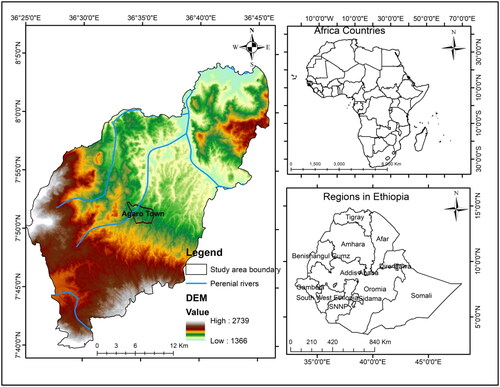
The estimated annual average precipitation (mm) of Gomma was about 1524, with a bimodal distribution. The rainy season in the study area was extended from May-September, with the highest shower usually recorded in August. It has a tropical highland climate distinguished by heavy rainfall, warm temperatures, and a long wet period. It was bimodally distributed, with minor rains occurring from March-April and the main rainy season occurring from June-October. As a result, crop yields were not inhibited through the spatial distribution of precipitation. The area recorded 13.4 °C and 29 °C in minimum and maximum temperatures, respectively.
2.2. Data used and sources
Cloud-free Satellite image of Landsat 8 was retrieved to produce the land masses cover of SWI potential classification (). Similarly, ASTER DEM was attained from the USGS to delineate watersheds, slopes, drainage density, flow accumulation, and direct generation. Water availability data, digital soil data, and lineament (geological data) were acquired from Oromia Water Works Design and Supervision Enterprise. To evaluate climate factors, 10 years of rainfall records were congregated from the NMA of Jimma District. A topographic map from the Geospatial Information Agency (GIA) was obtained to pattern the spot of river catchments. Finally, socioeconomic data were used as ancillary data. To this end, field investigations were conducted to collect training data for digital classification and ground verification applied to remote sensing.
Table 1. Source, description and purpose of the data used in the study.
2.3. Methods of data analysis
2.3.1. Spatial data analysis for suitability parameters
To minimize haze, the multispectral Landsat 8 image that covered the whole research area was preprocessed in ERDAS Imagine 2014. The image with a spatial resolution of 30 m was stacked and retrieved from the research area’s shapefile. Based on the authors’ existing information and shape and texture evaluation of the satellite image, six land use and land cover types were determined (settlement and cultivated land, forest, woodland, grassland, and dense woodland). To develop land use/land cover classes in the Gomma, training samples were collected and a supervised classification was used in ERDAS Imagine 2014. The classes’ accuracy was evaluated using ground truth sample points to compare what occurs on the ground (Lillesand et al., Citation2008). Accordingly, the surface irrigation potential produced map of the catchments extracted based on supervised classification met the minimum threshold (Congalton & Green, Citation2009). Finally, the classes as parameters were evaluated and ranked to evaluate the surface water irrigation potential in the Gomma.
The topographic setting of the area bounces an impression about the broad-spectrum orientation of water discharge and its trigger for surface irrigation potential reinstate, and ejection. Hence, the slope, drainage density, and river catchment delineation were generated from the DEM. The Food and Agricultural Organisation’s guideline was considered to reclassify and rank the value it can have on irrigation potential. Likewise, we consulted Tucker et al. (Citation2020) to evaluate the potential influence of drainage density in the Gomma. The five river catchments under study were delineated using the automatic delineation in the Arc hydro extension. Finally, the derived hydrology parameters, such as flow direction and drainage density, were calculated and analyzed.
The slope generated from DEM was reclassified into three suitability schemes: highly suitable, moderately suitable, and unsuitable, based on the circumstance of the Gomma and the FAO classification scheme. Similarly, soil samples for topsoil texture, PH, and stoniness were reclassified based on their suitability for crops. Likewise, water availability areas were identified, proximity was calculated, and suitability maps were produced in the Arc GIS environment.
Rainfall distribution on the gradient crow-fly shakes the intrusion rate of overflow aqua, thereby increasing the leeway of surface irrigation ultimate zones (He et al., Citation2021; Kumbhar et al., Citation2014). Precipitation records were compared and extracted via IDW, and it was clipped by the study area’s shapefile. The rainfall value was also reclassified, ranked, and weighted based on its influence on surface irrigation potential.
Multi-criteria evaluation (MCE) approach includes simultaneous consideration of multiple factors or criteria to make informed decisions regarding the suitability of a given area for irrigation purposes. Unlike traditional single-criterion assessments, MCE takes into account various aspects such as soil characteristics, climate conditions, topography, drainage patterns, and land use. Each criterion underwent reclassification into five and resampled into three classes excluding land use and land cover and soil classes. The parameters, including those not subject to reclassification, were transformed into ASCII format within the ArcGIS environment and then imported into IDRSI software for comparative analysis. In this regard, literature, experts, and guidelines set by the country were considered during class-to-class comparison for weighted overlay analysis. In this analysis, we applied the AHP to generate a weight for each determinant allowing to the participants’ pair-wise evaluation performance (Saaty, Citation1990). All criteria considered in this study can’t have identical unit of significance. Therefore, the prominence of factors virtual to the other triggers was evaluated by AHP. The comparison was made on a scale of 1–9, which spectacles the significance of the determining factors (EquationEquations (1)(1)
(1) and Equation(2)
(2)
(2) ). Accordingly, we characterized the zones as very good, moderate, and low. The evaluation of comparison consistency was conducted using EquationEquations (1)
(1)
(1) and Equation(2)
(2)
(2) , meeting the stipulated requirement with a consistency ratio of (Cr = 0.03). This indicates that the mentioned criteria were identified as significant factors for the selection of suitable SWI sites.
(1)
(1)
(2)
(2)
Where CI is the consistency index, RI is a relative index, λ the largest Eigenvalue of the pair-wise comparison matrix and n max is the number of factors.
By assigning weights to each criterion based on its relative importance, MCE enables the creation of suitability maps that highlight areas with optimal conditions for irrigation. The weighted linear combination technique (EquationEquation (3)(3)
(3) ) was employed to identify suitable SWI sites using the above parameters in the ArcGIS environment and MS Excel software (Saaty, Citation1990). Therefore, integrating the individual suitability maps to form a composite map, incorporating the designated weights assigned to each criterion.
(3)
(3)
Where Vi is the suitability index for the area i, Wj is the relative importance weight of criteria j, Vij is the grading value of area i under criterion j, n is the total number of criteria.
This allows stakeholders to make informed decisions on where to allocate resources and implement surface water irrigation schemes effectively.
3. Results
3.1. Suitability evaluation
depicts the landmass cover classes in the Gomma area that were utilized in categorizing the land cover into acceptable and unsuitable orders according to the most restrictive variables. This controlling variable embraces areas that are previously irrigated, forests, bamboo, woodlands, and settlements (). Crop-fields and shrubs classes were ranked as highly suitable by S1 and moderately suitable by S2, respectively (, ). On the other hand, the forest and drainage networks were registered as marginally noted by N1 and permanently unsuitable for SWI, respectively. Thus, the analyzed results revealed that 18,356.6 ha (25.13%), 15,235.64 ha (20.86%), and 52,874.35 ha (54%) of the total land of the Gomma fall under highly suitable, moderately suitable, and unsuitable categories for potential SWI, respectively. This suggests that about half percent of the target site falls in the array of moderately to highly suitable potential drip irrigation. Except for the northeastern part of the site, the remaining sites are equally important for SWI.
Figure 2. Land cover map (a), LULC suitability status (b), Slope map (c), Slope suitability status (d), Soil map (e), and Soil suitability status (f). Where CF is coffee farm with shade trees; ICL: intensively cultivated land; MCL: moderately cultivated land; NFC: natural forest cover; NFCC: natural forest cover with coffee; OWL: open wood; RF: riverine forest; SGL: savanna grassland; St: settlement; AS: acrisols; AS-LS: acri-lixisols; CS: cambisols; FS-LS: Fluvial-lixisols; LS: leptosols; NS: nitosols; VS: vertisols; LiS: lixisols.
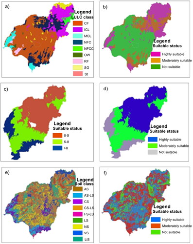
Table 2. Land cover evaluation suitability criteria description.
The land slope ranges used for this analysis were consulted according to FAO guidelines. In this regard, the results revealed that about 42,671.09 ha (16.31%) and 29,687.62 ha (49.36%) of the Gomma fall within highly suitable and moderately suitable for potential SWI, respectively, whereas the remaining 14,107.78 ha (34.33%) was investigated to be unsuitable (, ). This indicates that the slope of the study is a phenomenon for potential SWI.
Table 3. Slope suitability status.
The aptness of soil brands for SWI was appraised across their prospective for agronomic production (Halder, Citation2013; He et al., Citation2023; Tian et al., Citation2019). Among the five soil brands in the Gomma, nitosols were ranked as highly suitable for SWI. Fluvisols are rated as moderately suitable, and others are currently not suitable. Based on soil texture, the identified soil groups were reclassified into three major groups: eutric vertisols, humic alisols, and humic nitosols (). The analysis also revealed that humic nitosol, shielding 90% of Gomma, was categorized as highly suitable (). This is also distinguished by depth, size, draining conditions, and no salinity or alkalinity hazards. Haplic Luvisols, Chromic Luvisols, and Eutric Vertisol were categorized as moderately suitable, which embraces for about 7% of Gomma. By the same token, humic nitosols are restricted by their meager drainage: however, the other triggers are idyllic for SWI in the Gomma area.
The precipitation value in the Gomma area stretches from 1328–1920 mm. The highest rainfall (1688–1920 mm) and moderate rainfall (1555–1688 mm) cover 75.26 and 15.26%, respectively, and were deemed highly and moderately suitable for potential SWI (). Even though the study area receives high rainfall, it is usually exposed to leaching and discharge through very narrow and deep valley areas. In terms of agro-ecological zones, the rainfall is dependable and constant in the mid-land (Weyina Dega) zone, suggesting an upsurge in the likelihood of SWI (). In general, the southeast, southwest, southern, and eastern slices of the study area secure a lot of rain, yet the central and northwestern get moderate to a lot of rain. The dissemination of precipitation across the slope stanchly shakes the intrusion rate of overflow rainwater, thereby swelling the likelihood of water availability within the district. The drainage density Gomma ranged from 0 to 1.4 km/km2, with low drainage density (Dd) receiving the highest value and high Dd receiving the lowest value (). In this regard, 31.25 and 18.43% of the studies fall under the categories of highly suitable and moderately suitable, respectively.
Figure 3. Climate data in relation to the agro-ecological zones in the study area.
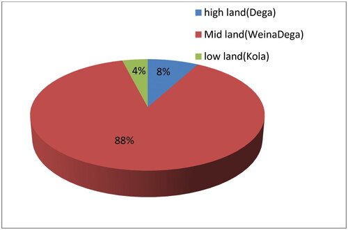
Table 4. Rainfall suitability status.
Table 5. Drainage density suitability status.
3.2. Integration of thematic layers and river catchment delineation for SWI
From the point of view of literature, experts, and local elders, all eight thematic maps: water availability, land use/land cover, proximity from the hydrologic networks, drainage density, soil texture, streamflow direction, rainfall, and slope rating were developed. As a result, a mathematical score scheme stretching from 1 to 9 was allocated to various classes of particular motifs based on the magnitude of the effect of distinct segments on the area’s SWI potential. These factors were weighted liable on their waves percentage on SWI embryonic, as shown in .
Table 6. Pair wise comparison matrix for irrigation suitability analysis.
Potentially irrigable areas were attained by producing a SWI model inquiry that twisted the weighting of values from the thematic factors. and indicate the overall SWI suitability analysis and identify potential irrigable lands in the study area. Accordingly, nearly 16 and 7.2% of the Gomma were floated to be highly and moderately suitable land for potential SWI, respectively.
Figure 4. Optimal suitable land for SWI potential for small holder farmers in the district.
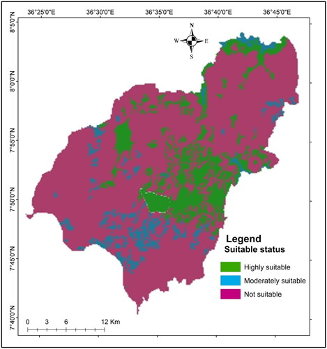
Table 7. The overall SWI potential possibilities in the study area.
The river catchment extraction publicized that there were five focal watersheds in the Gomma: Didessa, Naso, Awetu, Tamsa, and Urgessa, covering entire irrigational potential areas of 1838, 1626, 1484, 1107, and 910 ha, respectively (). Therefore, concerning perennial river catchments, the entire irrigation potential of the Gomma district is commenced to be 6965 ha. The smallholders in Didessa, Naso, Awetu, and Tamsa catchments could have great potential to secure their food via SWI, which reluctantly relies on unreliable rainfall.
Table 8. Irrigable and climatic zone of the study area.
4. Discussions
Water availability, LULC, distance from the water supply, drainage density, soil texture, stream flow direction, rainfall, and slope rating were settled to fuse a mathematical grading lengthening from 1 to 9. Accordingly, the grades were dispensed to classes established on the magnitude of bearings of discrete sorts on the surface irrigation potential of the area as consulted (Saaty, Citation1990). The factors were weighted based on their influence percentages on surface irrigation potential from the point of view of review literature, experts, and community interviews.
From the LULC categories of the Gomma, the crop-fields and shrubs were categorized as S1and S2 for SWI, respectively. This is in view of the fact that crop-fields will imminent for SWI deprived of limitations, and shrubs will does with fewer limitations. The bushland was ordered as marginally suitable for SWI, while the forest was chosen as permanently unsuitable. This is because the bushland tracts may be an answer when cultivable and shrubs are no longer available in the Gomma district. Forest cover is limited by the following costs to run irrigation (Hussainzada & Lee, Citation2022; Li & Chen, Citation2020; Tian et al., Citation2020; Wubalem, Citation2023). Therefore, it is impossible to irrigate the forest, as far as this study is concerned with surface irrigation. Similarly, implementing irrigation in forest and shrub areas has been highlighted in the Didhessa river basin (Dawit et al., Citation2020) and Ethiopia’s west-central highlands (Ayehu & Besufekad, Citation2015). The result of the analysis on the former study show that forest has been restricted, and finally, from the total area of Didhessa, 69.58% of the land was found to be potentially irrigable land, which covers the largest portion as it was compared to unsuitable areas.
A topography theme, the slope was characterized by very flat to flat dominant slopes ranging between 0 and 0.5%, flat to gentle dominant slopes ranging between 0.5 and 2%, gentle slope to undulating slope ranging between 2-5%, undulating to rolling slope between 5 and 8%, rolling to hilly slope stretching between 8 and 16%, hilly to steep slope between 16 and 30%, and abruptly dissected to rugged prevailing slopes over 30%. Studies recommend that flat areas are preferable for surface water irrigation to sloppy areas (Adham et al., Citation2016; Oulmane et al., Citation2022; Ramakrishnan et al., Citation2008; Tolera et al., Citation2023; Yin et al., Citation2023). Similarly, in this study, a slope classification of less than 2% was supposed to be optimally suitable for SWI. In this regard, the study confirms that areas that fall under less than 2% of slope topography are considered highly suitable for SWI to avoid erosion hazards and unnecessary production costs. Yet, the study suggests that in areas where the soil is suitable and water is available, slopes of up to 8–10% can be irrigated (Getahun et al., Citation2023; Kau et al., Citation2022; Li & Chen, Citation2020). Therefore, to avoid or minimize drainage problems, the lower and upper limits of the slope are set to 0.2–2%. The upper set of 2% for gravity flow irrigation is important to flow the water by gravity from the source to the command area and to gate-level land that is easy to machine. Areas with steep slopes are not suitable for SWI following the difficulty of constructing the scheme and the high vulnerability to erosion, as was mentioned before. Hence, constructing irrigation in that sloppy area is unadvisable and ruinous. Similarly, the area that receives lofty Dd weight has tower overflow and indicates a squat likelihood of aquatic convenience; henceforth, greater hefts are assigned to the low Dd plots and contrariwise. So, in conformity with the idea, the center and the southwestern part of the Gomma area has a high probability of water availability matched with the north tract.
Concerning slope suitability, the majority of the Gomma area is bizarrely suitable for SWI. The remaining areas, except for the southern areas, are hypothetically suitable. In this regard, about 24, 23.3, 21.3, and 16% of gradient suitable areas were found in the Dedessa, Neso, Awetu, and Temssa catchments, respectively. However, a relatively small portion of Gomma (11.7%) was investigated to be a suitable slope for the SWI of crops by smallholder peasants in the Erer watershed (Ayehu & Besufekad, Citation2015). Soil is among the most crucial parameters in SWI analysis. Whereas salinity and alkalinity peril are perhaps tweaked by better management habits, they committed to deliberate restraining triggers in the soil irrigation suitability assessment (Al-Taani et al., Citation2021; Abebe et al., Citation2023; Hussien et al., Citation2019; Zhu et al., Citation2022). In this regard, Nitisols are deep and well-drained, with 30% clay content and high aggregate stability. By the same token, studies have also been reported that nitosols license profound basing and brand these soils quietly unaffected by erosion and decent internal drainage and fair water-holding properties (Al-Adamat, Citation2017; Abebe et al., Citation2023; Deribew et al., Citation2022; Getahun et al., Citation2023; Hagos et al., Citation2022; Ismail et al., Citation2012; Omran, Citation2012).
Rainfall and temperature influence the growth and agricultural production of crops. These climate factors were classified into three classes; the higher the rainfall and low-temperature distribution area, the more suitable it was for SWI. This is because yields in parallel areas are exposed to dampness paucity following the toll of sunbeams. Similarly, a study conducted in the westbound of the Awash River found that evapotranspiration in the lower elevations was twofold as high as the annual average precipitation (Berhe et al., Citation2013). By the same token, other studies have also been reported in the Solapur district of Maharashtra (Kumbhar et al., Citation2014) and Changan County in China (Cheng et al., Citation2022; Dai et al., Citation2018). The Gomma’s austral and eastward regions get a lot of rain, whereas the medial and northwest tracts get a pretty of rain.
The decision-making analysis of AHP shows that water availability and slope, followed by rainfall and LULC, are the most important spatial layers in identifying suitable potential SWI at the watershed level. The Didessa is the largest river catchment of Gomma and its vicinities, chasing 1826 ha and embracing five river catchments. The catchment lies on a gentle to flat slope gradient and is covered with deeper soil on the open land and sparse shrub areas than other catchments found in the study area, suggesting most of the resource supplies were apposite for drip SWI. Contrary to many other findings, the optimal suitability map of the SWI tracts, particularly in the Didessa, Neso, and Awetu catchments were evenly distributed across the study area except for the western fringe (). Due to physical and hydrological triggers, the district’s western and southern margins are not possibly ideal regions for SWI. This point out that the lofty potential of the SWI tracts are traced in the northern, southeastern, southwestern, and eastern parts of the study area, which indicates a promise to improve crop productivity through medium- and large-scale SWI projects. In contrast to this study, the findings of the study can succor parish or national development agents in facilitating pilot surveys and preparing irrigation projects in the Gomma district.
5. Conclusions
Physical acreage developments are allowed in the southwestern portions of Ethiopia to lessen the gravity of food insecurity, flood dangers, and conservation management. Hence, sustaining the SWI may upsurge crop yields and improve the food stability level of the smallholders in the rural thrift, suggesting the expansion of SWI infrastructure across the river catchments. Potential SWI sites were identified using multiple-criteria decision-making analysis from the sources of information reviewed, which were applied for selecting suitable sites. Eight crucial parameters, namely, water availability, slope, rainfall, land use/land cover, settlement, drainage density, proximity to available drainages, and streamflow direction, were considered. The results of this analysis revealed that approximately 16 and 7.2% of the total study area falls under the categories of highly suitable and moderately suitable for drip or sprinkler irrigation, respectively. Contrary to many other findings, the ultimate SWI suitability maps of the Gomma’s sites, particularly in the Didessa, Neso, and Awetu catchments, were evenly distributed. The study’s verdicts may have an impact on food security, biodiversity conservation, ecosystem services, soil erosion control, and climate change regulation.
Regarding food security, approximately 1838, 1626, 1484, 1107, and 910 ha of Gomma district were scavenged to be the most irrigable catchments in Didessa, Naso, Awetu, Tamsa, and Urgessa for potential SWI, respectively. As a result, uniformly expanding infrastructural irrigation could help farmers escape poverty and reduce the flow of rural-urban migration. Therefore, supporting farmers through training on modern farming, seedlings, and market networks serves as a gentle pool to prosperity.
Furthermore, the eyewitness reveals that the soil loss-fertility nexus lessen are binary most substantial challenges confronting the highlands of the research area. Besides food security, our study shows that increasing irrigation infrastructure is an irreplaceable net to minimize erosion risk and fertility loss. Likewise, the availability of water supply and seedlings of plants in the catchments of potential irrigated land could regulate local climate change in the study area. Therefore, the potential high suitability SWI sites we analyzed show the likelihood of increasing food security, regulating climate change, and decreasing the risk of surface runoff.
Authors contributions
AM and KTD have designed the study. AM carried out fieldwork and collected data. AM and KTD carried out remote sensing analysis and document analysis. KTD and MM prepared the manuscript. KW contributed to manuscript editorials, and literature work.
Notes on contributors
The authors, senior lecturers and researchers at Ethiopian governmental higher institutions, passionate in diverse fields such as environmental modeling, land use dynamics, soil and climate studies, ecosystem management, forestry, hydrology, and urban-regional growth. Their passion for sustainable development permeates their work, reflected in numerous publications in reputable journals and voluntary reviewer roles. With a robust academic background and practical experience, they significantly contribute to advancing knowledge in their domains. Their voluntary service ensures the integrity of scholarly research. Overall, their multifaceted expertise and commitment to scientific excellence make them invaluable contributors to environmental science and sustainable development, not only within Ethiopia but also on a global scale.
Consent form
We agreed to submit the original manuscript to Cogent Food and Agriculture, and approved the original manuscript for submission.
Acknowledgments
The authors would like to thank Agaro Town’s water resource design and supervision team, as well as smallholder agrarians in the Dedessa, Nasu Awetu, and Tamsa catchments, for their assistance during parameter comparisons.
Disclosure statement
No potential conflict of interest was reported by the author(s).
Data availability statement
The data is included in the manuscript.
Additional information
Funding
References
- Abebe, M. S., Derebew, K. T., & Gemeda, D. O. (2019). Exploiting temporal-spatial patterns of informal settlements using GIS and remote sensing technique: a case study of Jimma city, Southwestern Ethiopia. Environmental Systems Research, 8(1), 1–13. https://doi.org/10.1186/s40068-019-0133-5
- Abebe, S., Deribew, K. T., Alemu, G., & Moisa, M. B. (2023). Modeling Eragrostis tef Zucc and Hordeum vulgare L cropland in response to food insecurity in the Southwestern parts of Ethiopia. Heliyon, 9(3), e14535. https://doi.org/10.1016/j.heliyon.2023.e14535
- Abedin, M. A., Collins, A. E., Habiba, U., & Shaw, R. (2019). Climate change, water scarcity, and health adaptation in southwestern coastal Bangladesh. International Journal of Disaster Risk Science, 10(1), 28–42. https://doi.org/10.1007/s13753-018-0211-8
- Adham, A., Riksen, M., Ouessar, M., & Ritsema, C. (2016). Identification of suitable sites for rainwater harvesting structures in arid and semi-arid regions: A review. International Soil and Water Conservation Research, 4(2), 108–120. https://doi.org/10.1016/j.iswcr.2016.03.001
- Al-Adamat, R. (2017). Modeling surface water susceptibility to pollution using GIS. Journal of Geographic Information System, 09(03), 293–308. https://doi.org/10.4236/jgis.2017.93018
- Alexandratos, N., & Bruinsma, J. (2012). World Agriculture towards 2030/2050: the 2012 Revision. ESA Working Paper No. 12-03. www.fao.org/economic/esa
- Al-Taani, A., Al-Husban, Y., & Farhan, I. (2021). Land suitability evaluation for agricultural use using GIS and remote sensing techniques: The case study of Ma’an Governorate, Jordan. The Egyptian Journal of Remote Sensing and Space Science, 24(1), 109–117. https://doi.org/10.1016/j.ejrs.2020.01.001
- Amiri, S. N., Khoshravesh, M., & Valashedi, R. N. (2023). Assessing the effect of climate and land use changes on the hydrologic regimes in the upstream of Tajan river basin using SWAT model. Applied Water Science, 13(6), 130. https://doi.org/10.1007/s13201-023-01932-3
- Araya, A., & Stroosnijder, L. (2011). Assessing drought risk and irrigation need in northern Ethiopia. Agricultural and Forest Meteorology, 151(4), 425–436. https://doi.org/10.1016/j.agrformet.2010.11.014
- Assefa, T. T., Jha, M. K., Tilahun, S. A., Yetbarek, E., Adem, A. A., & Wale, A. (2015). Identification of erosion hotspot area using GIS and MCE technique for Koga watershed in the upper Blue Nile Basin, Ethiopia. American Journal of Environmental Sciences, 11(4), 245–255. https://doi.org/10.3844/ajessp.2015.245.255
- Awulachew, S. B., & Ayana, M. (2011). Performance of irrigation: assessment at different scales in Ethiopia. Experimental Agriculture, 47(S1), 57–69. https://doi.org/10.1017/S0014479710000955
- Ayehu, G. T., & Besufekad, S. A. (2015). Land suitability analysis for rice production: A GIS-based multi-criteria decision approach. American Journal of Geographic Information System, 4(3), 95–104. https://doi.org/10.5923/j.ajgis.20150403.02
- Berhe, F. T., Melesse, A. M., Hailu, D., & Sileshi, Y. (2013). MODSIM-based water allocation modeling of Awash River Basin, Ethiopia. CATENA, 109, 118–128. https://doi.org/10.1016/j.catena.2013.04.007
- Bewket, W., & Conway, D. (2007). A note on the temporal and spatial variability of rainfall in the drought-prone Amhara region of Ethiopia. International Journal of Climatology, 27(11), 1467–1477. https://doi.org/10.1002/joc.1481
- Central Statistical Authority (CSA). (2015). Population projection of Ethiopia for all regions at Wereda level from 2014-2017. Central Statistical Agency.
- Cheng, M., Cui, Y., Yan, X., Zhang, R., Wang, J., & Wang, X. (2022). Effect of dual-modified cassava starches on intelligent packaging films containing red cabbage extracts. Food Hydrocolloids. 124, 107225. https://doi.org/10.1016/j.foodhyd.2021.107225
- Congalton, R. G., & Green, K. (2009). Assessing the accuracy of remotely sensed data: Principles and practices. 2nd ed. CRS Press. https://doi.org/10.1016/j.jag.2009.07.002
- Dai, X., Zhang, X., Han, Y., Chen, J., & Huang, H. (2018). Comparison of allocated irrigation water rights and irrigation water use under different perception probabilities: a case study in North China. Irrigation Science, 37(1), 49–60. https://doi.org/10.1007/s00271-018-0602-z
- Dawit, M., Olika, B. D., Muluneh, F. B., Leta, O. T., & Dinka, M. O. (2020). Assessment of surface irrigation potential of the Dihdhessa river basin, Ethiopia. Hydrology, 7(3), 68. https://doi.org/10.3390/hydrology7030068
- Deribew, K. T. (2019). Spatially explicit statistical modeling of random and systematic land cover transitions in the main grassland plain of Nec Sar National Park, Ethiopia. Ecological Processes, 8(1), 1–20. https://doi.org/10.1186/s13717-019-0199-z
- Deribew, K. T. (2020). Spatiotemporal analysis of urban growth on forest and agricultural land using geospatial techniques and Shannon entropy method in the satellite town of Ethiopia, the western fringe of Addis Ababa city. Ecological Processes, 9(1), 1–12. https://doi.org/10.1186/s13717-020-00248-3
- Deribew, K. T., & Dalacho, D. W. (2019). Land use and forest cover dynamics in the North-eastern Addis Ababa, central highlands of Ethiopia. Environmental Systems Research, 8(1), 2–18. https://doi.org/10.1186/s40068-019-0137-1
- Deribew, K. T., Mihretu, Y., Abreha, G., & Gemeda, D. O. (2022). Spatial analysis of potential ecological sites in the northeastern parts of Ethiopia using multi‑criteria decision‑making models. Asia-Pacific Journal of Regional Science, 6(3), 961–991. https://doi.org/10.1007/s41685-022-00248-5
- Fashae, O. A., Tijani, M. N., Talabi, A. O., & Adedeji, O. I. (2014). Delineation of groundwater potential zones in the crystalline basement terrain of SW-Nigeria: an integrated GIS and remote sensing approach. Applied Water Science, 4(1), 19–38. https://doi.org/10.1007/s13201-013-0127-9
- Foley, J. A., Ramankutty, N., Brauman, K. A., Cassidy, E. S., Gerber, J. S., Johnston, M., Mueller, N. D., Connell, C., Ray, D. K., West, P. C., Balzer, C., Bennett, E., Carpenter, S. R., Hill, J., Monfreda, C., Polasky, S., Rockström, J., Sheehan, J., Siebert, S., Tilman, D., & Zaks, D. P. M. (2011). Solutions for a cultivated planet. Nature, 478(7369), 337–342. https://doi.org/10.1038/nature10452
- Food and Agriculture Organization (FAO). (2012). Water statistics-water use report. https://www.unwater.org/statistics_use.html#sthash.UkqlyeGj.dpuf
- Getahun, Y. S., Gebremedhn, A. Y., Lemma, E., Tesfay, F., & Tadesse, S. A. (2023). Surface irrigation potential assessment of Chacha River Watershed, Jemma Subbasin of upper Blue Nile, Ethiopia. Frontiers in Environmental Science, 11(1129716), 1–22. https://doi.org/10.3389/fenvs.2023.1129716
- Gong, L., Ran, Q., Guixiang, H. E., & Tiyip, T. (2015). A soil quality assessment under different land-use types in Keriya river basin, Southern Xinjiang, China. Soil and Tillage Research. 146, 223–229. https://doi.org/10.1016/j.still.2014.11.001
- Guan, X., Yang, L., Zhang, Y., & Li, J. (2019). Spatial distribution, temporal variation, and transport characteristics of atmospheric water vapor over Central Asia and the arid region of China. Global Planet Change. 172, 159–178. https://doi.org/10.1016/j.gloplacha.2018.06.007
- Hagos, Y. G., Mengie, M. A., Andualem, T. G., Yibeltal, M., Linh, N. T. T., Tenagashaw, D. Y., & Hewa, G. (2022). Land suitability assessment for surface irrigation development at Ethiopian highlands using geospatial technology. Applied Water Science, 12(5), 1–11. https://doi.org/10.1007/s13201-022-01618-2
- Halder, J. C. (2013). Land suitability assessment for crop cultivation by using remote sensing and GIS. Journal of Geography and Geology, 5(3), 65–74. https://doi.org/10.5539/jgg.v5n3p65
- He, H., Tuo, S., Lei, K., & Gao, A. (2023). Assessing quality tourism development in China: an analysis based on the degree of mismatch and its influencing factors. Environment, Development and Sustainability. https://doi.org/10.1007/s10668-023-03107-1
- He, M.-Y., Dong, J.-B., Jin, Z., Liu, C.-Y., Xiao, J., Zhang, F., Sun, H., Zhao, Z.-Q., Gou, L.-F., Liu, W.-G., Luo, C.-G., Song, Y.-G., Ma, L., & Deng, L. (2021). Pedogenic processes in loess-paleosol sediments: Clues from Li isotopes of leachate in Luochuan loess. Geochimica et Cosmochimica Acta, 299, 151–162. https://doi.org/10.1016/j.gca.2021.02.021
- Hussainzada, W., & Lee, H. S. (2022). Effect of an improved agricultural irrigation scheme with a hydraulic structure for crop cultivation in arid northern Afghanistan using the Soil and Water Assessment Tool (SWAT). Sceinetifc Reports, 12, 5186:1–13. https://doi.org/10.1038/s41598-022-09318-2
- Hussien, K., Woldu, G., & Birhanu, S. (2019). A GIS-based multi-criteria land suitability analysis for surface water irrigation along the Erer watershed, Eastern Hararghe zone, Ethiopia. East African Journal of Sciences, 13(2), 169–184.
- IFAD. (2011). Rural poverty report: New realities new challenges: New opportunities for tomorrow’s generation, 322. IAFD.
- Ismail, M., Ghaffar, M. K., & Azzam, M. A. (2012). GIS application to identify the potential for certain irrigated agricultural uses on some soils in Western Desert, Egypt. The Egyptian Journal of Remote Sensing and Space Science, 15(1), 39–51. https://doi.org/10.1016/j.ejrs.2012.03.001
- Kau, A. S., Gramlich, R., & Sewilam, H. (2022). Modelling land suitability to evaluate the potential for irrigated agriculture in the Nile region in Sudan. Sustainable Water Resources Management, 9(1), 1–17. https://doi.org/10.1007/s40899-022-00773-3
- Kumbhar, V., Choudhury, S., Sen, A., & Singh, T. P. (2014). Assessment of irrigation and agriculture potential using geospatial techniques: A case study of “Bhima-Ujjani” project. Procedia - Social and Behavioral Sciences, 157, 277–284. http://creativecommons.org/licenses/by-nc-nd/3.0 https://doi.org/10.1016/j.sbspro.2014.11.030
- Li, H., & Chen, Y. (2020). Assessing potential land suitable for surface irrigation using groundwater data and multi-criteria evaluation in Xinjiang inland river basin. Computers and Electronics in Agriculture, 168, 105079. https://doi.org/10.1016/j.compag.2019.105079
- Li, J., Wang, Z., Wu, X., Zscheischler, J., Guo, S., & Chen, X. (2021). A standardized index for assessing sub-monthly compound dry and hot conditions with application in China. Hydrology and Earth System Sciences, 25(3), 1587–1601. https://doi.org/10.5194/hess-25-1587-2021
- Lillesand, T. M., Kiefer, R. W., & Chipman, J. (2008). Remote sensing and image interpretation. 6th ed. Wiley and Sons, Inc.
- Mirzaei, A., Azarm, H., & Naghavi, S. (2022). Optimization of cropping pattern under seasonal fluctuations of surface water using multistage stochastic programming. Water Supply, 22(6), 5716–5728. https://doi.org/10.2166/ws.2022.224
- Moisa, M. B., Merga, B. B., & Gemeda, D. O. (2022). Land suitability evaluation for surface irrigation using geographic information system: a case study in Didessa River Sub-Basin, Western Ethiopia. Sustainable Water Resources Management, 8(3), 82. https://doi.org/10.1007/s40899-022-00674-5
- Omran, E. E. (2012). A proposed model to assess and map irrigation water well suitability using geospatial analysis. Water, 4(3), 545–567. https://doi.org/10.3390/w4030545
- Oulmane, A., Kechar, A., Benmihoub, A., & Benmehaia, M. A. (2022). Assessment of surface water management institutions: a case of public irrigation schemes in northern Algeria. Water Policy, 24(2), 229–241. https://doi.org/10.2166/wp.2022.025
- Rahman, M., Pianosi, F., & Woods, R. (2023). Simulating spatial variability of ground table in England and Wales. Hydrological Processes, 37(3), 1–10. https://doi.org/10.1155/2023/1482229
- Ramakrishnan, D., Durga, Rao, K. H. V., & Tiwari, K. C. (2008). Delineation of potential sites for water harvesting structure through remote sensing and GIS techniques: a case study of Kali watershed, Gujarat, India. Geocarto International, 23(2), 95–108. https://doi.org/10.1080/10106040701417246
- Saaty, T. L. (1990). How to make a decision: The analytical hierarchy process. European Journal of Operational Research, 48(1), 9–26. https://doi.org/10.1016/0377-2217(90)90057-I
- Tercan, E., & Dereli, M. A. (2020). Development of a land suitability model for citrus cultivation using GIS and multi-criteria assessment techniques in Antalya province of Turkey. Ecological Indicators, 117(106549), 106549. https://doi.org/10.1016/j.ecolind.2020.106549
- Tian, H., Huang, N., Niu, Z., Qin, Y., Pei, J., & Wang, J. (2019). Mapping winter crops in China with multi-source satellite imagery and phenology-based algorithm. Remote Sensing, 11(7), 820. https://doi.org/10.3390/rs11070820
- Tian, H., Pei, J., Huang, J., Li, X., Wang, J., Zhou, B., Qin, Y., & Wang, L. (2020). Garlic and winter wheat identification based on active and passive satellite imagery and the google earth engine in Northern China. Remote Sensing, 12(21), 3539. https://doi.org/10.3390/rs12213539
- Tolera, A. M., Haile, M. M., Merga, T. F., & Feyisa, G. A. (2023). Assessment of land suitability for irrigation in West Shewa zone, Oromia, Ethiopia. Applied Water Science, 13(5), 1–18. https://doi.org/10.1007/s13201-023-01883-9
- Tucker, G. E., Catani, F., Rinaldo, A., & Bras, R. L. (2020). Statistical analysis of drainage density from digital terrain data. Geomorphology, 36(3-4), 187–202. https://doi.org/10.1016/S0169-555X(00)00056-8
- Usman, K., Deribew, K. T., Alemu, G., & Hailu, S. (2023). Spatial modeling of soil loss as a response to land use-land cover change in Didessa sub-basin, the agricultural watershed of Ethiopia. Heliyon, 9(3), e14590. https://doi.org/10.1016/j.heliyon.2023.e14590
- Worqlul, A. W., Collick, A. S., Rossiter, D. G., Langan, S., & Steenhuis, T. S. (2015). Assessment of surface water irrigation potential in the Ethiopian highlands: The Lake Tana Basin. CATENA, 129, 76–85. https://doi.org/10.1016/j.catena.2015.02.020
- Worqlul, A. W., Jeong, J., Dile, Y. T., Osorio, J., Schmitter, P., Gerik, T., Srinivasan, R., & Clark, N. (2017). Assessing potential land suitable for surface irrigation using groundwater in Ethiopia. Applied Geography, 85, 1–13. https://doi.org/10.1016/j.apgeog.2017.05.010
- Wu, X., Guo, S., Qian, S., Wang, Z., Lai, C., Li, J., & Liu, P. (2022). Long-range precipitation forecast based on multiple and preceding fluctuations of sea surface temperature. International Journal of Climatology, 42(15), 8024–8039. https://doi.org/10.1002/joc.7690
- Wubalem, A. (2023). Modeling of land suitability for surface irrigation using analytical hierarchy process method in Belessa Districts, northwestern Ethiopia. Heliyon, 9(3), e13937. https://doi.org/10.1016/j.heliyon.2023.e13937
- Yadeta, T., Deribew, K. T., Getahun, K., Debesa, G., Abreha, G., & Hailu, S. (2022). Recent resettlement programs, as drivers for Afromontane forest loss in the Hawa-Galan district of Ethiopia. Cogent Social Sciences, 8(1), 1–19. https://doi.org/10.1080/23311886.2022.2088462
- Yin, L., Wang, L., Tian, J., Yin, Z., Liu, M., & Zheng, W. (2023). Atmospheric density inversion based on swarm-C satellite accelerometer. Applied Sciences, 13(6), 3610. https://doi.org/10.3390/app13063610
- Zhu, X., Xu, Z., Liu, Z., Liu, M., Yin, Z., Yin, L., & Zheng, W. (2022). Impact of dam construction on precipitation: a regional perspective. Marine and Freshwater Research, 74(10), 877–890. https://doi.org/10.1071/MF22135