
 ?Mathematical formulae have been encoded as MathML and are displayed in this HTML version using MathJax in order to improve their display. Uncheck the box to turn MathJax off. This feature requires Javascript. Click on a formula to zoom.
Abstract
The challenge of swift and reliable earthquake location prediction within earthquake early warning (EEW) systems underscore the need for innovative solutions. Existing methods provide predictions, yet there is a clear demand for enhanced accuracy and expediency in the process of resolving. The article intends in prediction of both magnitude of earthquakes and the affected areas in a specific region, focusing on California, United States, by leveraging historical data using neural networks (NNs). Neural networks outperform other algorithms such as XGBoost, linear regression, random forest, gradient boosting and support vector machine (SVM), in terms of high R2 score and low score of MAE and also mean squared error (MSE). The derived results of R2 score, MSE and MAE are 0.1607, 0.1615 and 0.2951, respectively. It seamlessly integrates geospatial visualization through Folium and GeoPandas. These tools enhance the predictive model’s capabilities by generating dynamic maps enriched with markers, each representing the anticipated impact of earthquakes. The user interface facilitates interactive input, enabling users to input earthquake parameters for real-time predictions. The resultant map not only showcases the predicted impact zone but also provides valuable insights into the severity of seismic events. It stands as a testament to the synergy between machine learning and geospatial visualization, offering a holistic solution for earthquake prediction and geographical representation.
1. Introduction
The article addresses the critical need for advanced earthquake prediction and early warning systems, recognizing the inherent threat that earthquakes pose to communities worldwide. The primary objective is to focus on the enhancement of accuracy and speed at which the predictions of earthquake location are performed within the framework of detecting earthquakes at an early stage. This initiative specifically focuses on predicting both the magnitude of earthquakes and the corresponding affected areas, crucial for effective disaster mitigation.
Traditional approaches to earthquake prediction have historically relied on seismic sensors and historical data. However, this article leverages the power of neural network (NN) model to significantly improve the precision and adaptability of earthquake detection and severity assessment. By incorporating a diverse set of models under machine learning, including XGBoost, linear regression, random forest, gradient boosting and support vector machine (SVM), the system gains the capability to capture linear and non-linear relationships, intricate patterns, decision boundaries and relationships within complex geospatial and seismic datasets. This holistic approach results in more reliable predictions of both the magnitude of seismic events and the potential impact zones.
Beyond the utilization of machine learning algorithms, this article introduces an innovative solution that seamlessly integrates geospatial visualization through Folium and GeoPandas. This integration enhances the accuracy of earthquake predictions by providing a dynamic and interactive representation of the data. The inclusion of geospatial visualization not only improves the interpretability of the results but also transforms the system into an interactive tool. Users can engage in real-time input, obtaining immediate insights into anticipated impact zones and fostering a proactive approach to disaster preparedness.
The synergy between advanced predictive models and geospatial visualization represents a comprehensive paradigm for accurate and expeditious earthquake prediction and early warning systems. The integration of machine learning not only refines predictive capabilities but also enables the system to adapt to evolving patterns and complexities in seismic data. By combining these advanced models with interactive mapping, the project aims to address the challenges associated with seismic event mitigation, ultimately contributing to the development of more resilient and informed communities.
This initiative stands at the intersection of machine learning, geospatial visualization and earthquake magnitude prediction, offering a comprehensive solution that transcends traditional methods. The goal is to empower communities with timely and accurate information, fostering a proactive approach to earthquake preparedness and ensuring the safety and resilience of societies facing the constant threat of seismic events.
2. Literature survey
Saad et al. (Citation2022)’s synthetic datasets compensate for sparse station distribution, enabling effective training despite data shortages in certain areas. Kong et al. (Citation2016)’s recorded seismic waveforms have potential applications in creating rapid microseism maps, assessing building impacts and studying shallow earth structure and earthquake rupture kinematics. Chin et al. (Citation2020) discuss earthquake early warning (EEW) systems in Taiwan, a highly seismic region. Saad et al. (Citation2021) algorithm’s speed and high accuracy lets it adapt to different geographical areas by training it with earthquake data from those regions, promising potential applications in earthquake monitoring and early warning systems. Umar et al. (Citation2013) suggest a community-based early warning system using rainfall thresholds and recommends installing rainfall gauges in groups of 10–20 houses around hills to monitor and alert residents during heavy rains, enhancing safety measures.
Maddaloni et al. (Citation2013) explore the integration of two seemingly unrelated technologies in seismic engineering: semi-active (SA) control, aimed at mitigating seismic effects on structures and seismic early warning (SEW). Sherki et al. (Citation2015) introduce an EEW system that combines sensor design and advanced signal processing techniques. Cho et al. (Citation2022) focus on improving EEW systems’ accuracy, particularly in the Korean Peninsula, to prevent missed alarms or false alarms that may lead to casualties or economic losses. Alphonsa and Ravi (Citation2016) present the implementation of wireless sensor network (WSN) with Internet of Things for early prediction of earthquake. Suprijanto et al. (Citation2013), introduce a method for improving the accuracy of P-wave arrival time detection in seismic signals. Wu et al. (Citation2015) address the limitations of predicting earthquake early in handling multiple concurrent earthquakes by proposing Bayesian probabilistic approach.
Mousavi and Beroza (Citation2020) introduce MagNet, an NN inspired model is used to predict the magnitude of earthquake directly from the waveform data at each station. Zhang et al. (Citation2020) provide rapid automated location estimates, without requiring velocity models or human intervention. Al Amin et al. (Citation2015), address the longstanding challenge of early earthquake detection, offering a promising solution. Kwon et al. (Citation2020) discuss the implementation of a working earthquake detection system in South Korea using low-cost micro-electro-mechanical systems (MEMS) sensors. Ohsumi (Citation2013) addresses EEW limitations, namely inaccurate estimation of magnitude and intensities for earthquake during high risk events, and suggests counter measures. Saad et al. (Citation2017) present a technique is efficient even under low signal-to-noise ratio (SNR) conditions.
Kislov et al. (Citation2012) present methods and algorithms for real-time identification of waveform arrivals from local earthquakes amid high man-induced noise levels for EEW. Mehrazarin et al. (Citation2016) make use of open source library to detect vibrations and to translate them into seismograph. Pirenne et al. (Citation2014) focus on creating an integrated geo-hazard alert system. Wu et al. (Citation2007) discuss the phenomenon of satellite thermal infrared (TIR) anomalies preceding earthquakes and proposes a mechanism for interpreting these anomalies. Saad, Shalaby, et al. (Citation2017) present a novel approach for predicting the earthquakes at an early stage by detecting the onset of earthquakes. Chandrakant et al. (Citation2012) introduce an innovative approach to earthquake prediction through WSNs by using mobile biological sensors of animals.
3. Proposed methodology
The existing methods show case that they provide predictions, yet there is a clear demand for enhanced accuracy and expediency in the process of resolving. The article intends in prediction of both magnitude of earthquakes and the affected areas in a specific region, focusing on California, United States, by leveraging historical data using NNs. The application implements a machine learning pipeline and outputs results that include affected area calculation, magnitude prediction using machine learning models, model evaluation and geospatial visualization.
3.1. Machine learning pipeline
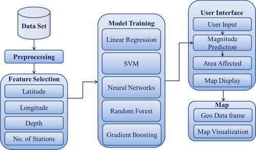
The code implements a comprehensive machine learning pipeline that includes data loading, preprocessing, model training and evaluation. It covers a variety of regression models, offering flexibility in choosing the most suitable algorithm for earthquake magnitude prediction. It seamlessly integrates geospatial visualization through Folium and GeoPandas. These tools enhance the predictive model’s capabilities by generating dynamic maps enriched with markers, each representing the anticipated impact of earthquakes.
3.2. Earthquake magnitude prediction
The primary goal of the application is to predict earthquake magnitudes using different regression models. The code successfully trains XGBoost, linear regression, random forest, gradient boosting and SVM models for this purpose. The article aims at integrating Folium and Geopandas with the above-mentioned machine learning models. The process aims at obtaining better accuracy with minimal error rate in predicting the magnitude of earthquake.
3.3. Affected area calculation
The model calculates the affected area based on predicted magnitude and depth. This provides additional insights in to the potential impact of earthquakes, extending the application beyond magnitude prediction. The basic machine learning pipeline architecture presented in is referenced from Krishna Bhargavi et al. (Citation2021) and is applied to the present model in predicting the magnitude and depth.
Figure 1. Machine learning pipeline for earthquake detection and prediction.
3.4. Linear regression
In the context of earthquake prediction, linear regression aims to establish a linear equation between seismic features (independent features) and earthquake magnitude (dependent feature). The model represents the relationship as a linear model and tries to fit the best fitting line that has minimal sum of squared difference between the observed and predicted magnitudes. The algorithm iteratively adjusts weights using gradient descent to reduce the difference in magnitudes among the actual and predicted values.
3.5. Linear regression model
Load earthquake data from CSV file.
Earthquake data is divided into training and testing datasets.
Initialize a linear regression model.
(1)
- pred_mag is the magnitude that is to be predicted
- Icpt indicates the intercept
- cof1, cof2, cof3, and cof4 are the coefficients for features Ftr1, Ftr2, Ftr3 and Ftr4
- Ftr1, Ftr 2, Ftr 3 and Ftr 4 are the selected features (latitude, longitude, depth and number of stations) respectively.
- ε is the error term.
Ordinary least squares (OLS) method is used to train the training dataset and minimizes the error that may be caused with sum of squares.
Predict the magnitude on the testing set, to check how well the model fits.
Calculate R2 score, mean absolute error (MAE) and mean squared error (MSE) are calculated using the following formulae:
- test_magis the actual magnitude.
3.6. Random forest
In this application, a Random Forest regressor is constructed by initializing the hyper parameters. The trained random forest model is used to make predictions on the test data set.
3.6.1. Random forest regression model
Hyper parameters for random forest regressor are initialized.
Number of trees = 100
Random seed = 42
The constructed regressor is fitted using training data.
- X_test contains features, such as latitude, longitude, depth and number of stations.
- N is the number of trees initialized in the random forest.
Predict the earthquake location on the test data using the ensemble of decision trees.
Calculate the evaluation metrics R2 and MSE.
3.7. Support vector machine
In this application, SVMs are used for earthquake magnitude classification based on the ‘Magnitude_type’ column. Four SVM instances are initialized, each corresponding to a different magnitude type (‘ML’, ‘Mx’, ‘Md’ and others). The RBF kernel is used for all SVM instances. Each instance of SVM is trained using subsets of training data. Binary labels are generated for each SVM instance, indicating whether an earthquake belongs to a specific magnitude type. The fit method is used to train each SVM model on its respective subset of the data. The code utilizes SVMs to classify earthquake magnitude types based on specific features. The SVMs are trained using subsets of training data, and their decision boundaries are visualized for better understanding.
3.7.1. Support vector machine model
Import necessary libraries.
Select a subset of the training data.
Create an SVM regressor with a radial basis function (RBF) kernel.
Decision Function:
- γ is a parameter in the RBF kernel.
Train the SVM regressor on the subset or full training data.
Evaluate the model on the test set.
Calculate the evaluation metrics R2 and MSE.
3.8. XGBoost
XGBoost is an optimized gradient boosting algorithm that sequentially builds weak learners to create a strong learner. The negative gradient from the loss function is used to fit the weak learner. The predictions are updated using shrinkage factor.
3.8.1. XGBoost model
Initialize an XGBoost regressor.
Fit the regressor to the training data using gradient boosting.
- X_test contains features such as latitude, longitude, depth and number of stations
- γ is the regularization term.
Predict the target variable on the test data.
Calculate the evaluation metrics R2 and MSE.
3.9. Neural network
In this application, a NN is trained using scikit-learn’s MLP Regressor on earthquake data. The NN uses features like latitude, longitude, depth and the number of stations to predict earthquake magnitudes. It is evaluated on a test set, and various visualizations are employed for analysis. Users can input specific parameters to get real-time magnitude predictions based on the trained NN model.
3.9.1. Neural network model
Import necessary libraries
Standardize the input features
Initialize the NN regressor
Fit the regressor to the training data Predict on the testing set
Calculate the evaluation metrics R2 and MSE.
- X_test contains features such as latitude, longitude, depth and number of stations.
- γ is the regularization term.
3.10. Gradient boosting
Gradient Boosting sequentially builds a series of weak learners, each correcting errors of the previous one. The negative gradient from the loss function is used to fit the weak learner. The predictions are updated using learning rate.
3.10.1. Gradient boosting model
Import necessary libraries.
Initialize Gradient Boosting regressor.
3.10.2. Iterative training
where
3.11. Final prediction
Fit the regressor to the training data.
Predict on the testing set.
Calculate the evaluation metrics R2 and MSE.
4. Results and discussion
R2, MAE and MSE and are compared among the aforesaid methods using formulae given in Equations (2), (3) and (4). The following table provides the comparison of these metrics among different machine learning models. It can be clearly understood from the table that NNs outperformed the remaining machine learning model. The results specified in are obtained by executing the different machine learning models for testing against various metrics.
Table 1. Comparison of metrics among machine learning model.
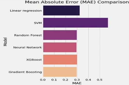
The following figures depict the comparison of metrics among the aforementioned algorithms and the visual representation is obtained from Matplotlib library in Python. represents the MAE comparison among the machine learning methods. SVM is identified to obtain more MAE when compared to other algorithms. Random forest, NN, XGBoost and Gradient Boosting obtained almost the same MAE score.
Figure 2. Comparison of mean absolute error among machine learning models.
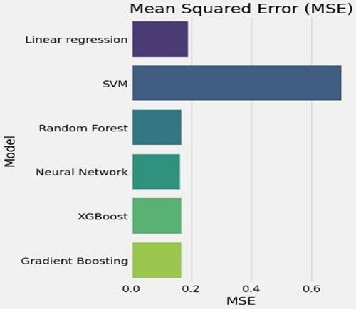
represents the MSE comparison among the machine learning methods. It can be clearly visualized that SVM model obtained more MSE value. Other machine learning models NN, Random forest, gradient boosting and XGBoost almost obtained lesser error rate when compared to linear regression and SVM models.
Figure 3. Comparison of mean absolute error among machine learning models.
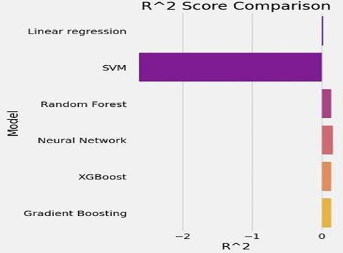
represents the MSE comparison among the machine learning methods. The figure clearly demonstrates that SVM obtained negative R2 score and NN, Random forest, gradient boosting and XGBoost obtained positive values. It clearly indicates that these models outperform SVM and Linear regression models.
Figure 4. Comparison of mean absolute error among machine learning models.
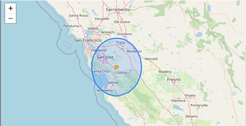
represents the importance of features in the NN model and represents the graph among actual and predicted magnitude values. are the depictions of the usage of Folium and Geopandas packages of Python.
Figure 5. Importance of features.
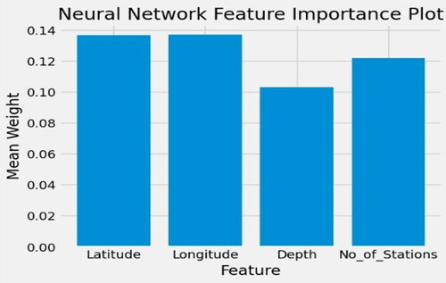
Figure 6. Actual versus predicted magnitude.
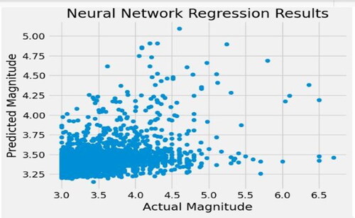
Figure 7. Result of machine learning model.
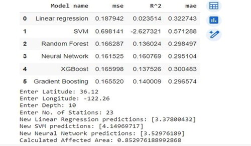
Figure 8. Visual representation of predictions.
5. Conclusion
In conclusion, this article presents a comprehensive solution for earthquake prediction and geospatial visualization that intended in improving the accuracy of prediction and also the precision in identification of location within the earthquake early prediction systems. By leveraging historical data and employing various machine learning models, the project focuses on predicting both the magnitude of earth quakes and the affected areas in California, United States. The integration of geospatial visualization tools like Folium and GeoPandas enhances the predictive model’s capabilities, providing dynamic maps enriched with markers that represent the anticipated impact of earthquakes. The user interface allows for interactive input, enabling users to input earthquake parameters for real-time predictions. The resulting map not only showcases the predicted impact zone but also offers valuable insights into the severity of seismic events. This article provides a holistic solution for earthquake prediction and geographical representation using NNs as it outperforms other algorithms such as XGBoost, Linear Regression, Random Forest, Gradient Boosting and SVM in terms of high R2 score and low score of MAE and also MSE.
Authors’ contributions
Conceptualization – Dr. Y. Krishna Bhargavi; Methodology – GangulaVarshitha Reddy, YellineniPranathi, R. Sneha and S. Gayathri; Investigation – GangulaVarshitha Reddy, YellineniPranathi, R. Sneha and S. Gayathri; resources – Yellineni Pranathi; data curation – Upendra Dabral; writing and original draft preparation – Dr. Y. Krishna Bhargavi; writing: review and editing – Solovev S. A.; visualization – Nikolai IvanovichVatin; supervision – Dr. Y. Krishna Bhargavi; project administration – Dr. Y. Krishna Bhargavi.
Disclosure statement
The authors declare no conflict of interest.
Data availability statement
The data that support the findings of this study are openly available in NCEDC (2014), Northern California Earthquake Data Center. UC Berkeley Seismological Laboratory Dataset at http://doi.org/10.7932/NCEDC.
Additional information
Funding
References
- Al Amin, A., Mahmudul Hasan, Kazi Sinthia Kabir, Tanzila Choudhury, & A. B. M. Alim Al Islam. (2015). Early detection of earthquake using satellite based quantum computing [Paper presentation]. 2015 4th International Conference on Computer Science and Network Technology (ICCSNT), (pp. 1079–82). https://doi.org/10.1109/ICCSNT.2015.7490923
- Alphonsa, A., & Ravi, G. (2016). Earthquake early warning system by IOT using Wireless sensor networks [Paper presentation]. 2016 International Conference on Wireless Communications, Signal Processing and Networking (WiSPNET), (pp. 1201–1205). Chennai, India. https://doi.org/10.1109/WiSPNET.2016.7566327
- Chandrakant, N., Poojar, S., Deepa Shenoy, P., Venugopal, K. R., & Patnaik, L. M. (2012). Middleware service oriented earthquake detection in advance using WSNs [Paper presentation]. 2012 Fourth International Conference on Advanced Computing (ICoAC), (pp. 1–8). Chennai, India. https://doi.org/10.1109/ICoAC.2012.6416857
- Chin, T. L., Chen, K. Y., Chen, D. Y., & Lin, D. E. (2020). Intelligent real-time earthquake detection by recurrent neural networks. IEEE Transactions on Geoscience and Remote Sensing, 58(8), 5440–5449. https://doi.org/10.1109/TGRS.2020.2966012
- Cho, S., Ahn, J. K., & Hwang, E. H. (2022). Optimization of network-based earthquake early warning systems on the Korean Peninsula. IEEE Access, 10, 83931–83939. https://doi.org/10.1109/ACCESS.2022.3197661
- Kislov, K., Vinberg, F., Kushnir, A., & Gravirov, V. (2012). Early warning system and man-made noise [Paper presentation]. 2012 IV International Conference "Problems of Cybernetics and Informatics" (PCI), (pp. 1–4). Baku, Azerbaijan. https://doi.org/10.1109/ICPCI.2012.6486342
- Kong, Q., Allen, R. M., Schreier, L., & Kwon, Y. W. (2016). MyShake: A smartphone seismic network for earthquake early warning and beyond. Science Advances, 2(2), e1501055. https://doi.org/10.1126/sciadv.1501055
- Krishna Bhargavi, Y., Dr.Ssr Murthy, Y., Dr., & Srinivasa Rao, O. (2021). A real and accurate semantic search indexing approach using ASVM machine in big data analytics. International Journal of Engineering Trends and Technology, 69(2), 144–159. https://doi.org/10.14445/22315381/IJETT-V69I2P221
- Kwon, Y. W., Ahn, Jae-Kwang, Lee, Jimin, & Lee, Chul-Ho. (2020). Earthquake early warning using low-cost MEMS sensors [Paper presentation]. IGARSS 2020–2020 IEEE International Geoscience and Remote Sensing Symposium, (pp. 6635–6637). https://doi.org/10.1109/IGARSS39084.2020.9323438
- Maddaloni, G., Caterino, N., & Occhiuzzi, A. (2013). Smart passive control of seismic structural vibrations exploiting early warning information [Paper presentation]. 2013 IEEE Workshop on Environmental Energy and Structural Monitoring Systems, (pp. 1–5). Trento, Italy. https://doi.org/10.1109/EESMS.2013.6661700
- Mehrazarin, S., Bin Tang, K. Leyba, Jianchao Han & Beheshti, M. (2016). A MacBook based earthquake early warning system [Paper presentation]. 2016 IEEE Conference on Computer Communications Workshops (INFOCOM WKSHPS), (pp. 1029–1030). https://doi.org/10.1109/INFCOMW.2016.7562237
- Mousavi, S. M., & Beroza, G. C. (2020). A machine‐learning approach for earthquake magnitude estimation. Geophysical Research Letters, 47(1), e2019GL085976. https://doi.org/10.1029/2019GL085976
- Ohsumi, T. (2013). Development of real-time damage estimation system for embankment using earthquake early warning [Paper presentation]. 2013 International Conference on Signal-Image Technology & Internet-Based Systems, (pp. 854–859). Kyoto, Japan. https://doi.org/10.1109/SITIS.2013.139
- Pirenne, B., Rosenberger, A., Guillemot, E., & Jenkyns, R. (2014). The web-enabled awareness research network (WARN) project early earthquake and tsunami warning at ocean networks Canada [Paper presentation]. Oceans - St. John’s, (pp. 1–7). https://doi.org/10.1109/OCEANS.2014.7003176
- Saad, O. M., & Shalaby, A., et al. (2017) Automatic arrival time detection for earthquakes based on logarithmic transformation [Paper presentation]. 2017 29th International Conference on Microelectronics (ICM), (pp. 1–4). https://doi.org/10.1109/ICM.2017.8268867
- Saad, O. M., Chen, Y., Trugman, D., Soliman, M. S., Samy, L., Savvaidis, A., Khamis, M. A., Hafez, A. G., Fomel, S., & Chen, Y. (2022). Machine learning for fast and reliable source-location estimation in earthquake early warning. IEEE Geoscience and Remote Sensing Letters, 19, 1–5. https://doi.org/10.1109/LGRS.2022.3142714
- Saad, O. M., Hafez, A. G., & Soliman, M. S. (2021). Deep learning approach for earthquake parameters classification in earthquake early warning system. IEEE Geoscience and Remote Sensing Letters, 18(7), 1293–1297. https://doi.org/10.1109/LGRS.2020.2998580
- Saad, O. M., Shalaby, A., & Sayed, M. S. (2017). Automatic arrival time detection for earthquakes based on fuzzy possibilistic C-Means clustering algorithm [Paper presentation]. 2017 8th International Conference on Recent Advances in Space Technologies (RAST), (pp. 143–148). Istanbul, Turkey. https://doi.org/10.1109/RAST.2017.8003001
- Sherki, Y., Gaikwad, N., Chandle, J., & Kulkarni, A. (2015). Design of real time sensor system for detection and processing of seismic waves for earthquake early warning system [Paper presentation]. 2015 International Conference on Power and Advanced Control Engineering (ICPACE), (pp. 285–289). Bengaluru, India. https://doi.org/10.1109/ICPACE.2015.7274959
- Suprijanto, T., Istiana, Hariyanto., & N. A., Dian. (2013). Detection of P-wave on broadband seismometer using discrete wavelet denoising [Paper presentation]. 2013 3rd International Conference on Instrumentation Control and Automation (Ica), (pp. 110–114). Ungasan, Indonesia. https://doi.org/10.1109/ICA.2013.6734055
- Umar, Z., Ahmad, A., & Akib, W. A. A. W. M. (2013). Early warning system for landslide hazard caused by earthquake and rainfall in West Sumatera Province, Indonesia [Paper presentation]. IEEE International Conference on Control System, Computing and Engineering, (pp. 541–546). Penang, Malaysia. https://doi.org/10.1109/ICCSCE.2013.6720024
- Wu, L., Liu, S., Wu, L., Li, J., Dong, Y., & Xu, X. (2007). Theoretical analysis to impending tectonic earthquake warning based on satellite infrared anomaly [Paper presentation]. 2007 IEEE International Geoscience and Remote Sensing Symposium, (pp. 3723–3727). Barcelona, Spain. https://doi.org/10.1109/IGARSS.2007.4423652
- Wu, S., Yamada, M., Tamaribuchi, K., & Beck, J. L. (2015). Multi-events earthquake early warning algorithm using a Bayesian approach. Geophysical Journal International, 200(2), 791–808. https://doi.org/10.1093/gji/ggu437
- Zhang, X., Zhang, J., Yuan, C., Liu, S., Chen, Z., & Li, W. (2020). Locating induced earthquakes with a network of seismic stations in Oklahoma via a deep learning method. Scientific Reports, 10(1), 1941. https://doi.org/10.1038/s41598-020-58908-5